Grow with the Flow
When Bradley Hill arrived in Flagstaff, Arizona, to become its first water manager in 2007, the high-desert city had spent decades working to ensure a sustainable water supply for its growing population. But Hill immediately noticed a missing link: “The planning group and water group didn’t talk to each other,” says Hill, now water services director. “The planners were planning subdivisions without talking to the water supply guys.”
In his prior post as water manager in Peoria, a major suburb of Phoenix, Hill had introduced a pioneering approach to integrated water conservation and land planning. Seeking to connect the dots between growth and water in Flagstaff, Hill secured support to introduce a similarly collaborative approach—one that has helped the city plan to meet its water needs into the next century.
Across the arid and rapidly urbanizing Southwestern United States, planning for the future availability of water has taken on a new urgency in the face of multiyear drought, trends toward higher temperatures, and the uncertainty of climate-related changes. As recognition of the relationship between water demand and the built environment increases, collaboration between urban planners and water resources specialists is on the rise. The evidence is mounting that tools such as dedicated water master plans, new zoning approaches, and comprehensive plans embedded with policies that address a wide range of water-use issues can help communities plan better.
The Benefits of Integrated Land and Water Planning
Communities that integrate land use and water planning report multiple benefits, according to the Coordinated Planning Guide: A How-To Resource for Integrating Alternative Water Supply and Land Use Planning. These include:
- Increasing water supply sustainability at reduced costs
- Securing water supplies, such as recycled water, that are independent of weather
- Reducing competition for limited water supplies
- Resolving conflict among plans for land use, economic development, and regional or statewide water use
- Improving water management plans, data development, and data sharing
- Addressing urban flooding by integrating low-impact development design into land use planning
- Increasing predictability within the development process
But there’s still a long way to go. “With water and land-use planning, we’re where we were years ago with early transit-oriented and mixed-use development,” says Peter Pollock, former manager of Western Programs at the Lincoln Institute of Land Policy and former planning director in Boulder, Colorado. “[We’re] trying to guess what it will be like and what our water needs will be.”
In 2017, the Lincoln Institute’s Babbitt Center for Land and Water Policy conducted a review of more than 150 comprehensive plans from communities in Arizona and Colorado to assess how—or whether—they address water in the course of land planning. Both states require all local jurisdictions to complete comprehensive plans; Arizona requires those plans to integrate water-related issues. Still, when it came down to it, the Babbitt Center team detected a certain scarcity.
“Very few comprehensive plans actually have links between water and land,” says Babbitt Center research fellow Erin Rugland, who conducted the analysis (Babbitt Center, forthcoming). “A lot of water planning is very cursory and general within comprehensive plans. Even communities with an integrated water resource plan may not link land and water in their comprehensive plan.”
Some communities, however, are modeling different approaches. Flagstaff “hit every review criteria” in her study, says Rugland, noting the city excels in its conservation programs, water-demand projections, and regional collaborations. And in Westminster, Colorado, planners are crunching numbers in new ways to glean better insights into future needs: “Westminster has excelled at incorporating water into its zoning and development processes,” says Rugland. Here’s a closer look at the innovations afoot in two small cities facing considerable pressures from growth.
Flagstaff, Arizona
Situated at an elevation of 7,000 feet on the Colorado Plateau in Northern Arizona, Flagstaff is essentially a high-desert urban island surrounded by thousands of acres of national forests, monuments, and other public land. This booming city is home to 73,000, a population that surged 25 percent between 2000 and 2010; that number could grow to 90,000 by 2040, according to state projections. The city’s 64 square miles offer no access to Colorado River water or any running rivers, and the extended drought in the region has limited average annual precipitation to a mere 22 inches. On top of all that, the city is the primary water provider within the region, also serving unincorporated areas of Coconino County. As a result, Flagstaff has “one of the most challenging water situations in the state,” says Brad Hill.
That’s a meaningful claim in a state that is intensely aware of its vulnerabilities regarding water.
Arizona saw trouble coming decades ago. In 1980, the state legislature passed the groundbreaking Groundwater Management Act in an effort to carefully allocate Arizona’s limited groundwater resources. The legislation created four “active management areas” (AMAs), later expanded to five, which include metro areas such as Phoenix and Tucson. As Jeff Tannler of the Arizona Department of Water Resources (ADWR) explains, “Before recording plats or selling parcels within an AMA, developers must demonstrate an assured 100-year water supply. Outside of AMAs, a developer must disclose to potential first purchasers of subdivided lots whether the water supply is adequate.”
While the latter is advisory in nature—land outside an AMA can still be subdivided and sold without an adequate water supply as long as the buyer is notified—Tannler says both programs “consider current and committed demand as well as growth projections, and both incorporate long-term water supply planning.” Subsequent legislation made it possible for cities and towns—or counties by a unanimous vote of their governing body—to adopt an ordinance making the adequacy rules mandatory within their jurisdiction. Two counties and two towns in Arizona have adopted such an ordinance.
A more recent piece of statewide legislation, the Growing Smarter Plus Act of 2000, requires every local jurisdiction to develop a comprehensive plan that describes a physical supply of available water, projects water demand based on predicted population growth, and explains how future water demand will affect the water supply. This legislation “strengthened how water is talked about in the comprehensive plans for big cities like Phoenix and its metro area,” says Rugland. However, she notes a caveat: The defunding of the Arizona Commerce Department office that reviewed comprehensive plans has meant little oversight in smaller cities and towns regarding good planning for linking land and water.
Among the water-wise practices local jurisdictions are incorporating into their comprehensive plans: Tucson limits thirsty turf grass, allows greywater reuse on landscapes, and requires high-efficiency water fixtures in new developments; Chandler requires nonresidential developments that exceed municipal water allotments to apply for an exemption to the city council or purchase their own water; and Peoria established an economic valuation per gallon of water to help assess the impact of new development.
Against this backdrop, Flagstaff has been finding its own solutions. The city drilled its first well outside the city limits in 1954, and in the late 1990s it began drilling wells inside the city. Wells are a difficult and costly groundwater source: Boring through 2,000 feet of the same sandstone, shale, and limestone layers that form the Grand Canyon costs about $3 million for each well, says Hill. But the wells help reduce the city’s reliance on surface water such as snowmelt, which is unreliable in drought conditions. Groundwater now accounts for about 60 percent of the city’s water.
In 2005, the city made a major investment in securing a sustainable water supply by purchasing Red Gap Ranch, an 8,500-acre property located 40 miles to the east. The ranch, which borders Navajo Nation land, has high groundwater yields that could meet projected water demands for Flagstaff, with minimal impact to the aquifer. The city has drilled 11 wells at Red Gap Ranch, but the idea of building a 40-mile pipeline to transport the resulting water is ambitious, costly, and controversial.
With feasibility studies on the Red Gap pipeline continuing, Flagstaff completed a study in 2012 that quantified its total water supply to provide baseline data for growth. In 2013, ADWR designated Flagstaff as having an adequate water supply for 100 years, including Red Gap Ranch. The following year, the voters approved Flagstaff Regional Plan 2030, a comprehensive plan for the city and county that contains a chapter on water resources with goals and policies related to low-water development strategies, green infrastructure, and water infrastructure financing, as well as information such as water use per capita and per sector (City of Flagstaff 2014). The vision is that by 2030, the water supply will be maintained through conservation, reuse, innovative treatment technologies, and smart development choices.
“One of the things Flagstaff has done well is we didn’t wait for a crisis to begin planning for water,” says Sara Dechter, comprehensive planning manager. “We can develop for the next 100 years—not 20 years like most comprehensive plans.”
Every administrative site plan review or zoning request includes an impact analysis to determine whether water can be delivered to the site through existing infrastructure or a new well is needed, and how the project will work within the city’s water budget. Among its forward-looking policies, the city has identified higher-density, mixed-use infill projects as a way to plan within its water budget, says Daniel Folke, acting community development director. Such projects “are more energy and water efficient than single-family subdivisions,” he says. “The reality is that way of housing people is more water efficient, due to efficiencies of scale” and other factors, he says.
Flagstaff’s best practices also include the following:
Stormwater management: Flagstaff requires stormwater “low impact development” (LID) practices for all new subdivisions, commercial and industrial developments, redevelopment of nonconforming sites, and developments larger than one-quarter acre to control increasing runoff volumes from impervious areas that had required the city’s storm drain systems to be up-sized.
Rainwater harvesting: Adoption of a rainwater harvesting ordinance in 2012 was precedent-setting in Arizona and led to revisions of its low-impact development and stormwater manuals. Flagstaff encourages harvesting measures such as rain barrels and cisterns.
Landscaping: Flagstaff modified its land development code to promote sustainable development practices and Smart Growth principles to ensure protection of resources and open space and to allow for more compact development. This revision included changes to its landscaping code to foster the creation of sustainable landscapes by using native plants, zone-planting according to water needs, and irrigating with greywater, reclaimed water, or rainwater rather than potable water.
Knowing that the city has an adequate water supply offers only a measure of confidence in the age of climate change, says Hill, and creativity is increasingly called for. In early 2018, the state of Arizona—facing a population increase from 7.1 million to 9.7 million people by 2040, according to state projections—opened a new door for some communities, updating its regulations to allow reclaimed water from wastewater treatment plants to undergo advanced treatment for use as drinking water.
“We know [the Red Gap pipeline] could cost an estimated $250 million, and that supply would provide 100 percent of demands into the future,” says Hill. Or the city could spend over $100 million to build a recycled-water advanced treatment facility to meet a portion of its future water needs, he says. “We don’t have to do any of these things tomorrow, though it takes a long time to set up the financial and legal frameworks for such infrastructure.”
For now, Hill says, the city has enough water from existing supplies for 100 years for as many as 106,000 residents. If the city grows beyond that size, it would need a new supply of water. “Because of the city’s policies, we can think today about how to have a sustainable water supply for the future,” he says. “We need to be planning ahead.”
Westminster, Colorado
Nearly 700 miles northeast of Flagstaff, midway between Denver and Boulder on the busy US 36 transportation corridor, sits Westminster, Colorado. Located at an elevation of 5,384 feet, with only 16 inches of annual rain and snowfall, the city of 114,000 is positioning itself as the next urban hub for the metro area. A 10-million-square-foot mixed-use district known as Downtown Westminster, rising on the site of a dead shopping mall, could house as many as 12,000 new residents in a few years. Four other urban growth zones in the 34-square-mile city could accommodate density for build-out, with a projected population of 157,000 by 2040, according to the Denver Regional Council of Governments. The city’s goal is to have 33,000 acre-feet of water per year available long-term. Current supplies will not meet these projected demands; the city is analyzing population targets and the potential gap amount, and it is focusing on how to predict future needs with greater accuracy.
Westminster knows what’s it like to need water. In the early 1960s, awaiting completion of a reservoir and strained by a long, hot summer after a decade of rapid growth, the city resorted to using ditchwater as a source of drinking water. This prompted the Mothers’ March on City Hall, which saw local women protest for safe drinking water for their children. Their action spurred Westminster’s efforts to improve the quantity as well as the quality of its water, says City Council Member Anita Seitz.
Since then, Westminster has become a leader in water planning among communities on the Front Range—a region on the east face of the Rocky Mountains that is home to more than 80 percent of the state’s residents and is defined by a north-south urban corridor that includes Fort Collins, Boulder, Denver, Colorado Springs, and Pueblo. The city is modeling the integration of land and water planning through its comprehensive plan’s policies, codes, and regulations, zoning and development practices, landscaping, and capital improvement plans.
Westminster’s location puts it in the heart of a region that is grappling with drought, rising temperatures, and rapid urban growth. By 2040, Colorado’s population is projected to double to 10 million people, greatly increasing the demand for water. Most of those people will live on the Front Range, and most of their water will be piped to them through the Rockies, from the other side of the Continental Divide. Although it is a headwaters state, Colorado could face an annual gap between water supply and water demand of over 500,000 acre-feet by 2050, according to analysis conducted for the Colorado Water Plan, adopted by the state in 2015. Given this gap scenario, the Colorado Water Plan calls for training local governments to encourage best management practices in land use planning and water management, efficiency, and conservation. Among its goals: By 2025, 75 percent of Coloradans would live in communities that had incorporated water-saving actions into land-use planning.
“That legislation really galvanized communities and provided leadership for making change,” says Kevin Reidy, water conservation technical specialist for the Colorado Water Conservation Board (CWCB), the state agency that is managing a series of grant-funded workshops and webinars on water and planning for municipal leaders.
Westminster updated its comprehensive land use plan in 2004 to improve alignment between resources and land development. The plan included a revised tap fee structure to reflect water usage, revised landscape requirements for low-water using materials, linkage of water use and land parcels through geographic information systems (GIS) data, and more reporting to city council on water supply and demand projections. The city’s Comprehensive Plan 2013, currently being updated, focused on strategic growth and density in five urban zones, including the new downtown (City of Westminster 2013). The 2014 Water Supply Plan used the comprehensive plan to model projected development and growth.
“Most cities project future water use per capita, per person,” by taking all water and dividing by the population, says Drew Beckwith, water specialist for the city’s public works and utilities. “It’s a very linear calculation. The problem with that is it matters what new development looks like.” Westminster is one of the first cities in Colorado to link water use to development in its comprehensive plan, he says. “The city has calculated the water impacts of all building types based on existing data. We know that office space uses 1.6 acre-feet of water per year, a golf course uses 2.5 acre-feet per year, and a multi-story, mixed-use downtown building uses 5.4 acre-feet. Once the comprehensive plan is set and adopted by the city council, it’s very straightforward. Zoning and the availability and cost of water is front and center in planning and development decisions.”
Water is also integrated into day-to-day planning activities, says Beckwith. The public works and utilities department meets weekly with community development, building, fire, engineering, transportation, economic development, and other departments to discuss development proposals and technical issues. They review policy issues monthly, and meet annually with the city council to assess water needed for new growth.
Other best practices in Westminster include:
Tap fees: Westminster charges tap fees by estimates by the type of business and the square footage to accurately account for the impact of that business on water supplies. The tap fee structure is based on water use from a plumbing fixture data sheet, so there’s an incentive to have water-conserving fixtures.
Pre-application development meetings: Developers are encouraged to attend a free pre-application meeting with staff from public utilities and water services, community planning, and other departments to discuss code issues and how their building and site design would benefit from high-efficiency plumbing fixtures and water-wise landscaping to reduce fees based on the projected water demands. Water supply impacts are taken into account with every project approval.
Landscaping regulations: Westminster has a post-occupancy inspection program to ensure that water-efficient landscaping from the development plan has been installed. Alterations are treated as a code violation, and can result in misdemeanor charges and fines.
“Integration of water and land use makes us much more conscious of the impact of development on our water resource portfolio,” says Beckwith. “Most Front Range cities have a certain amount of water, and they’re not keen to get more because it is a pain to obtain and very expensive. That’s where conservation comes in.” In 2012, Westminster analyzed the impact of its conservation efforts from 1980 to 2010, a period when its population doubled from approximately 53,000 to 106,000 people. The volume of daily water used per person declined by 17 percent, a reduction that was critical in helping Westminster avoid the need—and millions of dollars in costs—to build new facilities and purchase additional water supplies.
The city is using computer modeling to determine how much water the system can produce today and the probability of the city being able to supply that amount in a given year, says Sarah Borgers, water resources and quality manager for the city’s public works and utilities department. “We’ve run these questions through thousands of iterations prior to launching [our] comprehensive plan update process, as a framework so we can start allocating water to certain parts of the city that will need it.” The city also commissioned a paleohydrological study of 500-year-old tree rings from the Front Range to understand past cycles and future possibilities for drought.
“We’ve incorporated water supply into land planning through the last two comprehensive plans in 2004 and 2013, but we need to make sure we’re planning for growth,” says Andrew Spurgin, Westminster’s principal long-range planner. Echoing many others in the Colorado River Basin, Spurgin says climate change adds another layer of uncertainty. “One question with climate change is: ‘What level of risk do we need to plan for?’” he says. Westminster has participated in the Keystone Water and Growth Dialogue, and has been doing scenario planning with experts and collaboratively with key city departments. The city also participated in the Growing Water Smart program held by the Lincoln Institute and Sonoran Institute at the Keystone Policy Center in 2017.
It’s all part of an effort, says City Council Member Seitz, “to make sure the decisions we make today allow our community to continue to offer a high quality of life.” Seitz, who has participated in the Keystone scenario planning and in workshops led by the Land Use Leadership Alliance, says integrating land use and water planning is time consuming, but worth it. “We believe it helps resource planning, long-term planning, fiscal budgeting, and final land use,” she says. “We get better development and it builds our resilience as a city.”
Keystone Water and Growth Dialogue
A flurry of integrated land and water activity occurred after passage of the Colorado Water Plan in 2015, but the work actually had begun years before. Beginning in 2010, leaders from the Colorado Water Conservation Board and the state Department of Local Affairs, the Lincoln Institute, the Sonoran Institute, Pace University Land Use Law Center, and the Keystone Policy Center came together for the Colorado Water and Growth Dialogue. They developed a stakeholder group that also includes city and county planners, water specialists, and public officials, the Denver Regional Council of Governments, the Rocky Mountain Land Use Institute, Western Resource Advocates, water utilities, universities, environmental organizations, and others. A core group of stakeholders has evolved as the Colorado Land and Water Planning Alliance to continue the Dialogue’s research and training in land and water planning. The Lincoln Institute, through their Babbitt Center for Land and Water Policy, is providing both financial and technical assistance for Alliance efforts.
In 2016, the Keystone Policy Center, with support from the Lincoln Institute and the Sonoran Institute, hosted a scenario-planning program for Front Range stakeholders focused on integrating land and water planning. The goal was to develop strategies to reduce water demand and close Colorado’s water gap. The key question: How can changes in urban form and landscaping practices assist in meeting future urban water demand along the Front Range?
Ray Quay of Arizona State University’s Decision Center for a Desert City, who is a former assistant planning director and assistant water services director in Phoenix, presented his Denver-area study of water use across densities, building types, and landscaping practices as part of the program. The study found that the maximum reduction in water use achievable by increasing density was in the range of 20 percent, with a 10 percent reduction achievable by modest density increases; and it found that local governments could achieve the same levels of reduction through outdoor water restrictions, landscape codes, and irrigation practices, with much greater certainty.
The upshot for integrated land and water planning, says Quay: “Water supplies are limited, and . . . with growth you’re going to need more water. You can’t support growth on the conservation of water.” Communities need to focus on what type of growth and economy they want, he says, and how to allocate water supplies for the growth they expect. And fundamentally, he concludes, “they need to do that before they need water.”
The work of all the partners involved in these conversations has “moved the needle” and helped create a consensus on the need for integrated land and water planning statewide, says Matt Mulica, policy facilitator for the Keystone Policy Center. He says the Dialogue’s exploratory scenario planning and a Keystone report on the process have helped communities with strategies such as planning for higher density, developing new metrics on water and land use, and offering incentives for compact development and low-water landscapes. The Pace Land Use Law Center’s Land Use Leadership Alliance, the Colorado chapter of the American Planning Association, and the Boulder-based environmental nonprofit Western Resource Advocates also have offered training on issues such as comprehensive plans that designate priority areas for growth and conservation, water-efficient land-use development patterns, cluster and infill development, and urban growth boundaries.
Kathleen McCormick, principal of Fountainhead Communications in Boulder, Colorado, writes frequently about healthy, sustainable, and resilient communities.
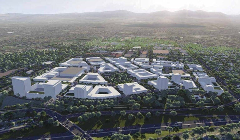
Photograph: Planners in fast-growing cities like Westminster, Colorado, where a new “downtown” is taking shape on the site of a former shopping mall, are increasingly integrating water usage into their work. Credit: City of Westminster.
References
Babbitt Center for Land and Water Policy. Forthcoming. “Incorporating Water into Comprehensive Plans in Colorado Communities.” Phoenix, Arizona: Lincoln Institute of Land Policy.
City of Flagstaff, Arizona. 2014. “Regional Plan 2030.” Amended 2018. https://www.flagstaff.az.gov/2945/The-Plan.
City of Westminster, Colorado. 2013. “Comprehensive Plan.” Amended 2015; update pending 2018. https://www.cityofwestminster.us/Portals/1/Documents/Government%20-%20Documents/Departments/Community%20Development/Planning/COMPLETE%20Comp%20Plan_2015%20Update_WEB.pdf.
Colorado Department of Natural Resources. n.d. “Drought Planning Toolbox.” Colorado Water Conservation Board (website). http://cwcb.state.co.us/technical-resources/drought-planning-toolbox/Pages/main.aspx.
Fedak, Rebecca, Drew Beckwith, Derek Hannon, Amelia Nuding, Russ Sands, Shelby Sommer, and Linda Stitzer. 2018a. Coordinated Planning Guide: A How-To Resource for Integrating Alternative Water Supply and Land Use Planning. Denver, Colorado: Water Research Foundation. http://www.waterrf.org/PublicReportLibrary/4623B.pdf.
———. 2018b. Integrating Land Use and Water Resources: Planning to Support Water Supply Diversification. Denver, Colorado: Water Research Foundation. http://www.waterrf.org/PublicReportLibrary/4623A.pdf.
Friends of the Verde River. 2017. “Local Land Use Planning Toolbox.” https://verderiver.org/local-land-use-planning-toolbox/.
Keystone Policy Center. 2018. “Colorado Water and Growth Dialogue Final Report.” (September). http://www.keystone.org/wp-content/uploads/2018/10/CO-Water-and-Growth-Dialogue-Final-Report_September-2018.pdf.
State of Colorado. 2015. Colorado’s Water Plan. (November). https://www.colorado.gov/pacific/cowaterplan/plan.