Climate Change
The national dialogue about rising waters tends to focus on coastal states like Florida and New York, with inland states largely absent from the conversation. But residents in Michigan, which has one of the longest coastlines in the continental U.S., are also contending with changes that are leading local officials to reexamine their coastal management policies. As climate change amplifies Lake Michigan’s natural fluctuations and brings increased storminess, communities are beginning to plan for an uncertain future.
Historically, for every decade or so residents have endured high waters, the next has brought retreating levels—and a wave of new lakeside development. This seesawing system, which can involve differences of up to six feet in water levels over the course of a few years, is masking a more gradual pattern of coastal erosion, according to Richard Norton, a professor of urban and regional planning at the University of Michigan. The focus on extremes, he said, has sidelined action on coastal management.
In 2014, Norton and a team of researchers started working with the City of Grand Haven and the Charter Township of Grand Haven, neighboring communities on the southeast perimeter of the lake, to think beyond current conditions and discuss best coastal management practices for the long term. At the center of their approach is a method called scenario planning.
Scenario planning allows communities to plan for an unpredictable future by exploring multiple possibilities of what could happen. The framework—which the Consortium for Scenario Planning, an initiative of the Lincoln Institute of Land Policy, promotes through technical assistance, educational resources, and a network of practitioners—has shown potential in these jurisdictions, which sit in one of the most politically conservative counties in the state and whose residents have varying views about the risks of climate change.
The Role of Local Planning
Local governments have a unique opportunity to help shape the future of coastal areas. While the National Flood Insurance Program influences private development, local governments make the majority of “public decisions that shape private development in high-risk coastal zones,” Norton and his coauthors write in a new article published in the Journal of the American Planning Association (Norton et al 2019).
However, few jurisdictions are fully embracing the role—about 40 percent of master plans from 60 Michigan Great Lakes communities studied didn’t include any discussion of coastal area management issues, according to research by Norton in the mid-2000s. At the time, three quarters of the plans hadn’t adopted any meaningful coastal area management policies.
A multi-disciplinary and multi-university team of researchers led by Norton wanted to see if scenario planning, a notoriously technical process, could be simplified and adapted to the context of municipalities that lack the technology and capacity to conduct extensive analyses. Funding for the project came from the Michigan Coastal Zone Management Program of the Department of Environment, Great Lakes, and Energy and is supported through a grant under the National Coastal Zone Management Act of 1972. The project was also supported by the nonprofit planning firm Land Information Access Association, which provides technical assistance to local leaders through its Resilient Michigan program.
Coastal management concerns are often edged out by factors including other planning issues, the role of coastal properties in providing property tax revenues, emotional attachments to properties, and resistance to government regulation, Norton said.
A few years ago, the team reached out to several towns, including the City of Grand Haven and Grand Haven Charter Township, to discuss the possibility of embarking on a consultant-led scenario-planning process. At the time, both communities were in the middle of updating their master plans. Like most of the state’s 122 jurisdictions on Lake Michigan, the two communities have small populations with limited staff capacity.
An extended planning process ensued. From 2014 to 2016, local officials, planning commissions, city council and township board, and residents from the two places took part in over 20 working meetings and presentations.
Weighing Scenarios
Norton discussed the details of the project at the annual conference of the Consortium for Scenario Planning. Central to the process was the identification of three “climate futures.” Researchers created the scenarios, based on a 20- to 50-year planning horizon, by using easily available data, including historic water level data and FEMA maps, and basic GIS analysis. In the “lucky” future, water levels remain low and the community experiences one 50-year storm (as classified by FEMA). The “expected” future assumes average water levels and one 100-year storm. The “perfect storm” scenario is characterized by high water levels and a 500-year storm.
“The process helped people understand that we weren’t just looking at the worst-case scenario,” Jennifer Howland, community development manager for the City of Grand Haven, said.
As a next step, the cross-sector team drew on a variety of off-the-shelf data related to planning and development to outline three options for how the local governments could respond in each climate future. In one scenario, the governments maintained existing structures. In a second, residents were permitted to build out based on what current zoning allows. A third option incorporated a series of best management practices (BMPs), ranging from setbacks in nearshore zones to restrictions on building within wetlands. Combining the climate futures and management options, the researchers presented nine scenarios for local officials and residents to consider. They shared the fiscal, environmental, and land use impacts of each scenario.

In the City of Grand Haven’s “lucky” future, for example, if residents continue to build out under current zoning regulations, 207 structures will be damaged. If residents adopt BMPs, this number falls to 59.
A “lucky” future in which the Township builds out under the current zoning regulations results in $11.6 million in potential damages in areas that currently house properties bringing in $194,015 in net annual revenue. In the “perfect storm” scenario, building out under current zoning regulations results in $89 million in potential damages in areas that hold properties bringing in $358,000 in annual tax revenue.
Researchers also calculated the discrepancy between the land area designated as high-risk erosion areas by the state and the land area that they calculated would be inundated in the three climate futures. The land area identified by the state was much smaller than the land area identified as high-risk areas by researchers, highlighting the important role these local governments can play in filling the gap.
“When we first presented the materials, there were looks of shock and surprise, but once people processed the information and understood that these are reasonable futures we should be thinking about, there was less opposition,” Norton said. “If we had just gone straight to announcing setbacks, that would have been hugely controversial.”
Local officials also used other strategies to help the conversations along. Howland emphasized that science-based maps and aerial images of historic shorelines made the analysis more poignant for residents. Stacey Fedewa, community development director for Grand Haven Charter Township, said focusing on the weather-related impacts of climate change was an effective way to bring the global issue to the local level.
“If we flood from a big storm, we will be without power, the roads will be flooded, the businesses will be shut down,” Fedewa said. “Trucks wouldn’t be able to enter. If we are able to bounce back faster by being resilient, businesses shut down less, employees come back to work sooner than they would have otherwise.”
The sessions were also important in demonstrating that building close to the shore and using armoring measures such as seawalls and riprap can create long-term damage to natural beaches. This “stop nature” inclination, as Norton calls it, is exacerbating erosion of adjacent beaches and contributing to the annual foot of shoreline erosion in high risk erosion areas.

In their resulting master plans, the two jurisdictions incorporated recommendations from the process to varying degrees. The body of the City of Grand Haven Master Plan includes regulatory and infrastructure policies recommended by the researchers. The city also updated its sensitive areas overlay district and added a beach overlay district based on the aerial images presented by the researchers that show the high water mark changing over time. It created strict rules for armoring lakeward of the line established by the beach overlay district: no shoreline protection measure can be installed within this area, with the exception of specific types of seasonal temporary fencing (City of Grand Haven 2016). A new homeowners guidebook helps property owners understand what they can do and provides alternatives (LIAA 2018).
In the township, the planning director and commission included conceptual overviews and policy recommendations in the body of their plan, but chose to relegate the more detailed analyses to the plan’s appendix out of concern about resistance in the politically conservative community (Grand Haven Charter Township 2016). The township also considered new proposals to prohibit seawalls—which can interrupt natural sediment transport processes, creating larger waves and more erosion that wears down the walls over time—and to increase the setback for new construction to 200 feet from the high ordinary water mark, a significant change from the current 50-foot setback. The proposals did not pass—in part because officials were focused on taking steps to protect homes from record high water levels this fall—and regulatory decisions will remain with the current authority, the Michigan Department of Environment, Great Lakes and Energy.
“Water levels will go back down again,” Norton said. “They always have. So how can we help town officials keep this on the agenda when there is not a crisis?”
Scaling the Approach
Norton believes scenario planning is a promising tool for local decision making and thinks the fact that these governments incorporated coastal management policies in their master plans is an important step. “The simplicity of the methods is helpful,” he said. “They are focused on decisions: should they adopt setbacks or not?” Norton does acknowledge that even this simplified method typically requires some in-house expertise, such as the ability to manipulate ArcGIS.
He hopes some of the lessons learned, about both scenario planning and shoreline management, can be applied in other communities, ideally with the help of outside consultants who can provide the analysis needed at a reasonable cost or without the need for outside consultants at all. And word does seem to be spreading in the region: Howland has shared the city’s work with neighboring communities along the lake and presented at a dune symposium in East Lansing. Fedewa has encouraged Spring Lake township, north of Grand Haven, to utilize the resources of the Resilient Michigan program.
Norton, who now plans to expand his work to nearby Lake Huron, said scenario planning is an ideal tool to prepare for the uncertainty inherent in an age defined by rising waters, no matter what type. “What we are doing is very applicable in ocean coastal settings too.”
This article was published in the print edition of the July 2020 issue of Land Lines with the title “Great Lakes Communities Use Scenario Planning to Prepare for Rising Waters.”
To learn more about how scenario planning can help communities prepare for the future, read “Scenario Planning in a Pandemic: How to Embrace and Navigate Uncertainty.”
Emma Zehner is communications and publications editor at the Lincoln Institute of Land Policy.
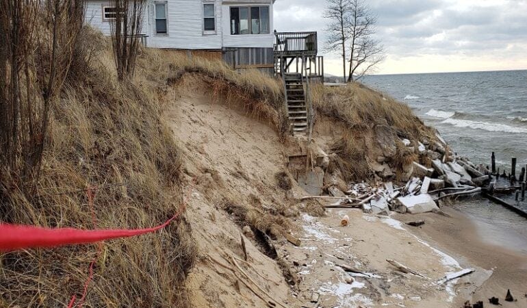
Lead Photograph: A house in Grand Haven Charter Township sits precariously close to the shore in December 2019, following several months of intense storms. Credit: Grand Haven Charter Township.
References
City of Grand Haven. 2016. City of Grand Haven 2016 Master Plan. Grand Haven, MI. https://grandhaven.org/residents/grand-havenmaster-plan/.
Grand Haven Charter Township. 2016. Grand Haven Charter Township 2016 Master Plan: Executive Summary. Grand Haven Township, MI. http://www.ght.org/wp-content/uploads/master-plan/ExecutiveSummary.pdf.
LIAA (Land Information Access Association). 2018. Living in Sensitive Areas: A Homeowners Guide for Residents of Grand Haven. Grand Haven, MI: City of Grand Haven. May. https://grandhaven.org/living-in-sensitive-areas-homeowners-guide/.
Norton, Richard K., Stephen Buckman, Guy A. Meadows, and Zachary Rable. 2019. “Using Simple, Decision-Centered, Scenario-Based Planning to Improve Local Coastal Management.” Journal of the American Planning Association. 85 (4): 405–423. https://www.tandfonline.com/doi/full/10.1080/01944363.2019.1627237.