City Tech
Land readjustment is a vital but difficult and time-consuming process: formulating a sort of retroactive version of planning in neighborhoods that developed informally, with unsanctioned dwellings chaotically built in ways that leave some with no access to streets and paths. According to UN-Habitat, 863 million people around the world lived in such settings as of 2014, and the number could rise to 3 billion by 2050. The agreed draft of the New Urban Agenda for the Habitat III conference in Quito, Ecuador, notes that the “rising number of slum and informal settlement dwellers” contributes to intense challenges that exacerbate global poverty and its risks, from a lack of municipal services to increased health threats.
But evolving technology may facilitate revision of these organic layouts in ways that lead to minimal displacement and speed the absorption of such neighborhoods into a city’s formal structure, thus providing residents basic services—from sanitation and drainage systems to access for fire and medical emergencies. One of the more promising tools is Open Reblock, a platform currently in a pilot phase in areas around Cape Town, South Africa, and Mumbai, India. The project stems from a collaboration among Shack/Slum Dwellers International (SDI, is a network of urban-poor communities in 33 countries), the Santa Fe Institute (SFI, a nonprofit research and education organization), and Arizona State University.
SDI has long been involved in grassroots “reblocking”—essentially another way of characterizing the land-readjustment process. Luís Bettencourt, a professor of complex systems at the Santa Fe Institute, explains that his group, which focuses on “cities as systems,” began working with SDI a few years ago. There was a useful convergence in the high-level, statistics-and-data thinking of the SFI group with the on-the-ground “census” efforts SDI used in its work with informal-settlement communities.
SDI’s reblocking efforts could be painstaking. Residents led the process of mapping a neighborhood—on paper. Then they gathered at community meetings, arranged cutouts representing every local structure over that map, and began shifting them around to devise new paths and roadways. While this active collaboration was profoundly beneficial, the analog methodology wasn’t exactly speedy.
Ever-more-accessible digital technology has in recent years eased the process, says SDI Programme Officer: Data Management Anni Beukes. The group now uses a geographic information system (GIS) tool to map settlement boundaries and services available, and then relies on a separate tool for detailed household-level surveys and precise measurements of every structure. Given the wide availability of mobile devices, the process is open to—and indeed dependent on—direct resident participation.
Enrique R. Silva, research fellow and senior research associate at the Lincoln Institute, notes that similar tech-mapping tools are impacting such efforts around the world. “You can map something almost immediately,” he says, and involve community members in that process. He points to efforts, backed by the Lincoln Institute and others, that rely on “cheap and universal” devices and crowd-sourcing tools to reach similar goals across Latin America.
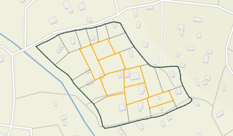
A master map that is available in digital form also creates new possibilities. Open Reblock is an example. It deploys a custom algorithm to read a digital map of an informal settlement and propose what it sees as the optimal strategy for reblocking it. (The algorithm is written to prioritize existing roadways and structures, echoing the traditional goal of minimizing displacement.) This process takes just minutes, at most.
“When I first showed it to our communities, they said, ‘You’re taking our paper cutouts away’!” Beukes says with a laugh. They weren’t wrong—and they weren’t actually protesting. (“At least the younger ones weren’t; some older participants,” she adds, “can be hesitant in their uptake of new technology.”)
But what Open Reblock produces is not meant to be a strict directive or an end point—community members can still tweak the results based on their direct knowledge and concerns. Indeed, Open Reblock depends on such participation—“creating a shared reality where people can play and create this future reality,” Bettencourt says. “It’s basically a town-planning tool, at the level of a neighborhood.” And by offering “a proof of principle and a starting point” for negotiations, he adds, it radically speeds up one of the toughest steps in the process.
Beukes says participants in the pilot programs have reacted with enthusiasm toward the new possibilities of this system. It means that a final plan will exist in a form that city officials can respond to more easily, and it ensures that all parties are considering the same geospatial data and planning scheme. “It’s a template for discussion,” Bettencourt adds, one that “puts everyone literally on the same map.”
With a grant from Open Ideo, Bettencourt’s team and SDI are working to improve the design of Open Reblock’s interface, with feedback from community participants in Cape Town and Mumbai. The entire project is being created in open-source code (available on Github), both to encourage improvements from anyone who wants to be involved and to make it easier to scale up future versions for widespread use anywhere.
The project is, of course, not a magic solution. Land readjustment can be contentious, and Silva points out that important issues around the value of any given settlement dweller’s property must still be worked out on a more individual, human level. Bettencourt and Beukes agree that Open Reblock is a supplement to, not a substitute for, existing processes.
Still, Bettencourt points to UN-Habitat numbers to speculate that there may be a million neighborhoods around the world in need of reblocking. “That’s a scary number,” he says. And it adds to the sense among some observers that there’s just something impossible about the effort—particularly when, on a case-by-case basis, the process gets bogged down over time.
But all this may be less intimidating from a technologist perspective. Think of the mapping and data-collection tools that have emerged in recent years as an early step that builds on the long-existing work of SDI and others. Open Reblock is just one more iteration of that trajectory. “I think we have all the ingredients, but we have to start doing,” Bettencourt says. “If there’s a system to capture the data and run proposals on top of it, that’s a big step. It doesn’t create the change, but it helps.”
Rob Walker (robwalker.net) is a contributor to Design Observer and The New York Times.
Leaflet | Map data © OpenStreetMap contributors, CC-BY-SA, Imagery © Mapbo