Established in 2020, the Center for Geospatial Solutions (CGS) is a self-sustaining nonprofit enterprise operating out of the Lincoln Institute of Land Policy. We are a nonprofit data solutions provider, working with external partners to transform how land, water, and social resources are managed and protected.
At CGS, we believe that better decisions—about housing, infrastructure, conservation, and community well-being— depend on better data. That’s why we specialize in building modern, integrated, and actionable geospatial systems for the public good. We approach this work with a commitment to objectivity and service, and our work helps federal agencies, state and local governments, nonprofits, and regional and national networks access the tools and insights they need to tackle complex challenges.
We are more than technologists. We are systems thinkers, designers, data scientists, and community collaborators. Our strength lies in helping mission-aligned organizations use data not just to understand the world—but to change it.
Mission and Vision
CGS was founded to enable data-driven decisions for the greater good of land, water, and people. Our expert team improves how data is accessed, interpreted, and applied to help changemakers big and small fulfill their purpose. We envision a world where new technologies—like remote sensing, AI, and geospatial analysis—are used to realize swift and fair outcomes for people and the planet.
The Nature Conservancy of Canada (NCC) is the leading land conservation organization in Canada. Since 1962, the nonprofit and its partners have helped protect more than 35 million acres (14 million hectares) across Canada. NCC is working with us to develop a long-term technology strategy that streamlines data collection and management across the organization and allows all of its programs to leverage the latest technology to improve conservation prioritization, securement, and management. This strategy is helping reduce the time it takes staff to effectively manage properties and communicate key metrics to outside partners and funders. Access to better technology is also making it easier for NCC to effectively leverage new revenue sources, such as carbon offsets, by quantifying and capitalizing on the ecological benefits of land conservation.
Enabling Better Decisions About Land, Water, and People
At our core, CGS helps partners make better, more informed decisions about how land, water, and other resources are used, governed, protected, and shared. We ensure that data is a decision-making asset—not just a technical resource.
Our clients and collaborators rely on us to translate complex challenges into achievable solutions that are grounded in real-world goals and community values.
“The Center for Geospatial Solutions is moving the global environmental field forward to meet ambitious goals set forth by scientists to save and restore our planet.”
Water in the West—one of the most enduring and confounding stories of human settlement anywhere around the world.
Jim Holway, who retired as director of the Babbitt Center for Land and Water Policy this summer, has spent more than 40 years helping to solve the puzzle of ensuring sustainable water resources in this increasingly arid region. In the latest Land Matters podcast, he describes the challenges ahead, and the kind of leadership—and serious, good-faith negotiation—it will take to establish a more secure water future.
With some places having their water restricted, and big reservoirs like Lake Mead drawing down to historically low levels, it has become increasingly clear that water from the Colorado River—distributed to nine states in the US and Mexico through a series of agreements and amendments hammered out since the 1920s—is no longer enough to meet the demands of a fast-growing population.
How did the region get to this point? “I’d say it was a combination of optimism, beginning with allocating more water [than would be available], and then it was just ignoring science for political reasons,” said Holway. “If I want to get my water project approved, it’s going to be a lot easier if I can convince people there’s enough water left for their project too. Even once we should have known better, we acted like we didn’t know better.”
The water allocations now have a structural deficit, Holway said, that is clear throughout the year-to-year ups and downs of drought and sufficient snowpack. Climate change is intensifying everything.
“We designed a hydrologic system for a physical reality that is changing on us, and the change in the level of heat is driving the system. More evaporation and more demand for agriculture, more demand in urban use—that heat is actually a more significant factor than precipitation. Whereas there is a lot of uncertainty about what the future precipitation changes will be in the Southwest, it’s very clear that it’s going to be hotter.”
While politicians debate climate science, Holway says, water and land managers know they have no choice but to prepare for the uncertain future that climate change will bring: “Droughts that cause inadequate supplies for historic uses, floods that exceed the infrastructure we’ve built to handle flooding, wildfires of much greater intensity and size, urban areas that are getting increasingly hot and leading to crisis situations in the middle of the summer—this is the reality of our future, and we need to adapt to deal with it.”
Building the capacity of local communities to integrate land use planning and the management of water resources has been the calling card of the Babbitt Center under Holway’s tenure, including using scenario planning techniques to map out future supply and demand conditions. Importantly, agriculture—which uses approximately three-quarters of Colorado River water—has increasingly been at the table, Holway said.
When asked to look to the future, Holway said, “It’s important for anyone doing this kind of work to find some way to sustain themselves. I suspect the thing that makes me most optimistic is when I look at the 20- and 30-year-olds getting involved . . . it seems that they really have an understanding of the challenges they’re inheriting.”
One of those challenges is developing the capacity to work together as a civilization to address water shortages in a more serious and straightforward manner, he said.
“When societies fail, it may look like it’s because of a flood, a drought, disease, or warfare. However, societies have survived those challenges before. Why do they not survive the next one? Typically, what we find is they have lost the ability to govern themselves.
“To me, that is where my main pessimism comes from. It isn’t our water challenge. It’s, will we come together? Will we make the necessary decisions we need to govern ourselves? That is our biggest challenge, and it’s what we’re doing particularly badly at the moment.”
Water, Holway said, “perhaps will help us rediscover our ability to come together and make collaborative decisions. There are very few things that humans see as critical to their survival [more than] a good water supply. That’s pretty clear and pretty compelling. Let’s hope it’s part of our path forward.”
Jim Holway served as director of the Babbitt Center for Land and Water Policy from its founding in 2017 until late 2023. He was elected to the board of the Central Arizona Water Conservation District, directed the Western Lands and Communities program with the Sonoran Institute, and served as a professor of practice in sustainability at Arizona State University and assistant director at the Arizona Department of Water Resources. He has degrees from Cornell University and the University of North Carolina, and was inducted into the College of Fellows of the American Institute of Certified Planners.
The sustainability of water and land resources is one of the greatest challenges facing the Colorado River Basin. Since most land use requires an adequate water supply, meaningfully addressing this challenge requires recognizing how land use decisions shape water demand. This link is the cornerstone of the Babbitt Center for Land and Water Policy, a center at the Lincoln Institute of Land Policy.
Building Capacity to Secure Our Water Future
Land use decisions that shape our water future are made every day. And a thriving, sustainable future in the West requires that communities integrate land and water policy decisions. The Babbitt Center seeks to advance the integration of land and water management to meet the current and future water needs in the Colorado River Basin. Our efforts will advance water sustainability and resilience in the Colorado River Basin, throughout the West, and ultimately throughout the world.
Watch the Babbitt Center signature video to learn more about our approach to solving water management and land use integration challenges.
Our Work
Real-world understanding, research and training, and collaborative partners who share resources are valuable catalysts that strengthen a community’s ability to secure its water future. Our work is focused throughout the seven Colorado River Basin states, binationally across the basin into Mexico, and with 30 Native American tribes, boosting communities’ resilience and building a global exchange of transformative ideas with other arid and semiarid regions.
Integrating land use and water management requires innovative approaches and partnerships. The Babbitt Center works closely with governmental organizations, nongovernmental organizations (NGOs), academic institutions, and business leaders to address challenges and harness opportunities. We conduct research and develop tools, promote best practices, provide training, and facilitate partnerships to guide decision-making for sustainable management of land and water resources.
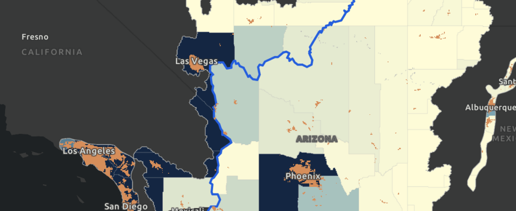
Colorado River Basin Map
The Babbitt Center for Land and Water Policy produced an updated Colorado River Basin Map in partnership with the Center for Geospatial Solutions. This map showcases the geography and hydrography of the Colorado River Basin, corrects inconsistencies in contemporary maps of the region, and provides water managers, tribal leaders, educators, and other stakeholders with an updated resource as they confront critical issues related to growth, resource management, and sustainability.
Historically, planning for water resources and land use have been conducted separately. Yet, where and how we build greatly impacts water supply and demand and the quality of water that supports our ecosystems. The Growing Water Smart program helps community leaders integrate water and land use planning to further the sustainability and resilience of their community. Multidisciplinary community teams of key decision-makers and personnel, such as elected officials, planning commissioners, water resource managers, land use planners, and economic and community developers, come together in facilitated work sessions to: 1) set a workshop intention, 2) evaluate current water smart policies and practices, 3) develop community water efficiency goals, 4) make the case for water smart change in their communities, and 5) create a team action plan that identifies tasks and timelines for meeting the community’s water efficiency goals.
The Hardest-Working River in the West: A StoryMap of the Colorado
Explore the key water sustainability issues in the Colorado River Basin through data and stories updated regularly. Although not the largest or longest river in the world, the Colorado River connects a rich array of social and ecological communities along its 1,450-mile journey from its headwaters in the Rocky Mountains of Colorado to its mouth in the Gulf of California, Mexico.
Sowing Seeds: How Scenario Planning Can Help Agricultural Communities Build a Resilient Future
In March 2023, a consortium of Mesa County, Colorado, residents gathered to use a process called exploratory scenario planning, or XSP, to envision a more resilient future for their community and agricultural economy. The Mesa Conservation District hosted the workshop, developed by the Babbitt Center in partnership with Lincoln Institute’s Scenario Planning team and Arizona State University’s Arizona Water Innovation Initiative. XSP helps communities plan for an uncertain future by exploring multiple possibilities of what might happen. The practice helps planners, community members, and other stakeholders consider various futures and how to effectively plan with various driving forces at play. XSP encourages a wide range of perspectives and brings diverse voices into the discussion to help create plans that community leaders and stakeholders can implement.
Perspectives from the Field: The Future of Agriculture
The Colorado River is pivotal in supporting agricultural production throughout the basin, not only contributing significantly to the economies and livelihoods of rural communities but also supporting our national food supply and global food security.
This two-page summary synthesizes the findings of the Babbitt Center report “Agriculture in the Colorado River Basin States: Challenges and Implications for the Future,” which explores the main issues farmers and ranchers in the region face due to weather and water supply changes, and how insights from those most impacted can be used to craft effective solutions.
A StoryMap Exploring the Colorado River Through Data
Although not the largest or longest river in the World, the Colorado River is known for its many legacies. The Babbitt Center for Land and Water Policy developed a StoryMap about the Colorado River, its tributaries, and the lands upon which communities, economies, and the environment depend. It is also about the places, people, and policies that have shaped water and land management and planning in the past and will continue to shape decisions about how we use, share, and conserve these finite resources today and in the future. With a widening gap between supply and demand, the water resources upon which land use, planning, and development depend are more vulnerable than ever.
The Babbitt Center has created an Esri ArcHub open data portal that contains the data, maps, and related reports seen or mentioned in The Hardest Working River in the West StoryMap. This allows individuals to download and explore the data for themselves.
Land and water policy is at the heart of climate policy and essential to climate-resilient development. Lincoln Institute staff are participating in the UN’s 28th annual Climate Change Conference (COP28) in Dubai, United Arab Emirates, from November 30 to December 12, to support inclusive and equitable land and water policy responses to the climate crisis.
Lincoln Institute at the Multilevel Action and Urbanization Pavilion
This year, the Lincoln Institute is a Pavilion partner at the Multilevel Action and Urbanization Pavilion, coconvened by ICLEI–Local Governments for Sustainability and UN-Habitat. The Pavilion serves as the global hub for discourse on challenges and solutions to the interconnected issues of climate change and urbanization. Here the Lincoln Institute will focus on the intersection of equitable climate action, land use, urbanization, nature-based solutions, and finance in two sessions on the Global Event Stage and streamed live on YouTube:
Local Solutions in Land: Multilevel Collaboration for Inclusive Climate Resilience
December 6 at 10:00 a.m. (GMT+4)
This event will highlight the critical role land and land policy can play in the development of inclusive, resilient communities and how collaboration and networks are essential to scaling up action. Anacláudia Rossbach, director of the Latin America and the Caribbean program at the Lincoln Institute, will moderate. Panelists include:
Patrick Welch, policy analyst, Lincoln Institute of Land Policy (moderator)
Lauren McLean, mayor of Boise, Idaho
Inamara Mélo, general coordinator of adaptation, national secretariat for climate change, Brazilian Ministry of Environment and Climate Change
Margaret Mengo, director of program operations in Africa, Habitat for Humanity International
Laura Arévalos, community liaison and professor, Villa 20, Buenos Aires, Argentina
Juan Carlos Cárdenas, mayor of Bucaramanga, Colombia
Toward Win-Win Outcomes for Climate and Community
December 9 at 1:00 p.m. (GMT+4)
This event will focus on how communities—from agricultural to highly urbanized—are taking action to reduce and adapt to climate change while balancing their responses with social and economic considerations. Panelists include:
Amy Cotter, director of climate strategies, Lincoln Institute of Land Policy
John Farner, executive director, Babbitt Center for Land and Water Policy
Deepthy Kanneri Balagangadharan, regional director Middle East, Green Business Certification, Inc.
Henk Ovink, senior fellow, World Resources Institute, and commissioner, Global Commission on the Economics of Water
Perla Lozano, manager, Tecnológico de Monterrey’s Center for the Future of Cities
Gabriel Liu, joint secretary at the Brazilian Presidency for Environment, Climate and Agriculture
Hosted by the Lincoln Institute
USG-Civil Society Gathering on Built Environment Day
December 6 at 5:00 pm (GMT +4)
Hosted by the Lincoln Institute of Land Policy, this meet-and-greet reception brings together representatives from the US Department of Housing and Urban Development (HUD) and US civil society organizations attending COP28 to discuss the critical intersections of climate, housing, transport, and the built environment in a relaxed environment.
US Government staff and members of US civil society organizations are invited to RVSP here.
Featuring the Lincoln Institute
Lincoln Institute staff will be featured in several other discussions at COP28, including:
Building Partnerships to Deliver Transformative Climate Action in Cities
December 1
Hosted by The King’s Foundation and Community Jameel, this impact-driven roundtable acknowledges the Declaration on Sustainable Urbanisation and leverages insights from Abdul Latif Jameel Poverty Action Lab (J-PAL) and The Prince’s Foundation’s University of Oxford-partnered research to build partnerships, raise awareness and explore evidence-based solutions towards climate action in cities.
Achieving Climate Targets in the Transport Sector: Can Renewables Pave the Way?
December 5 at 11:30 a.m. (GMT +4)
Co-developed by Asociación Sustenar, the International Union of Railways, the International Union of Public Transport, and REN21, this panel will discuss how renewables and transports can tackle global climate goals together.
Land Use in the Era of Climate Mobility: The Possibilities, Challenges, and Risks of Artificial Intelligence
December 6 at 9:00 a.m. (GMT +4)
Organized by the Global Centre for Climate Mobility and Claudia Dobles (LCAU/MIT), this panel will discuss the challenges and opportunities of introducing AI into land use planning in climate vulnerable countries and communities and its potential for helping to address climate mobility pressures in rural and urban areas.
Detalhes
Data(s)
Novembro 30, 2023 - Dezembro 12, 2023
Idioma
inglês
Palavras-chave
Adaptação, Mitigação Climática, Resiliência, Água
Feed the Farm, Not the Algae
By Jon Gorey, Novembro 1, 2023
SHARE
Natural ecosystems offer some powerful solutions to our climate crisis. And nature holds answers to other environmental challenges as well—like figuring out how to feed a growing human population without contributing to climate change, pollution, and toxic algal blooms.
The invention of synthetic fertilizer allowed farmers to double their yields per acre in the past century, supporting some four billion additional humans. But its use and production can have serious ecological impacts. Along with methane from livestock and the carbon released by soil disturbance, fertilizer is a primary reason why agriculture accounts for about 10 percent of greenhouse gas emissions in the US. But new funding models in the Midwest are providing an incentive to farmers to swap status quo techniques for more sustainable practices.
The high-temperature production of synthetic nitrogen fertilizer is by itself responsible for 1.4 percent of global carbon emissions. After that fertilizer is applied to crops, it can release nitrous oxide, a greenhouse gas 245 times more potent than carbon dioxide. And excess nitrogen also finds its way into waterways, polluting drinking supplies and wildlife habitat and, in the American Midwest and Plains, flowing down the Mississippi River to create a vast, headline-making “dead zone” in the Gulf of Mexico, where it feeds toxic algal blooms that suck the oxygen out of the water.
“That is the principal cause of these dead zones and toxic algal blooms in the Gulf of Mexico,” says Jim Levitt, director of the International Land Conservation Network at the Lincoln Institute of Land Policy. “The Mississippi River collects fertilizer runoff from Montana all the way to Pittsburgh, and sends it down in one big spout that flows into the Gulf of Mexico, and it becomes this concentrated soup of nitrogen and phosphorus.”
However, some fairly simple practices can reduce how much fertilizer farmers need, and how much ends up polluting watersheds. First and foremost, says Matthew Helmers, director of the Iowa Nutrient Research Center at Iowa State University, is resisting the tendency to over-fertilize. About a third of farmers apply more nitrogen than necessary, sometimes in an effort to maximize yields or hedge against risk.
“If we can reduce the rate, and not reduce yields for the crop,” he says, that cuts nitrogen loss as well as costs for the farmer. Iowa State and other universities developed a calculator to help Midwestern farmers determine the best amount of nitrogen to use depending on their goals. And simply fertilizing in the spring instead of in the fall can also reduce nitrogen runoff by an average of 6 percent.
Beyond better fertilizer management, regenerative farming—a more holistic and sustainable approach to agriculture that can help restore degraded soil, enhance biodiversity, and protect water and other resources—can also help reduce nitrogen runoff.
One of the most basic regenerative farming practices is planting cover crops in between growing seasons. “That’s where we try to have something green out there during the period when we’re not growing our cash crop,” Helmers says, “covering the soil surface and taking up nutrients that might otherwise be susceptible to loss.”
A perennial cover crop such as rye or oat stabilizes the soil, but also converts excess water-soluble nitrate into plant matter, “so there’s less nitrate that could be leached away in the next rainfall event,” Helmers explains. Rarely employed just 30 years ago, the use of cover crops nearly doubled in Iowa between 2017 to 2021, to an estimated 2.8 million acres.
Other in-field practices include a diverse crop rotation—alternating corn or soybean seasons with forage crops, for example—or growing an energy crop such as switchgrass, which can be used to produce renewable natural gas. (That may sound like gas-powered greenwashing, but it’s a real technology.) Low- or no-till farming, meanwhile, which reduces soil disturbance and leaves most of the plant residue on the surface after harvest, can cut nitrous oxide emissions and help soil retain more carbon and nutrients. No-till farming is now employed on 41 percent of Iowa farmland, or 9.5 million acres.
No-till farming minimizes soil disturbance, helping soil retain more carbon and nutrtients. Credit: Jason Johnson, USDA Resources Conservation Service.
The edge of a farm offers one more chance to halt nitrogen loss as water drains off the cropland and into nearby waterways. “We have a whole suite of practices to treat that water before we deliver it to a stream, and they’re kind of utilizing Mother Nature to promote denitrification,” Helmers says, referring to the natural process that converts nitrate into dinitrogen, the inert, stable gas that makes up most of Earth’s atmosphere.
In one configuration, underground drainage systems can be diverted so they release water perpendicular to a stream instead of directly into it, forcing it to flow slowly across a 30-foot vegetated buffer. If the soil in that buffer zone doesn’t contain enough organic matter to promote denitrification, then installing a bioreactor—which sounds high-tech, but is simply a trench full of wood chips—can help do the job. These simple methods can reduce nitrate loss by 42 percent or more.
“We could also route that drainage water to a wetland—that might be a riverine wetland next to the stream, or an oxbow wetland, or one that we restore,” Helmers says. In addition to providing ecological benefits to the landscape, “those can be very effective for promoting denitrification.”
Despite the impact of nitrates on both local drinking water and the Gulf’s marine environment, these practices remain voluntary in Iowa and in most other states. But there are federal and local cost-share programs designed to encourage their adoption, some more robust than others.
Iowa’s Polk County, for example, offers both financial and logistical assistance for installing edge-of-field buffers, making it easier and more economical for farmers who might otherwise be put off by the hassle or cost. And since water treatment plants are finding that it’s more efficient to pay farmers to reduce fertilizer runoff at the source than to build additional treatment facilities, new funding models have emerged that encourage more farmers to introduce conservation measures to their land.
The multistate Soil and Water Outcomes Fund, for example, pays farmers to create vegetative buffers, plant cover crops, or employ other regenerative agriculture techniques chosen by the farmer. Later in the year, an independent scientific team measures and verifies the reduction in nitrogen or increase in stored soil carbon. The fund then sells a mix of environmental credits to various public and private entities seeking to meet required or voluntary sustainability goals. Water quality credits, for example, allow water treatment facilities subject to strict nutrient reduction standards to fund pollution mitigation at the source instead of paying for expensive new equipment. Carbon offsets, meanwhile, are tied to the amount of additional carbon stored in the soil.
Importantly, given the growing and valid criticism aimed at carbon offset schemes, those credits are tied to actual outcomes, “after they have been produced and verified,” says Eric Letsinger, CEO of Quantified Ventures, whose AgOutcomes subsidiary jointly manages the fund with the Iowa Soybean Association. The outcomes-based model is “a demonstrably more cost-effective means of achieving environmental improvements than existing ‘pay for practices’ approaches,” he adds, in a paper prepared for the Environmental Defense Fund.
“Basically the sewage treatment plant pays into a fund, and the fund will contract with soybean farmers to manage their land in a different way, so as to reduce the amount of phosphorus and nitrogen that reaches the streams,” Levitt explains. “That’s a natural climate solution that is applicable to the entire Mississippi River Valley, and will clean up the water more efficiently than building engineered filters into the streams of Guttenberg, Iowa, or Des Moines.”
In 2021 and 2022, the Soil and Water Outcomes Fund expanded from Iowa into eight more states, and paid farmers an average of $31 per acre to implement new conservation measures on over 241,000 acres of cropland. Those practices prevented 3.4 million pounds of nitrogen and 206,000 pounds of phosphorus from reaching waterways, and sequestered over 465 million pounds of carbon.
Still, there’s a lot more ground to cover—literally—including millions of acres in Iowa alone. Cultural barriers remain, with some longtime farmers wary of deviating from a proven formula.
“We need to get over that hump of changing what’s the norm,” Helmers says, perhaps hinting at the most powerful untapped nature-based solution of all: human nature. “We still need to create a sense of urgency—that we have a problem, and we need to do something about it.”
Jon Gorey is a staff writer at the Lincoln Institute of Land Policy.
Lead image: This map illustrates how runoff from farms (green areas) and cities (red areas) drains into the Mississippi River, delivering nutrients into the Gulf of Mexico and fueling the annual hypoxic zone. Credit: NOAA.
Land Matters Podcast: Water in the West
Jim Holway Reflects on Decades of Problem-Solving
By Anthony Flint, Outubro 31, 2023
SHARE
Water in the West—one of the most enduring and confounding stories of human settlement anywhere around the world.
Jim Holway, who retired as director of the Babbitt Center for Land and Water Policy this summer, has spent more than 40 years helping to solve the puzzle of ensuring sustainable water resources in this increasingly arid region. In the latest Land Matters podcast, he describes the challenges ahead, and the kind of leadership—and serious, good-faith negotiation—it will take to establish a more secure water future.
With some places having their water restricted, and big reservoirs like Lake Mead drawing down to historically low levels, it has become increasingly clear that water from the Colorado River—distributed to nine states in the US and Mexico through a series of agreements and amendments hammered out since the 1920s—is no longer enough to meet the demands of a fast-growing population.
How did the region get to this point? “I’d say it was a combination of optimism, beginning with allocating more water [than would be available], and then it was just ignoring science for political reasons,” said Holway. “If I want to get my water project approved, it’s going to be a lot easier if I can convince people there’s enough water left for their project too. Even once we should have known better, we acted like we didn’t know better.”
The water allocations now have a structural deficit, Holway said, that is clear throughout the year-to-year ups and downs of drought and sufficient snowpack. Climate change is intensifying everything.
“We designed a hydrologic system for a physical reality that is changing on us, and the change in the level of heat is driving the system. More evaporation and more demand for agriculture, more demand in urban use—that heat is actually a more significant factor than precipitation. Whereas there is a lot of uncertainty about what the future precipitation changes will be in the Southwest, it’s very clear that it’s going to be hotter.”
While politicians debate climate science, Holway says, water and land managers know they have no choice but to prepare for the uncertain future that climate change will bring: “Droughts that cause inadequate supplies for historic uses, floods that exceed the infrastructure we’ve built to handle flooding, wildfires of much greater intensity and size, urban areas that are getting increasingly hot and leading to crisis situations in the middle of the summer—this is the reality of our future, and we need to adapt to deal with it.”
Building the capacity of local communities to integrate land use planning and the management of water resources has been the calling card of the Babbitt Center under Holway’s tenure, including using scenario planning techniques to map out future supply and demand conditions. Importantly, agriculture—which uses approximately three-quarters of Colorado River water—has increasingly been at the table, Holway said.
When asked to look to the future, Holway said, “It’s important for anyone doing this kind of work to find some way to sustain themselves. I suspect the thing that makes me most optimistic is when I look at the 20- and 30-year-olds getting involved . . . it seems that they really have an understanding of the challenges they’re inheriting.”
One of those challenges is developing the capacity to work together as a civilization to address water shortages in a more serious and straightforward manner, he said.
“When societies fail, it may look like it’s because of a flood, a drought, disease, or warfare. However, societies have survived those challenges before. Why do they not survive the next one? Typically, what we find is they have lost the ability to govern themselves.
“To me, that is where my main pessimism comes from. It isn’t our water challenge. It’s, will we come together? Will we make the necessary decisions we need to govern ourselves? That is our biggest challenge, and it’s what we’re doing particularly badly at the moment.”
Water, Holway said, “perhaps will help us rediscover our ability to come together and make collaborative decisions. There are very few things that humans see as critical to their survival [more than] a good water supply. That’s pretty clear and pretty compelling. Let’s hope it’s part of our path forward.”
Jim Holway served as director of the Babbitt Center for Land and Water Policy from its founding in 2017 until late 2023. He was elected to the board of the Central Arizona Water Conservation District, directed the Western Lands and Communities program with the Sonoran Institute, and served as a professor of practice in sustainability at Arizona State University and assistant director at the Arizona Department of Water Resources. He has degrees from Cornell University and the University of North Carolina, and was inducted into the College of Fellows of the American Institute of Certified Planners.