Upstream and Downstream Communities Join Forces to Protect Water Supplies
By Heather Hansman, Outubro 6, 2022
SHARE
Twenty miles upstream of Portland, Maine, lies Sebago Lake, the state’s deepest and second-biggest body of water. The lake provides drinking water to 16 percent of Maine’s population, including residents of Portland, the state’s largest city. It holds nearly a trillion gallons of clear, cold water. Portland’s water utility has earned one of only 50 federal filtration exemptions in the country, which means the water, although treated to ward off microorganisms, does not have to be filtered before it flows into the city’s taps.
“The primary reason it’s so pure is that most of the watershed is still forested,” says Karen Young, director of Sebago Clean Waters, a coalition working to protect the area. Eighty-four percent of the 234,000-acre watershed is covered in forests—a mix of pine, oak, maple, and other species that filter water and help make this system work so well. But those forests face threats. Between 1987 and 2009, the watershed lost about 3.5 percent of its forest cover. Just 10 percent of the area was conserved. In 2009, 2014, and 2022, the U.S. Forest Service ranked the Sebago watershed as one of the nation’s most vulnerable, due to threats from development.
Over the last couple of decades, conservation groups began to worry about the future of this critical resource—and the Portland Water District (PWD) was worried, too. An independent utility that serves more than 200,000 people in Greater Portland, PWD purchased 1,700 acres around the water intake in 2005 and adopted a land preservation policy in 2007. In 2013, it established a program to help support conservation projects undertaken by local and regional land trusts.
Most of these organizations were working independently until 2015, when The Nature Conservancy brought them together to develop a conservation plan for the lake’s largest tributary, the Crooked River. That convening evolved into the Sebago Clean Waters coalition, which includes nine local and national conservation groups, the water district, and supporters from the business community. As they explored creative ways to protect the lake and the land around it, the idea of creating a water fund surfaced.
Water funds are private-public partnerships in which downstream beneficiaries like utilities and businesses invest in upstream conservation projects to protect a water source—and, by extension, to ensure that the supply that reaches users is as clean and plentiful as possible. In 2016, Spencer Meyer of the Highstead Foundation—one of the groups that founded Sebago Clean Waters—took a trip to Quito, Ecuador, with The Nature Conservancy. The group visited with representatives of the Fund for the Protection of Water for Quito (FONAG), a leading example of this novel source water protection model. Meyer saw some similarities to the situation in Maine.
“We thought, ‘What if we could bring the partners together as a whole system to accelerate the pace of conservation?’” he says. “And could we apply that model to a healthy watershed, to take a proactive position and build this financial model in a place where it isn’t too late?”
A water fund is a financial tool, but it’s also a governance mechanism and management framework that brings multiple stakeholders to the table. Quito’s fund, launched in 2000, is the longest-standing one in the world. Similar projects have proliferated across the globe, particularly in Latin America and Africa. According to The Nature Conservancy, more than 43 water funds are operating in 13 countries on four continents, with at least 35 more in the works.
The Importance of Healthy Watersheds
Globally, clean water is our most important resource. When upstream watersheds are healthy, they collect, store, and filter water. That provides a resource that can, in addition to meeting basic hydration and sanitation needs, support climate change adaptation, food security, and community resilience. When watersheds are not healthy, sediment clogs up water filtration systems, pollutants flow downstream, and ecosystems become degraded.
That difference is crucial. According to a Nature Conservancy report, more than half the world’s cities and 75 percent of irrigated agriculture are likely already facing recurring water shortages. Climate change is fueling extreme drought, from the U.S. West to Australia, and pollution from sources like nitrogen and phosphorus has grown ninefold in the last half century. In many cities, the source of water is far away and under different jurisdiction, which makes regulation and treatment challenging.
The Nature Conservancy also estimates that 1.7 billion people living in the world’s largest cities currently depend on water flowing from fragile source watersheds hundreds of miles away. That puts strain on both ecological systems and infrastructure, and demand is only growing. By 2050, two-thirds of the global population will live in those cities. That level of demand simply may not be sustainable, especially in a rapidly changing climate. Water funds can be creative, multilayered solutions to two urgent, interlocking issues: water quality and quantity.
Credit: Sebago Clean Waters
“Water funds sit at the intersection of land, water, and climate change,” says Chandni Navalkha, associate director of Sustainably Managed Land and Water Resources at the Lincoln Institute of Land Policy. “They are an example of the kind of cross-sectoral, multi-stakeholder governance and collaboration that is required to maintain water security in a changing climate.”
Navalkha recently oversaw the development of a case study of the Sebago Clean Waters initiative, which the Lincoln Institute will distribute through its International Land Conservation Network. Changing the way water has been historically managed isn’t easy, particularly because it’s tangled up in issues like city planning, economic growth, and public health. So groups like the Lincoln Institute and The Nature Conservancy are working to spread the water fund model by showing the science behind source water protection, giving communities tools to find ecosystem-specific solutions, and sharing the experiences of places like Portland and Quito.
Lessons from Quito
In the late 1990s, officials in the Metropolitan District of Quito started to worry that they were running out of water to support the city’s 2.6 million residents. The upstream ecosystems that filled the city’s aquifers were eroding, and those impacts were trickling downstream.
A full 80 percent of the city’s water supply originated from protected areas within its watershed: the Antisana Ecological Reserve, Cayambe Coca National Park, and Cotopaxi National Park. “But they were only paper parks,” says Silvia Benitez, who works for The Nature Conservancy as water security manager for the Latin American Region. Instead of being protected, the area’s páramos—biodiverse high-altitude grasslands that are home to a range of rare endemic species and filter the upstream water supply—were facing multiple threats from livestock grazing, unsustainable agriculture, and construction.
Where conservation was an option, lack of funding made it difficult to achieve. Benitez says water managers knew the situation needed to be addressed, so the Municipal Sewer and Potable Water Company of Quito and The Nature Conservancy set up a fund to support the upstream ecosystem with $21,000 in seed money. Over the next four years they built a board of public, private, and NGO watershed actors, including Quito Power Company, National Brewery, Consortium CAMAREN, which provides social and environmental policy training, and the Tesalia Springs Company, a multinational beverage corporation. All of those stakeholders had a vested interest in water, and each contributed to the trust every year.
Quito’s water sources include Cayambe Coca National Park, visible in the
background. Credit: SL_Photography via iStock/Getty Images Plus.
Today, FONAG is regulated by the Securities Market Law of Ecuador and has a growing endowment worth $22 million. That funding is used to support upstream environmental projects like agricultural training and plant restoration in the páramos, which helps limit sedimentation.
“It’s a financial mechanism that harnesses investments from private and public sectors to protect and restore forests and ecosystems,” says Adriana Soto, The Nature Conservancy’s regional director for Colombia, Ecuador, and Peru. It’s also a forward-thinking way to manage water, says Soto, who was previously vice minister of Environment and Sustainable Development of Colombia and serves on the board of the Lincoln Institute.
Traditional water infrastructure—often called gray infrastructure—consists of pipes, water filtration systems, and chemical treatments, which are designed to purify water before it’s used. Gray infrastructure has long been relied on to ensure that water was potable and accessible. But it’s expensive and energy intensive, it can negatively impact wildlife and ecosystems, and it breaks down over time. Climate change is also posing threats to gray infrastructure; for instance, intensifying wildfires have led to increased sedimentation that chokes existing filtration plants, and virulent storm cycles have overwhelmed water treatment plants and other key pieces of infrastructure.
By contrast, green infrastructure is a water management approach that takes its cue from nature. Protecting upstream water sources is a form of green infrastructure investment that can help alleviate the pressure on water systems. There are almost as many ways to manage source water as there are water sources, but The Nature Conservancy’s “Urban Water Blueprint” report, which surveyed more than 2,000 watersheds, identifies five archetypes: forest protection, reforestation, agricultural best management practices, riparian restoration, and forest fuel reduction.
For instance, in the páramos above Quito, FONAG funded work to keep cattle off the most fragile grasslands and employed guards to stop rogue burning, because rebuilding the ecosystem was a top priority. Working across nearly 2,000 square miles, the fund has now protected more than 70,000 acres of land. This effort has benefited more than 3,500 families, providing funding to support sustainable, profitable farming operations.
“One of the beauties of the strategy is the social and economic results,” Soto says. “It’s not just tackling water regulation, it tackles climate change resiliency, biodiversity conservation, and it strengthens communities and creates gender equality. Most of the farms are led by women.”
Quito’s model inspired a swell of other water funds, many launched by The Nature Conservancy. Like these examples, each has place-specific strategies and funding structures:
In 2021, the Greater Cape Town Water Fund invested $4.25 million in removing invasive plants such as gum, pine, and eucalyptus trees, which were absorbing an estimated 15 billion gallons of water each year from this drought-stricken watershed—equal to a two-month water supply. More heavily engineered solutions like desalination plants or wastewater reuse systems would have cost 10 times as much, The Nature Conservancy estimated.
Since the Upper Tana–Nairobi Water Fund launched in 2015, organizers have worked with tens of thousands of the watershed’s 300,000 small farms to keep sediment from running down the region’s steep slopes into the Tana River, which provides water for 95 percent of Nairobi’s 4 million residents. The effort has reduced sediment concentration by over 50 percent, increased annual water yields during the dry season by up to 15 percent, and increased agricultural yields by up to $3 million per year. In 2021, the fund became an independent, Kenyan-registered entity.
A representative of the Upper Tana-Nairobi Water Fund. Credit: Nick Hall.
The chemicals used in conventional bamboo production were polluting China’s Longwu Reservoir, which provides drinking water to two villages of 3,000 people. With an initial investment of $50,000, the Longwu Water Fund has helped local farmers adopt organic and integrated farming methods, now used in 70 percent of the area’s bamboo forests; promote ecotourism; and provide environmental education programs. In 2021, the water utility and local government agreed to pay into the fund on behalf of all water users.
Measuring Progress
Water funds support conservation projects that address a range of issues, including sedimentation and turbidity, nutrient build-up, and aquifer recharge. They also create social and environmental cobenefits, like protecting and regenerating habitat and sequestering emissions.
There are financial upsides as well: according to The Nature Conservancy, these investments in land management can provide more than $2 in benefits for every $1 invested over 30 years. One in six cities could recoup the costs of investing in upstream conservation through savings in annual water treatment costs alone.
Creating a water fund requires establishing governance systems, securing funding, identifying conservation goals, and defining benchmarks for measuring progress. “The business case development is hard: how much money, where is it going to be invested,” Soto says. Part of the business case is demonstrating the ecological and financial benefit of a fund. Soto says that’s the biggest challenge, because the benefits of conservation are long term, and don’t present themselves immediately.
“Water is difficult,” she says. “The challenge is not only time—we have to prove the case over many years—but also the aggregated result. How much of the water quality or quantity is because of the water fund?” She says FONAG struggled to find a way to quantify that, but researchers from San Francisco de Quito University helped set up a monitoring system that tracked water quality and quantity. That system has been used to mark progress and to show investors the direct benefits of this work.
“It’s not an easy sell, especially when you’re talking about committing funding for 50 or 70 years,” Benitez says. “But now, 20 years later, we have a lot of tools to show the benefits of nature-based solutions.”
She says that over those years, as The Nature Conservancy has introduced water funds in Colombia, Brazil, and other countries, they’ve learned to show potential partners concrete, measurable outcomes, and they’ve gathered tools and science to back up the work.
Scaling Up
Quito’s project has been considered a success over the years, but while building a single water fund is one thing, scaling the concept is another. As the water fund model has expanded to other countries and continents, challenges have come up. Changing the way water institutions think and operate takes time and negotiation. On the financial side, transaction and set-up costs can be high, and there’s no clear framework to compare the costs of nature-based solutions and gray infrastructure. Logistically, setting up a fund is different every time; Cape Town’s invasive species problem is different, for example, from Quito’s páramo protection needs.
To address these challenges, The Nature Conservancy—along with the Inter-American Development Bank, the FEMSA Foundation, the Global Environment Facility, and the International Climate Initiative—formed the Latin America Water Funds Partnership in 2011. The goal of the partnership, which is described in From the Ground Up, a recently published Lincoln Institute Policy Focus Report, is to scale the development of water funds in the region and provide a global model for how to help urban centers with source water protection.
A year after its launch, the partnership published a manual intended to provide resources that could guide work everywhere, even though each place faced specific challenges. “We have water funds that work with indigenous groups upstream, and we have other funds that have more large landowners, or small farmers,” Benitez says. “Our common purpose is to establish agreement with the groups and set up the responsibilities of the fund.”
That’s different in every case, but there are certain elements that can help make a water fund successful, like political involvement. For instance, Soto says that in Bogotá, Medellín, and Cartagena, fund organizers made sure to involve Colombia’s Ministry of Environment and Ministry of Housing, which is in charge of graywater. “Having them on board provides a platform to facilitate policy change, so we don’t start from scratch,” she says. The Nature Conservancy also offers strategies to engage companies, and to show them how supporting water funds reduces their long-term risk.
In 2018, The Nature Conservancy took the framework a step further, building a Water Funds Toolbox designed to guide potential partners through five stages of a project: feasibility, design, creation, operation, and consolidation. The toolbox, which leans on 20 years of accrued knowledge, shows how and where a water fund can help with water quality and availability, and provides a framework for the financial and conservation side of planning, too.
Maine Adopts the Model
In Maine, the members of Sebago Clean Waters took that toolbox and ran with it. “From the very beginning, we strived to design Sebago Clean Waters as a replicable model for other coalitions, regions, and water funds to learn from,” said Meyer, of the Highstead Foundation.
The coalition assessed the fund’s feasibility, commissioning a study by the University of Maine. The study found that reducing area forest cover by even 3 percent could noticeably increase pollutants. If forest cover decreased by 10 percent, it would cause the watershed to fall below federal filtration standards, the study said: “Protecting the filtration-avoidance waiver saves PWD and its customers an estimated $15 million per year in expected additional annual filtration plant costs.”
Sebago Clean Waters has supported projects including the conservation of Tiger Hill Community Forest. Credit: Jerry and Marcy Monkman/EcoPhotography.
The economic argument was strong. The researchers found that every dollar invested in forestland conservation is likely to yield between $4.80 and $8.90 in benefits, including the preservation of water quality. If a filtration plant became necessary, however, PWD would need to increase water rates by about 84 percent to offset the costs of construction. There were ecological benefits to conserving the watershed, too, like providing habitat for trout and salmon, reducing erosion, and managing floods.
Sebago Clean Waters came up with a plan to ensure that a total of 25 percent of the watershed—35,000 acres—was conserved over the course of 15 years. They started with projects like the 1,400-acre Tiger Hill Community Forest in the town of Sebago. That tract was protected through a partnership between the Loon Echo Land Trust, a member of the coalition that has worked to protect the northern Sebago Lake region since 1987, and the Trust for Public Land. In 2021, Sebago Clean Waters announced its participation in a deal that would protect more than 12,000 acres in Oxford County, including the headwaters of the Crooked River, the lake’s main tributary. The amount of protected land in the watershed has increased from 10 percent to 15 percent.
Land conservation isn’t cheap or easy, especially in New England, where much of the lakeside land has long been in private hands. Achieving the water fund’s goals will take an estimated $15 million. But the fund is gaining momentum: building on an initial capacity-building grant of $350,000 from the U.S Endowment for Forestry and Communities; private and corporate funding; and a commitment by the Portland Water District to provide up to 25 percent of funding for each watershed conservation project that meets its criteria, the coalition recently landed an $8 million Regional Conservation Partnership Program award from the USDA.
Local businesses have also stepped up. In 2019, Portland’s Allagash Brewing offered to donate 10 cents from every barrel of beer it brewed, a total of about $10,000 a year. Allagash was the first of about 10 companies—including four other breweries—that have joined the coalition. MaineHealth, a statewide hospital network, just got involved as well.
“Drinking water is so compelling, it’s not a hard sell to talk to people about protecting it—particularly the breweries, because beer is 90 percent water,” Young says. “They understand the benefit as a business and as a community member.” She’s been surprised at the reasons so many partners have come on board. Many aren’t doing it because of their bottom line; they’re concerned with sustainability, and with supporting the communities where their employees live.
Sebago Clean Waters has accomplished a great deal, but its members are very aware of the time-sensitive need to protect this relatively pristine resource. After all, conserving land and water is easier than restoring them. Once a clean water source is gone, it’s hard to bring back.
As the water fund model spreads, it’s illustrating the real potential of upstream-downstream partnerships to make meaningful change. This work is not simple or immediate, but it can have lasting positive impacts in watersheds and communities around the world. Meyer said the model holds great promise: “It’s powerful to see how far a trust-based partnership can go.”
Heather Hansman is a Colorado-based journalist and the author of the book Downriver. She’s a Registered Maine Guide and a lover of the state’s rivers.
Lead image: Sebago Lake, Maine. Credit: Phil Sunkel via iStock/Getty Images Plus.
City Tech: New Angles on Noise Pollution
By Rob Walker, Setembro 19, 2022
SHARE
City dwellers around the world noted one surprisingly welcome side effect of the lockdown phase of the pandemic era: less noise. Urban soundscapes have largely returned to form, but that peaceful interlude served as a loud and clear reminder to planners and policy makers that the audible does shape city life—and can, in turn, be shaped by policies that include thoughtful land use and design. Inger Andersen, executive director of the United Nations Environment Programme, highlighted the issue in the Financial Times earlier this year, writing that “city planners should take both the health and environmental risks of noise pollution into account.”
Of course, the underlying insight here is not new. Citizens have probably complained about various forms of city noise, from construction to concerts to rude neighbors, for as long as cities have existed. While a relatively quiet urban neighborhood might register an ambient level of about 50 decibels, higher levels can begin to interfere with conversation; a busy roadway can measure about 70 decibels (about equal to a vacuum cleaner), and a train crossing that road can push the decibel reading to 90 or higher.
Studies documenting the health effects of noise pollution, which range from sleep disturbances to cognitive issues to heart disease, date back at least to the 1970s. The World Health Organization, along with regulators in the United States, Europe, and elsewhere, has highlighted the issue for decades, often spurred by a panoply of noise activists.
“The good news is, there is much more interest today,” says Arline Bronzaft, a City University of New York professor emeritus who conducted some of the earliest studies documenting the impact of city noise on health and well-being. Trained as an environmental psychologist, Bronzaft continues to advocate for quieter built environments as a board member of the environmental nonprofit GrowNYC. Today, she says, there’s much more research, and an openness to policy experimentation. “Now that you’ve got the data,” she says, the question is becoming: “What are you doing about it?”
The answer is a work in progress, but we may be at a pivotal moment for thinking about what might be termed “built soundscapes.” The tools available to assess the challenge have radically improved. And that may help planners and policy makers devise and enable better design and policy strategies to cope with the problem.
Maybe the most prominent example involves the evolution of tools to measure sound, which have become more sophisticated and are being deployed in new ways. Recently, for example, authorities in Paris and other French cities have begun to experiment with “sound radar” devices meant to function like speed cameras: triggered by noise that exceeds code decibel limits, the sensors photograph the offending vehicle’s license plate and fine the owner.
The French sensors were developed by Bruitparif, a state-backed agency devoted to studying city acoustics in Paris and elsewhere. Similar technology is being tested in New York, Edmonton, and other cities. Most cities already have some sort of noise ordinances in place, but such rules are rarely enforced in a systematic or consistent way. The advanced new sensors could help remedy that.
Still, there’s an argument for going deeper in thinking about sound—using technology as a planning tool, not just a punitive one. Erica Walker, professor of epidemiology at the Brown University School of Public Health and founder of Brown’s Community Noise Lab, spent years creating the “2016 Greater Boston Noise Report,” mapping noise data she collected at some 400 locations around the city. The experience gave her a different perspective on soundscapes.
“I started as pro-quiet,” Walker says. In fact, she explains with a laugh, she was partly interested in finding out whether city noise codes might help her get some loud neighbors to pipe down. Creating her noise report brought Walker into contact with a cross section of situations, teaching her that “neighborhoods and sound are complex.” Because ordinances focus almost exclusively on sound as a nuisance, they’re often incomplete or counterproductive, she explains. Since some level of sound is inevitable in a city, Walker says, considerations of how the acoustic environment affects residents and their interactions with each other should be built into planning and development: “Now I’m anti-quiet—but for peace.”
Her Community Noise Lab project is focused on reworking the soundscape dialogue between citizens and policy makers; among other initiatives, that has included creating a free app called NoiseScore to make sound measurement an accessible, collaborative activity. City officials in Asheville, North Carolina, used the tool as part of their effort to incorporate more community feedback into revisions to the city’s noise code, which was updated in the summer of 2021. While that still boils down to crafting ordinances, it’s an example of technology broadening the discussion, rather than simply serving as an enforcement tool. “They didn’t start with: ‘We’re going to put these sensors up across the city and punish people if they are doing this or that,’” Walker says. “They wanted to understand all of the partners’ perspectives.”
Tor Oiamo, a professor in the Department of Geography and Environmental Studies at Toronto Metropolitan University who conducted a recent public health noise study in that city, notes that more sophisticated sensors, mapping, and modeling software are creating opportunities to plan with sound in mind. In the years ahead, he says, the tools at hand could include a kind of global noise database similar to those tracking air pollution. But there’s an obvious challenge: “The difficulty in mitigation with a city that’s already built is that the structure is in many ways locked in,” he says.
In some cases, cities have found ways to modify or add to existing infrastructure. Bronzaft’s groundbreaking research in the 1970s—she documented the negative impact of a New York subway traveling on an elevated line near a school—resulted in the installation of sound-muffling acoustic tiles in classrooms, and the use of rubber pads on tracks throughout the subway system to lessen train noise. Other train systems now use rubber tires, and the next wave of quiet mass-transit innovation includes maglev trains and electric buses.
Oiamo also points to successful efforts in Amsterdam and Copenhagen to revise traffic patterns, with the specific goal of reducing noise in residential zones. And he credits Toronto with a thoughtful approach to its current Port Lands development project: because it’s reminiscent of a master-planned neighborhood, it’s possible to factor the soundscape into the design process. In addition, many of the most measurably useful ways to mitigate urban noise overlap with thoughtful land use: more green space and trees, careful consideration of building density (strategic density can actually create pockets of quiet), and so on.
Land works have been used to mitigate urban noise for years, from the berms around the edges of New York’s Central Park to trees and sound barriers along highways. A more recent tech-forward iteration comes from German firm Naturawall, which has designed “plant walls”—galvanized steel frames with a relatively slim profile, filled with soil and sprouting a thick layer of foliage and flowers. The walls, currently in use in some German cities, are said to block sound levels roughly equivalent to typical city traffic. Other companies, including Michigan-based LiveWall, are undertaking similar projects around the world.
None of these strategies offers a silver bullet. But Oiamo, like Bronzaft and Walker, emphasizes that at this point, there is plenty of expertise to draw upon to improve our built soundscapes. Newer technologies are helping define the issues with greater nuance and offering fresh solutions. While sensors helping issue tickets for noise violations may not represent the kind of holistic approach Walker or Bronzaft have in mind, they’re a start. As the subject gets more attention and technological options proliferate, soundscape experts are sensing the potential for real, if incremental, progress. “There’s a million things to do,” says Oiamo. That’s the challenge—and the opportunity.
Rob Walker is a journalist covering design, technology, and other subjects. He is the author of The Art of Noticing. His newsletter is at robwalker.substack.com.
Image: Sensors in Paris and other cities monitor and report noise levels from passing traffic. Credit: Courtesy of Bruitparif.
Eventos
Consortium for Scenario Planning 2023 Conference
Fevereiro 1, 2023 - Fevereiro 3, 2023
Phoenix, AZ United States
Offered in inglês
SHARE
The Consortium for Scenario Planning will host its sixth annual conference in Phoenix, Arizona, in early February. Focused on new and current scenario planning projects, the in-person conference will showcase scenario planning work around the country. Download the complete agenda and a list of presenters.
In the wake of a pandemic, extreme weather events, and economic instability, scenario planning continues to be an invaluable tool for cities and regions as they prepare for an uncertain future. Practitioners, consultants, and academics will present cutting-edge advances in the use of scenarios to address many trends affecting communities large and small. Conference sessions will be eligible for AICP Certification Maintenance credits.
Register today to reserve your space, and reserve a hotel room as soon as possible once you are registered. The registration fee is $300, but discounts are available (see the registration form for details).
Please share this opportunity with your colleagues and contact Heather Hannon, Associate Director of Planning Practice and Scenario Planning with questions.
Details
Date
Fevereiro 1, 2023 - Fevereiro 3, 2023
Location
David C. Lincoln Conference Center Phoenix, AZ United States
Adaptação, Mitigação Climática, Recuperação de Desastres, Desenvolvimento Econômico, Planejamento Ambiental, Terra Agrícola, Várzeas, SIG, Infraestrutura, Intermountain West, Dispersão do Emprego, Uso do Solo, Planejamento de Uso do Solo, Governo Local, Mapeamento, Planejamento, Políticas Públicas, Regionalismo, Resiliência, Planejamento de Cenários, Crescimento Inteligente, Transporte, Desenvolvimento Urbano, Espraiamento Urbano, Urbanismo, Planeamento hídrico, Zonificação
City Tech: New Tools for Managing Local Climate Goals
By Rob Walker, Junho 15, 2022
SHARE
In the increasingly urgent effort to curb greenhouse gas emissions and slow the damaging effects of climate change, local policy makers and planners are playing a critical role. The good news is, they have access to more data than ever. But wrangling, sorting through, and making sense of all this data can be a major challenge. A new crop of technological tools is helping to capture data related to municipal greenhouse gas emissions, organize it comprehensibly, and make it easy for municipal leaders to access.
In Minneapolis-St. Paul, the Twin Cities Metropolitan Council is working on an ambitious new effort to support local climate decisions. According to the Environmental Protection Agency, Minnesota’s emissions per capita as of 2016 were slightly above the national average of 16 metric tons of carbon dioxide per person. But breaking down the details behind that number can be complicated. Making it less complicated is a major goal of the council, which is a regional policy-making body, planning agency, and provider of essential services including transit and affordable housing for a seven-county region that includes 181 local governments.
In the works for about three years, and set for release this summer, the Metropolitan Council’s Greenhouse Gas Scenario Planning Tool grew out of the council’s work to promote regional livability, sustainability, and economic vitality, and is ultimately intended for use by any municipality in the United States.
Intriguingly, the process began by assembling a team of partners including several leading academics (from Princeton University, University of Texas at Austin, and the University of Minnesota) studying various aspects of climate change, as well as private-sector nonprofit partners—“giving us access to all the science and innovation that academia can bring, combined with the practical wisdom of government,” says Mauricio León, senior researcher for the Metropolitan Council.
León’s duties include greenhouse gas emissions accounting for the Twin Cities region, which makes him familiar with the complexities of both measuring emissions in the present and figuring out how to project that data into the future under different scenarios. The council’s recognition that this can be a time- and resource-consuming challenge for local governments led to the idea of building a web application that draws on existing databases and is adjustable according to specific policy strategies.
León and one of the council’s academic partners, Professor Anu Ramaswami—a civil and environmental engineering professor at Princeton who has been the principal investigator in the planning tool project—emphasized that such public/academic partnerships don’t happen often. “This is rare,” says Ramaswami, who has worked with individual cities for years, but seldom on a project meant to serve such a broad range of municipalities and local governments.
In terms of the process, she says, scientists and policy makers jointly framed the relevant questions, then built the model together. The collaborators identified data sets related to the primary sources of emissions. In the Twin Cities area, for example, 67 percent of direct emissions come from “stationary energy” such as the electricity and natural gas used to power homes and buildings, while 32 percent comes from on-road transportation. The team also identified the most promising reduction and offset strategies and policies, including regulations, economic incentives, public investments, and land uses such as parks and greenways. With three focus areas or modules—building energy, transportation, and green infrastructure—the application is designed to show policy makers the potential outcomes of various mitigation strategies. The overarching framework is pegged to the goal of local governments achieving zero emissions by 2040, an aspirational target adopted by the Metropolitan Council.
In a preliminary conceptual demonstration of the tool at the Lincoln Institute’s Consortium for Scenario Planning (CSP) conference earlier this year, León showed how different types of communities, from cities to rural areas, will have different impacts and strategy options. A city has a lot of transit options, for example, that a rural community doesn’t have. Policy makers using the tool can also factor in other key considerations, such as the equity implications of greenhouse gas reduction strategies that may impact some segments of a community more than others. “You can use this tool to create a portfolio of strategies that’s based on your values,” León explained.
With similar goals but a different approach, Boston’s Metropolitan Area Planning Council (MAPC) unveiled a localized greenhouse gas inventory tool several years ago. MAPC’s tool focuses less on future scenarios and more on providing community-specific, accurate baseline data and estimates of the impacts of various activities and sectors. Guided in part by a greenhouse-gas inventory framework developed by the World Resources Institute, C40 Cities, and ICLEI-Local Governments for Sustainability, it attempts to measure a municipality’s direct and indirect emissions.
Jillian Wilson-Martin, director of sustainability for Natick, Massachusetts, says the MAPC effort made available data and estimated impacts of car emissions, home heating, lawn care, and other factors that would be difficult for an individual town to collect. This helped Natick gauge its biggest sources of emissions, the starting point of a process to devise strategies to reduce them. Paired with offsets, the town aims to reduce its net emissions from 9 metric tons per capita to net zero by 2050. “It’s making it easier for smaller communities with no sustainability budget to get this really important data so they can be more effective,” Wilson-Martin says.
While MAPC provides guidance and training resources to the 101 cities and towns it serves in eastern Massachusetts, it’s up to leaders in each municipality to customize how they measure their local emissions inventory, and how they might use that for planning. This may limit specific forecasting uses, but has another payoff, says Tim Reardon, director of data services for MAPC. “Ultimately the value of having a nuanced and locally tailored tool is to gain credibility and buy-in with stakeholders at the local level,” Reardon explained at the CSP conference. While big-picture data that doesn’t apply to a particular community can be a turn-off, he said, local data brings the global climate crisis down to the ground and reduces a barrier to talking about what has to happen locally to ensure a resilient future.
Often in discussions around greenhouse-gas scenario planning, León agrees, “there’s this element of ‘this is just too complex for us to even think about.’” The council’s simple web tool is meant to help counter that argument. It’s designed to show in clear, graphic form the difference in emissions levels that would result from adopting various specific tactics, versus simply continuing the status quo.
One benefit of such an accessible tool, Ramaswami adds, is that it encourages wider involvement and thus “opens up more creative opportunities.” In fact, she says, the project has had a similar effect on its academic partners: “It requires a different kind of research mentality, and a different kind of research group” to work directly with municipalities and respond to real policy options. When the tool is released, it will be accompanied by the publication of related academic research from Ramaswami and the group’s other scholarly partners.
León acknowledges that the application will have its limits, and that ultimately more sweeping federal and global policies will have greater total impact than any single local initiative. But anything that boosts engagement is important, he says. And the web application is designed to encourage municipalities of all sizes to interact with the calculations and numbers the project team has compiled; they won’t have to upload their own data. “It’s really easy,” León says, “and there’s no excuse for them not to use it.”
Rob Walker is a journalist covering design, technology, and other subjects. He is the author of The Art of Noticing. His newsletter is at robwalker.substack.com.
Image: Leaders in Natick, Massachusetts, have used a greenhouse gas tool developed by Boston’s Metropolitan Area Planning Council to gauge the town’s largest sources of emissions. Credit: Denis Tangney Jr. via iStock/Getty Images Plus.
In Ohio, a New Tool Maps the Equity and Sustainability of Potential Business Locations
By Lincoln Institute Staff, Maio 12, 2022
SHARE
When companies evaluate potential locations for starting or expanding their operations, they typically consider factors including the costs to build or relocate in the area; risks associated with the site, such as regulatory or infrastructure issues; and the time required for acquisition and construction. But in a growing number of U.S. cities and regions, from Orlando to Indianapolis, policy makers are encouraging businesses to incorporate additional considerations into their decisions, including racial equity and climate change.
In northeast Ohio, a region that includes the legacy cities of Cleveland and Akron, two organizations have unveiled a mapping tool that allows companies to compare several potential locations based on equity and sustainability factors. With a premise similar to the Walk Score and Transit Score tools that assess neighborhood walkability and transit opportunities, the ESG to the Power of Place (ESGP) tool scores up to five locations across the northeast Ohio region on the total number of potential workers within a 30-minute car commute, total number of Black or Latinx workers within that same car commute, and emissions impact of the average commute to a potential site location.
The tool, created by the Fund for Our Economic Future and Team NEO with support from the Center for Neighborhood Technology and the Lincoln Institute, is part of an effort to tie regional economic development more closely to equity and sustainability.
“For years, the Fund has said how much place matters for equitable economic growth,” said Bethia Burke, president of the Fund for Our Economic Future, a network of philanthropic funders and civic leaders working to advance equitable economic growth in the region. “This tool will help businesses and site selectors compare location options in ways that can have meaningful implications for both individual corporate strategies and broader regional outcomes.”
The tool also provides an overlay of designated job hubs, which are defined areas of concentrated economic activity and development. When used with existing site selection tools such as Zoom Prospector, the tool’s creators say, ESGP can provide a more complete set of data for return on investment analysis.
“Reducing racial inequities and mitigating our impact on the climate are two of the Lincoln Institute’s most fundamental goals, and they tie directly to economic development,” said Jessie Grogan, associate director of reduced poverty and spatial inequality at the Lincoln Institute. “That’s what’s so exciting about this tool – it makes it easier than ever for economic development professionals to integrate equity and climate impacts into their considerations.”
The tool comes on the heels of the Fund for Our Economic Future’s 2021 Where Matters report, which analyzed the equity and sustainability impacts of different types of locations, from a rural area to an urban neighborhood. The report showed, for example, a tenfold increase in the potential number of workers within a 30-minute car commute in urban neighborhoods compared to rural areas, and an urban talent pool that included nearly 65 times more Black and Latinx workers. These findings are especially significant in today’s tight labor market, according to the Fund.
“With more companies prioritizing climate and diversity, equity, and inclusion in their values, strategies, and performance goals, they need better information and accessible tools like this to inform their site selection decisions,” said Bill Koehler, chief executive officer of Team NEO, a business and economic development organization focused on accelerating economic growth and job creation throughout the region. “Using this tool and its data, businesses have the opportunity to determine their accessibility to diverse talent pools and better understand how location decisions play into their overall environmental, social, and governance objectives, while also addressing their broader corporate return on investment objectives in specific regions.”
Ultimately, the groups say, emphasizing equity and sustainability is a long-term strategy that can benefit businesses, the people who work for them, and the places those people call home. Burke hopes the new initiative will have a broad impact as the region continues to recover from decades of industrial losses and population decline: “We hope this tool will help to start and guide conversations within the business community that will lead to positive economic development for the region.”
Grogan says the tool holds promise for other regions as well. “While this tool is based in Northeast Ohio, now that the methodology has been established, we hope it will be replicated widely,” she notes. “This could help practitioners around the country make more informed site selection decisions that consider equity and climate impacts more fully than ever before.”
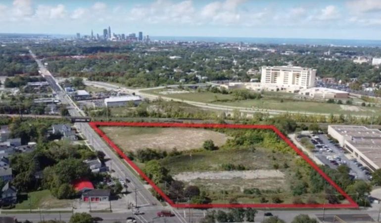
Image: A site at Woodland Avenue and Woodhill Road in Cleveland scored highest among five sites compared by a new online tool measuring factors such as racial equity in job locations. Credit: Team NEO/Fund for Our Economic Future via Cleveland.com.
City Tech: As Delivery Methods Evolve, Will City Streets Keep Up?
For years, innovations in alternative mobility—scooters, e-bikes, autonomous vehicles—have focused on how individuals get around. But the pandemic era has put fresh emphasis on a different mobility goal: moving stuff around.
The demand for rapid delivery has increased sharply in the past two years, and it doesn’t seem to be abating. By some estimates, companies like Door Dash see the quick delivery of groceries alone adding up to a $1 trillion market. With major companies from UPS to Domino’s trying out new ways to deliver their products, the pace and range of vehicle experiments has accelerated—and that is likely to impact the design, planning, and regulation of urban and suburban spaces.
While it’s unclear which of these experiments will pan out, it’s undeniable that new kinds of delivery vehicles are or soon will be on our streets. With new questions arising, urban design thinkers, retail and technology companies, and municipalities are working to address the convergence of increasing delivery demand and new vehicle forms. Leading the micro-mobility pack is the e-bike, a form that’s been around for decades but has lately become strikingly popular: with sales up 145 percent since the pandemic started, e-bikes now reportedly outsell electric cars. John MacArthur, a program manager at Portland State University’s Transportation Research and Education Center (TREC), has been researching their potential—including the “tantalizing hope” that micro-mobility tech gets more people out of cars—for the better part of a decade. Last year, he taught a new class focused on cities dealing with all manner of new micro-mobility experiments, or “technologies being thrust in the public right of way.”
Students in that class found that the pandemic was inspiring a range of responses from cities. On the one hand, work-from-home trends reduced and reconfigured car-centric commuter patterns. In Portland and elsewhere, MacArthur notes, that led to the creation of more bike and bus lanes. On the other hand, delivery demand spiked, leading to concern about a corresponding spike in single-occupancy delivery vehicles.
MacArthur’s research connected him to Portland’s B-Line Urban Delivery, a 12-year-old firm that operates a fleet of electric cargo trikes that can handle 500-pound loads. With input from TREC and B-Line, Portland is now considering ways to create “micro-delivery hubs.” In this model, a truck brings a load of deliveries to a strategic location, with e-bikes or other micro-vehicles handling the last mile for each delivery, reducing traffic congestion. Such experiments are already underway in Europe, where delivery giant UPS has been experimenting with e-bikes, delivery hubs, and other “sustainable logistics solutions.”
MacArthur acknowledges that complicated zoning and other issues are involved. But the bigger point is that Portland is among the cities proactively grappling with the future of mobility and how cities can respond to it and, more important, shape it. Shaping the response to new vehicle forms was a theme of a recent “Rebooting NYC” research project spearheaded by Rohit Aggarwala, a senior fellow at the Urban Tech Hub of the Jacobs Technion-Cornell Institute at Cornell Tech. Aggarwala—who previously led mobility work for Sidewalk Labs and recently joined New York City government as commissioner of the Department of Environmental Protection and the city’s chief climate officer—sketches the broader context. “If a vehicle is designed to fit well in traditional traffic, then it is almost by definition not designed to be a good urban vehicle,” he says. Cars, pickups, and SUVs are built for highways; their makers put far less emphasis on, say, turning radius or other factors that would make them more suited to the narrower confines of urban streets.
Thus the rise of new, smaller autonomous vehicles such as the Nuro, shaped like a diminutive van and about half the width of a conventional sedan; with no driver, it’s designed to haul up to 500 pounds of cargo. The startup might be best known for a limited pilot program in Houston with Domino’s, offering “the world’s first fully automated pizza delivery service.”
While such wee vehicles are pitched as virtuously reducing not just pollution but also traffic congestion, the reality is that they’re often fundamentally unsuited to real-world traffic. So where can they go?
Another recent pilot program involving startup Refraction AI’s REV-1 had the three-wheeled, washing machine–sized autonomous vehicle hauling pizzas via bike lanes in Austin, Texas—a development that some cyclists were not pleased about. “What if in two years we have several hundred of these on the road?” one bike advocate asked a local journalist. Yet another startup, Starship, has been testing its small mobile robot—a 55-pound object with the footprint of a wagon—in several cities, using sidewalks. This, too, has met with a mixed response. Such responses signal a major potential flashpoint, but also, perhaps, an opportunity. Aggarwala points out that in New York and other cities, bicyclists and e-bike users (who are often delivery workers) have long battled over bike lane use. In many cases, bike advocates have fought for years or decades to establish dedicated lanes, and have little interest in seeing them clogged with newfangled motorized vehicles of any kind.
But the problem isn’t the e-bikes or AVs or robots, each of which offers positive alternatives to traditional cars, Aggarwala says: “The problem is all these alternative vehicles being shoehorned into an incomplete network of generally unprotected lanes that are way too narrow.” Thus the “Rebooting NYC” proposals include creating New Mobility Lanes. This would involve widening and expanding the city’s existing bike lanes into a “network that can accommodate both bicycles and these new vehicles.”
Other researchers have made similar proposals for “light individual transport lanes,” with varying specifics but a common goal. “You’re basically providing more space for different kinds of vehicles,” says MacArthur of PSU. “That’s the big question that planners will have to face in the next five years.” It’s a knotty challenge for municipalities caught between the ambitions of tech companies, the limits on local regulation resulting from superseding state or federal rules, and the reality that even designating bike lanes in the first place depends more on mustering political will and popular support than it does on the planning that underpins it.
On that last point, Aggarwala suggests a potential opportunity. As a political matter, bike lanes are often seen as benefiting just a portion of the population at the expense of everyone else. But pretty much everyone has been stuck behind a delivery vehicle. And, maybe more to the point, more of us than ever have come to depend on those delivery vehicles. So rejiggering the way road space is divided doesn’t just benefit the few—it’s for nearly everyone. In other words, Aggarwala asks: “What if you broaden the relevance of a bike lane by expanding its use?”
Clearly a wave of new-vehicle experimentation is poised to disrupt the delivery business, in a time of unprecedented demand. It’s worth thinking about how planners and policy makers can not just respond to that wave, but harness it to help make city streets more functional and accessible for all.
Rob Walker is a journalist covering design, technology, and other subjects. He is the author of The Art of Noticing. His newsletter is at robwalker.substack.com.
Image: Nuro, an autonomous vehicle company founded by two former Google engineers, has partnered with companies including Domino’s, CVS, Walmart, and FedEx on delivery pilot projects in several U.S. states. Credit: Domino’s.
2022 Journalists Forum
Abril 1, 2022 - Abril 2, 2022
Cambridge, MA United States
Free, offered in inglês
SHARE
The Lincoln Institute’s 2022 Journalists Forum, held April 1–2 in Cambridge, Massachusetts, explored the central role of land in addressing the climate crisis, with thought leaders identifying trends, underreported stories, and fresh angles to guide journalistic storytelling at this pivotal time. The Forum investigated how land policy can contribute to an equitable net-zero transition amid competing pressures, including market-driven speculation for higher ground and land that will be newly viable in a warming world. The Forum also included two “Practicing the Craft” sessions, during which the invited journalists shared perspectives on the challenges of covering the story of the century.
In Petaluma Neighborhoods, the ‘Extravagant Life’ Is Over as Climate Activism Grows
“Bill McKibben, who most recently founded an environmental movement for people older than 60 called Third Act, said in an interview that privileged Americans, specifically those near or at retirement age, must muster their wealth and influence to push governments and corporations to divest in fossil fuels.”
—Julie Johnson, San Francisco Chronicle
The Colorado River is in Crisis, and It’s Getting Worse Every Day
“Demand in the fast-growing Southwest exceeds supply, and it is growing even as supply drops amid a climate-change-driven megadrought and rising temperatures.”
—Karin Brulliard, Matt McClain, and Erin Patrick O’Connor, with John Muyskens from the Washington Post
Welcome and Opening
Speakers
George W. “Mac” McCarthy,U.S. CEO and President, Lincoln Institute of Land Policy
Brian Golden,former Director, Boston Planning and Development Agency
Land can help address the climate crisis, but it is under tremendous pressure from market forces running far ahead of planning and regulation, while competing demands—agriculture, renewable energy, carbon sequestration—are leading to relentless conflicts.
Speakers
Patrick Welch,Climate Strategies, Lincoln Institute of Land Policy
The world will need hundreds of millions of additional acres of agricultural land to feed its people—but the same amount needs to be kept in conservation, to soak up carbon and save water. This discussion explores the shift in agricultural and water and land management practices with the Colorado River Basin as case study.
Speakers
Bruce Babbitt,former governor of Arizona, Secretary of the Interior
Jim Holway,Babbitt Center for Land and Water Policy
This super tree could help feed the world and fight climate change
Land in Conservation
Deforestation and land clearing are accelerating despite research showing natural areas do an extraordinary job sequestering carbon. Pledges by the Biden administration and governments around the world are complicated by equity issues in developing world economies, and by a gaming of the system to claim exaggerated carbon offsets.
Speakers
Jim Levitt,International Land Conservation Network
Chandni Navalkha,Sustainably Managed Land and Water Resources, Lincoln Institute
Mark Anderson,The Nature Conservancy/Lincoln Institute Kingsbury Browne Fellow, 2021–22
Anthony Flint,Lincoln Institute of Land Policy (moderator)
A brief overview of climate coverage collaboratives, and a discussion of emerging institutional structures and journalistic approaches to match the enormity of the climate story.
Speakers
Nancy Gibbs,Shorenstein Center on Media, Politics and Public Policy, Harvard Kennedy School
A discussion of the prospects for meaningful national climate policy in the United States in the context of political polarization and legislative gridlock.
Speakers
Bill McKibben,Middlebury College
Andrew Wishnia,Deputy Assistant Secretary for Climate Policy, US Department of Transportation
Public investments in both climate mitigation and adaptation increase land values—and therein lies a source of revenue to finance climate action, which is being tested in Boston and around the world.
Speakers
Enrique Silva,Vice President of Programs, Lincoln Institute of Land Policy
Erwin van der Krabben,Radboud University, The Netherlands
Lourdes German,Executive Director, The Public Finance Initiative, faculty, Harvard University Graduate School of Design
Managed retreat is increasingly part of the policy conversation. Yet climate migration is fraught with fairness and equity issues, even as some Americans move to, or remain in, areas at high risk of flooding, fire, and drought.
Speakers
Amy Cotter,Director, Climate Strategies, Lincoln Institute of Land Policy
Daryl Fairweather,Chief Economist, Redfin
Rachel Cleetus,Union of Concerned Scientists
Lanor Curole,United Houma Nation
Alexandra Tempus,freelance journalist and author (moderator)
Technological advances are enabling a global dashboard for monitoring the planet’s land use changes—whether deforestation, inundation, or drought—that can facilitate policy measures in real time, and provide data visualizations for powerful, interactive storytelling.
Speakers
Jeff Allenby,Center for Geospatial Solutions, Lincoln Institute of Land Policy
Peter Colohan,Internet of Water Initiative, Lincoln Institute of Land Policy
Even as media organizations establish climate teams, covering the climate crisis has entered a new phase of complexity. This discussion of political and cultural challenges explored the task of presenting technical material for audiences coming to a consensus for the need for action.