El curso analiza proyectos diseñados para promover el redesarrollo, regeneración o reconversión de áreas urbanas deterioradas o abandonadas, la ampliación de los perímetros urbanos, el fortalecimiento de ejes de crecimiento y/o la creación o rehabilitación de áreas de centralidad, incluyendo los centro históricos. Adicionalmente, abarca una amplia temática que incluye los instrumentos de gestión y ejecución de los grandes proyectos urbanos, las alternativas para su financiamiento, los mecanismos de redistribución justa de cargas y beneficios, y los criterios para el análisis crítico de las iniciativas.
Desenvolvimento Econômico, Economia, Infraestrutura, Regulação dos Mercados Fundiários, Uso do Solo, Planejamento de Uso do Solo, Saúde Fiscal Municipal, Planejamento, Finanças Públicas
Growing Water Smart
Workshop Helps Western Communities Integrate Water and Land Use Planning
By Katharine Wroth, Fevereiro 4, 2020
SHARE
During the last two decades, the population of Fort Collins, Colorado, expanded from 100,000 to 170,000. According to the city’s newly adopted comprehensive plan, that total is expected to swell to 240,000 by 2040. As one of the fastest-growing cities in one of the fastest-growing states in the country, Fort Collins has identified priorities for managing its future that range from increasing affordable housing to embracing clean energy with the goal of becoming a carbon-neutral community. Among its action steps: reducing water consumption in new and existing buildings as part of an effort to “ensure that water is used wisely and our community is prepared for a changing climate.”
For Fort Collins and other communities across the West, the dual pressures of rapid development and climate change are making water an increasingly precious commodity—and an increasingly hot topic. As these communities are discovering, planning for the future requires thinking differently about how and where to build, how much water to allocate to new and existing developments, and how to balance water needs with available supply. To help facilitate this shift, the Sonoran Institute and Babbitt Center for Land and Water Policy have developed a multiday workshop that helps community leaders communicate, collaborate, and take action.
Growing Water Smart: Integrated Water and Land Use Planning Workshop, which won an award from the Colorado chapter of the American Planning Association in September 2019, helps land planners and water managers explore how land use and climatic trends impact water supply and demand at the state and local level. Building on the momentum created by the adoption of Colorado’s first statewide water plan in 2015, it also introduces communities to strategies and tools that can help them integrate water and land use planning to better adapt to change and uncertainty.
“When we heard about the Growing Water Smart program, we saw it as an opportunity to build better partnerships with the planning community,” said Fort Collins Water Conservation Program Manager Liesel Hans. “We knew we needed to be thinking about water and land use planning more strategically.”
The city put together a team that included a member of the city council, the head of its planning agency, and water resources managers including Hans. “We got people in a room who don’t typically get together,” Hans said.
Nurturing that kind of collaboration is exactly the point, said Jeremy Stapleton, director of Resilient Communities and Watersheds at the Sonoran Institute. “Water is one of our biggest challenges,” said Stapleton, who leads the Growing Water Smart program. “If we don’t get the water problem solved, there will be cascading effects. And solving it is going to take relationships and collaboration at a scale greater than we’ve seen.”
Ultimately, the goal of the program is to promote the idea of being “water smart from the start,” Stapleton said. Noting that water needs are often factored in after development projects receive approval, he said it benefits developers, residents, and community leaders alike to address this critical issue far earlier in the planning process: “It makes sense to make water-smart development the easiest type to build.”
To be selected for the workshop, potential participants must submit an application that describes their water supply and demand policies and practices, community awareness and acceptance of water-related forecasts and figures, issues they hope to address, and the current level of readiness and collaboration among various departments. They assemble a team of five to seven people who work closely with assigned facilitators during the three-day training. Members might include elected officials, water managers, representatives of municipal departments such as economic development or public works, and partners from the nonprofit and consulting sectors. The teams can hail from a single community, a county, or a multijurisdictional region. Their goal: to emerge with a one-year action plan.
“Each session is a progression,” said Faith Sternlieb, who manages Growing Water Smart for the Babbitt Center for Land and Water Policy and has facilitated community teams at several workshops. “Sometimes team members don’t know each other, even when they work in the same office. They start to share resources, data, and information, and explore how they can work together to achieve the goals identified in their application. They end up with an action plan for the year, and we encourage them to make it as specific as possible: if they’re going to have a meeting, who needs to be there, who will invite them, where and when will it be held, what is the goal, who is going to present, what are they going to present? It can be a hard and painful process, but you see collaboration and decision-making unfold before your eyes.”
Torie Jarvis, a lawyer and former rafting guide who works as a consultant for the Northwest Colorado Council of Governments (NWCCOG) Water Quality and Quantity Committee, has also been a facilitator at the workshop. “The great thing about the program is that the level of sophistication for jurisdictions varies widely, yet the format still works for everyone,” Jarvis said. She said participants have ranged from large cities with progressive approaches to water management to tiny towns on the Western Slope—a region that sends more than half of the water from some of its river basins across the Rocky Mountains to Front Range communities to the east—that are grappling with how to pay for basic infrastructure. “The model works no matter where you are in the process,” she said.
Fellow NWCCOG member Will Dujardin attended a workshop as a representative of the Crested Butte Town Council, taking his place on a team that included representatives from three municipalities within Gunnison County and from the county government. “We are all facing similar challenges, and the workshop helped us get to the same baseline,” said Dujardin, who was recently appointed mayor pro tem. Now back at their respective desks, the team members continue to connect regularly, and are considering follow-up activities including a local workshop and speaker series. “The fact that we’re still making headway shows how useful the program is,” Dujardin said. “Growing Water Smart acted as a catalyst for us.”
To make follow-up projects possible, Growing Water Smart invites participating communities to apply for up to $10,000 in technical assistance funds. The Fort Collins team took advantage of this opportunity to conduct meetings and planning exercises focused on how to assign water to new types of development such as mixed-use projects and townhouses.
Tangible outcomes in other communities have included formal Intergovernmental Agreements and MOUs, collaborations between agencies, and case studies, Stapleton said; a workbook produced by the Sonoran Institute also guides communities through the nuances of integrated water and land use planning.
During the three years since it began, the Growing Water Smart program—which has flourished with additional support from the Colorado Water Conservation Board and the Gates Family Foundation—has worked with more than 34 jurisdictions that are home to an estimated 50 percent of Colorado residents, Stapleton said. The program has just expanded to Arizona, tailoring its methods and messaging for a state that is facing similar water-related challenges, but in different political and geographic contexts.
Efforts are also underway to introduce the program in California. The Sacramento-based Local Government Commission (LGC)—a nonprofit, nonpartisan organization that convenes leaders with the goal of advancing policy and creating more livable communities—is partnering with the Sonoran Institute and Babbitt Center to adapt the curriculum for communities there. LGC’s program areas include a focus on the water-land nexus, and Growing Water Smart “meets all the needs we are identifying in California” in terms of education and capacity-building, said Danielle Dolan of LGC. After attending one of the Colorado workshops, Dolan began working with LGC colleague Atley Keller to draft a California-focused curriculum that reflects the fact that the natural and political landscape of the state is, as Keller puts it, “complicated and constantly changing.”
Dolan is now working with Stapleton to secure funding for a potential California pilot that would begin building the capacity of individuals and agencies to collaborate, which she says is critical in the face of development pressure, limited natural resources, and encroaching climate change. “Everyone is working frenetically in their own little bubbles without coordinating, and they are going to make decisions that are counterproductive,” she said. Dolan believes Growing Water Smart, if widely adopted, “holds tremendous potential for shaping the future growth of the state.”
As far as Stapleton is concerned, the more bridges the program can help build among water managers, elected officials, and planners in the rapidly developing West, the better. “A lot of communities don’t have the water they need for the growth they are having or aspire to have,” he explained. “The communities that are going to thrive are the ones that are having these conversations now.”
Katharine Wroth is the editor of Land Lines.
Photographs in order of appearance
In the three years since its creation, the Growing Water Smart workshop series has guided representatives from more than 30 Colorado jurisdictions through a strategic, collaborative process focused on the intersection of water and land use planning. This month, the program expands to Arizona. Credit: Courtesy of the Sonoran Institute.
“Everything was fine until it wasn’t,” reads the first line of these notes from a recent Growing Water Smart workshop. The program encourages municipalities to plan for a swiftly changing, resource-constrained future. Credit: Courtesy of the Sonoran Institute.
With the arrival of 2020, Minneapolis becomes the first major U.S. city to implement a ban on single-family zoning in every neighborhood. For decades, single-family zoning had locked up nearly three-quarters of the city’s urban land in low-density housing and had contributed directly to lasting racial inequities. The historic and controversial policy shift—which comes with the formal adoption of the Minneapolis 2040 comprehensive plan and follows years of research, planning, and political maneuvering—will allow duplexes and triplexes citywide. It has been hailed as a significant and replicable step toward more effective and equitable use of urban land, and has inspired or helped inform similar shifts across the country.
From an economic and planning perspective, undoing single-family zoning is “a momentous idea,” says William Fischel, emeritus economics professor at Dartmouth College, a zoning board member in Hanover, New Hampshire, and author of the Lincoln Institute of Land Policy book Zoning Rules! The Economics of Land Use Regulation (Fischel 2015). “I heartily approve of what Minneapolis is doing.”
The movement toward exclusively single-family neighborhoods in the United States began in the 1910s and 1920s, says Fischel. “Advocates of zoning were unabashedly in favor of the single-family house” for many reasons, including public health; such structures were seen as improvements to crowded and unsanitary urban neighborhoods. The turning point that made single-family zoning so desirable across the nation came in the 1970s, when inflation made housing a very attractive equation for building personal wealth, he says. Beginning in the 1980s and 1990s, with the rising value of homes, people found that they could stop development in their single-family neighborhoods through zoning. “That’s been a clear goal all over the country, to protect single-family-zoned housing,” mostly from incursions of industry or denser and more affordable housing, says Fischel.
Single-family zoning is a barrier to home ownership for those who can’t afford to purchase a home, effectively locking up certain neighborhoods. During the Minneapolis 2040 process, its champions—including a progressive mayor and city council, along with the city’s Community Planning and Economic Development (CPED) department—presented the comprehensive plan as part of the solution to addressing the enduring effects of policies that intentionally and systematically discriminated against communities of color. The resulting disparities, the plan says, were “rooted in overt and institutionalized racism that has shaped the opportunities available to multiple generations of Minneapolis residents.” As the plan notes, Minneapolis has both the nation’s lowest home ownership rate among black households and the widest unemployment gap between black and white residents.
“Equity drove this in a big way,” says Caren Dewar, executive director of the Minneapolis-based Urban Land Institute (ULI) Minnesota, whose members include large multifamily and affordable housing developers, urban planners, architects, and others. “It was a bold move, and it was hard. City council members ran on a very progressive platform, supported by a group of savvy and engaged advocates who supported overcoming racist history and providing more housing.”
As Minneapolis begins its history-making policy implementation, other cities and states have begun to implement shifts that encourage density, equity, and affordability, from allowing accessory dwelling units (ADUs) in parts of Washington, DC, to passing statewide legislation in Oregon that legalizes certain types of multifamily properties in cities of 10,000 or more. Others are watching to determine how dismantling single-family zoning will not only provide more places to live, but also change the physical, economic, and social landscape of cities.
Housing Woes in a Growing City
Between 2010 and 2016, Minneapolis added more than 37,000 residents and 12,000 homes, increasing its population 11 percent to 425,000, according to estimates from the Metropolitan Council (Met Council), the policy and planning agency for the Twin Cities metropolitan region. This growth is part of a rebound from the decades of decline that had occurred since the city’s population peaked at nearly 522,000 in 1950—changes related to the loss of industry, “white flight,” and the construction of new suburbs. The Minneapolis metro region’s population is expected to grow as much as 10 percent per decade, to 3.7 million by 2040, according to the Met Council. To meet existing and future housing demand, the region needs to add more than 14,000 homes each year for the next two decades.
Now boasting one of the lowest vacancy rates in the U.S., 19 Fortune 500 companies, and steady economic and population growth, the Minneapolis-St. Paul area is ranked first in the Midwest for real estate investments, especially in rental properties (PwC 2019). But it also ranks first in a more dubious arena: Minneapolis has the nation’s lowest black home ownership rate, according to a 2018 analysis of 128 U.S. cities conducted by the APM Research Lab, a sister company of Minnesota Public Radio News. The study showed more than 70 percent of white households in these cities, but only 40 percent of black households, owned their home. In Minneapolis, the gap was more pronounced: 78 percent of white households, and only 19.8 percent of black households, were homeowners (APM 2019).
Minneapolis is also grappling with an affordable housing crisis amplified by a lack of housing options, particularly smaller residences suitable for first-time buyers and those looking to downsize. These “missing middle” properties include duplexes, triplexes, cottage courts, and small apartment buildings. Such multifamily buildings were a valued part of the city’s urban fabric until the 1940s, when single-family zoning began to take hold. Many were grandfathered into the single-family zones, which now encompass 70 percent of the city’s 54 square miles.
In the past decade, rising home prices and the lack of housing types have boosted the percentage of renters from 49 percent to a 52 percent majority. The cost of single-family homes has been rising steadily in recent years, and the median home price hit $290,000 in June 2019, a 7.2 percent increase over June 2018, according to the Minneapolis Area Realtors, while homes in the wealthier single-family neighborhoods can sell for several million dollars. Median rent was $1,695 in the first quarter of 2019, up 3.6 percent over the previous year, compared to the U.S. median monthly rent of $1,530 (Clark 2019). Financial pressure on renters has been compounded by decreasing wages: since 2000, the median income of Minneapolis renters has declined 14 percent as median rent increased 11 percent. The plan notes that the city’s economic gaps by race are significant: black households earn a median income of $20,871, less than a third of the $65,000 earned by white households, and 45 percent live below the poverty line. These disparities are at least in part the outcome of exclusionary zoning, research suggests.
Mapping Prejudice
In 2016, an interdisciplinary team of community activists, students, and scholars from the University of Minnesota began a project called Mapping Prejudice. The goal of the project was to make structural racism visible by identifying and mapping the property contracts that made many neighborhoods racially exclusive during the 20th century. Although this practice was not limited to Minneapolis (see sidebar), their effort was the first comprehensive visualization of racial covenants for an American city.
The team’s intent was to work with residents, activists, and policy makers to understand how contemporary inequities were rooted in historic injustices. Using GIS and with help from volunteers, the team has been reviewing more than 1.4 million digital scans of warranty deeds in Hennepin County from 1900 through 1960, and has uncovered more than 20,000 covenants for private homes that specifically excluded people on the basis of race or ethnicity. These findings demonstrate that structural barriers stopped many people of color from buying property and building wealth for most of the last century.
When the city’s first racially restrictive deed was written in 1910, Minneapolis was not particularly segregated, but covenants “changed the landscape of the city,” notes the Mapping Prejudice website. For example, a 1919 advertisement in the Minneapolis Tribune offered “restricted” housing sites overlooking one of the city’s lakes that could not be sold, mortgaged, or leased to anyone of African, Asian, or Jewish descent. The Mapping Prejudice research revealed that most deeds were crafted mainly to exclude blacks, who were pushed into small areas of North Minneapolis as racially restrictive deeds increased—even as the number of black households also grew.
In the 1930s, federal housing administrators endorsed these documents, requiring them for projects that used federally backed financing. Lenders followed suit, accepting the rationale that covenants provided the essential insurance of stable investments in residential property. Banks routinely “redlined” or denied loans for properties in racially mixed neighborhoods, and increasing sections of the city became entirely white, laying the groundwork for patterns of residential segregation that still exist today. Though the laws would change—the U.S. Supreme Court made covenants unenforceable in 1948, the Minnesota Legislature prohibited their use in 1953, and the U.S. Congress banned racial restrictions as part of the Fair Housing Act of 1968—the effects of covenants and predatory lending practices would endure in Minneapolis and elsewhere.
Partnering with the Mapping Prejudice team, city planners compared zoning maps and demographic data with redlined areas and found they had nearly identical boundaries. They documented that even after redlining was abolished, people of color had been excluded from most of the single-family neighborhoods in the city, and thus had been prevented from owning homes, accumulating wealth, and having access to the better jobs, transit, educational opportunities, parks and open space, and other benefits available to residents of more affluent white neighborhoods.
The areas that were covenanted are largely white and among the wealthier parts of the city today, while the areas engineered to be largely black remain that way and are among the city’s poorest neighborhoods. Where shifts are occurring—in some areas of North Minneapolis, for example—they follow patterns of gentrification, as white residents priced out of other areas “discover” mostly black neighborhoods with lower-priced housing.
The Mapping Prejudice project proved that “Minneapolis had a direct link from racially biased zoning to single-family zoning,” says Heather Worthington, CPED’s long-range planning director. When it came time to design the comprehensive plan, “the linkage between the racially biased housing and lending practices and covenants was really the important policy underlayment, as these informed the development of single-family zoning,” Worthington says. “That was the first reason we had to address the city’s single-family zones.” The second: “We heard from Minneapolis residents that, as they aged, they couldn’t access other types of housing, as so much of it was single-family, one-size-fits-all kind of housing. They wanted more choice, and places to downsize. We had a huge racial disparity and [we also had] a large segment of the population that said, ‘We want more options.’”
Residential Segregation and Exclusionary Zoning
Minneapolis was the first large city in the country to enact a fair housing ordinance, and Minnesota was one of the first states to pass a civil rights law outlawing housing discrimination, says Myron Orfield, a professor at the University of Minnesota Law School and director of the Institute on Metropolitan Opportunity (Orfield 2017). But residential segregation endures in this city and in communities across the country—the result of “a century of social engineering on the part of federal, state, and local governments that enacted policies to keep African Americans separate and subordinate,” notes Richard Rothstein in The Color of Law (Rothstein 2017).
While the federal Fair Housing Act prohibits housing discrimination based on race, color, national origin, religion, sex, ability, and familial status, it does not prohibit class-based, or economic, discrimination—a legal loophole that permits continued discrimination against communities of color, which tend to be lower-income due to historical barring from home ownership and educational opportunities (DeNinno 2019). Housing segregated by income level is increasing due to exclusionary zoning policies that municipalities or individual neighborhoods use to reduce affordable housing options through restrictions against apartments, townhomes, and other forms of multifamily housing, and such policies are still legal under current federal law, writes Richard Kahlenberg, senior fellow at the Century Foundation, in The New York Times: “Rising class segregation by residence is partly related to rising income inequality, but it is also the result of an expansion of exclusionary zoning.” In extremely wealthy neighborhoods with very large lot requirements, he notes, “policies can effectively exclude virtually all families not in the top one percent by income and wealth” (Kahlenberg 2017).
Kahlenberg argues for a new economic fair housing act to curtail government zoning policies that discriminate based on economic status. Such a law could ban exclusionary zoning at the local level or impose a penalty on municipalities that maintain discriminatory zoning, either by withholding infrastructure funds or by limiting the tax deduction homeowners can take for mortgage interest.
Laying the Groundwork for Change
In April 2017, a previous city council unanimously adopted 2040 comprehensive plan goals that addressed key areas including racial disparities, housing and transit, and climate resilience. Later that year, the election of an especially progressive city council slate brought new mandates to Minneapolis. Elected to a second term and as president of the council was Lisa Bender, a cycling advocate and urban planner with a master’s degree in city and regional planning from the University of California, Berkeley, who had introduced a successful ADU ordinance in 2014. Andrea Jenkins, the first black, transgender woman to hold public office in the country, won a seat on the council after campaigning on a platform that included raising the minimum wage and increasing affordable housing supplies. She is now vice president of the council. Jacob Frey, a civil rights attorney and community activist, was elected mayor, and also ran on a platform of expanding housing.
The zoning changes Bender, Jenkins, Frey, and others promoted through Minneapolis 2040 faced fierce opposition; “Don’t Bulldoze Our Neighborhoods” lawn signs appeared around town, mostly in whiter, wealthier neighborhoods. Many in Minneapolis say the eventual success of the plan was attributed to a concerted effort to engage in community outreach by city officials and various local Yes in My Backyard (YIMBY) activist groups.
The community engagement process underpinning Minneapolis 2040 spanned more than two years and 200 meetings, garnering over 18,000 public comments. The breadth and depth of the community outreach was unprecedented for the city, says Worthington, including community workshops and dialogues, artist-supported events, and online engagement. Planners were very intentional in seeking out communities that were typically underrepresented in planning efforts, such as renters, people of color, the disability community, and seniors, she says. “We tried to meet people where they were, have more visual presentations, and use innovative tactics. We went to many festivals and programs and jumped on buses and light rail to talk to people.” They also worked to achieve a much greater level of transparency than previous planning efforts.
Part of the process was educating residents by partnering with the Mapping Prejudice team, who presented findings and participated in discussions. “Minneapolis has a lot of what I call ‘progressive dissonance’—people who describe themselves as liberal and progressive but don’t understand the bias going back 100 years,” Worthington says.
For the first few months of the planning process, planners were often booed at meetings and received abusive emails. By the final months, she says, people wanted to learn more. It became “we’re all in this together and need to work together” to solve housing and equity issues, she says, rather than a Not in My Backyard (NIMBY) concern about preserving neighborhood character.
Duplexes and Triplexes
To be clear, the new zoning in Minneapolis does not prohibit construction of single-family homes. It simply says that no neighborhoods in the city can have only single-family homes. New duplexes and triplexes must be built within the existing building envelope, and up to two units can be added within that footprint to owner-occupied homes. Indeed, one doesn’t have to look far to find examples of how duplexes and triplexes could work in single-family neighborhoods.
“Our city originally developed along streetcar lines, so we have many neighborhoods that have a rich diversity of housing types and land uses, including duplexes, triplexes, and smaller multifamily buildings,” Bender has said (Grabar 2018). “So we were able to keep pointing back at those neighborhoods and say, ‘This is a pretty incremental change.’”
By inserting ADUs, duplexes and triplexes, and other housing types, “we’re undoing things that have been done for a long time,” said Bender in an interview for Land Matters, the Lincoln Institute podcast (Flint 2019). The comprehensive plan process raised questions such as, how do we redefine what is the status quo, what isn’t working for people today, who gets to live here, and what are people’s aspirations for this city, she says. “We’re at a crossroads in terms of people being able to live in our city and in terms of climate change, and we have to make some good moves” and meaningful investments.
Addressing concerns that more duplexes and triplexes will change neighborhood character and overtax the city’s infrastructure, supporters of the plan point to the fact that the city had an additional 100,000 residents decades ago—mostly more people in each home—and has plenty of street, transit, and other infrastructure capacity, says CPED Director David Frank.
An early draft of the comprehensive plan allowed for fourplexes on single-family lots. But organized opposition and a staff analysis, including architect-designed models, convinced planners to limit the density. To provide perspective, Worthington notes, a typical city lot is 40 feet wide by 120 feet deep, and the maximum home size is 3,000 square feet. “Three units gets us more density on the lot but is a lot more livable” than trying to fit four in the same footprint. Three-unit developments can also use residential financing, whereas a four-unit configuration triggers commercial financing and building regulations. A triplex also doesn’t require ADA accommodations and is easier to lay out, she adds. Duplexes and triplexes “will be a relatively small change in terms of impact on neighborhoods, but can be a big opportunity for people who historically have had limited access to neighborhoods that have the best transit, grocery stores, parks, and other amenities.”
Will the new zoning cause developers to demolish single-family homes en masse and redevelop adjacent lots into multifamily buildings, as opponents have warned? Worthington responds that the economics of tearing down an existing home and building a duplex or triplex are unlikely to pencil out for larger-scale developers; a homeowner with equity who can afford to build an ADU or convert part of the home to make a duplex, she says, “is probably a better prospect.”
Worthington also points to other potential players, including two land trusts in the area that buy property and help fund affordable housing development. Eddie Landenberger, vice president and senior project manager for the Twin Cities Land Bank—a local nonprofit organization that in the past decade has helped leverage land purchases for over 1,500 single-family and multifamily homes, including many that have been rehabbed in North Minneapolis—says interest in taking advantage of the new zoning regulations is on the rise.
“We don’t have clarity yet on how many duplexes and triplexes could be built in the next year or 10 years, but we do have more single-family and smaller developers now seeing duplex and triplex as an incremental step into building multifamily buildings,” says Landenberger. The land bank has been doing deals through the city’s Missing Middle program, which provides gap financing and grants as part of the city’s multipronged approach to developing more affordable housing (see sidebar).
“The zoning change provides more opportunities for a landlord to have a couple units, and we’re starting to see smaller developers jumping into these projects,” says Landenberger. “The new zoning is already helping us with our work, as we’re now seeing entitlement processes referring to these future zoning changes.”
Minneapolis Affordable Housing Efforts
In the city of Minneapolis, 50 percent of renters and 74 percent of low-income renters are cost-burdened, according to Minneapolis 2040. Since 2000, the city has produced or preserved 8,900 housing units considered affordable for residents earning 50 percent of the area median income (AMI), which is $100,000 for a family of four in 2019. But the city also lost approximately 15,000 homes that were affordable to households at this economic level; the homes generally still exist, but they are cost-prohibitive to own or rent.
The city’s 2019 budget addressed the four pillars of Minneapolis’ affordable housing agenda— production of new affordable housing, preservation of existing affordable housing, protection of renter rights, and increases in affordable home ownership opportunities—with an historic $40 million, more than three times the city’s previous record. State and federal funds bring that total to $50 million. This investment includes the Affordable Housing Trust Fund, which was increased by $14 million in 2019 to $21.6 million. The fund provides gap financing to preserve and produce affordable rental housing for households earning less than 50 percent of AMI, with a priority for units affordable to households earning less than 30 percent of AMI.
The city also allocated $500,000 for the new Missing Middle Housing Pilot Program, which aims to develop affordable residential housing projects with between three and 20 rental or ownership units on vacant land along transit corridors. Minimum criteria for rental projects include 20 percent affordable units for households at or below 50 percent of AMI, maintained for a minimum of 30 years. Program financing for ownership projects requires at least 10 percent of units to be affordable to households at or below 80 percent of AMI. The city will finance up to $95,000 for each eligible affordable unit.
In addition to the Missing Middle pilot program, multiple interrelated efforts are underway to add more diverse and affordable housing options and a more equitable distribution of housing.
Accessory Dwelling Units (ADUs): One of the city’s goals in passing an ADU ordinance in 2014 was to provide age-in-place housing options. Planners developed design and regulatory standards for units to retain the character and context of the city’s low-density residential areas. The city eased development costs by waiving the two largest fees tied to adding a dwelling unit, a sewer availability charge and a parkland dedication fee, which together save homeowners about $4,000. The city had issued 137 permits for ADUs as of January 2019.
Inclusionary Housing: City council approved an interim inclusionary housing ordinance in December 2018 and voted to increase affordability requirements and impact fees for new upzoned development. A permanent inclusionary housing policy and ordinance proposal has been under consideration for 2020, pending city council approval. The proposed policy being considered would give developers of new rental housing with more than 20 units several options for providing affordable units on-site. These options range from requiring 4 percent of units to be affordable to those earning 30 percent of AMI to requiring 20 percent of units to be affordable at 50 percent AMI. The latter option includes tax increment financing assistance from the city. Developers could also build affordable units elsewhere or pay in-lieu. Ownership projects must have at least 10 percent of units priced as affordable for households earning 80 percent of AMI.
Affordable Housing Preservation: The city’s 2019 budget includes $3.4 million to preserve and stabilize naturally occurring affordable housing (NOAH). Launched in 2018, the 4d Program—named for the state tax classification for such properties—helps apartment building owners obtain property tax reductions of up to 40 percent if they commit to keeping 20 percent or more of their units affordable. In 2018, over 750 units with affordable rents were preserved with a 10-year affordability commitment.
Minneapolis Homes: Funded at $5 million in 2019, this program offers loans for down payment assistance and has enabled the purchase of hundreds of city-owned vacant lots and houses, including many in North Minneapolis. Under the program, the city assisted with 74 homes in 2018, and 57 were purchased by a person of color or indigenous person.
Measuring Progress
According to fair housing laws, the city can’t restrict home sales to any particular groups or individuals, but the city is searching for the regulatory lever it can use to help people move into formerly single-family neighborhoods, says Worthington. “You can do things as a private citizen, like build an ADU and rent it to a person eligible for subsidized housing,” she says. “There’s a strong thread of that kind of community activism that runs through the city.”
The comprehensive plan is “part of an ecosystem of changes in policy at the city level on regulating land use, how we incentivize housing, how we invest in areas of the city that have been disinvested in over time.” She says Minneapolis is not pinning hopes just on duplexes and triplexes, which are likely to be built gradually over time and won’t provide the volume of housing needed. Upzoning along transit corridors with newly allowed four- to 10-story mixed-use buildings, another key component of the plan, is likely to spur more homes. She says the city is working with partners to identify a set of metrics to measure progress toward affordable housing, land use, and equity goals.
Still, uncertainty lingers, among opponents of the plan and supporters alike. One lakeside single-family neighborhood near a future light-rail station is applying for a never-used local conservation district designation in an effort to forestall development there. And advocates including City Council Vice President Jenkins say effective implementation will be key.
“I have some concerns around who will be able to take advantage of these opportunities,” says Jenkins, who is participating in a 10-city Policy Link initiative to develop strategies related to displacement. She says Minneapolis has helped low-income residents buy single-family homes and has built large affordable housing complexes, but she’d like to see the city expand the homeownership program and technical assistance program “to build a pipeline for home ownership, to allow black residents to become small developers, live in owner-occupied duplexes and triplexes, stabilize their communities, and build wealth for their families.
“The new Missing Middle pilot program has a lot of potential,” says Jenkins. “That missing middle is where we can have the most success for low-income communities of color, particularly for black people.” She says the city owns hundreds of vacant lots, and “we have to be smart, creative, and intentional about these opportunities. The majority who have benefitted so far have not been people of color.” She says the city needs to “lean into” more targeted outreach and support for community development groups and mortgage education and training, and ensure that the ongoing discussion around these issues includes all communities.
Testing Incremental Change
As eliminating single-family zoning becomes more common, or at least more commonly considered, are we witnessing the end of an era? Only time will tell, says zoning expert Fischel. “Minneapolis is a very progressive city,” he says, and its zoning changes could be a special case that might not see widespread adoption across the nation. A city with a majority of renter households might have an easier time building public support for eliminating single-family zoning than a majority homeowner city. Introducing Minneapolis-inspired policy changes to cities where homeowners are a distinct majority could be one test of wider applicability. Another test could be whether such a change would be overturned by a less-progressive city council in the future.
Fischel’s recommendations for urban planners and public officials in other cities parallel what Minneapolis has just done: educate the public about exclusionary zoning and emphasize the benefits of compact urban development and density. Avoid the “NIMBYs are evil and YIMBYs are good” argument, he suggests, and explain that higher density is good for social and economic diversity and for climate resilience. “Invert the ‘make no little plans’ concept to ‘make lots of little plans,’” says Fischel. “Undo single-family zoning in one city or one neighborhood at a time and see if it works. Try incrementalism.”
References
APM (APM Research Lab). 2019. “Divided Decade: How the Housing Market Has Changed Over the Past Decade.” Data visualization. February 12. https://www.apmresearchlab.org/housingcost.
Rothstein, Richard. 2017. The Color of Law: A Forgotten History of How Our Government Segregated America. New York, NY: Liveright Publishing Corp/W. W. Norton.
Kathleen McCormick, principal of Fountainhead Communications in Boulder, Colorado, writes frequently about healthy, sustainable, and resilient communities.
Photographs (in order of appearance):
In conjunction with the comprehensive planning process that resulted in a citywide ban on single-family zoning in Minneapolis, architecture students at the local Dunwoody College of Technology collaborated with city officials to study historical housing patterns and future needs. They also designed concepts for multifamily structures that could blend in with current neighborhoods, including “Cyclist-Centered Triplex” by Laura Stene. Credit: Designing for Minneapolis 2040, courtesy of Dunwoody College of Technology.
An interdisciplinary team based at the University of Minnesota is studying the connections between contemporary inequities and historic injustices. The researchers have found archival materials including this 1919 advertisement from the Minneapolis Tribune, which restricts real estate purchases based on ethnicity. Credit: Mapping Prejudice.
Climate Change
Great Lakes Communities Use Scenario Planning to Prepare for Rising Waters
By Emma Zehner, Janeiro 15, 2020
SHARE
The national dialogue about rising waters tends to focus on coastal states like Florida and New York, with inland states largely absent from the conversation. But residents in Michigan, which has one of the longest coastlines in the continental U.S., are also contending with changes that are leading local officials to reexamine their coastal management policies. As climate change amplifies Lake Michigan’s natural fluctuations and brings increased storminess, communities are beginning to plan for an uncertain future.
Historically, for every decade or so residents have endured high waters, the next has brought retreating levels—and a wave of new lakeside development. This seesawing system, which can involve differences of up to six feet in water levels over the course of a few years, is masking a more gradual pattern of coastal erosion, according to Richard Norton, a professor of urban and regional planning at the University of Michigan. The focus on extremes, he said, has sidelined action on coastal management.
In 2014, Norton and a team of researchers started working with the City of Grand Haven and the Charter Township of Grand Haven, neighboring communities on the southeast perimeter of the lake, to think beyond current conditions and discuss best coastal management practices for the long term. At the center of their approach is a method called scenario planning.
Scenario planning allows communities to plan for an unpredictable future by exploring multiple possibilities of what could happen. The framework—which the Consortium for Scenario Planning, an initiative of the Lincoln Institute of Land Policy, promotes through technical assistance, educational resources, and a network of practitioners—has shown potential in these jurisdictions, which sit in one of the most politically conservative counties in the state and whose residents have varying views about the risks of climate change.
The Role of Local Planning
Local governments have a unique opportunity to help shape the future of coastal areas. While the National Flood Insurance Program influences private development, local governments make the majority of “public decisions that shape private development in high-risk coastal zones,” Norton and his coauthors write in a new article published in the Journal of the American Planning Association (Norton et al 2019).
However, few jurisdictions are fully embracing the role—about 40 percent of master plans from 60 Michigan Great Lakes communities studied didn’t include any discussion of coastal area management issues, according to research by Norton in the mid-2000s. At the time, three quarters of the plans hadn’t adopted any meaningful coastal area management policies.
A multi-disciplinary and multi-university team of researchers led by Norton wanted to see if scenario planning, a notoriously technical process, could be simplified and adapted to the context of municipalities that lack the technology and capacity to conduct extensive analyses. Funding for the project came from the Michigan Coastal Zone Management Program of the Department of Environment, Great Lakes, and Energy and is supported through a grant under the National Coastal Zone Management Act of 1972. The project was also supported by the nonprofit planning firm Land Information Access Association, which provides technical assistance to local leaders through its Resilient Michigan program.
Coastal management concerns are often edged out by factors including other planning issues, the role of coastal properties in providing property tax revenues, emotional attachments to properties, and resistance to government regulation, Norton said.
A few years ago, the team reached out to several towns, including the City of Grand Haven and Grand Haven Charter Township, to discuss the possibility of embarking on a consultant-led scenario-planning process. At the time, both communities were in the middle of updating their master plans. Like most of the state’s 122 jurisdictions on Lake Michigan, the two communities have small populations with limited staff capacity.
An extended planning process ensued. From 2014 to 2016, local officials, planning commissions, city council and township board, and residents from the two places took part in over 20 working meetings and presentations.
Weighing Scenarios
Norton discussed the details of the project at the annual conference of the Consortium for Scenario Planning. Central to the process was the identification of three “climate futures.” Researchers created the scenarios, based on a 20- to 50-year planning horizon, by using easily available data, including historic water level data and FEMA maps, and basic GIS analysis. In the “lucky” future, water levels remain low and the community experiences one 50-year storm (as classified by FEMA). The “expected” future assumes average water levels and one 100-year storm. The “perfect storm” scenario is characterized by high water levels and a 500-year storm.
“The process helped people understand that we weren’t just looking at the worst-case scenario,” Jennifer Howland, community development manager for the City of Grand Haven, said.
As a next step, the cross-sector team drew on a variety of off-the-shelf data related to planning and development to outline three options for how the local governments could respond in each climate future. In one scenario, the governments maintained existing structures. In a second, residents were permitted to build out based on what current zoning allows. A third option incorporated a series of best management practices (BMPs), ranging from setbacks in nearshore zones to restrictions on building within wetlands. Combining the climate futures and management options, the researchers presented nine scenarios for local officials and residents to consider. They shared the fiscal, environmental, and land use impacts of each scenario.
As part of the scenario planning process, consultants and local officials developed nine futures for communities to consider. Credit: Richard Norton, as presented at the Consortium for Scenario Planning annual conference.
In the City of Grand Haven’s “lucky” future, for example, if residents continue to build out under current zoning regulations, 207 structures will be damaged. If residents adopt BMPs, this number falls to 59.
A “lucky” future in which the Township builds out under the current zoning regulations results in $11.6 million in potential damages in areas that currently house properties bringing in $194,015 in net annual revenue. In the “perfect storm” scenario, building out under current zoning regulations results in $89 million in potential damages in areas that hold properties bringing in $358,000 in annual tax revenue.
Researchers also calculated the discrepancy between the land area designated as high-risk erosion areas by the state and the land area that they calculated would be inundated in the three climate futures. The land area identified by the state was much smaller than the land area identified as high-risk areas by researchers, highlighting the important role these local governments can play in filling the gap.
“When we first presented the materials, there were looks of shock and surprise, but once people processed the information and understood that these are reasonable futures we should be thinking about, there was less opposition,” Norton said. “If we had just gone straight to announcing setbacks, that would have been hugely controversial.”
Local officials also used other strategies to help the conversations along. Howland emphasized that science-based maps and aerial images of historic shorelines made the analysis more poignant for residents. Stacey Fedewa, community development director for Grand Haven Charter Township, said focusing on the weather-related impacts of climate change was an effective way to bring the global issue to the local level.
“If we flood from a big storm, we will be without power, the roads will be flooded, the businesses will be shut down,” Fedewa said. “Trucks wouldn’t be able to enter. If we are able to bounce back faster by being resilient, businesses shut down less, employees come back to work sooner than they would have otherwise.”
The sessions were also important in demonstrating that building close to the shore and using armoring measures such as seawalls and riprap can create long-term damage to natural beaches. This “stop nature” inclination, as Norton calls it, is exacerbating erosion of adjacent beaches and contributing to the annual foot of shoreline erosion in high risk erosion areas.
In 2018, the City of Grand Haven adopted a beach overlay district. Shoreline protection measures are restricted lakeward of the line. Credit: City of Grand Haven.
In their resulting master plans, the two jurisdictions incorporated recommendations from the process to varying degrees. The body of the City of Grand Haven Master Plan includes regulatory and infrastructure policies recommended by the researchers. The city also updated its sensitive areas overlay district and added a beach overlay district based on the aerial images presented by the researchers that show the high water mark changing over time. It created strict rules for armoring lakeward of the line established by the beach overlay district: no shoreline protection measure can be installed within this area, with the exception of specific types of seasonal temporary fencing (City of Grand Haven 2016). A new homeowners guidebook helps property owners understand what they can do and provides alternatives (LIAA 2018).
In the township, the planning director and commission included conceptual overviews and policy recommendations in the body of their plan, but chose to relegate the more detailed analyses to the plan’s appendix out of concern about resistance in the politically conservative community (Grand Haven Charter Township 2016). The township also considered new proposals to prohibit seawalls—which can interrupt natural sediment transport processes, creating larger waves and more erosion that wears down the walls over time—and to increase the setback for new construction to 200 feet from the high ordinary water mark, a significant change from the current 50-foot setback. The proposals did not pass—in part because officials were focused on taking steps to protect homes from record high water levels this fall—and regulatory decisions will remain with the current authority, the Michigan Department of Environment, Great Lakes and Energy.
“Water levels will go back down again,” Norton said. “They always have. So how can we help town officials keep this on the agenda when there is not a crisis?”
Scaling the Approach
Norton believes scenario planning is a promising tool for local decision making and thinks the fact that these governments incorporated coastal management policies in their master plans is an important step. “The simplicity of the methods is helpful,” he said. “They are focused on decisions: should they adopt setbacks or not?” Norton does acknowledge that even this simplified method typically requires some in-house expertise, such as the ability to manipulate ArcGIS.
He hopes some of the lessons learned, about both scenario planning and shoreline management, can be applied in other communities, ideally with the help of outside consultants who can provide the analysis needed at a reasonable cost or without the need for outside consultants at all. And word does seem to be spreading in the region: Howland has shared the city’s work with neighboring communities along the lake and presented at a dune symposium in East Lansing. Fedewa has encouraged Spring Lake township, north of Grand Haven, to utilize the resources of the Resilient Michigan program.
Norton, who now plans to expand his work to nearby Lake Huron, said scenario planning is an ideal tool to prepare for the uncertainty inherent in an age defined by rising waters, no matter what type. “What we are doing is very applicable in ocean coastal settings too.”
This article was published in the print edition of the July 2020 issue of Land Lines with the title “Great Lakes Communities Use Scenario Planning to Prepare for Rising Waters.”
Emma Zehner is communications and publications editor at the Lincoln Institute of Land Policy.
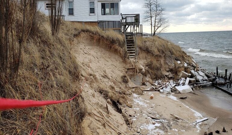
Lead Photograph: A house in Grand Haven Charter Township sits precariously close to the shore in December 2019, following several months of intense storms. Credit: Grand Haven Charter Township.
Norton, Richard K., Stephen Buckman, Guy A. Meadows, and Zachary Rable. 2019. “Using Simple, Decision-Centered, Scenario-Based Planning to Improve Local Coastal Management.” Journal of the American Planning Association. 85 (4): 405–423. https://www.tandfonline.com/doi/full/10.1080/01944363.2019.1627237.
Capital Ideas
Washington, DC's Ambitious Plan to Distribute Affordable Housing More Equitably
By Liz Farmer, Janeiro 15, 2020
SHARE
When Washington, DC, officials unveiled a major report on housing equity last fall, they did so at an unassuming, one-story bike shop located in the city’s posh Tenleytown neighborhood. This quiet district of single-family homes lies seven miles northwest of the Capitol, and the location was meant to send a message: the shop was all that was left of a plan proposed several years ago that would have added much-needed housing to the neighborhood. After fierce opposition from nearby residents, the developer scratched the mixed-use development.
Tenleytown and the other wealthy neighborhoods that make up Rock Creek West are home to the fewest affordable homes and apartments in the city—by far. Of the nearly 52,000 affordable housing units citywide, just 470 are in Rock Creek West, the city’s report found. Conversely, roughly half of the affordable housing stock (more than 25,000 units) is located in the city’s poorest neighborhoods, across the Anacostia River.
The point of the report, says Office of Planning Director Andrew Trueblood, is to lay out the current landscape for housing so that future construction doesn’t simply continue to concentrate affordable housing in lower-income neighborhoods.
“There is a reason we are where we are” when it comes to the location of affordable housing, he says. “Some of that has been through reactions to opposition, some of it has been through policy. The reasons why we’re here today haven’t gone away. But what we’re trying to do is change the discussion.”
The report sets a goal of adding 12,000 affordable homes and apartments citywide by 2025, with the largest share—nearly 2,000 units—going in Rock Creek West. Capitol Hill, another high-cost neighborhood, is targeted for 1,400 affordable units. The city plans to meet its goal by enabling new construction, preserving affordable housing set to soon expire, and converting market-rate homes and apartments into permanently affordable housing.
Mayor Muriel Bowser has set an overall housing goal of 36,000 new units within the city by 2025. Those numbers are based on an analysis by the Metropolitan Washington Council of Governments, which found the metro area (which includes suburban areas of Maryland and Virginia) needs 320,000 housing units by 2030 to keep up with population demands. As if that weren’t ambitious enough, the council called for 75 percent of the units to be affordable to middle- and low-income families.
Like many hot-market cities, Washington is struggling with a housing affordability crisis. The region is expected to gain about 413,000 new jobs between 2020 and 2030—but only 245,000 new housing units over the same period. A recent study found that 220,000 families across the region could be forced to leave their homes in the coming years as housing costs rise. At play are zoning density restrictions, gentrification, and transit connectivity needs that combine to either concentrate poverty in smaller areas or simply price low- and middle-income families out altogether.
As cities like Washington, DC, seek to create affordable housing, they are increasingly mindful that where they build matters as much as the number of new homes. For decades, government affordable housing programs focused on creating as many affordable homes as possible. That often meant selecting lower-income neighborhoods, which tended to have fewer regulatory barriers to development and less organized opposition from residents.
“One of the biggest mistakes the field made was when they went to build affordable housing, they did it in cheap areas,” says Lincoln Institute of Land Policy Senior Policy Analyst Jessie Grogan. “It ended up further concentrating poverty.”
In an effort to reverse that process, the Obama administration created a new rule in 2015 requiring cities that receive federal housing funds to take active steps to reverse longstanding patterns of segregation. The rule, called Affirmatively Furthering Fair Housing (AFFH), built on 1960s civil rights legislation that bars overt discrimination in the housing industry (which is still a problem today). The new rule is now in limbo, and a dozen states and cities—including Washington, DC—are fighting to reinstate it. But DC’s plan to combat segregation shows that governments can still embrace the rule’s principles even in the absence of federal backing.
The District’s method of setting specific housing goals by neighborhood is one such approach. Philadelphia is studying an eviction crisis that has plagued lower-income neighborhoods; during 2017, one in 14 renters faced eviction. Kansas City wants to distribute Section 8 vouchers more evenly, with the goal of breaking up concentrations of poverty in the region.
But studies and reports are ultimately the first step in what will be a difficult process. It’s one thing to say that housing in a city is unfair, as 60 percent of residents in Washington, DC’s most affluent ward did in a citywide survey last year. But it’s another thing to support a project in the neighborhood. In 2016, for example, Los Angeles voters overwhelmingly approved a tax increase to provide $1.2 billion for 10,000 units of new housing for the homeless. But development stalled for years because of a requirement that developers receive a letter of support from the local city council member. Now the project is running behind and is more expensive than expected.
DC’s goals are soft targets. Trueblood says they are designed to get the city on a “trajectory” of more equitable affordable housing distribution by 2050, as outlined in the Council of Governments report.
“It’s a lot to overcome, but the city seems to have come to a point of ‘enough is enough,’” says Alex Baca, housing program organizer for the economic development nonprofit Greater Greater Washington. But adding affordability to a part of the city where home prices regularly top $1 million is an expensive proposition. It all comes down to whether the administration is able to find political backing for the cost.
“I’m heartened to see the Bowser administration taking this seriously,” Baca adds. “But actually doing it is going to mean reducing funding for other things, and that’s where the mayor is going to have to use her power.”
Looking ahead, Trueblood says the funding and cost estimates for the program are still being worked out, but the city expects to include it in next year’s budget. The administration also plans to use planning and zoning incentives to encourage the development of affordably priced units in the city’s most expensive neighborhoods. One of those tools, an expansion of the city’s inclusionary zoning policy, will increase the density allowed in a development if the developer builds more affordable units.
Currently, the district requires 8 to 10 percent of the residential floor area be set aside for affordable rental or for-sale units, but the new policy is expected to include additional incentives for developers willing to go up to 20 percent, says Trueblood.
To him, the case for housing equity can be summed up in one stark statistic via the city’s most recent health equity report: the difference in life expectancy between the city’s richest and poorest residents is 15 years.
“It might mean hard conversations with residents who want their neighborhoods protected,” he says. “But we’ve seen how our housing policy and resident outcomes have worked so far—and we need to think in a structurally different way.”
Liz Farmer is a fiscal policy expert and journalist whose areas of expertise include budgets, fiscal distress, and tax policy. She is currently a research fellow at the Rockefeller Institute’s Future of Labor Research Center.
Photograph: Rendering of a proposed mixed-use development in Rock Creek West, a wealthy area of Washington, DC. Credit: Valor Development.

 Fellow NWCCOG member Will Dujardin attended a workshop as a representative of the Crested Butte Town Council, taking his place on a team that included representatives from three municipalities within Gunnison County and from the county government. “We are all facing similar challenges, and the workshop helped us get to the same baseline,” said Dujardin, who was recently appointed mayor pro tem. Now back at their respective desks, the team members continue to connect regularly, and are considering follow-up activities including a local workshop and speaker series. “The fact that we’re still making headway shows how useful the program is,” Dujardin said. “Growing Water Smart acted as a catalyst for us.”