Tackling Climate Change: The Not-So-Hidden Role of Land (A 75th Anniversary Lincoln Institute Dialogue)
Junho 23, 2021 | 12:00 p.m. - 1:00 p.m.
Free, offered in inglês
Speakers: Sivan Kartha, Michelle Manion, and Amy Cotter
SHARE
Watch the Recording
Watch the Recording
Land and water policy have the potential to shape the built and natural environment to reduce energy demand, remove greenhouse gases from the atmosphere, and help communities and natural systems thrive as the climate changes. Daily decisions about the use, taxation, and stewardship of land are opportunities to advance both climate mitigation and resilience in ways that enhance quality of life and place. Dr. Sivan Kartha of the Stockholm Environment Institute and Michelle Manion of Mass Audubon join Amy Cotter of the Lincoln Institute of Land Policy to discuss how land policy, from local to global scales, is essential to meeting climate goals.
Speakers
Dr. Sivan Kartha is a senior scientist at the Stockholm Environment Institute whose research and publications for the past 25 years have dealt with policy strategies for addressing climate change, focusing on equity and effectiveness in the design of an international climate regime. Dr. Kartha has also worked on mitigation scenarios, market mechanisms for climate actions, and the environmental and socioeconomic impacts of biomass energy.
Michelle Manion is vice president of policy and advocacy for Mass Audubon. Trained as an economist and in public policy and natural resources, she has over 20 years of experience advocating at the state, federal, and international level for effective, workable solutions to mitigate climate change, protect biodiversity, and create sustainable natural systems.
Amy Cotter is director of climate strategies for the Lincoln Institute of Land Policy. An urban planner by background, she has more than 25 years of experience developing and implementing land policy to promote equity and sustainability. She oversees the Lincoln Institute’s research, education and practice related to climate change, planning practice, and scenario planning.
Details
Date
Junho 23, 2021
Time
12:00 p.m. - 1:00 p.m.
Language
inglês
Registration Fee
Free
Cost
Free
Not So Fast
Lessons from Washington, DC's Experiment with Slow Streets
By Liz Farmer, Junho 3, 2021
SHARE
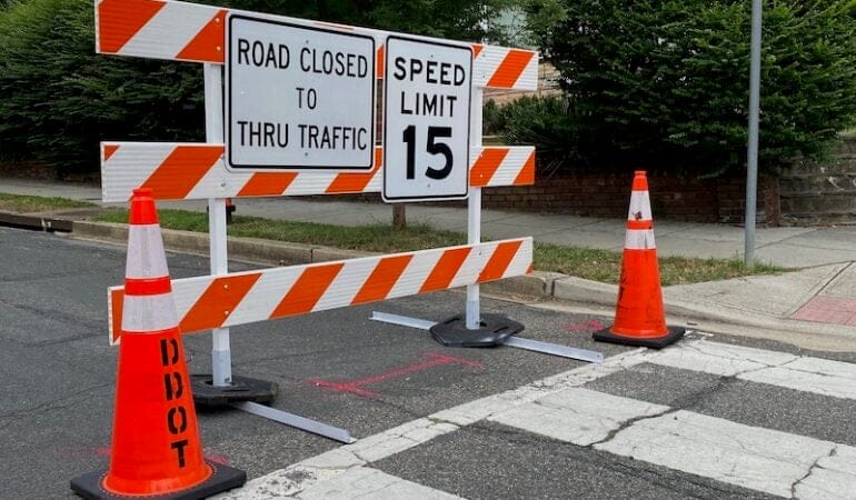
One day last spring, during the early weeks of the pandemic, a tree fell across a residential street in the Capitol Hill neighborhood of Washington, DC. With the fallen tree making it impossible for cars to pass, the streetscape quickly changed.
“Kids were out on their bikes and their scooters, neighbors were out talking to each other from across the street,” resident and Ward 6 Councilmember Charles Allen told a local media outlet this spring. “And that moment stuck out for me because it really was a [time] when everyone desperately needed more safe outdoor space.”
With many urban commuters suddenly working from home last year, the dramatically reduced car traffic in cities provided an opportunity to provide safe outdoor spaces for the public and formalize the type of spontaneous scene Allen describes. Washington was one of dozens of cities worldwide that piloted “slow streets” programs, restricting portions of mainly residential streets to local and emergency traffic and lowering speed limits. In some places, streets were closed to traffic entirely.
The programs were designed to support neighborhood-based safe social distancing for walkers, runners, cyclists, and other residents who just needed a breath of fresh air. While the concept of slow streets was generally well received, its implementation in Washington and other cities was sometimes rocky—and sparked much-needed discussions about equity, access, and planning.
Washington, DC’s program totaled 26 miles, which is comparable to those piloted in other major cities. As the city’s pilot effort wrapped up this spring, planners there—who are in the midst of updating moveDC, the city’s long-range transportation plan—were gathering public input on the experiment and considering how this experiment could inform decisions going forward. The lessons surfacing in DC, which cover issues ranging from transportation inequities to signage logistics, could also be valuable to other cities that are initiating or expanding slow streets projects this year, from Nashville, Tennessee, to Omaha, Nebraska.
“The pandemic has been hard on all of us, but there have been some benefits,” DC Council Transportation Committee Chair Mary Cheh said at a virtual hearing held in March to gather feedback on the slow streets pilot. “We’ve seen a different future or the possibility of a different future. So we should jump on that.”
The comments that came at the hearing in DC echoed those of residents in places like Oakland, Minneapolis, and Baltimore that also piloted slow streets: While they supported the concept, they were disappointed by the execution. Concerns included a lack of connectivity—among the slow streets themselves and between the streets and other destinations—as well as logistical aspects like traffic enforcement and signage.
Connectivity counts. Residents and mobility advocates in DC said not all the city’s designated slow streets were well connected, either to each other or to important points in neighborhoods. This seemed to be particularly true in lower-income areas and communities of color. For example, one slow street in the Southeast section of the city, Fairlawn Avenue, parallels a freeway. On the other side of the freeway is the Anacostia River Park, but the slow street did not connect to it. Instead, it ended at a busy intersection with no separate bike lanes, requiring pedestrians and cyclists to travel through a noisy underpass and cross freeway onramps and offramps to get to the Anacostia River Trail footpath. “It is not a welcoming trip into the park,” said transportation equity advocate and writer Ron Thompson. By contrast, four connected slow streets across wealthier neighborhoods in the Northwest section of the city created a 2.5-mile path between scenic Rock Creek Park and a retail hub on Massachusetts Avenue.
Enforcement is necessary. Although DC’s Department of Transportation stated from the outset that its slow streets were meant to be “self-enforcing,” that was an aspect of the experiment that just didn’t work, residents said. Residents reported that the lightweight construction barriers used to mark the entrance to slow streets in DC simply made them look like temporary work zones and that the streets didn’t have enough signage explaining the program. As a result, cars still regularly zoomed through and people didn’t always feel safe using the streets. This has been a problem in other cities, as well; Baltimore resident Abigail Burman told the Greater Greater Washington transportation blog in December that she regularly dragged slow streets barricades off the sidewalk. “I’ve literally never seen a barrier in the actual street,” she said.
Community buy-in is critical. Slow streets in DC also ran into deep-seated mistrust related to longstanding inequities in urban transportation. DC’s poorest district, Ward 8, whose population is majority Black and heavily dependent on public transportation, did not have any slow streets. The city had planned to introduce them, but Ward 8 councilmember Trayon White added an amendment to the citywide slow streets law barring modifications there. “Many residents in Ward 8 have not supported bike lanes and other measures that appear to force aspects of gentrification and displacement,” White wrote in his amendment. Thompson, a Ward 8 resident, said at the March hearing that the opposition around things like protected bike lanes “is part of a greater conversation about how the government has failed to deliver services to communities like Ward 8. These infrastructure improvements are seen as a sign of neighborhood change and displacement, and we have to work together to correct decades and decades and decades of that being true.”
This kind of feedback will help the city map out its next steps, according to Everett Lott, interim director of the city’s Department of Transportation. Putting out a call for public input via social media in March, Lott wrote, “We are reviewing the lessons learned from this experiment as we seek a permanent and more effective strategy to safely create spaces for people.”
Jessie Grogan, associate director of Reduced Poverty and Spatial Inequality at the Lincoln Institute, echoed the sentiment that slow streets programs are “a good idea, but we have a lot to learn about how to execute it.” The programs, she added, are a positive sign that cities are stepping back from prioritizing cars. “In the last five to ten years, bike and pedestrian advocates have gotten really good at getting cities to think more dynamically about how streets can be used,” she said.
But a big lesson learned, she added, is that cities need to be more intentional about the purpose of the streets in the first place—then design accordingly. “If you want to get people from point A to B without getting in cars, then how do you do that safely for people walking or biking?” she said. “The way it was implemented [in DC], it wasn’t in service of that goal.”
Despite the drawbacks, slow streets remain a popular idea with mobility advocates, and the lessons of 2020 will inform pilot programs and more permanent planning decisions going forward. In Omaha, Nebraska, Sarah Jones, cofounder of the local transportation equity nonprofit Mode Shift Omaha, is working on funding for a pilot program and said she plans to incorporate the lessons other cities have learned. She’s looking at planters for street barricades and more colorful signage to raise awareness. She also plans to seek community feedback before, during, and after the experiment. And in her car-loving city, she’s thinking about how to frame the program so that everyone sees how they benefit.
“Omaha is kind of anti-bike, so we really have to communicate that it’s not just about bikes—it’s for people jogging, strollers, scooters,” said Jones. “It’s about how being outside is better for mental health . . . and how we can connect places and nodes like neighborhood parks to a central retail district. If you can do that, I think that’s crucial.”
Liz Farmer is a fiscal policy expert and journalist whose areas of expertise include budgets, fiscal distress, and tax policy. She is currently a research fellow at the Rockefeller Institute’s Future of Labor Research Center.
Photograph: Public feedback in Washington, DC, has identified potential improvements to the city’s slow streets program, ranging from more equitable implementation to more effective signage. Credit: District Department of Transportation.
Rebuilding with Equity: The Future of Smaller Legacy Cities
Junho 29, 2021 | 1:00 p.m. - 2:00 p.m.
Free, offered in inglês
SHARE
Watch the Recording
Leaders in America’s smaller legacy cities—former industrial and manufacturing hubs like Dayton, Ohio, and Gary, Indiana—can adopt equitable development strategies to meet the need for sound, long-term economic growth; to respond proactively to calls for racial equity; and to remedy the inequities laid bare by the COVID-19 pandemic and Black Lives Matter movement. Improving equity broadens everyone’s access to opportunity while boosting economic prospects for an entire city.
This webinar will focus on why equitable development is a sound strategy for smaller legacy cities today. Practitioners will share stories from legacy cities that are already embracing equity and inclusion. Presenters will articulate why equity is an important goal for their city or organization, and what equitable development looks like in the smaller legacy city context.
Dorian A. Hunter is a passionate advocate for the underserved and underrepresented. Growing up on the south side of Springfield, Ohio, he saw firsthand how disinvestment and a lack of resources can affect a community. The impacts of those experiences led to Dorian dedicating his skills and talents towards building up his community. He is a cofounder of multiple organizations including DreamVision (2017), Springfield’s NAACP Youth Committee (2018), and The Unified Collective (2020). Dorian holds a B.A. in marketing and communications and M.A. in data analytics, both from Wittenberg University. Dorian was recognized as a Key Player by Cedarville University in 2018 and also received the Perseverance award from Concerned Black Students during his time at Wittenberg University. He recently started as vice president of business development & marketing and producer for Elliott Insurance Agency in Springfield, Ohio.
Lark T. Mallory practices law in the areas of taxation, corporate transactions and real estate transactions. Currently, Lark serves as general counsel and director of CDFI Investments for The Affordable Housing Trust for Columbus and Franklin County, an organization that provides low interest rate loans to developers of affordable housing. Lark’s key responsibilities include negotiating and drafting all legal agreements for the organization, coordinating transactions with outside partners, addressing all legal needs for the organization, and providing legal support to the organization’s Board of Directors. Prior to joining The Affordable Housing Trust, she was a partner with a 500-lawyer law firm with an eight-state footprint. Currently, Lark serves on the boards of the Columbus Zoo and Aquarium and River South, the organization that issues bonds to supports the development efforts in the River South area of downtown Columbus, Ohio. Lark is a CPA (inactive) and holds a B.S.B.A. in accounting and a law degree from The Ohio State University and an LL.M. in taxation from the University of Florida College of Law.
Robert M. Simpson is president of the CenterState Corporation for Economic Opportunity (CenterState CEO), an independent and forwardthinking economic development strategist, business leadership organization and chamber of commerce dedicated to the success of its members and the prosperity of the Syracuse, New York, region. He previously served as the cochair of the Central New York Regional Economic Development Council, from 2011 to 2018 by appointment from the governor. He holds board and advisory seats with the CNY Biotech Accelerator and the Downtown Committee of Syracuse. Robert also serves on numerous community boards, including the Central New York Technology Development Organization, the Upstate Minority Economic Alliance, the Syracuse Regional Airport Authority, the Lifetime Healthcare Companies, and others. Accolades include 40 UNDER 40 recognition by CNY BizEvents (2006); Onondaga Citizens League Citizen of the Year (2010); the Loretto Health System’s Legacy Award (2019); among others. Robert previously worked for Defenders of Wildlife, the State Environmental Resource Center in Madison, Wisconsin, and for the Office of John D. Rockefeller IV, in the United States Senate. Robert graduated from Colgate University in 1997, and earned an M.P.A. from the Maxwell School of Citizenship and Public Affairs at Syracuse University.
Former industrial and manufacturing hubs like Dayton, Ohio, and Gary, Indiana—known as legacy cities—need not choose between economic growth and equity, as growth is most durable when it benefits everyone, according to a new Policy Focus Report and accompanying Policy Brief published by the Lincoln Institute of Land Policy in partnership with the Greater Ohio Policy Center. Legacy cities can promote long-term growth while addressing racial and economic inequities laid bare by COVID-19 using strategies mapped out in Equitably Developing Smaller Legacy Cities: Investing in Residents from South Bend to Worcester. Using case studies of successful initiatives, the report guides practitioners through equitable investment in both physical projects and people.
Legacy cities experienced declining manufacturing economies and population loss in the 20th century, and they are now at various points on a path to revitalization. The report focuses on small to mid-size legacy cities with populations of 30,000 to 200,000 residents. Though they share many characteristics with their larger counterparts, these cities face unique challenges and require tailored approaches to revitalization.
Promising policies and strategies have emerged—as outlined in the 2017 Policy Focus Report Revitalizing America’s Smaller Legacy Cities and in the digital library of the Lincoln Institute’s Legacy Cities Initiative—and some legacy cities have seen populations grow or stabilize. As the new report shows, durable revitalization requires explicit efforts to address stark social and economic inequities.
“Leaders in America’s smaller legacy cities are uniquely positioned to test, refine, and innovate equitable development practices,” authors Erica Spaid Patras, Alison Goebel, and Lindsey Elam of the Greater Ohio Policy Center write in the report. “A robust commitment to equity is a powerful tool that can lead to a brighter future for these communities.”
Drawing on years of experience conducting research, advocacy, and outreach on behalf of Ohio’s 20 legacy cities, the authors begin the report with an explanation of how greater equity can both improve everyone’s access to opportunity and support the economic prospects of cities. For example, by providing better job training for longtime residents, a city can increase disposable income and encourage businesses to hire locally and ultimately stay in the city. Reducing entrenched poverty and increasing citizen engagement can improve a community’s long-term financial health.
The authors outline seven strategies, illustrated with a diverse set of case studies, that can lay the groundwork for a city’s equitable development agenda. Strategies are tailored to the unique challenges of these small to mid-size legacy cities and also draw on their unique opportunities—such as a lack of market pressures that allows leaders more time to get plans right.
“The strategies outlined in Equitably Developing America’s Smaller Legacy Cities will be vital in rebuilding more racially and economically equitable legacy cities,” Akilah Watkins, president and CEO of the Center for Community Progress, said. “Every municipal leader in the country should engage with this guide and be bold in their efforts to revitalize their communities in a post-COVID era.”
The recommendations can be implemented at any time, regardless of a city’s market strength, and include strategies suitable for implementation at the local level by government officials; leaders of nonprofits, foundations, or community development organizations; community outreach staff at hospital systems, universities, or financial institutions; and other practitioners. Some strategies build on existing programs—e.g., integrating racial equity analyses into routine local government decision-making—while others stand alone—e.g., programs that build the leadership pipeline and civic capacity of underrepresented groups.
“This report demonstrates a keen understanding of legacy cities, and the policy recommendations are robust and easily understandable,” said Jason Segedy, Director of Planning and Urban Development for the city of Akron, Ohio.
“The strategies address today’s pandemic climate as well as long-standing economic decline,” the authors write. “Most of these strategies are cost-effective and prioritize investing time and human capital to build collaborations rather than just spending on new construction projects.”
Strategies fall into two categories: 1) those that seek to strengthen relationships and build trust and 2) those that reduce disparities in life outcomes for residents and improve economic prospects citywide.
Strategies to Build an Equitable Development Ecosystem
Build Trust and Repair Strained Relationships: In 2016, planners in Lancaster, Pennsylvania, delivered an apology for past racist policies, including redlining and urban renewal, and their present impacts, which helped lay the groundwork for more equitable programming and community partnerships.
Build a Layered and Diverse Coalition: A diverse group of transit advocates in Indianapolis undertook a major outreach campaign, which included inclusive coalition-building and effective use of data, to demonstrate the benefits of public transit investment to businesses and community groups, ultimately winning voter approval for a tax to improve the city’s transit system.
Conduct Strategic Planning and Visioning: Erie, Pennsylvania’s Downtown Development Corporation is a non-profit intermediary responsible for coordinating the funding and implementation of downtown revitalization plans and helping to build Erie’s revitalization capacity.
Strategies That Reduce Disparities and Increase Civic Capacity
Utilize Place-Based Investments:The historic renovation of Dayton, Ohio’s downtown Arcade improved the physical quality of downtown and in the process became the shared home for several small business and innovation entities, allowing for better coordination among the groups to eliminate service redundancies and diagnose community needs.
Cultivate Homegrown Talent: A coalition of business, government, and nonprofits in Fitchburg, Massachusetts, fosters community-based leadership that reflects the diversity of the city through programs that increase the number of residents serving on local boards and engage youth in leadership development. A parent-led coalition focused on ending the school-to-prison pipeline in Gwinnett, Georgia, provides advocacy training and leadership development for parents while also promoting local, state, and national policy changes.
Anticipate Neighborhood Change and Plan for Stability: In Atlanta, Georgia, a nonprofit organized a philanthropy-funded anti-displacement program to pay for homeowners’ property tax increases in designated areas. During Ohio’s declared COVID-19 state of emergency, the village of Yellow Springs pioneered a novel eviction protection policy, requiring landlords to accept late rent payments so residents could remain in their homes.
Recalibrate Existing Operations to Better Yield Equity: The city of Springfield, Ohio, adopted compassionate code enforcement strategies to help low- and moderate-income homeowners fix code violations and avoid penalties and the Affordable Housing Trust for Columbus and Franklin County, Ohio, made concrete changes to their internal operations in order to improve measures of equity in the community they serve.
Cómo los dirigentes de Cleveland reconcibieron y reconstruyeron la ciudad tras décadas de decadencia
Por Anna Clark, Janeiro 12, 2021
SHARE
Cleveland apuntó al cielo. Llevó años de sudor y de excavar más tierra que para el canal de Panamá, pero cuando Terminal Tower celebró la fiesta de inauguración, en 1930, al instante se convirtió en ícono de la elegancia de Beaux Arts en una ciudad próspera. Según los planes iniciales del proyecto, sería un edificio de 14 pisos sobre una estación de tren interurbano, pero los desarrolladores descartaron esa visión y prefirieron un concepto más ambicioso: 52 pisos de arenisca y acero en el corazón de Public Square. Esto hizo de Terminal Tower el segundo edificio más alto del mundo.
Como nodo, Terminal Tower conectaba a Cleveland con ese mundo: todos los trenes que entraban o salían de la ciudad pasaban por la estación. Y mucha gente hacía lo mismo. El interior era un ajetreado palacio de vestíbulos, tiendas y escaleras con pasamanos de latón. El día de la inauguración, los reflectores hicieron brillar la fachada, y así comenzó una tradición de iluminación ingeniosa que aun hoy se usa con frecuencia.
Casi un siglo más tarde, es fácil ver por qué los residentes destacan el perfil urbano de la ciudad. Cleveland está ubicada sobre el lago Erie, cerca de Canadá y del canal Erie, y tiene acceso a una red de vías de tren y autopistas que la conectan con Pittsburgh, Akron, Detroit y otras ciudades prósperas; todo esto la convertía en una ubicación ideal para logística de traslados y fábricas. En la época en que se construyó Terminal Tower, la economía local consistía en automóviles, acero, equipos eléctricos y maquinaria, además de bienes de consumo: cafeteras, tarjetas de felicitación, pintura y mucho más. Allí se inventó el alumbrado público, y la ciudad adquirió fama internacional por el innovador hospital de investigación Cleveland Clinic, fundado en 1921, y la Orquesta de Cleveland, que grababa música con Columbia Records. Allí prosperaban prestigiosos museos de arte e historia natural, clubes de jazz, varietés y, también, el Play House, primer teatro regional profesional de los Estados Unidos, y Karamu House, la compañía teatral negra más antigua del país, que estrenaba las obras de Langston Hughes, oriundo de la ciudad.
En la primera mitad del s. XX, la ciudad atrajo a cientos de miles de personas, entre ellas una ola de inmigrantes de Europa meridional y oriental, durante las primeras décadas, y miles de migrantes negros del sur, en los 20 y los 30. Para promover el crecimiento continuo, en 1944 la empresa eléctrica local acuñó un lema: “La mejor ubicación de la nación”. La población siguió creciendo hasta llegar al apogeo de 914.000 residentes en 1950, lo que convirtió a Cleveland en la séptima ciudad más grande del país.
El latiguillo de “mejor ubicación” perduró durante décadas, pero la gente no. A medida que el siglo avanzaba, el éxito deslumbrante de los primeros 50 años devino en pérdidas abrumadoras: de población, industria, empleos y prestigio. Poco después, Cleveland tuvo otro apodo, mucho menos halagador. Los años de desinversión crónica sumados al aumento de la contaminación y la inseguridad dieron origen al desdichado alias “estragos en el lago”.
Con los años, Cleveland se convirtió en “el blanco de muchos chistes espantosos”, dijo Anthony Coyne, abogado nativo de la ciudad, exdirector de la comisión de planificación y miembro de la junta del Instituto Lincoln. “Los presentadores de programas nocturnos nos dieron con todo”. Pero Coyne dice que esos golpes ocultan algo que está muy vivo en Cleveland: “Nos estamos esforzando mucho por dedicarnos a mejorar la calidad de vida”, dijo, y destacó la diversidad de empleadores en atención médica, banca, educación superior y producción, además de la recuperación de espacios públicos para residentes y visitantes, como Public Square. “Es emocionante ver [estos espacios] renovados luego de tantos años de estar adormecidos”.
El liderazgo firme y el urbanismo táctico están transformando la relación entre la ciudad y los residentes. Si bien queda mucho por hacer, las grandes inversiones en una ambiciosa recuperación de la ribera, viviendas asequibles y transporte multimodal están preparando a la ciudad para una nueva era.
Aprovechar la ribera
El río Cuyahoga es conocido por el incendio de 1969, pero en esa época era muy común que las vías fluviales se prendieran fuego. En los Estados Unidos, no había regulaciones hídricas ejecutables, y era frecuente que trataran a los ríos como cloacas a cielo abierto. En este caso, lo que causó el incendio fue una chispa de un tren que pasaba por ahí, al caer sobre una mancha de aceite que flotaba en el agua. La revista Time publicó una historia sobre el incendio junto con una foto impactante, pero esa imagen era de un incendio anterior. El Cuyahoga se había quemado 13 veces.
Este incendio provocó un movimiento por el cambio en todo el país. Al día siguiente, Carl Stokes, el alcalde de Cleveland (quien dos años antes había hecho historia por ser el primer alcalde negro electo para una ciudad importante del país, y luego convenció al electorado de aprobar un bono por US$ 100 millones para mejorar las cloacas), hizo una “gira de contaminación” con un grupo de reporteros. Stokes habló con la prensa sobre los efectos de la contaminación para los residentes, y dijo que las ciudades tenían pocas herramientas para abordar el problema, en particular si las vías fluviales pasaban por varias jurisdicciones. Además, declaró ante el Congreso sobre la necesidad de una regulación federal: “Los problemas de contaminación de aire y agua de estas ciudades son tan peligrosos para la salud y la seguridad de nuestros ciudadanos como cualquier misil balístico intercontinental ubicado a no menos de 8.000 km del país”.
El incendio y las condiciones que lo provocaron inspiraron una forma radicalmente distinta de abordar las vías fluviales urbanas, lo cual hizo que en 1970 se creara la Agencia de Protección Ambiental y, dos años más tarde, se aprobara la Ley de Agua Limpia. En Ohio, los dirigentes locales también desarrollaron el Distrito Cloacal Regional del Noreste de Ohio (NEORSD, por su sigla en inglés), un sistema de gestión multijurisdiccional que ayudó a gestionar los desechos industriales y mejoró el tratamiento de aguas residuales.
Cleveland carga con un gran peso: históricamente se la asoció con la contaminación, no solo en el Cuyahoga, sino también en el lago Erie. Al ser el menos profundo de los cinco Grandes Lagos, suele ser el primero en manifestar los riesgos de la escorrentía por agricultura, cloacas y fábricas, como la profusión de algas tóxicas. Hay partes del lago que se declararon “muertas”. En un momento, a fines de los 60, la ciudad colocó cortinas con pesas en el lago, en un intento por crear sectores de agua apta para nadar. Dr. Seuss hizo una crítica a la situación en la edición original de El lorax, de 1971: habló de un pez que tarareaba “en busca de un poco de agua que no esté tan manchada. Oí que las cosas en el lago Erie también están arruinadas”.
Al igual que el icónico río de Cleveland, el lago Erie se vio beneficiado por cambios en políticas nacionales y locales, como la Ley de Agua Limpia y el Acuerdo de Calidad del Agua de los Grandes Lagos, concertado entre los Estados Unidos y Canadá en 1972. Hacia 1985, la calidad del agua había mejorado tanto que dos estudiantes de posgrado le pidieron a Dr. Seuss que corrigiera El lorax. El autor estuvo de acuerdo y respondió: “Ya no debería decir cosas malas sobre una masa de agua que, gracias a la gran labor cívica y científica, hoy alberga peces felices y sonrientes” (Egan 2017).
Tras años de abandono, se limpiaron parques y playas sobre la ribera del lago Erie; hoy, los residentes de Cleveland los eligen para sus momentos de esparcimiento. Crédito: Pgiam/iStock.
Hace unos 20 años, Kathryn Lincoln, directora de la junta y directora ejecutiva de inversiones del Instituto Lincoln, trabajó con la Fundación Cleveland para hacer una película sobre la ciudad para la serie de documentales Making Sense of Place del Instituto Lincoln, que se actualizó hace poco (LILP 2020). Lincoln, que vivió en Cleveland durante ocho años cuando era niña y hoy está en la junta de Lincoln Electric, con base en la ciudad (ver nota de recuadro en la página 35), dijo que los entrevistadores preguntaron a interesados de la comunidad qué era lo más preciado de Cleveland. “Desde donde estábamos se veía el lago”, evocó. La gente mencionaba la orquesta, los vecindarios de la ciudad o la diversidad étnica, pero “ni una sola persona mencionó el lago Erie”.
Ella atribuye esta omisión al hecho de que la ribera se ha separado del centro con vías de tren, autopistas y otros obstáculos, como barreras de concreto, rocas y acero, para resguardar de las tormentas. “Es imposible salir de la torre de oficinas Key Bank y caminar por la ribera”, dijo en alusión al edificio más alto de la ciudad, que superó a Terminal Tower en 1991. “O al menos no es fácil”.
Cleveland y el origen del Instituto Lincoln
Cleveland es una ciudad de especial interés para el Instituto Lincoln: allí, en 1895, el inventor y filántropo John C. Lincoln fundó Lincoln Electric Company. La empresa celebró su 125.º aniversario en 2020, y Cleveland sigue albergando a unos 3.000 de sus 11.000 empleados. “Tenemos 58 fábricas en 18 países de todo el mundo, y Cleveland es el centro innovador por lejos”, dijo Amanda Butler, vicepresidenta de relaciones de inversión y comunicaciones de la empresa. “Hemos estado invirtiendo varios millones al año, y seguiremos haciéndolo, para que Cleveland siga siendo el centro más innovador de nuestro sector en el mundo”.
Además, en esta ciudad John Lincoln conoció la obra del escritor y economista Henry George, cuyas ideas sobre el valor territorial inspiraron la creación de la Fundación Lincoln y, un tiempo después, del Instituto Lincoln. La obra de George también motivó a Tom Johnson, colega inventor que fue alcalde de Cleveland. Durante su mandato, entre 1901 y 1909, Johnson abogó por que los servicios fueran de dominio público y expandió parques. La estatua de bronce de Public Square, la plaza central de la ciudad, lo representa con el libro más famoso de George, Progreso y pobreza, en la mano.
El acceso a la ribera es particularmente limitado en el lado este de la ciudad, donde la mayoría de los residentes son negros y de ingresos bajos. Allí, una central eléctrica a base de carbón que se cernió sobre la ribera durante más de un siglo, bloqueaba vistas y accesos, al mismo tiempo que contaminaba el aire. La central, construida en 1911 por la misma empresa que luego acuñó el lema “mejor ubicación de la nación”, fue derribada en 2017. Esto inspiró sueños de crear un espacio abierto; los planes más atrevidos implican reubicar una sección de la Interestatal 90 que segrega la orilla de Gordon Park, de 50 hectáreas. Los defensores dicen que este concepto, que están analizando Cleveland Metroparks y otros socios, podría mejorar la habitabilidad de los vecindarios cercanos y aumentar el potencial económico de los predios vacantes.
En 2002, cuando Jane Campbell asumió como alcaldesa de la ciudad, “no se consideraba a la ribera como el recurso increíble que es”, confirmó. Campbell, que también forma parte de la junta del Instituto Lincoln, dijo que una visita a la ribera de Chicago y una conversación con el alcalde de esa ciudad, Richard M. Daley, la inspiraron para hacer cambios en su propia gestión. En 2004, con Campbell de alcaldesa y Coyne a la cabeza de la comisión de planificación, la ciudad adoptó el Waterfront District Plan, una propuesta ambiciosa para unificar y reinventar los 13 kilómetros de ribera del lago. El plan, respaldado con dinero de fundaciones y alimentado con aportes de la comunidad, tiene un costo de unos US$ 1.000 millones y ha avanzado a medida que se habilitaron los fondos. “Hace 15 años que no soy alcaldesa, y aún hoy se usa el plan de la ribera como guía”, dijo Campbell. “Para mí, eso es un gran logro”.
Uno de los cambios fue la renovación de varios túneles peatonales bajo una línea de ferrocarril para procurar que haya un acceso seguro a la ribera. El Departamento de Transporte de Ohio ha estado convirtiendo de a poco una autopista conocida como West Shoreway en un bulevar. Para esto, redujo el límite de velocidad a 60 kilómetros por hora y añadió parquización y acceso a la ribera. Otros proyectos importantes son un puerto deportivo de US$ 2,3 millones en North Coast Harbor y la Reserva Natural de la Ribera de Cleveland, de 35 hectáreas, en el Canal 14, una antigua zona de desechos para sedimentos que acarrea el Cuyahoga. Además, los defensores de espacios abiertos y viviendas asequibles propusieron reacondicionar el aeropuerto Burke, con sus 180 hectáreas de excelente espacio costero céntrico, que sufrió una reducción del 60 por ciento en el tráfico aéreo entre 2000 y 2018.
Además, la ciudad limpió parques y playas costeros tras años de abandono. En los 70, Cleveland cedió la gestión de su sistema de parques al estado porque no podía hacerse cargo de los altos costos de mantenimiento (en 1978, Cleveland fue la primera ciudad en tener un déficit municipal desde la Gran Depresión). En 2013 el estado reinstauró el control local de 185 hectáreas de propiedades de la ciudad, y enseguida llegaron las mejoras.
Lee Chilcote, un periodista cuya familia vive en el vecindario Detroit Shoreway desde hace 15 años, dijo que los cambios fueron drásticos. Contó que antes de las mejoras en el parque Edgewood, que está cerca, “literalmente, les decíamos a los niños: ‘Disfruten esta vista hermosa, pero no jueguen en la arena’ . . . Era un asco porque el estado no tenía tiempo ni recursos para dedicarle”. Ahora es un placer visitar el parque, dice Chilcote. El agua suele estar plagada de gente sobre botes y kayaks.
También hay mejoras regionales en curso que generan vínculos y trascienden fronteras políticas, como la eliminación de una presa y la restauración del hábitat en el Parque Nacional del Valle del Cuyahoga, que está junto al río entre Cleveland y Akron. Allí cerca, en el suburbio de Euclid, los funcionarios de la ciudad y el condado se unieron para hacer un sendero costero de US$ 30 millones, que se pudo concretar gracias a servidumbres otorgadas por propietarios privados a cambio de ayuda para controlar la erosión. Una agencia regional de planificación asignó US$ 250.000 para estudiar la posibilidad de un acuerdo similar para un sendero costero que abarque los condados de Cuyahoga, Lake y Lorain. En 2020, los dirigentes locales iniciaron un plan para la cuenca del río Cuyahoga llamado “Visión para el valle”.
Y a 13 kilómetros de la orilla de Cleveland, la ciudad donde se inventó la turbina eólica eléctrica en 1888, Lake Erie Energy Development Company quiere construir el primer parque eólico de agua dulce de América del Norte.
Ampliar las opciones de vivienda
Hoy, Cleveland tiene unos 379.000 habitantes. En los 50, los residentes empezaron a irse en bandada a los suburbios, como Shaker Heights, una comunidad planificada, diseñada por el equipo que construyó Terminal Tower. Como resultado, en el núcleo urbano muchas propiedades quedaron vacantes y terminaron en estado de abandono.
Esa espiral descendiente continuó hasta las últimas décadas del s. XX y se aceleró durante la Gran Recesión. Entre 2007 y 2015, los bancos ejecutaron la hipoteca de más del 25 por ciento de los predios de la ciudad. Una catarata de problemas asolaba a los vecindarios: asuntos estructurales, contaminación por plomo y una plaga de especuladores que compraba casas al por mayor por Internet. En 2007, el vecindario Slavic Village, una comunidad con predominancia negra, tuvo el índice de ejecuciones hipotecarias más alto del país.
La disponibilidad de viviendas no solo se vio afectada por las vacantes, sino también por la gran cantidad de construcciones de madera de la “ciudad bosque”. “No es igual que en Boston o incluso Columbus, donde hay mucha mampostería”, dijo Coyne. En Cleveland, “históricamente, las casas se hacen de madera”, y por eso son particularmente vulnerables al deterioro. Pero son muchas las labores, algunas de las cuales comienzan a rendir frutos tras décadas de esfuerzo mancomunado, que están interrumpiendo el ciclo de propiedades vacías y en mal estado.
Según explicó Coyne, a principios de los 90, los dirigentes de la ciudad intentaron ejecutar un plan agresivo que enfatizaba el desarrollo de opciones de vivienda más diversas, como casas adosadas y unidades de alquiler, además de programas de arriendo y adquisición, y asistencia en el anticipo para viviendas de precios módicos. En cierta forma, esto evocó el auge de la ciudad de la posguerra. Para ajustarse al incremento demográfico de los 40, los propietarios de vecindarios como Hough y Near West Side convirtieron mansiones en casas con varias habitaciones, y viviendas unifamiliares en departamentos para dos y cuatro familias (Souther 2017). Pero esta vez, la inversión en las alternativas de vivienda se diseñó para ajustarse a la pérdida de población. La ciudad ofrecía opciones adaptables para gente con estilos de vida y necesidades financieras diferentes, con la intención de brindar más formas de quedarse.
Michael White, el alcalde en ese momento, también desafió a los bancos a que acataran la orden de respetar la Ley de Reinversión Comunitaria, indicó Coyne. “Fue un mensaje importante para reinvertir en sectores demográficos que habían quedado fuera del mercado”, comentó, en alusión al racismo sistémico que había creado patrones y oportunidades de vivienda desiguales en una ciudad en que los residentes negros conforman más de la mitad de la población.
Pioneros en bancos de tierras
Con la llegada del azote de la Gran Recesión, el condado de Cuyahoga respondió con la creación de uno de los primeros bancos de tierras de la nación. Cuyahoga Land Bank adquiere propiedades con el fin de que vuelvan a tener un uso productivo. Esto puede implicar unir dos predios contiguos para crear espacios verdes o promover el desarrollo, demoler estructuras vacantes o trabajar con propietarios y otros socios para recuperar y mantener propiedades. Gran parte de la financiación del banco de tierras proviene de recargos e intereses sobre tasaciones impositivas inmobiliarias, además de subsidios y ventas de propiedades que pertenecen a la ciudad. Cleveland también creó su propio programa de banca de crédito hipotecario en 2009, que trabaja en conjunto con el condado. Por ejemplo, Cuyahoga Land Bank podría demoler un edificio deteriorado y luego entregar la escritura del lote al banco de tierras de la ciudad, que a su vez busca compradores con planes que “conllevarán mejoras económicas, sociales y medioambientales en la ciudad”.
Los primeros 10 años, el banco de tierras del condado demolió unas 7.000 propiedades, respaldado, en parte, por un presupuesto de US$ 50 millones del condado de Cuyahoga. Según un estudio encargado por el banco de tierras, cada demolición generó unos US$ 60.000 en valor para las propiedades linderas, con un aumento total equivalente a US$ 415,3 millones (CLB 2019). El estudio también informó que el banco de tierras destinó unos US$ 56,3 millones a recuperar casas y, en promedio, aumentó el valor de cada propiedad en US$ 151.105. Cerca de 11.500 propiedades deterioradas volvieron a incluirse en la nómina impositiva. Ahora hay menos casas que se deben demoler, y el banco de tierras indicó que se centrará más en la recuperación y la estabilización, como renovación de viviendas, desarrollo comercial y programas de asistencia para comprar viviendas.
Al mismo tiempo, algunos vecindarios están en pleno auge de vivienda y población. Los precios de las viviendas aumentaron más del 16 por ciento entre 2015 y 2020 (Chilcote 2020). En la última década, la cantidad de habitantes en el centro aumentó de 5.000 a 20.000. Según Downtown Cleveland Alliance, la mayoría son milenials, y los padres cuyos hijos ya se fueron de casa son el segmento que crece más rápido. Se espera que la población del centro llegue a los 30.000 habitantes en la próxima década. Los vecindarios próximos al centro, como Detroit Shoreway y Ohio City, también tienen mucha demanda. “El corazón de toda ciudad es el centro, y Cleveland reconoció hace más de tres décadas que debía usar todas las herramientas disponibles para recuperar su centro animado y competitivo”, dijo Alison Goebel, directora ejecutiva del Centro de Políticas Greater Ohio y coautora del informe Revitalizing America’s Smaller Legacy Cities del Instituto Lincoln (Hollingsworth y Goebel 2017). Destacó que la ciudad tuvo particular éxito para obtener créditos fiscales estatales y federales de preservación histórica.
El auge fue tan intenso, que un programa antiguo de la gestión de White, de reducciones impositivas en toda la ciudad, hoy suscita controversias. En vecindarios cuyos valores de las viviendas se dispararon, los propietarios, desproporcionadamente blancos, aún tienen deducciones en el impuesto territorial, lo cual significa que la ciudad, en efecto, está subsidiando viviendas lujosas, según indican los críticos.
Por su parte, los vecindarios con mayoría de gente de color no observan grandes mejoras en viviendas o inversiones. “Como en casi todas las antiguas ciudades industriales”, dijo Goebel, “las prácticas discriminatorias dieron lugar a restricciones de recursos racializadas”. Según un informe de 2018 sobre la devaluación de propiedades en áreas metropolitanas de los Estados Unidos, el promedio de devaluación de viviendas en vecindarios de Cleveland con predominancia de negros es del 20 por ciento. Esto significa que para una vivienda tasada en US$ 85.000, la mediana de valor de propiedades en vecindarios de Cleveland con mayoría de negros, el valor más preciso sería de US$ 104.000 (Perry, Rothwell y Harshbarger 2018).
Con la esperanza de cambiar esto, Cleveland Development Advisors (CDA) está lanzando una iniciativa en la cual se invertirán casi US$ 9 millones durante tres años, en tres vecindarios clave: Clark–Fulton, Glenville y Buckeye–Kinsman. Todos ellos han tenido problemas de falta de inversión y pobreza concentrada. El programa ofrecerá préstamos a desarrolladores a precios por debajo del mercado para apoyar proyectos de impacto social y atraer inversiones adicionales. La financiación proviene de la competencia anual Partnership for Raising Opportunity in Neighborhoods, de JPMorgan Chase, (US$ 5 millones) y CDA (US$ 3,75 millones). El desafío será alcanzar los objetivos del proyecto y, a la vez, no replicar el aburguesamiento y el consiguiente desplazamiento que se observaron en otros vecindarios.
Cleveland Development Advisors está invirtiendo en tres vecindarios que tuvieron problemas de desinversión y pobreza concentrada. Este renderizado arquitectónico muestra viviendas asequibles planificadas para el vecindario Clark-Fulton. Crédito: RDL Architects.
En medio de estos proyectos de inversión, los miembros de la comunidad han estado experimentando con el uso del suelo por su cuenta. Cerca de Kinsman Avenue, los residentes iniciaron un huerto dinámico en una propiedad vacante del banco de tierras, aprovechando un cambio de zonificación de 2010 que permitía la agricultura urbana. Rid-All Green Partnership tiene cuatro invernaderos de techo curvo, otros dos invernaderos y un caladero acuapónico. Así, embellece la comunidad y ofrece alimentos, empleo, oportunidades educativas e incluso una serie de historietas que enseña a la juventud sobre administración medioambiental. “La comunidad sería algo así como el pilar más importante de lo que hacemos aquí”, dijo Tim Lewis, cofundador de la asociación que creó y gestiona el huerto, en una entrevista para Making Sense of Place (LILP 2020). “Sin la comunidad, no hay nada sobre lo cual se pueda construir”.
Invertir en el tránsito
La superficie de Cleveland abarca unos 207 kilómetros cuadrados. Los dos nodos de empleo más grandes (el núcleo del centro y University Circle, donde se concentran los hospitales de la ciudad) están a unos 6 kilómetros de distancia entre sí. El autobús Número 6 recorrió el trayecto entre ambos vecindarios por mucho tiempo. El viaje era lento y la flota, antigua; el Número 6 “digamos que no era una herramienta para el desarrollo económico”, dijo Campbell, la exalcaldesa. La ciudad decidió invertir en un sistema autobús de tránsito veloz (BRT, por su sigla en inglés), que agilizó y aumentó la eficacia de los traslados, y también propició desarrollos de uso mixto por unos US$ 9.500 millones en la ruta.
El proyecto estaba pendiente hacía mucho tiempo: surgió tras una serie de conversaciones que tuvieron lugar en los 90 dentro de la comunidad. El Departamento Federal de Transporte otorgó a la ciudad el primer subsidio para el proyecto cuando Campbell estaba en el poder, a principios de la década de 2000, y el programa se implementó con el alcalde Frank Jackson, que hoy cumple su cuarto mandato. Hoy, el resultado es una característica popular en el sistema de transporte de Cleveland: el autobús HealthLine de Euclid Avenue, una vía principal que tuvo el apodo “fila de millonarios” porque entre sus residentes se encontraban los fundadores de Standard Oil y Western Union.
El sistema de US$ 200 millones se inauguró en 2008, y se financió, en parte, con la venta de los derechos de denominación de Cleveland Clinic y University Hospitals durante 25 años. La Autoridad Regional de Tránsito de Cleveland y Alrededores (RTA, por su sigla en inglés) fue la primera autoridad de transporte del país en vender un patrocinio de ese tipo, y desde entonces ha hecho acuerdos similares para rutas regulares de autobús que ahora llevan el nombre de los patrocinadores MetroHealth y Cleveland State. HealthLine también recibió financiación de fuentes estatales, federales y de la ciudad, y de la Agencia para la Coordinación de la Zona Noreste de Ohio. Cuando HealthLine tenía apenas cinco años de antigüedad, un equipo de investigadores indicó que tuvo “por lejos el mayor” retorno de la inversión de los 21 corredores de tránsito estudiados (Hook, Lotshaw y Weinstock 2013). Según Floun’say Caver, director ejecutivo de operaciones de la RTA, el resultado es que HealthLine es “una joya de la ciudad” (Wood 2019).
Estudiantes de la Universidad Estatal de Cleveland en una parada de HealthLine, un sistema de autobús de tránsito veloz que conecta la facultad con otras escuelas, hospitales y vecindarios. Crédito: Autoridad Regional de Tránsito de Cleveland y Alrededores.
El trayecto, de 11,4 kilómetros, se extiende desde el centro hasta East Cleveland, un suburbio periférico mayormente negro. En el camino hay paradas en la Universidad Estatal de Cleveland, Case Western Reserve y Playhouse Square. Es un alivio para los pasajeros que la cantidad de paradas se haya reducido de 108, con el antiguo Número 6, a 36, en la actualidad (algunos pasajeros dicen que se podrían quitar algunas paradas más, pero la agencia dice que debería seguir siendo un servicio local).
Los autobuses híbridos eléctricos del sistema funcionan durante todo el día en carriles exclusivos en medio de la calle, con un límite de velocidad superior al de los otros vehículos. Junto a la acera hay bicisendas, y los coches usan los carriles entre las bicicletas y los autobuses. “Todos compartimos la calle”, dice Deltrece Daniels, ávida pasajera que trabaja en Bike Cleveland.
A pesar de sus triunfos, el sistema recibió críticas y se enfrentó a desafíos legales relacionados con la recaudación y la aplicación desigual de pasajes. En los primeros años de funcionamiento, los pasajeros compraban tarjetas antes de subir. Podían subir por cualquier puerta y debían presentar una prueba de compra cuando la policía de tránsito hacía una inspección sorpresa. En 2010, Plain Dealer informó que el 85 por ciento de los pasajeros multados por incumplimiento de pasaje en líneas de la RTA eran negros, que conformaban el 70 por ciento del total en ese momento. En 2017, una corte municipal dictaminó que las inspecciones sorpresa eran un registro inconstitucional. La RTA apeló la decisión, sin éxito.
Ahora, los pasajeros pagan al subir. Según los críticos, esto perjudicó la eficiencia que había representado una de las mejoras en la línea. Al igual que muchos otros sistemas, la RTA no da cambio. Si se pagan US$ 3 por el pasaje de US$ 2,50, no se devuelven los 50 centavos. Según Daniels, eso “con el tiempo suma y en un año puede llegar a US$ 50. Yo no quiero regalar dinero si puedo no hacerlo”.
Al principio, HealthLine tuvo picos de unos 4 millones de pasajeros al año, pero debido a la pandemia de COVID-19 y la frustración por la recaudación de pasajes, la cantidad se redujo en todo el sistema. Durante junio de 2020, todo el sistema de la RTA tuvo 1,2 millones de pasajeros, en comparación con los 2,4 millones de junio de 2019. También disminuyeron los fondos de la fuente más importante de ingresos de la RTA: el impuesto a la venta del condado; y a los gastos de funcionamiento se añadió un mayor aseo de los autobuses. Los primeros meses de la pandemia, la RTA recibió más de US$ 111 millones de asistencia federal, lo cual ayudó a compensar las pérdidas, y prometió no reducir el servicio ni aumentar el pasaje en 2021. Además, la agencia se sumó a una movilización nacional de autoridades de transporte que solicitan mayor apoyo federal.
Según Angie Schmitt, una nativa que hace poco escribió un libro sobre transporte e igualdad (Schmitt 2020), el sistema de transporte de Cleveland sufre un patrón de falta de inversión que se podría remediar con un gravamen de la ciudad o con asistencia financiera del estado, que nuclea gran parte del gasto de transporte en calles y autopistas. “Aún se están ampliando muchas calles, con conversiones de dos a tres carriles en la última expansión suburbana descontrolada”, dijo.
Las diferencias entre intereses locales, estatales y federales no son nada nuevas. Luego del incendio del río Cuyahoga, el alcalde Stokes señaló que los problemas de una ciudad no empiezan ni terminan en sus fronteras. Al igual que para revivir las vías fluviales de Cleveland y otras ciudades del país se precisaron acciones estatales y federales decisivas, el liderazgo estatal y federal conjunto puede fortalecer la recuperación que se está llevando adelante en esta ciudad y mejorar la infraestructura urbana en todo el país. “Lo trágico es que, en cierta forma, abandonan a las ciudades a su suerte”, dijo Coyne, exdirector de la comisión de planificación. “Es que en Ohio no tenemos un buen plan urbano”.
Frente a esta realidad, Cleveland sigue armando su propio plan urbano. La transformación que se realizó hace algunos años en Public Square es un claro ejemplo de lo que se puede hacer. El redesarrollo de este punto central de encuentro, por US$ 50 millones, se completó en 2016 y estuvo a cargo de la empresa de James Corner, diseñador de High Line, en Nueva York, y colaborador del libro Design with Nature Now del Instituto Lincoln. Se añadieron unas 16 hectáreas al sitio, que se transformó en un centro comercial público con acceso a pie, vistas al lago Erie y obras de arte públicas, jardines de canteros y 1.500 árboles nuevos. Los planificadores eliminaron calles transversales, pero dejaron un carril para autobuses que atraviesa el centro del parque. Durante las renovaciones, la ciudad aprovechó para implementar nuevas mejoras en la infraestructura. Algunas de las mejoras fueron la reforma de circuitos eléctricos que databan de 1948 y la instalación de un sistema subterráneo que capta y reutiliza agua pluvial, en vez de enviarla al lago.
Acerca de Legacy Cities Initiative
En 2020, el Instituto Lincoln de Políticas de Suelo lanzó Legacy Cities Initiative para ayudar a gestores de políticas, dirigentes cívicos y otras partes interesadas a aprovechar las fortalezas de su ciudad para crear un futuro más equitativo, sustentable y próspero. Las antiguas ciudades industriales son lugares como Cleveland: solían ser pioneras en industria y prosperidad, pero sufrieron pérdidas de economía y población. En las antiguas ciudades industriales de los Estados Unidos viven alrededor de 17 millones de personas, y su economía total vale US$ 430.000 millones. En los últimos años, muchas de estas ciudades empezaron a recuperarse. Ahora, se enfrentan a crisis sanitarias y económicas inauditas, que, junto con las protestas contra la violencia policial y la creciente demanda por atender el racismo sistémico, han puesto en evidencia antiguas desigualdades.
La iniciativa incluye investigaciones innovadoras y herramientas en línea, además de oportunidades para que quienes participan se conecten con colegas de otras ciudades mediante una red nacional de dirigentes gubernamentales, cívicos y filantrópicos. “La investigación y las ideas son importantes, pero el éxito de las antiguas ciudades industriales depende de la gente”, dijo Jessie Grogan, directora adjunta para la reducción de la pobreza y la desigualdad espacial en el Instituto Lincoln. “Una gran parte de nuestra misión será unir a dirigentes y defensores civiles de antiguas ciudades industriales para que puedan enseñarse mutuamente y lograr un mayor impacto. Ninguna ciudad tendrá que reconstruirse sola”.
Para obtener más información sobre la iniciativa Legacy Cities Initiative, visite legacycities.org.
Anna Clark es periodista en Detroit y autora de The Poisoned City: Flint’s Water and the American Urban Tragedy (Metropolitan 2018).
Fotografía: El perfil urbano de Cleveland, con Terminal Tower. Crédito: tifonimages/iStock.
LILP (Instituto Lincoln de Políticas de Suelo). 2020. “Making Sense of Place, Cleveland: Green City”. Video. Cambridge, MA: Instituto Lincoln de Políticas de Suelo. http://msop.lincolninst.edu/city/cleveland.
Consortium Announces Winners of RFP Focused on Climate Strategies
By Emma Zehner, Maio 24, 2021
SHARE
What happens to the land left behind when a community retreats from rising seas? Over the next year, Kelly Main, executive director of the nonprofit Buy-In Community Planning, will use scenario planning to research and consider how land acquired through buyouts might be converted into open spaces and serve conservation and stormwater management goals. Main’s project, which will use data on buyout properties held by the New York State Governor’s Office of Storm Recovery, is one of seven recently selected for support by the Lincoln Institute of Land Policy. The projects will develop new applications of scenario planning that advance climate mitigation and adaptation strategies in communities.
Awardees—who range from practitioners to academics—have been selected to receive a combined $90,000 to conduct original research and develop tools that specifically use exploratory scenario planning, a type of scenario planning that considers a range of possible futures to inform decisions. The funded projects, scheduled for completion by April 2022, will range in format from an interactive exercise to how-to guides.
“The goal of this RFP is to use land policy to reduce the most catastrophic effects of climate change and help cities adapt to the impacts that remain avoidable,” Heather Sauceda Hannon, associate director of planning practice and scenario planning at the Lincoln Institute, said. “As a structured approach to participatory and evidence-based decision making, scenario planning can help cities and regions prepare and plan for uncertain climate futures.”
The Lincoln Institute will also support the following projects:
Ray Quay, research professional at the Decision Center for a Desert City at Arizona State University, will develop an exploratory scenario planning exercise to inform decision makers about the dynamics of land and water management practices, and of water sustainability. Quay will also receive support from the Lincoln Institute’s Babbitt Center for Land and Water Policy.
Andrew Rumbach, associate professor of landscape architecture and urban planning at Texas A&M University, will explore how small towns and rural places can use exploratory scenario planning to plan for climate change adaptation.
Focusing on older industrial cities in northeast Ohio and western New York State, Terry Schwarz, director of the Cleveland Urban Design Collaborative at Kent State University, will compile a how-to guide for making climate-responsive decisions.
Using Belo Horizonte, Brazil, as a case study, Nilo Nascimento, professor at the Federal University of Minas Gerais in Brazil, will research the challenges of adapting green and blue infrastructure to urban flood mitigation, using different scenarios of extreme rainfall events.
Ryan Thomas, a Ph.D. candidate in city and regional planning at Cornell University, will study how planners and consultants are using climate scenarios in New York State and attempt to draw broader lessons about how local climate scenarios could be coordinated in a large region.
Donovan Finn, assistant professor of environmental design, planning, and policy at Stony Brook University, will write a guide for planners to use qualitative tools such as story boards to better communicate the science of climate and integrate it science into the planning process.
The projects are supported by the Lincoln Institute’s Consortium for Scenario Planning. The Consortium aims to improve the practice of scenario planning and broaden its use across disciplines in communities of all sizes through research, peer-to-peer learning, training, and technical assistance.
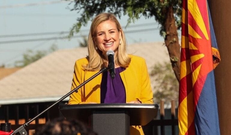
Phoenix es la quinta ciudad más grande y la metrópolis con mayor índice de crecimiento de los Estados Unidos. Kate Gallego es la segunda alcaldesa mujer electa en la historia de Phoenix; y, con sus 39 años, es la alcaldesa de una ciudad importante más joven del país. Según ella, orientar este crecimiento implica priorizar la diversidad económica, las inversiones en infraestructura y la sustentabilidad. Cuando estaba en el ayuntamiento de Phoenix, dirigió la campaña para aprobar un plan de transporte en toda la ciudad que se prolonga hasta 2050. Cuando este se aprobó, en 2015, fue el acuerdo más grande del país de un gobierno local sobre infraestructura de transporte. Antes de dedicarse a la política, Gallego trabajó en desarrollo económico para Salt River Project, un servicio público de agua y electricidad sin fines de lucro que atiende a más de dos millones de personas en el centro de Arizona. Poco después de haber sido electa por segunda vez, la alcaldesa Gallego habló con Anthony Flint, nuestro miembro sénior. Fue la primera de una serie de entrevistas por el 75.º aniversario con alcaldes de ciudades que tienen una importancia especial para el Instituto Lincoln. A continuación, se presenta la transcripción editada de la conversación.
Anthony Flint: La felicito por la reelección. ¿Cuáles cree que son los temas que más motivaron al electorado en estos tiempos turbulentos?
Kate Gallego: El electorado buscaba candidatos que pudieran liderar en función de datos reales y tomar decisiones basadas en la ciencia. Yo llego a este puesto con un historial en desarrollo económico y un título de grado en medioambiente. El profesor de química nos decía que cuantos más cursos de química hiciéramos, más lejos estaríamos de avanzar en política electoral. Pero creo que el 2020 puede haber sido un año distinto: la ciencia fue importante para el electorado . . . El electorado de Arizona quería dirigentes que se tomaran la COVID-19 en serio, al igual que otros desafíos como el cambio climático y la recuperación económica.
Particularmente para el sector más joven, el cambio climático era un asunto muy importante. Me postulé cuando la comunidad sufría el verano más caluroso que se hubiera registrado. Puede que en algunas comunidades el cambio climático sea un tema del futuro, pero en Phoenix es un problema al que nos enfrentamos ahora. Las distintas generaciones lo describen de distintas formas. Mi papá me dice: si puedes hacer algo para aliviar el calor que sentimos durante el verano aquí, seguro saldrás reelecta. Es otra visión, pero creo que el resultado es el mismo.
AF: ¿Cómo afectó la pandemia a las labores de planeamiento urbano? ¿Surgieron oportunidades imprevistas?
KG: La pandemia realmente cambió el modo en que la gente interactúa con su comunidad. Aumentaron los paseos en bicicleta y a pie. Lo que la gente nos dice es que antes no se daba cuenta de cuánto disfrutaba esa forma de moverse en la comunidad, y pretende mantener algunos de esos cambios de conducta . . . Estamos evaluando cómo podemos crear más espacios públicos. ¿Podemos expandir la gastronomía al aire libre y permitir a la gente interactuar más entre sí?
El Dr. Anthony Fauci nos dijo que cuanto más tiempo pasemos al aire libre mejor combatiremos la COVID-19. Pero hay otros beneficios muy buenos. Soy la alcaldesa de la ciudad con mayor superficie de parques en todo el país, y este fue un año récord en que se disfrutaron esos parques . . . Puedes estar en el medio de Phoenix haciendo senderismo, y hay días en los que no ves a nadie más. Este año, esos servicios y el enfoque en la planificación en función de los parques mejoraron mucho.
Además, seguimos invirtiendo en el sistema de transporte. Decidimos acelerar la inversión en transporte; esa decisión se debatió mucho, y creo que nos permitirá avanzar hacia una forma más urbana. En realidad, notamos un aumento en la demanda por vivir en la ciudad. En el centro tenemos más grúas que nunca, y a menudo vemos solicitudes para edificios más altos que los que hemos visto hasta ahora. Comprendo que se está dando un diálogo intenso a nivel nacional acerca de si la gente querrá estar en un entorno suburbano, pero hoy en el centro de nuestra ciudad el mercado apunta hacia otro lado.
La COVID-19 también nos hizo observar algunos desafíos clave de nuestra comunidad, como viviendas asequibles, la brecha digital y la seguridad alimentaria, y también hicimos inversiones importantes en esos sentidos.
AF: Quizás mucha gente piense que Phoenix tiene mucho espacio para viviendas unifamiliares, que una casa con un patiecito y una entrada para automóviles es relativamente asequible. Sin embargo, la ciudad tiene un problema importante de sinhogarismo. ¿Cómo se llegó a eso?
KG: Phoenix compite por la mano de obra con ciudades como San Francisco y San Diego, y otras con costos de vivienda mucho más elevados que los nuestros. Pero las viviendas asequibles han sido un verdadero desafío para nuestra comunidad. Phoenix presentó el mayor índice de crecimiento del país. Si bien los ingresos aumentaron bastante, no se actualizaron a la par de los grandes aumentos en costos hipotecarios y de alquiler que sufrió la comunidad. Es bueno que la gente esté entusiasmada con nuestra ciudad y quiera ser parte de ella, pero ha sido muy difícil para el mercado inmobiliario.
El concejo acaba de aprobar un plan de viviendas asequibles que incluye un objetivo de crear o conservar 50.000 unidades durante la próxima década. Estamos analizando varias políticas como herramientas, y, si queremos obtener las unidades necesarias, las viviendas multifamiliares tendrán que conformar una gran parte de la solución. Es posible que esto también nos acerque a una forma de desarrollo más urbana.
AF: Quienes se opusieron a la reciente expansión del metro ligero argumentaron que sería demasiado costosa, pero también parecía haber cierta respuesta cultural negativa hacia ese tipo de urbanización. ¿Qué pasó con eso?
KG: En repetidas ocasiones, el electorado votó a favor del sistema de metro ligero. La última vez fue una propuesta de plebiscito [para prohibir el metro ligero] en 2019, poco después de que fui electa. Esto fracasó en todos los distritos del concejo: fracasó en el distrito más demócrata y también en el más republicano de la ciudad. El electorado transmitió un mensaje rotundo: desea esa forma de desarrollo más urbana y la oportunidad que trae el sistema de metro ligero. Hubo inversiones importantes en recursos de atención médica y viviendas asequibles junto al metro ligero. Además, algunos distritos escolares pueden invertir más en aulas y salarios docentes porque no deben pagar el transporte de tantos estudiantes. Fue muy gratificante ver el impacto del metro ligero en la ciudad, cuando las empresas vienen a nuestra comunidad. Suelen pedir ubicaciones junto al metro ligero porque saben que es un servicio que el personal valora. Entonces lo considero un éxito, pero sé que seguiremos hablando sobre cómo y dónde queremos crecer en Phoenix.
AF: No podemos hablar de Phoenix y Arizona sin hablar de agua. ¿En qué estado se encuentran las conversaciones sobre innovación, tecnología y conservación para administrar ese recurso?
KG: Hablando de la ambición del electorado, este aprobó un plan para que la ciudad de Phoenix establezca el objetivo de ser la ciudad desértica más sustentable. La conservación del agua siempre fue un valor aquí, y lo seguirá siendo. La ciudad ya reutiliza casi toda el agua residual en cosechas, humedales y producción energética. Desarrollamos programas sólidos para depositar y reconvertir agua, eficiencia y conservación, y muchos de ellos sirvieron como modelo para otras comunidades.
Estamos planificando a futuro. Muchas partes de la ciudad dependen del río Colorado, y ese sistema fluvial sufre sequías, y quizás se enfrente a mayores desafíos en el futuro. Entonces, intentamos planificar a futuro e invertir en infraestructura para responder a eso, pero también consideramos el ecosistema de bosques y otras soluciones para asegurarnos de que podamos seguir entregando agua y dar prioridad al problema del cambio climático. También tuvimos suerte con bonos verdes y de sustentabilidad, que la ciudad emitió hace poco. Era hora de invertir en la infraestructura, y . . . las asociaciones con The Nature Conservancy y otras organizaciones nos ayudaron a analizar cómo gestionar el agua de modo que se aproveche el ecosistema natural, ya sea por filtración de agua pluvial o la manera en que diseñamos las soluciones del pavimento. Así, hemos tenido buenas innovaciones. La comunidad incluye muchas empresas que están a la vanguardia del uso del agua, tal como se esperaría de una ciudad desértica, y espero que Phoenix se ponga al frente y ayude a otras comunidades a abordar dificultades relacionadas con el agua.
AF: Por último, si nos da el gusto: el fundador creó la Fundación Lincoln en 1946 en Phoenix, donde participaba en acciones filantrópicas locales. ¿Nos daría su opinión sobre el modo en que se entrelazan las historias de Phoenix, la familia Lincoln y esta organización?
KG: Por supuesto. La familia Lincoln tuvo un impacto inmenso en Phoenix y nuestra economía. Uno de los puntos de mayor crecimiento en lo que respecta al empleo es la atención médica, y la red HonorHealth debe su legado a John C. Lincoln. El Centro Médico John C. Lincoln invirtió y nos ayudó en muchos aspectos, desde la COVID-19 hasta todas las dificultades que tiene una ciudad que crece rápido.
Quiero destacar a un miembro en particular de la familia: Joan Lincoln, una de las primeras mujeres a cargo de una ciudad de Arizona [fue alcaldesa de Paradise Valley entre 1984 y 1986; Joan era la esposa de David C. Lincoln, director del Instituto Lincoln por mucho tiempo, y madre de Kathryn Lincoln, la directora actual]. Cuando decidí postularme como alcaldesa, ninguna de las 15 ciudades más grandes del país tenía una alcaldesa mujer; muchas ciudades importantes, como Nueva York y Los Ángeles, nunca habían tenido una. Pero en Arizona es algo común. No soy la primera alcaldesa [mujer] de Phoenix, y soy una de las muchas alcaldesas [mujeres] que hay en el valle. Cuando Joan allanó el camino, no era así. Fue una pionera increíble de verdad, y logró que fuera más posible y más común que hubiera candidatas como yo. Agradezco su liderazgo.
Anthony Flint es miembro sénior del Instituto Lincoln de Políticas de Suelo y editor colaborador de Land Lines.
Fotografía: Kate Gallego. Crédito: Kate Gallego/Twitter.
This article is copublished with the American Planning Association’s Planning magazine.
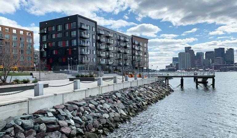
After a severe winter storm in 2018, a dumpster broke free of its moorings in Boston’s warehouse district, and started floating, almost serenely, down a flooded street. Someone captured the scene on video and it went viral, prompting headlines that the rapidly developing area should be renamed the “Inundation District.”
For the planners, engineers, and others in eastern Massachusetts who have been working to prepare for the inevitable impacts of climate change—a projected 40 inches of sea level rise, and the creeping storm surge and high-tide flooding that comes with it—there have been no shortage of such omens. The constant reminders of a wetter future suggest a race against time for a place rated the 8th most vulnerable among coastal cities worldwide, in the company of New York, New Orleans, and Miami.
While reducing carbon emissions is ongoing — Massachusetts recently passed a climate bill with firm net-zero limits for 2030 and beyond — the business of building resilience has been a priority for Boston and surrounding communities for the last several years. The looming crisis is made clear in maps projecting flooding over low-lying areas and all the extensive filling of tidal flats and marshes and other land creation that has been done over centuries. Without action, thousands of acres could be underwater, destroying homes and businesses in a terrifying transformation of the metropolitan region.
The work has been, by necessity, at the local level, without a federal organizational framework, guidance, or funding for the last four years. “With the absence of the federal government, cities like Boston have really had to step up and chart their own path in climate planning and climate resilience,” says Deanna Moran, AICP, director of environmental planning at the Conservation Law Foundation. That has meant doing careful measurement of where the flood paths are and what neighborhoods are most vulnerable, which has helped establish a detailed blueprint for targeted interventions. (Indeed, Boston is hardly alone, as is noted in APA’s Climate Change Policy Guide. “Planners have the expertise, perspectives, and skills to lead the local and regional responses to the climate crisis — but require federal and state action to amplify local planning efforts.”)
Now, with the COVID stimulus bill and another $2 trillion infrastructure package being debated in Washington, the Boston region finds itself at a pivotal moment. Funding for large-scale measures may be on the way, but that has also ratcheted up the pressure to make the right choices for effective and long-lasting protection. Confronting sea level rise here has become an extraordinary puzzle of private development, government regulation, concerns about equity, and the prospect of some areas being restored to a natural state, ultimately requiring people and places to relocate.
Years in the making
Like many coastal communities under threat, Boston has gone through early iterations of what to do, including a giant barrier stretching from Hull in the south to Winthrop in the north, protecting Boston Harbor. A 2018 study concluded the $9 billion proposal would not be cost-effective. Design competitions run by the Boston Society of Architects and the Urban Land Institute have also produced futuristic schemes like turning Back Bay streets into canals.
The search for innovative solutions continues still in the spirit of trial and error, but much of the work has settled into more down-to-earth measures: raising streets, building berms and barriers, and putting in emergency flood gates that can be deployed before a storm, for example—all based on a more precise knowledge of where the water actually goes, when it penetrates the inlets and low-lying areas in the most flood-prone areas.
Boston has already overhauled parks in the Seaport and the North End, to protect recreational facilities by giving the water different places to go. A similar approach is envisioned at Joe Moakley Park in South Boston, set to be protected by a long berm and sand dunes along the nearby beach, as a first line of defense; beyond that, flooding will be managed through a kind of re-ordering of land forms, steadily rising in elevation like a series of terraces. The playing fields can absorb some water, but the goal is to keep them as functional open space.
In addition, zoning, building codes and guidelines, and other land-use regulations are being adjusted to encourage floodable basements and parking garages, and moving mechanicals to higher elevations. Boston published a draft of Coastal Flood Resilience Design Guidelines in 2019 to begin to tackle better building design—although in terms of strict rules, local governments can’t exceed the statewide building code. Developers are also being asked to pitch in by recreating natural systems that act like a sponge, seen in the living shoreline experiment adjacent to the luxury residential development Clippership Wharf in East Boston.
Flooding knows no boundaries
Under the administration of Mayor Martin J. Walsh, who has since become U.S. labor secretary in the Biden administration, the city of Boston has led the way in climate adaptation, with the initiatives Resilient Boston Harbor, concentrating on 47 miles of shoreline, and the broader program Climate Ready Boston. (The Climate Ready Boston Report received a National Planning Achievement Award for Resilience — Gold from APA in 2019.) Yet it is readily apparent to everyone working in resilience that efforts need to be coordinated across multiple municipalities and coastal jurisdictions, since flooding doesn’t care where the town line is.
“The goal is to have a statewide flood risk model and everyone is planning for those same risks,” says Richard McGuinness, Boston’s deputy director for Climate Change and Environmental Planning. “Whether it’s Dorchester down to Quincy, or the flood paths coming into East Boston from Winthrop and Revere — regionally we see the need to determine where the action should occur. The ocean is an infinite source of water.”
McGuinness envisions a series of interventions similar to Frederick Law Olmsted’s Emerald Necklace — at its core a sanitation and flood-control public works project — extending across jurisdictional boundaries.
Frederick Law Olmsted created the Emerald Necklace by transforming a sewage-clogged swamp into parkland. Credit: 1894 map courtesy National Park Service/Olmsted Archives.
Although Massachusetts cities and towns are famously decentralized, especially in land use, a framework for regional collaboration is already in place: the Metropolitan Mayors Coalition, representing 15 eastern Massachusetts communities and 1.4 million residents, established by the Metropolitan Area Planning Council, the regional planning agency for Greater Boston.
The fiscal implications of rising seas will also get even more complicated if individual municipalities attempt to go it alone, according to Linda Shi, assistant professor at Cornell University’s department of city and regional planning.
The rules on coastal development in the 21st century simply can’t vary from one town to the next, and in fact, she says, larger-scale regional measures like the transfer of development rights and relocation through land assembly or land readjustment will be necessary. Individual nature-based solutions are fine, Shi says, but ultimately the coming transformation of coastal communities requires a broader consideration of land policy. The metaphor she invokes is a larger sheet cake, rather than individual cupcakes here and there.
A similar concern is threaded through the matter of equity. All along the East Boston waterfront, new high-end development can prompt the one-two punch of gentrification and potential flooding impacts that could get past the new building and swamp the working-class neighborhood two blocks inland, says Magdalena Ayed, founder and executive director of The Harborkeepers, a grassroots coastal resilience organization. A more uniform standard is needed to spell out the obligations of private developers to help protect the community at large, she says.
Planning, and more specifically scenario planning, can help clarify all the tricky elements inherent in building climate resilience, says Amy Cotter, director of climate strategies at the Lincoln Institute of Land Policy. “We can wait for different events to happen and react as best we can at the time, accepting the immediate loss of property and life and the cumulative effects on our communities and prosperity,” she says. “Or we can think through the different ways in which climate change will be felt and prepare for them, increasing our ability to withstand them and bounce back, and guarding against the unintended consequences of snap decisions made during crisis. Scenario planning is a great way to think about what could happen and what you’ll do as different things occur and indicate the way the future is unfolding.”
Laying out different scenarios for the future of a given area can be a sobering exercise, but one that reveals the wisdom — and the cost — of resilience interventions. Cornell’s Shi put together a case study for the town of Hull, Massachusetts, a seaside community south of Boston on the front lines of rising seas, that projects outcomes of a range of actions, from doing nothing, building a seawall, micro-protection measures like elevating homes and businesses, or pulling back to higher ground and restoring natural ecosystems. Projected costs ranged from $600 million to over $2 billion, further clarifying the stark realities of the challenges such coastal communities are facing.
A 2019 case study outlined scenarios for 2060 for Hull, Massachusetts. It showed that staying in place and just elevating roads and buildings would cost the city more than $98.8 million and single-family homeowners more than $145 million. Photo Credit: Courtesy of Howderfamily.com.
Though unpleasant, facing up to the massive disruption that rising seas will bring is critical to ensure the long-term effectiveness of resilience measures — in contrast to doing just enough to buy time. In his new book, Moving to Higher Ground: Rising Sea Level and the Path Forward, oceanographer John Englander praises the Boston area’s resilience planning — but argues it doesn’t go far enough. (Read the Planning book review.)
“Boston really is as good as it gets in the U.S. I hold up Boston and Singapore as places that are thinking futuristically,” Englander said in a recent interview. But, he adds, a truly sophisticated approach would be to plan for not three and a half feet of sea level rise, but 10 feet, over a 100-year time frame. “As good as Boston’s current plan is — and it is among the best in the world at the moment — they’re not thinking big enough. Nobody’s thinking big enough.”
As radical as some engineering solutions may sound at the moment, they could be made to be adaptable—even something as simple as the foundation of a bridge being designed to relatively easily increase its clearance as necessary. Building in that kind of flexibility in the design of infrastructure is increasingly accepted practice; what is required is a further conceptual leap, on a topic that already strains the imagination. So it is that the last few years of planning and policymaking around climate resilience, as earnestly as it has been undertaken over the last several years, is just a start.
Anthony Flint is a senior fellow at the Lincoln Institute of Land Policy and a contributing editor of Land Lines.
Photograph: A luxury residential development in East Boston sits in one of several flood paths the city has identified. Developers have raised elevations and re-created natural systems to help absorb inundation, but some wonder whether it will protect residents of the working-class neighborhood two blocks inland. Credit: Photo courtesy Anthony Flint.