Muriel Bowser alcanzó un protagonismo nacional este año por ser una voz destacada en la pandemia del coronavirus y el movimiento por la justicia racial. Bowser fue electa alcaldesa de Washington, DC, en 2014 y reelecta en 2018. Es una gran defensora del movimiento por otorgar categoría de estado a DC y ocupa un cargo único: es gobernadora y directora ejecutiva de condado, y también alcaldesa. Desde que asumió su cargo, ha buscado acelerar la producción de viviendas asequibles en el Distrito, que alberga a 706.000 personas en 176 kilómetros cuadrados y cuenta con un presupuesto de US$ 16.000 millones. Además, trabajó para diversificar la economía local, aumentar la satisfacción con los servicios de la ciudad e invertir en programas y políticas que apoyen a las familias. Bowser nació y creció en DC, inició su carrera política en 2004 como comisionada asesora de vecindarios para el barrio Riggs Park y en 2007 entró en el concejo del Distrito Electoral 4. Hace poco, nos cedió un tiempo de su agenda de alcaldesa de la capital de la nación para conectarse por correo electrónico con Anthony Flint, miembro sénior del Instituto Lincoln.
Anthony Flint: Asumió su cargo a principios de 2015. ¿Hubo algo que la pudo haber preparado para el 2020? ¿Cómo ve que se desarrollará lo que queda de este año turbulento? ¿Confía en la gestión ante el coronavirus?
Muriel Bowser: Como ciudad global, nos preparamos constantemente para un abanico de impactos y tensiones. Sin embargo, está claro que este es un evento inaudito que exigió una respuesta inaudita. Los residentes y las empresas hicieron sacrificios tremendos por la salud y la seguridad de la comunidad. Como Distrito, tenemos la suerte de que encaramos la crisis desde una posición de fortaleza. Eso nos permitió empezar a implementar muchos recursos de inmediato para proteger y apoyar a los residentes, como entregar alimentos para personas mayores, crear sitios de distribución gratuita de productos de almacén para quienes los necesitaran o establecer sitios de pruebas gratuitas en toda la ciudad y contratar enseguida cientos de rastreadores de contacto. Desde que comenzó la emergencia, nos hemos centrado mucho en seguir a la ciencia, oír a los expertos y mantener informada a la comunidad. Ojalá eso continúe hasta que podamos superar esto. Pero en general, estoy muy orgullosa de cómo respondió la población de Washington al desafío.
AF: ¿Qué expresa el mural de “Las vidas negras importan” sobre la calle 16th Street frente a la Casa Blanca (replicado en muchas otras ciudades) sobre la dinámica del dominio público y el cambio social?
MB: Decidí crear el Paseo “Las vidas negras importan” cuando las protestas pacíficas contra el racismo sistémico se encontraron con gas lacrimógeno, helicópteros federales y soldados camuflados ocupando nuestras calles locales. Y lo que hicimos fue crear un lugar donde la población estadounidense pudiera unirse para protestar y reparar, para crear estrategias y sanar. La población de todo el país se volcó a la calle para exigir un cambio. Ya sea mediante protestas o arte, o una combinación de protestas y arte, la gente está usando el dominio público para enviar un mensaje claro: que las vidas negras importan, que la humanidad negra importa, y que debemos saldar esta cuenta y reparar los sistemas rotos que perpetúan el racismo y la injusticia desde hace demasiado tiempo.
AF: En 2019, estableció un objetivo para 2025, de crear 36.000 unidades de vivienda nuevas (12.000 de ellas asequibles). ¿Cuáles son las cosas esenciales que deben ocurrir para crear más opciones de vivienda en Washington?
MB: Cuando asumí el cargo, llevamos a más del doble la inversión anual en el Fideicomiso para la Producción de Viviendas de DC, a US$ 100 millones al año. Es el mayor valor per cápita de todas las jurisdicciones. Y no solo estamos invirtiendo: estuvimos sacando ese dinero y poniéndolo en proyectos que producen y conservan miles de viviendas asequibles en toda nuestra ciudad. Pero debemos hacer más. Como usted destacó, en DC tenemos un objetivo grande: construir 36.000 viviendas nuevas para 2025, y que al menos un tercio de ellas sea asequible. El año pasado, nos convertimos en la primera ciudad de la nación en establecer metas de vivienda asequible por vecindario. Cuando anunciamos esas metas, también organizamos conversaciones comunitarias en vecindarios de toda la ciudad para debatir con los residentes sobre el legado persistente de las diversas prácticas discriminatorias y sobre cómo podemos trabajar en conjunto para mejorar. Algunas de las medidas que estamos tomando para lograrlo son: una reducción impositiva en zonas de alta necesidad, cambios en el programa de zonificación inclusiva y continuar con esas inversiones grandes (y estratégicas) del Fideicomiso para la Producción de Viviendas.
AF: Si la economía de la ciudad se recupera de la pandemia, es probable que Washington continúe con su historia de logros con relación al renacimiento urbano. ¿Qué políticas implementó para abordar el aburguesamiento y el desplazamiento, tanto residencial como comercial?
MB: Sé que Washington se podrá recuperar de esta pandemia. Aún tenemos más de 700.000 habitantes que tienen capacidad de recuperación y creatividad, y se centran en ayudar a sus pares a superar la situación; sobre esa base, sé que superaremos esto.
Cuando entramos en emergencia sanitaria pública, ya nos centramos mucho en construir una ciudad más inclusiva y procurar que los beneficios de nuestra prosperidad llegaran a más habitantes. Esta pandemia no hizo más que amplificar la importancia de nuestras labores por la igualdad. Y al avanzar con la respuesta y la recuperación, aún nos centramos en cómo nos acercamos a nuestras metas de vivienda, empleo, atención médica y más. Seguimos invirtiendo más de US$ 100 millones en viviendas asequibles. Estamos avanzando con nuestro plan estratégico para lograr que no haya más personas sin hogar, y abrimos refugios nuevos y más dignos en toda la ciudad. Los programas para adquirir una vivienda continúan. Observamos los números reales de las viviendas para ver cómo podemos ayudar a más residentes a quedarse y construir su futuro en DC.
Y también apoyamos a las pequeñas empresas y los emprendedores locales. Por ejemplo, hace poco anunciamos una nueva estrategia de inclusión equitativa que aumentará el acceso a oportunidades de desarrollo para organizaciones que pertenecen de forma total o mayoritaria a individuos de la población en desventaja social.
AF: ¿Qué tipo de importancia atribuye a la oficina de planificación de su ciudad, y por extensión, quién se está desempeñando bien en la práctica de planificación en otras ciudades?
MB: Es esencial no solo que planifiquemos para el crecimiento a largo plazo de DC, sino también que procuremos que el crecimiento refleje los valores de una ciudad inclusiva y dinámica. Mi Oficina de Planificación tiene un papel crucial en la promoción de nuestras metas de viviendas, y nos ayuda a construir una ciudad que trabaja para la población de todos los entornos y niveles de ingresos. Dado que la oficina de planificación puede ofrecer análisis de políticas, hacer consideraciones a largo plazo y tener un alcance comunitario, además de encargarse de las necesidades de implementación en cuanto a la zonificación y el uso territorial, para mí es uno de los organismos de la vivienda. Trabajan junto con el departamento de vivienda tradicional, la autoridad de viviendas sociales y el organismo de financiamiento de viviendas para analizar las viviendas y la capacidad de pago.
Respecto de otras ciudades, lo que es interesante es que en todo el país también están pasando muchas cosas fantásticas a nivel local, y las ciudades y los pueblos están creando soluciones innovadoras que están a la altura de sus necesidades únicas, desde Los Ángeles hasta Gary, Indiana, y Boston. Las ciudades son incubadoras de innovación, y si bien no siempre tenemos los mismos desafíos (por ejemplo, algunas ciudades tienen muchas personas y pocas viviendas, y otras tienen muchas viviendas y pocas personas), siempre estamos aprendiendo unas de otras.
AF: ¿Qué pueden hacer las ciudades ahora para enfrentar la crisis climática, que sigue avanzando, aunque en este momento esté eclipsada por las otras emergencias que estuvieron ocupando lugares más protagónicos?
MB: La justicia medioambiental debe ser parte de la conversación más amplia que tenemos a nivel nacional en este momento. Por ejemplo, sabemos que el daño causado por el cambio climático antropogénico tiene un impacto desproporcionado en las comunidades de color. Además, cuando observamos el impacto desproporcionado que la COVID-19 tiene en las personas negras estadounidenses, vemos el vínculo directo con el trabajo que debemos hacer para construir comunidades más saludables y con mayor capacidad de resistencia. Es toda una conversación sobre igualdad y justicia. En DC tenemos varios programas, como Solar for All, que se centran en combatir el cambio climático y a la vez responder a la desigualdad y otras disparidades. No debemos aislar estas problemáticas; podemos y debemos centrarnos en todo.
Fotografía: La alcaldesa Bowser observa el mural de “Las vidas negras importan” que encargó para la calle 16th Street, que lleva directo a la Casa Blanca. Crédito: Khalid Naji-Allah.
Regional Visioning
Utah's Wasatch Front Region Reflects on Two Decades of Scenario Planning
By Emma Zehner, Dezembro 16, 2020
SHARE
In the late 1990s, the 10-county Greater Wasatch area of Utah faced the prospect of rapid population growth. Experts projected that by 2020, one million new residents would migrate to cities along the 140-mile-long urban corridor hugging the western edge of the Rocky Mountains and anchored by the state capital, Salt Lake City. The influx would represent a nearly 60-percent increase in population for the region, already home to four in five Utahns.
In an effort to plan for this growth, planners, developers, local government officials, and business leaders embarked on an exhaustive multiyear public outreach campaign, ultimately engaging more than 18,000 residents to develop a collective vision for 2020, with funding from foundation, corporate, and local and state government sources. The result was the Quality Growth Strategy, which has informed policy related to air quality, transportation, water use, housing, and more, in the ensuing decades.
Envision Utah, the nonprofit formed as a result of this effort, recently assessed how close the region came to achieving its vision. The region has progressed in all areas of the plan, to different degrees. Similar to predictions, the population grew by about 954,000 residents. On the issue of transit, the number of people living within a half-mile of a transit stop was about 260,000 higher than if the region hadn’t changed the growth strategies it was using in the 1990s, but 300,000 people short of the goal of 608,000. On land use, if growth had continued along the same trajectory it was on in the 1990s, 130 new square miles would have been developed each decade. However, using tools identified in collaboration with the public to preserve open space and avoid sprawl, the region saw only 63 square miles of additional development per decade, saving an estimated $4.5 billion in infrastructure maintenance.
Scenario Planning for Public Engagement
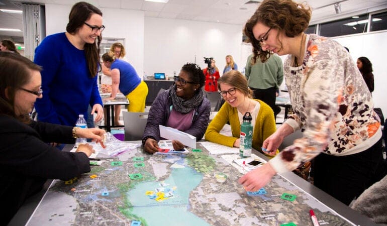
At the center of the project in 1998 was a process called scenario planning, a practice that guides planners, community members, and other stakeholders through considerations of various futures and how to effectively respond to and plan for them. At the start of Envision Utah, leaders engaged the public in the development of several scenarios. During meetings, participants worked together, using tokens to indicate their growth preferences on printed maps. From there, outside consultants extracted common patterns and developed them into four future scenarios—ranging from the continued development of single-family homes and auto-centric infrastructure to walkable communities clustered around town centers. Scenario C, which represented a walkable future, emerged as the clear favorite, based on 17,500 survey responses from the community and additional input from in-person meetings. In the final stage of public outreach, residents ranked the strategies they thought the region should use to get to this scenario, which were incorporated into the final vision.
Since the initial Envision Utah effort, scenario planning has become an increasingly valued tool, in Utah and nationwide, for engaging the public and gaining buy-in. Scenarios allow planners to present data to the public that shows cause and effect, says Ryan Beck, the current vice president of planning at Envision Utah, which still uses scenario strategies in most of its current projects. Beck explains that planners can show the benefit of an approach without using without using technical terms that can be confusing and sometimes politically divisive.
“If you put real data in front of people and real outcomes, it is hard not to make a good decision,” Beck said.
Envision Utah also benefits from its role as a neutral, non-partisan facilitator. The visions and implementation strategies that emerge from Envision Utah’s processes are recommendations, and local officials can choose whether and how to implement them. “It doesn’t feel like anyone is telling them what to do,” Beck said. “That makes it more palatable.” This can help with tensions that sometimes arise between regional planning visions and a desire for local control, Cody Lutz, associate planner at Envision Utah, explained.
By combining factors like transportation and water demand, scenario planning is also a useful way to demonstrate the relationships between different sectors. “By engaging in scenario planning, we are able to think about the interactions between systems that don’t always get treated together,” said Ted Knowlton, deputy director at Wasatch Front Regional Council (WFRC), the Metropolitan Planning Organization for the Salt Lake region. WFRC is cohosting the Lincoln Institute’s upcoming Consortium for Scenario Planning Conference from January 13 through 15. “Transportation infrastructure ideas don’t always think about land use planning changes, real estate market impacts, but they should. That is the way the world actually works.”
Evolution of the Practice
In the years since Envision Utah, scenario planning has become baked into many planning processes in the state. “I think that each time it has happened, it has converted over more skeptics,” Knowlton said. “People have gotten to learn that this is the way to do good planning.“It has become the way of operating in Utah.”
Along the way, practices and tactics have evolved. In place of newspaper ads and radio interviews, planners rely more heavily on social media to reach constituents. Older software and spreadsheet-based modeling tools have been replaced with platforms like UrbanFootprint, a GIS-based scenario planning tool.
Beck explained that, as tools have evolved, outputs have become more reliable. At the same time, Knowlton acknowledged, weakened news infrastructure and an increase in unreliable information has led to some resistance to trusting data that would have been accepted in the past.
Knowlton says that an enduring challenge is convincing members of the public that it is important to start thinking decades into the future. “Even if residents care about the future, they don’t always realize that we are actually talking about decisions that need to start being made now so that over time we get to the [desired] future.”
One tool Knowlton said can be helpful in making the planning process seem immediate and real is having residents focus on smaller areas, such as 15-by-15 mile areas, when evaluating scenarios. “This helps people tie a regional story to a scale with which they are more familiar,” Knowlton added.
Current Work
Envision Utah and the Wasatch Front Regional Council, which often collaborate are currently using scenario planning in a range of ongoing projects.
Both worked with business representatives, educational institutions, and local governments, on the recent 2050 visioning process for Point of the Mountain, an area that sits at the intersection of Wasatch Front’s Salt Lake and Utah County metropolitan areas. The resulting vision would establish the area as a high-tech economic hub, adding 150,000 jobs and increasing incomes, and significantly increasing the number of jobs accessible by transit. The transit strategies that came out of this visioning process were incorporated into the Wasatch Front Regional Council Regional Transportation Plan.
Other projects include Your Utah, Your Future, which used 52,000 survey responses to develop a 2050 statewide plan, and Valley Visioning, a plan for Utah County, one of the counties in the Wasatch Front region, which Envision Utah representatives will discuss at the Consortium for Scenario Planning conference in January.
“We don’t have lessons learned in every aspect of scenario planning,” Knowlton said. “But in some places, like process design and the use of scenarios in a broader campaign, there is quite a bit that we can offer to other places trying to do similar projects.”
Registration for the Consortium for Scenario Planning conference, which will be held virtually January 13-15, is currently open, and includes all conference sessions, presentations, and networking events, as well as access to session recordings for three months following the conference. The conference includes tracks for all levels and interests and features a wide range of scenario planning applications, from pandemic and economic recovery to climate and natural hazards planning to planning for low-growth and legacy cities.
Emma Zehner is communications and publications editor at the Lincoln Institute of Land Policy.
Photograph: Participants at a public workshop for the Valley Visioning plan. Credit: Nathan Brown, Envision Utah.
El curso aborda la segregación de la vivienda de los más pobres, los factores que la causan, sus efectos nocivos y las oportunidades que ofrecen las políticas de vivienda social integrada. Se analizan ideas comunes que favorecen la segregación en las ciudades, tales como la atención casi exclusiva a la formalidad en el acceso a la vivienda, la relación entre la desigualdad y la forma urbana, los efectos de la mezcla social en el valor de las propiedades y el comportamiento de los mercados inmobiliarios. También se examina la participación de las personas, las empresas y el gobierno en las políticas habitacionales, y se debaten conceptos y experiencias de programas públicos de viviendas socialmente integradas en diferentes países.
Relevancia
Las políticas tradicionales de vivienda social restan importancia a la segregación y privilegian exclusivamente el acceso a la vivienda formal. Sin embargo, la segregación espacial reduce las oportunidades de familias y grupos vulnerables, y suele agravar problemas sociales como la violencia, la deserción escolar y el tráfico de drogas. Una buena localización trae oportunidades, mientras que una mala conlleva obstáculos. Ambas suelen ser el resultado de distintas acciones y políticas públicas, por lo que estudiar y conocer la importancia que tiene una localización no segregada puede ser crucial para mejorar las políticas de suelo y de vivienda social.
07/01/21: Las fechas del curso han cambiado, por lo que se ha extendido el plazo para postular.
Descripción
El curso aborda las alternativas que existen para enfrentar el cambio climático desde la perspectiva de las políticas de suelo, con la utilización de instrumentos de planificación, gestión y financiamiento urbano. Los contenidos se presentan de acuerdo al ciclo de la política pública. Se hace énfasis en:
la relación entre urbanización y cambio climático (cómo identificar y definir los problemas climáticos);
planificación (cómo se pueden incorporar aspectos climáticos en la planificación urbana);
gestión y financiamiento (qué instrumentos de políticas de suelo se pueden utilizar para gestión y financiamiento climático); y
monitoreo y evaluación (cuáles son y por qué son importantes las metodologías para medir y monitorear avances).
Hacia el final del curso, los alumnos realizan un taller integrador donde pueden aplicar los conocimientos aprendidos.
Relevancia
La urbanización y las actividades humanas de las ciudades producen gases de efecto invernadero con impacto en la temperatura ambiente, las precipitaciones y la capa de hielo, lo que genera islas de calor, sequías, inundaciones y aumento del nivel del mar. Esto tiene consecuencias en la infraestructura urbana, la disponibilidad de recursos básicos, y provoca la pérdida de ecosistemas y desplazamientos masivos de población, entre otros impactos. A pesar de que las emisiones de gases totales de América Latina y el Caribe representan solo el 8,3% de las mundiales, la región es particularmente vulnerable al cambio climático debido a sus características (CEPAL, 2015). En este escenario, es urgente incrementar la resiliencia ante estos riesgos y reducir las emisiones de carbono de la región, especialmente a través de la implementación de políticas de suelo para la mitigación y adaptación climática.
Phoenix is the fifth-largest city in the United States and the fastest-growing city in the country. For Mayor Kate Gallego—the second elected female mayor in Phoenix history and, at 39, the youngest big-city mayor in the United States—navigating that growth means prioritizing economic diversity, investments in infrastructure, and sustainability.
Gallego was elected in March 2019 to complete the term of a mayor who was heading to Congress, then reelected in November 2020. As a member of the Phoenix City Council, she led the campaign to pass a citywide transportation plan for Phoenix through 2050, which represented the country’s largest local government commitment to transportation infrastructure when it passed in 2015.
Before entering politics, Gallego worked on economic development for the Salt River Project, a not-for-profit water and energy utility that serves more than 2 million people in central Arizona. Just days after her reelection, Mayor Gallego spoke with Senior Fellow Anthony Flint. The interview kicks off a series of conversations with mayors of cities that are especially significant to the Lincoln Institute, which is celebrating its 75th anniversary in 2021. An edited transcript follows; listen to the full interview on the Land Matters podcast.
Anthony Flint: Congratulations on your reelection. What issues do you think motivated voters most in these tumultuous times?
Kate Gallego: Voters were looking for candidates who would deliver on real data-driven leadership and science-based decision-making. I come to this job with a background in economic development and an undergraduate environmental degree. My chemistry professor told us that the more chemistry you take, the less likely you [are] to move up in electoral politics. But I think 2020 may have been a different year where science matters to voters . . . Arizona voters wanted leadership that would take COVID-19 seriously, as well as challenges such as climate change and economic recovery.
For younger voters in particular, climate change was a very important issue. I ran for office as my community faced our hottest summer on record. In some communities, climate change may be a future issue, but in Phoenix, it was an issue facing us right now. Different generations describe it differently. So my dad tells me, if you can just do something about the heat in the summer here, you’ll definitely be reelected. A different lens, but I think the same outcome.
AF: How has the pandemic affected your urban planning efforts? Did it surface any unexpected opportunities?
KG: The pandemic really changed how people interact with their communities. We saw biking and walking more than double . . . what people tell us is they didn’t realize how much they enjoyed that form of moving about our communities, and they intend to keep some of those behavior changes . . . . We’re currently looking at how we can create more public spaces. Can we expand outdoor dining and let people interact more with each other?
Dr. Anthony Fauci has told us that the more time we can be spending outdoors, the better for fighting COVID-19. But that also has other great benefits. I serve as mayor of the city with the most acres of parks of any United States city, and this has been a record year for us enjoying those Phoenix parks . . . You can be in the middle of Phoenix on a hiking trail and some days you don’t see anyone else. So those amenities and the focus of our planning around parks has really improved this year.
We also continue to invest in our transportation system. We’ve decided to speed up investment in transit, which was a decision that we did have real debate over, that I think will allow us to move towards a more urban form. We’ve actually seen increased demand for urban living in Phoenix. We have more cranes in our downtown than ever before and we are regularly seeing applications for taller buildings than we have seen before. I understand there’s a real national dialogue about whether everyone will want to be in a suburban setting, but the market is going in a different direction in our downtown right now.
COVID-19 has also made us look at some of the key challenges facing our community such as affordable housing, the digital divide, and addressing food security, and we’ve made significant investments in those areas as well.
AF: Many might think of Phoenix as a place with abundant space for single-family homes, where a house with a small yard and driveway is relatively affordable. Yet the city has a big problem with homelessness. How did that happen?
KG: Phoenix competes for labor with cities such as San Francisco and San Diego and others, that still have a much more expensive cost of housing than we do. But affordable housing has been a real challenge for our community. Phoenix has been the fastest-growing city in the country. Although we have seen a pretty significant wage growth, it has not kept up with the huge increases in mortgages and rent that our community has faced. It’s good that people are so excited about our city and want to be part of it, but it’s been very difficult for our housing market.
The council just passed a plan on affordable housing including a goal to create or preserve 50,000 units in the next decade. We are looking at a variety of policy tools, and multifamily housing will have to be a big part of the solution if we are going to get the number of units that we need. So again, that may be moving us towards a more urban form of development.
AF: Opponents of the recent light rail expansion argued it would cost too much, but there also seemed to be some cultural backlash against urbanizing in that way. What was going on there?
KG: Our voters have voted time and time again to support our light rail system. The most recent time was a ballot proposition [to ban light rail] in 2019 shortly after I was elected. It failed in every single one of the council districts; it failed in the most Democratic precinct and the most Republican precinct in the city. Voters sent a strong message that they do want that more urban form of development and the opportunity that comes with the light rail system. We’ve seen significant investments in healthcare assets and affordable housing along the light rail. We’ve also seen school districts that can put more money in classrooms and in teacher salaries because they don’t have to pay for busing a significant number of students. We have really been pleased with its impact on our city when we have businesses coming to our community. They often ask for locations along light rail because they know it’s an amenity that their employees appreciate. So I consider it a success, but I know we’re going to keep talking about how and where we want to grow in Phoenix.
Phoenix, Arizona, is the fifth-largest city in the United States, and the fastest-growing city in the country. Credit: Jerry Ferguson via Flickr CC BY 2.0.
AF: We can’t talk about Phoenix and Arizona without talking about water. Where is the conversation currently in terms of innovation, technology, and conservation in the management of that resource?
KG: Speaking of our ambitious voters, they passed a plan for the City of Phoenix setting a goal that we be the most sustainable desert city. Water conservation has been a Phoenix value and will continue to be. The city already reuses nearly all wastewater on crops, wetlands, and energy production. We’ve done strong programs in banking water, repurposing water, and efficiency and conservation practices, many of which have become models for other communities.
We are planning ahead. We have many portions of our city that are dependent on the Colorado River, and that river system faces drought and may have even larger challenges in the future. So we’re trying to plan ahead and invest in infrastructure to address that, but also look at our forest ecosystem and other solutions to make sure that we can continue to deliver water and keep climate change front of mind. We’ve also had good luck with using green and sustainable bonds, which the city recently issued. It was time to invest in our infrastructure . . . partnerships with The Nature Conservancy and others have helped us look at how we manage water in a way that takes advantage of the natural ecosystem, whether stormwater filtration, or how we design our pavement solutions. So we’ve had some neat innovation. We have many companies in this community that are at the forefront of water use, as you would expect from a desert city, and I hope Phoenix will be a leader in helping other communities address water challenges.
AF: Finally, if you’ll indulge us: we will be celebrating our 75th anniversary soon; our founder established the Lincoln Foundation in 1946 in Phoenix, where he was also active in local philanthropy. Would you comment on the ways the stories of Phoenix and the Lincolns and this organization are intertwined?
KG: Absolutely. The Lincoln family has made a huge impact on Phoenix and our economy. One of our fastest-growing areas in terms of job growth has been our healthcare sector, and the HonorHealth network owes its heritage to John C. Lincoln. The John C. Lincoln Medical Center has been investing and helping us get through so many challenges, from COVID-19 to all the challenges facing a quickly growing city.
I want to recognize one Lincoln family member in particular: Joan Lincoln, who was one of the first women to lead an Arizona city as mayor [of Paradise Valley, 1984–1986; Joan was the wife of longtime Lincoln Institute Chair David C. Lincoln and mother of current Chair Katie Lincoln]. When I made my decision to run for mayor, none of the 15 largest cities in the country had a female mayor; many significant cities such as New York and Los Angeles still have not had one. But in Arizona, I’m nothing unusual. I’m not the first [woman to serve as] Phoenix mayor and I’m one of many [female] mayors throughout the valley. That wasn’t true when Joan paved the way. She really was an amazing pioneer and she’s made it more possible for candidates like myself to not be anything unusual. I’m grateful for her leadership.
Anthony Flint is a senior fellow at the Lincoln Institute of Land Policy and a contributing editor of Land Lines.
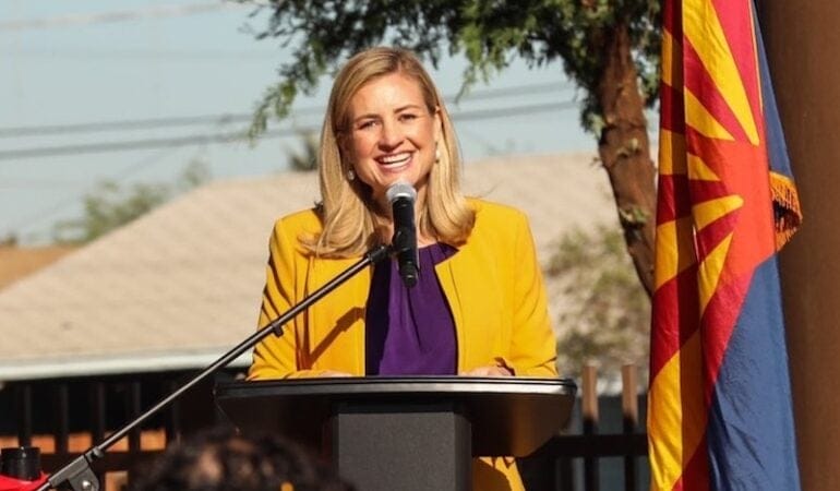
Photograph: Phoenix Mayor Kate Gallego has pursued an ambitious sustainability agenda for the city. She was reelected in November 2020. Credit: Mayor Kate Gallego via Twitter.
Lincoln Institute of Land Policy Launches Center for Geospatial Solutions
By Will Jason, Outubro 29, 2020
SHARE
The Lincoln Institute of Land Policy today launched a new enterprise to expand the use of advanced technology for land and water conservation—The Center for Geospatial Solutions (CGS). The center will give people and organizations the tools they need to manage land and water resources with precision, at the scale required to confront pressing challenges such as climate change, loss of habitat, and water scarcity.
The center will provide data, conduct analysis, and perform specialized consulting services that enable organizations of all sizes in the nonprofit, public, and private sectors to deploy geographic information systems (GIS), remote sensing, and other geospatial technologies. The center will help practitioners to overcome barriers such as a lack of staffing, resources, or expertise, which have hindered the adoption of geospatial technology, especially in the nonprofit sector.
“If land and water managers, conservationists, and governments are to meet rapidly accelerating social, economic, and environmental challenges, including climate change, they need to work together at larger scales and make use of every possible tool,” said Anne Scott, executive director for the Center for Geospatial Solutions. “The Center for Geospatial Solutions will enhance collective access to better data and analysis, so that practitioners and decisionmakers can act collaboratively on the best information available.”
The center will deliver services directly to nonprofit organizations, foundations, governments, and businesses, and will also work with funders to guide and administer grants. The center will also use the resources and expertise of the Lincoln Institute, which is organized around the achievement of six goals: sustainably managed land and water resources, low-carbon, climate-resilient communities and regions, efficient and equitable tax systems, reduced poverty and spatial inequality, fiscally healthy communities and regions, and functional land markets and reduced informality.
“My wife, Laura, and I developed Esri to help people make better decisions for our world, and that is what the Center for Geospatial Solutions is accomplishing,” said Jack Dangermond, President and CEO of Environmental Systems Research Institute (Esri). “The Center for Geospatial Solutions will move the global environmental field over the next decade to meet goals set forth by scientists to save and restore our planet. The center’s combination of partnerships, shared resources, advanced data science and analysis fills an important niche to bring geospatial technology solutions to environmental organizations worldwide.”
The center will prioritize access to technology for people and communities that have been historically marginalized, governments in the developing world, under-resourced nonprofit organizations, startups, and businesses operating in developing or restricted economies. The center will build customized tools that can be tailored to fit the size and capacity of any organization.
“These are unprecedented times, which require broad vision combined with the practical implementation of innovative solutions,” said Breece Robertson, director of partnerships and strategy for the Center for Geospatial Solutions. “We can’t address global challenges like climate change and inequity without access to data, science and technologies that enable everyone to act effectively.”
The potential for geospatial technology to improve conservation is well demonstrated. In one powerful application, regional planners in Tucson, Arizona, worked with nonprofit partners, including the Lincoln Institute’s Babbitt Center for Land and Water Policy, to map the tree canopy, surface temperatures, and other data to help communities to better-manage stormwater, and to prioritize where to plant trees. In another case, Denver’s regional planning agency is using high-resolution maps to classify land cover into eight categories for a wide range of possible uses, including to understand habitat connectivity and quality to guide investment in green infrastructure.
In addition to advancing land and water conservation, geospatial technology can inform decisions in urban contexts. Its applications include analyzing cities’ carbon footprints, exploring the conservation potential of brownfield sites, revealing local variations in air quality, and mapping parks, open spaces, and urban corridors for wildlife.
“Some organizations are already using geospatial technology to understand what is happening on the ground with greater and greater precision,” said Jeffrey Allenby, director of geospatial technology for the Center for Geospatial Solutions. “The center will bring this capability to organizations of all sizes and scales by building customized tools that are easy to use for all staff, even those with no background or training in technology.”
“The center builds on the Lincoln Institute’s long track record of pioneering ideas that have transformed land policy,” Lincoln Institute President and CEO George W. “Mac” McCarthy wrote in an essay in Land Lines, the magazine of the Lincoln Institute. “The Center for Geospatial Solutions represents another transformational idea—by making land, water, and mapping technology universal, we can enable people and organizations to collaborate and achieve impact that is orders-of-magnitude greater than what they can accomplish today. Like lifting a fog, applying geospatial technology will enable anyone to see what is happening anywhere on the Earth. It will make the planet feel that much smaller, and the solutions to humanity’s toughest problems that much easier to grasp.”
Anne brings leadership experience in public and community health and international development, and she is particularly passionate about achieving cost-effective outcomes that can be replicated and scaled. She has lived and worked in Asia, Africa, and the Middle East on the implementation and evaluation of large-scale health and environmental programs funded by the U.S. and European governments, and philanthropic foundations. Anne has held executive positions at the Children’s Investment Fund Foundation in London, the Charlottesville (Virginia) Area Community Foundation and, most recently, Boston-based Pathfinder International. She is a prior board chair of the Chesapeake Conservancy. Anne has a Ph.D. in medical anthropology and an MBA in finance, as well as post-doctoral qualifications in science and diplomacy, and health and child survival.
Jeff brings a wealth of experience developing systems-focused solutions at the intersection of technology and the natural world. Prior to joining the Lincoln Institute, Jeff was the director of conservation technology at the Chesapeake Conservancy and cofounder of the Conservancy’s Conservation Innovation Center, building it from scratch into a globally recognized pioneer in the application of technology to improve environmental decision making in the Chesapeake Bay and across the world. Jeff worked previously for the University of Maryland Center for Environmental Science and the Maryland Department of Natural Resources on projects to support local climate change adaptation. Jeff has a M.E.M. and a certificate in geospatial analysis from Duke University and a B.S. from the University of Richmond. Jeff also serves as a member of the advisory board for the Internet of Water.
Breece has more than 18 years of experience leading collaborative and strategic initiatives that leverage data-driven platforms, GIS, research, and planning for the park and conservation fields. Breece combines geospatial technology and storytelling to inspire, activate, educate, and engage. During her career at The Trust for Public Land, she led geospatial innovations that supported the protection of 3,000+ places, over 2+ million acres of land, provided park access to over 9 million people, and achieved $74 billion in voter-approved funding for parks and conservation. She is a skilled leader, collaborator, implementer, and creative visionary with a legacy of building award-winning teams and community-driven GIS approaches for strategic conservation and park creation. Esri, the world’s leader in geographic information system (GIS) technology, twice has honored Robertson for innovation in helping communities meet park and conservation goals. In 2006, she was awarded the Esri Special Achievement in GIS award and in 2012, the “Making a Difference” award – a prestigious presidential award.
About the Lincoln Institute of Land Policy
The Lincoln Institute of Land Policy seeks to improve quality of life through the effective use, taxation, and stewardship of land. A nonprofit private operating foundation whose origins date to 1946, the Lincoln Institute researches and recommends creative approaches to land as a solution to economic, social, and environmental challenges. Through education, training, publications, and events, we integrate theory and practice to inform public policy decisions worldwide.
Will Jason is director of communications at the Lincoln Institute.