For this in-person, invite-only event, the Lincoln Institute of Land Policy brings planning directors from the largest US cities to Cambridge, Massachusetts, for a three-day summit at the Lincoln Institute offices. The Big City Planning Directors Institute is a collaboration of the Lincoln Institute, Harvard University’s Graduate School of Design, and the American Planning Association. Planning directors will examine emerging public policy questions that influence the planning and design of large cities and their metropolitan regions. In 2023, the event was attended by 27 directors, representingcities from New York to Los Angeles.
Detalhes
Data(s)
Outubro 6, 2024 - Outubro 8, 2024
Local
Cambridge, MA United States
Idioma
inglês
Palavras-chave
Desenvolvimento Comunitário, Desenvolvimento Urbano
El curso presenta una aproximación general a las intervenciones urbanas de gran envergadura, denominadas usualmente Grandes Proyectos Urbanos (GPU), y busca generar una reflexión sobre los desafíos que representan para la gestión de suelo, especialmente en las ciudades latinoamericanas. En este sentido, el participante tendrá una introducción a los fundamentos de la formación de precios y al funcionamiento de mercados de suelo en América Latina, y se abordarán los impactos y desafíos que traen los GPU en el manejo del suelo. Se hará énfasis en el análisis de casos locales e internacionales de estos proyectos y sus instrumentos de planificación, financiación y gestión del suelo.
Los postulantes seleccionados aparecerán en la página Listas de Seleccionados a partir del 25 de septiembre de 2024.
Desenvolvimento Econômico, Economia, Infraestrutura, Regulação dos Mercados Fundiários, Uso do Solo, Planejamento de Uso do Solo, Saúde Fiscal Municipal, Finanças Públicas
When Claudia López took office as Bogotá’s first elected female mayor and first openly gay mayor in January of 2020, she had big plans for the Colombian capital—literally.
Chief among her campaign pledges was a promise to finally update the city’s master plan, or Plan de Ordenamiento Territorial (POT), a long-overdue goal that had eluded her predecessors for nearly two decades. López was also determined to address the city’s social debts to women and children, and to produce climate and mobility plans that would advance urban greening efforts and restart progress on the city’s metro system as part of a multimodal public transportation strategy.
Just weeks later, those ambitions took a backseat as a deadly pandemic swept the world, plunging Bogotá and so many other cities into a state of health and economic emergency.
In a matter of months, unemployment and extreme poverty tripled, wiping out two decades of socioeconomic progress. “Nobody wants to be in charge during such a crisis—it’s a nightmare, and it’s hard to do,” says López, who was term-limited out of office in 2023 and is now a 2024 Advanced Leadership Initiative fellow at Harvard University. “But every crisis opens up opportunities that were not there before.”
A citywide sense of solidarity in the face of those punishing pandemic impacts ultimately helped López galvanize support for her updated POT. And embedded within that plan was a simple yet revolutionary idea to improve gender equality—quickly, dramatically, and for years to come.
Caring About Caregivers
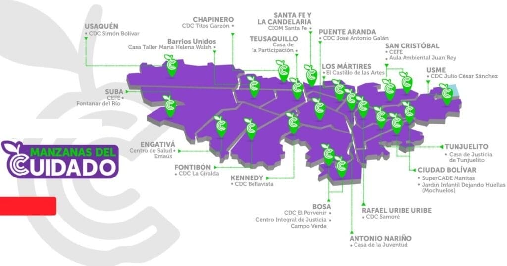
In 2020, Bogotá began to build a network of neighborhood Care Blocks (Manzanas del Cuidado). These facilities provide an array of services for nearby caregivers, most of whom are women, including access to free, professional care for their dependents—children, ailing elders, relatives with disabilities—and opportunities to take part in education, counseling, training, or wellness programs. While they are intentionally located in walkable areas, the city has also provided Care Buses for those who live farther away.
The Manitas Care Block in Ciudad Bolívar opened in 2020, the first of more than 20 new facilities in the city designed to provide services for caregivers. Credit: LLANOFOTOGRAFIA (www.llanofotografia.com).
The underlying idea, initially conceived by Diana Rodríguez Franco, the city’s former secretary for women’s affairs, was to offer much needed relief, respect, and opportunity for the caregivers whose invisible labor keeps the rest of the city running.
Thirty percent of women in Bogotá, 1.2 million people, are full-time caregivers who average 10 hours a day of unpaid labor. Most live in poverty and haven’t had a chance to pursue an education beyond primary school or start a career, denying them the opportunity for economic autonomy.
“That, in Bogotá, seems normal, because of religion, machismo, cultural norms,” López says. “It’s so ingrained in society that this overburden is normal. So [we are] saying, ‘That’s not normal. That is not ethically normal, it’s not socially normal, it cannot be economically normal—it’s actually counterproductive for society that we lose 52 percent of the labor force. So we’re going to change that.’”
Colombia had passed a first-of-its-kind law in 2010 requiring the government to track the economic value of unpaid care work, finding that the care economy represents 20 percent of the nation’s gross domestic product. A later Oxfam study estimated that, if women received even minimum wage for unpaid care work globally, it would amount to $10.8 trillion a year. “We are the basic economic sector that allows all the other economic sectors to function,” López says.
The crisis of the pandemic quickly brought even greater attention to the importance of caregivers, as offices and other formal workplaces shut down, the city’s informal economy ground to a halt, and children stayed home for remote learning. “We went from 900 or 1,000 full-time caregivers to 1.2 million full-time caregivers in four months,” says María-Mercedes Jaramillo, former secretary of planning for Bogotá and a 2024 Loeb Fellow at the Harvard University Graduate School of Design. “So this issue became very tangible.”
Planning and implementing a citywide caregiver support system without an existing model to work from—translating an abstract idea into physical reality—wasn’t easy. But López, Jaramillo, and Franco worked to get the entire city government behind the program. “And when the first Care Block actually got functional,” Jaramillo says, “it really changed, in a very concrete way, the lives of the women who were able to go there.”
Care, There, Everywhere
The Manitas Care Block was the first to open, in the fall of 2020, in Ciudad Bolívar—a low-income neighborhood in the hills of south Bogotá. Laura Mullahy, senior program manager at the Lincoln Institute, says she was “extremely impressed” when she visited the facility this spring as part of a Lincoln Institute course on urban finance and land policy.
“We took the TransMiCable gondola to get there,” Mullahy says, referring to the public cable-car system that connects the steep hillside neighborhoods of Ciudad Bolívar to the city’s bus rapid transit network kilometers below. “Passengers get on and off the gondolas on one floor of the building, and downstairs is the area where government services are offered.”
In addition to professionally provided care and recreational programs for children, elders, and people with disabilities, the free services available to caregivers include medical consultations, legal and psychological counseling, fitness and yoga classes, and educational opportunities. There are even certificate programs for caregivers, intended to formally recognize and elevate the role’s societal status and to train more men in the practice.
Bogotá’s network of Care Blocks is designed to be walkable from most neighborhoods, but Care Buses are available for those who live on the outskirts of the city. Credit: City of Bogotá Secretary for Women’s Affairs.
Available services also include “a community laundry, a computer center, and urban agriculture,” Mullahy says. “The menu of educational offerings is expansive; a few examples are flexible classes to earn high school degrees, job-oriented training, and financial education oriented toward purchasing a home.”
Nearly 50,000 people live in close proximity to the Manitas Care Block, including 5,416 female caregivers—but it’s not just women who benefit. The facility also serves the neighborhood’s 3,838 children under five years old, 3,516 elderly residents, and 2,448 people with disabilities.
Mullahy was also impressed by the employees she spoke to. “They were extremely passionate about their work—and in general, there was a palpable sense of pride in the Care Blocks, both from the staff and the community,” she says. “We were told that vandalism of both the Care Blocks and the associated transportation infrastructure is very low because the community values the system so much.”
Indeed, the Care Blocks have proven immensely popular, even among the politicians who campaigned to succeed López as mayor. And because the Care system is written into the POT, the master plan guiding the city’s urban development through 2035, its impact will outlast any one mayoral term.
All Part of the Plan
As of June, 23 Care Blocks were operating throughout Bogotá. More than 400,000 residents have received free services, including more than 800 women who have completed their high school diploma. The POT includes budgeting and specific plans to establish 22 more locations by 2035. “It’s not cosmetic, it’s really structural,” Jaramillo says. “The Care Blocks are not a marginal thing in the land use plan.”
López uses a more domestic metaphor: “It’s not just the cherry on the cake, it’s actually a strong part of the cake,” she says. “The Care Blocks are just one aspect of a new epistemology of the city, where we have been introducing a different perspective: the perspective of the oppressed. Except that the oppressed are the majority—more than 50 percent of the population.”
Embedding a social program into the master planning process “is very innovative—it’s a brand-new model,” says Anaclaudia Rossbach, the Lincoln Institute’s outgoing director of programs for Latin America and the Caribbean (LAC) and soon-to-be executive director of UN-Habitat. “They are on the frontier of master plans—I think it’s something that the Global South can contribute to the Global North and to other areas.”
It also cemented into place a long-absent feminist perspective on development. “The cities that we have were not planned by, with, and for women,” Rossbach notes. “Incorporating the Care Blocks into the master plan means incorporating a strong gender perspective about the use of space, and it institutionalizes this social policy.”
Rossbach sees hope in the way Bogotá has successfully put abstract principles into practice. “It’s easy to say we need to plan cities so that they work better for women. But the how is more difficult,” she says. “With the case of Bogotá and the Care Blocks, we have a very concrete example that can inspire other cities. And it can also inspire cities to understand that they can be creative in their own way—that they can create something totally different.”
Jon Gorey is a staff writer at the Lincoln Institute of Land Policy.
Lead image:
Caption: Former Bogotá Mayor Claudia López, in light purple, celebrates with caregivers who have completed educational programs offered through the city’s Care Blocks. Credit: City of Bogotá Secretary for Women’s Affairs via Instagram.
Accelerating Sustainable Land Use Planning in African Cities
By Enrique Silva, Chief Program Officer, Lincoln Institute of Land Policy, and Kathy Nothstine, Director of Cities and Societies, Challenge Works, Julho 17, 2024
The implications of this tremendous growth for people, communities, economies, and the environment are extraordinary, made even more complex by the impacts of climate change and climate migration.
A recent collaboration between the Lincoln Institute of Land Policy and Challenge Works investigated ways to support effective land use planning, infrastructure investments, land-based financing, and disaster resilience in rapidly growing intermediary cities in Africa. We used a mixed-methods approach that synthesizes literature reviews, interviews with urban policy experts and city officials, and specialist workshops.
We explored:
the main goals of intermediary cities in Africa when it comes to managing growth;
the barriers preventing such cities from using data-driven planning, mapping, and land-based financing tools; and
how a challenge prize could accelerate the creation and scaling of such tools.
Below, we summarize some of the things we learned, and how we plan to take the idea of a challenge prize forward.
Growth is not inherently bad—but can have unintended consequences if not managed.
Often, with population growth comes economic opportunity and improved quality of life. More and better jobs, more economic mobility, and better access to health care, education, and sanitation are among the benefits of population growth.
However, we wanted to dig into questions of land use and infrastructure development knowing that:
with two-thirds of African cities yet to be built, a small window of opportunity exists to make the necessary investments to support future growth patterns based on sustainable and equitable development principles.
Land use planning in intermediary cities is critical to creating more sustainable futures.
In speaking with city leaders and experts within government, NGOs, and industry working in this space, we learned that land use planning has different inputs, outputs, and outcomes. When these are integrated, a virtuous cycle can occur:
cities can use evidence and insights to inform plans and policies;
evidence-based, implementable plans that are created with input from diverse stakeholders are more likely to be enforced and lead to better outcomes; and
this increases the level of trust and evidence available to inform new plans and policies.
The enabling ecosystem—which includes elements like institutional capacity to develop and implement plans, political dynamics, human capacity and skills, funding, cultural norms, and more—also plays an important role in creating and implementing land use plans (or conversely, limiting or obstructing progress).
We also learned that the loop can become ineffective for a number of reasons, which are generally attributed to two primary gaps: first, when effective, evidence-based land use plans are not created, due to organizational barriers (things like internal government silos or lack of planning capacity), political and economic barriers (things like political cycles and competition for resources), and technical barriers (such as lack of quality, up-to-date data); and second, when completed land use plans are not implemented, again due to organizational barriers (like complex land tenure), political and economic barriers (limited authority or resource to implement plans), and technical barriers (lack of local buy-in or weak enforcement powers).
Innovation has the potential to both address pain points within those gaps and strengthen the enabling ecosystem.
For example, we’ve identified city-specific use cases to create context-sensitive solutions that use data analytics to better plan for future mobility needs and transport infrastructure, or to better predict climate risk vulnerabilities and therefore inform land use regulations; apply crowdsourced data and citizen-sensing techniques to create and implement inclusive, equitable land use plans; or examine and collate property registration and valuations to bolster municipal finances and the use of land-based financial tools.
At the ecosystem level, creating new tools or adapting tools to the local context can help organizations leapfrog over traditional planning systems and catalyze new practices, and bring together government agencies or organizations that would not normally collaborate.
Tech solutions can help—but need to be paired with institutional enablers.
While our investigations confirmed the exciting potential for data-driven, digital technologies to help city leaders reduce risk and make more informed decisions, we also learned that new data collection and analysis tools are only as good as the planning and implementation processes they inform. Data-driven tools need to be developed in ways that are people-centered, inclusive, and fair, and are ineffective if they aren’t supported by an enabling ecosystem to implement and update effective plans.
Solutions that pair technical innovation with institutional innovation will enable intermediary cities in Africa to pioneer methods to manage growth in ways that are contextually appropriate and don’t yet exist.
A challenge prize can help spark and scale up solutions.
We propose to run an open innovation challenge in partnership with rapidly growing African intermediary cities. Such a challenge would invite innovators to create, test, and scale solutions to manage rapid growth. The challenge structure is based on partnering with cities to create an open call to innovators, oriented around a specific city use case, which will then work closely with city stakeholders to create custom, locally relevant solutions.
The challenge will include these fundamental features:
Centering the challenge around opportunities cities want to address. Innovators will respond to challenge statements that reflect the goals cities want to achieve. This is different from, and complementary to, innovation funding approaches that focus on specific technologies or methods.
Prioritizing scalable and replicable solutions. Our research revealed a number of promising innovations that are already being piloted and implemented in real-world settings. Despite this, scaling solutions remains a barrier. For instance, innovators who have the right data analytics solution may not have access to the permissions needed to test it in the real world, or the relationships to introduce it in places that need innovation. Local governments may not be prepared to adopt and maintain services. The challenge will be designed to address scaling barriers through seed funding, capacity-building, new business models, and access to customers, investors, and networks.
Providing appropriate incentives and support for innovators to experiment and take risks. The outcome-based, stage-gated funding model of an innovation challenge means that innovators can experiment, while cities can benefit from crowding in a variety of ideas and expertise. Having access to both financial and nonfinancial support enables innovators to develop solutions in ways they might not be able to otherwise.
Shaping and accelerating innovation in land use planning. By supporting multiple innovators working across multiple use cases and settings, the challenge can accelerate progress in the field of land use planning, as well as steer innovation in a direction more attuned to the needs of rapidly growing cities in low- and middle-income countries.
The time is now.
Africa is both the cradle of civilization and the world’s youngest continent, with half the population under the age of 19. The continent is also facing critical risks related to climate change and associated implications to disaster resilience, food and water security, energy supplies, and more. To ensure that future city growth in Africa is inclusive, equitable, sustainable, and resilient to changing conditions, we urgently need to take action now to accelerate and scale new models to manage growth. Our next steps are to assemble the partners to implement the next stage of the challenge. If you are interested in contributing, get in touch!
With sincere thanks to Stefan Chavez-Norgaard, Teodora Chis, Astrid Haas, Peter Oborn, and the many policy experts, development practitioners, city officials, tech innovators, and others who provided their insights and experiences to shape this program.
Lead image: City market street in Lagos, Nigeria, West Africa. Credit: peeterv via iStock/Getty Images Plus.
Course
Economía urbana: ¿Cómo planificar y gestionar mejor la ciudad?
Este curso presencial dirigido a profesionales del ámbito de la planificación y la gestión urbana abarcará diversos temas, entre los que se incluyen la ciudad y su base económica en el sistema urbano, los fundamentos económicos de la formación de precios y usos del suelo, la regulación de usos del suelo y sus impactos, la recuperación de plusvalías, entre otros.
El curso es organizado por la Comisión Económica para América Latina (CEPAL), con el apoyo del Ministerio de Vivienda y Urbanismo de Chile, la Universidad Torcuato di Tella, la Universidad de Costa Rica, la Fundación Getulio Vargas – Ciudades, y el Instituto Lincoln de Políticas de Suelo.
Detalhes
Data(s)
Novembro 25, 2024 - Novembro 29, 2024
Horário
9:00 a.m. - 6:00 p.m. (-03, UTC-3)
Período de inscrição
Julho 1, 2024 - Agosto 15, 2024
Local
Comisión Económica para América Latina y el Caribe (CEPAL) Av. Dag Hammarskjöld 3477 Vitacura, Santiago de Chile, Chile
Idioma
espanhol
Palavras-chave
Desenvolvimento Econômico, Planejamento, Finanças Públicas