Topic: Governo local

Oportunidades de bolsas

David C. Lincoln Fellowships on Land Valuation Methods

Submission Deadline: July 5, 2019 at 11:59 PM

The David C. Lincoln Fellowships in Land Value Taxation were established to encourage academic and professional interest in land value taxation through support for major research projects. This program honors David C. Lincoln, founding chairman of the Lincoln Institute, and his long-standing commitment to land value taxation studies by encouraging scholars and practitioners to undertake new work on the theory of land value taxation and its application to contemporary fiscal systems.

The 2019–2020 program will focus specifically on land valuation techniques. To improve proficiency in new methods of land valuation, we invite fellowship applicants to submit proposals for estimating land value based on a data set provided by the Institute. The data set offers 12 years of land sales, improved sales, and assessment data from a large urban county, and includes parcel and structure characteristics. A sample and data dictionary are available upon request. Successful applicants will be invited to present their projects at a Lincoln Institute conference.

For information on present and previous fellowship recipients and projects, please visit David C. Lincoln Fellows, Current and Past.


Details

Submission Deadline
July 5, 2019 at 11:59 PM


Downloads


Keywords

Avaliação, Estimativa, Cadastro, Henry George, Inequidade, Valor da Terra, Tributação Imobiliária, Tributação Base Solo, Governo Local, Tributação Imobiliária, Tributação, Valoração, Recuperação de Mais-Valias, Tributação de Valores

This image shows a street with a blue driverless shuttle in the middle. Blurred trees sit in the background of the image.

Driverless Ed

Urban Planners Shift Gears as Autonomous Vehicles Hit the Streets
By Kathleen McCormick, Março 19, 2019


Last fall, Las Vegas completed a yearlong pilot of the nation’s first public self-driving shuttle. Over the course of the experiment, more than 32,000 people hopped aboard a blue electric minibus bearing the slogans, “The future is here” and “Look ma no driver.” Designed and built by French start-up Navya and operated by Keolis North America, the eight-passenger shuttle took riders on a 0.6-mile loop through the downtown area. A human operator rode along, poised to override vehicle functions in an emergency using a converted Xbox controller.

Las Vegas partnered with the regional transit agency and AAA to run the pilot, which was deemed a success. Now accelerating its commitment to autonomous vehicles (AVs), the city is planning for a second shuttle route and a “robotaxi” service by Keolis and Navya. And in December, the city and transit agency won a $5.3 million grant from the U.S. Department of Transportation for a project called GoMed. Slated to begin in late 2019, GoMed will provide four autonomous electric shuttles on a four-mile route between downtown and the Las Vegas Medical District. That district includes four hospitals and the University of Nevada at Las Vegas School of Medicine campus, which serves 200,000 patients annually and will employ 6,000 people by 2020. GoMed will also feature pedestrian safety devices and 23 smart transit shelters with Wi-Fi, information on shuttle arrival times and occupancy, and wayfinding kiosks.

When it comes to AVs, Las Vegas appears to be all in—but planning for the impacts of rapidly emerging technology can be complicated. In a Big City Planning Directors Institute session on AVs hosted last fall by the Lincoln Institute of Land Policy, the American Planning Association (APA), and the Harvard Graduate School of Design (GSD), Las Vegas Planning Director Robert Summerfield acknowledged that it is challenging to regulate new mobilities and incorporate them into the urban fabric. This is especially true now, he says, when leaders in Las Vegas are juggling a citywide master planning process, form-based code regulations, thoroughfare standards, transit system changes, and downtown capital projects—all of which could need adjustments as new mobility options become more popular.

It’s an era of contrasts: Public transit is enjoying a surge in metro areas, with expanding light-rail systems in Denver, Los Angeles, and other places, and demand for walkable and bikeable urban spaces is at an all-time high. At the same time, ride-hailing services like Uber and Lyft (which are also known as transportation network companies, or TNCs) have actually increased traffic congestion and vehicle miles traveled (VMT). So how do AVs fit into the picture, and what will they mean for cities? How are planning, transportation, and public works departments adjusting to this rapidly changing mobility landscape, and how can they ensure that the built environment will accommodate changes that haven’t yet happened?

At the Planning Directors Institute, Andres Sevtsuk, assistant professor of urban planning and director of the City Form Lab at the Harvard Graduate School of Design (GSD), illustrated the “totally transformative” nature of AVs with an example from the past: When the Model T was introduced, he said, no one could have predicted that we would have 41,000 miles of interstate highways across the United States decades later. It’s just as difficult to predict the impact of AVs.

With so much buzz and uncertainty, the art appears to lie, at this point, not in finessing the AV future, but in managing the next few years of transition. Cars notoriously reshaped our cities in the twentieth century—the question is how AVs will reshape them in the twenty-first.

Transformative Technology

“We know from our work with big city planning directors across the country that autonomous vehicles are seen as a disruptive technology that will require preparing for a range of impacts—both positive and negative—related to transportation systems and travel modes, land use and urban design, and access for low-income and underserved communities,” says Armando Carbonell, chair of Planning and Urban Form at the Lincoln Institute. Carbonell notes that these topics will be featured in a panel at APA’s 2019 National Planning Conference in San Francisco, with speakers including Los Angeles Planning Director Vince Bertoni and New York City Planning Director Anita Laremont, as well as experts from the fall Planning Directors Institute.

Many other organizations are thinking through the impacts of AVs, including Bloomberg Philanthropies and The Aspen Institute, which issued a joint report on the topic. “Automation is changing the automobile, mostly in ways that will help cities,” notes the report (Bloomberg 2017). “Cities have long struggled with the car’s demands for space. But AVs can be designed for many more forms and functions, creating new opportunities to right-size vehicles for urban use.” While most AV pilots in the last decade focused on high-speed highways, “the AV’s future is in cities, where its biggest market demographics are concentrated,” the report notes.

This shift seems to align with the values of urban-dwellers, especially younger generations; in a recent consumer survey by Arity, a data start-up launched by Allstate, 59 percent of respondents between 22 and 37 years old say they’d rather spend time doing more productive tasks than driving, 51 percent don’t think owning a car is worth the investment, and 45 percent regularly use ride-hailing services (Arity 2018).

“AVs are coming just as our demographics and economy are very pro-urban for the next 20 years,” says David Dixon, Urban Places Planning and Urban Design Leader at the global design and engineering firm Stantec, who also presented at the Planning Directors Institute. “Change will come much faster in urban centers than in suburbs or rural areas because of a critical mass that allows for shared vehicles.”

That change is beginning to occur. After a decade of research and development, tech companies and car manufacturers (also known as OEMs, or original equipment manufacturers) are readying self-driving vehicles for market at a remarkable pace, with fully autonomous vehicles scheduled to roll out this year in pilot programs across the United States. Small self-driving shuttle buses like the one in Las Vegas have appeared in pilot programs on city streets across the U.S., including Providence, Rhode Island, and Columbus, Ohio, and single-occupant AVs have been tested in many cities from Boston to San Jose. Half of America’s largest cities are preparing for self-driving vehicles in their long-range transportation plans, according to a National League of Cities report on autonomous vehicle pilots, which noted that at least 28 states were introducing legislation to support such AV pilots (Perkins 2018).

More comprehensive testing programs are also underway in cities including Austin and Phoenix. The Austin Transportation Department is testing technology at five intersections that will allow the city’s traffic system to communicate with self-driving cars. Installed over the streets on traffic-light equipment, the technology can inform AVs about when the light is about to turn, if a driver has run a red light, or if pedestrians are present.

The Phoenix metro area also has evolved as an AV-testing hub for tech companies and OEMs thanks to its road infrastructure, weather, cross-border supply chain, favorable business climate, and access to tech talent. The Phoenix metro area boasts 15 companies that are innovating and testing driverless vehicles and related technology, according to the Greater Phoenix Economic Council, which says the AV industry will bring Arizona 2,000-plus jobs and $700 million in capital investment by 2020.

Waymo, launched by Google, has tested vehicles in autonomous mode for over 10 million miles on public roads in 25 cities across the U.S., in various conditions from sunny California to snowy Michigan and on the high-speed roads around Phoenix. A test group of 400 “early rider” volunteers have been riding Waymo’s Chrysler Pacifica minivans, modified and equipped with safety drivers, for more than a year in the Phoenix suburbs of Chandler, Gilbert, Mesa, and Tempe. (In 2018, Tempe was the site of the first pedestrian fatality caused by an AV. Uber, which had been testing the vehicle, temporarily suspended its AV operations.)

In October 2018, Arizona Governor Doug Ducey announced the creation of a public-private enterprise to pave the way for self-driving vehicles. The state has pledged $1.5 million for the project, the Institute for Automated Mobility, a consortium including Intel, researchers from Arizona State University, University of Arizona, and Northern Arizona University, and state transportation, safety, and commerce agencies. The institute will prepare for the expansion of AV technology in Arizona and nationwide, with a focus on liability, regulatory, and safety implications.

At least three dozen companies besides Intel, Uber, and Waymo are involved in developing or testing AVs, including Audi, BMW, Chrysler, Ford, General Motors, Jaguar, Lyft, Tesla, Volkswagen, and Volvo. While no fully autonomous vehicles are available to consumers yet, the current cost of a personal AV “hardware and software package” would add $70,000 to $200,000 to the base price of a vehicle, according to various estimates; those figures are expected to come down dramatically, to closer to $5,000 to $15,000, as the technology evolves and is adopted more widely.

Planning for the Unplannable

What will this mean for cities? That’s a source of much debate. The “utopian” perspective holds that AVs will usher in a seamless, door-to-door, new-mobility system. Their potential benefits include increased roadway safety—the National Highway Traffic Safety Administration estimates that 94 percent of serious crashes are due to driver error—as well as potential impacts on urban planning and mobility:

  • Roadway efficiency. Because of their tracking features and the elimination of driver error, AVs could improve transportation efficiency by enabling vehicles to travel closer together. This could allow road diets—modifications that lead to narrower or fewer lanes—which would free up roadway strips for fast transit, alternative modes like protected bike lanes, or green infrastructure.
  • Improved traffic flow. With sensing technology and artificial intelligence fed by route data, AVs could reduce congestion and improve traffic flow through intersections, reducing travel time.
  • Decreased travel costs. AVs could supplant ride-hailing services and decrease the cost of travel by eliminating the need for and cost of private vehicles and drivers. Depending on local policies, they could also be deployed for greater transportation equity in cities, to serve underserved populations including those who are elderly, disabled, poor, or live far from public transit (see sidebar).
  • Sustainability. If all AVs were electric, and powered by renewable sources, they could help cities shift away from fossil fuels, reducing urban pollution and carbon footprints.

On the “dystopian” downside, critics says, tightly spaced and continuously cruising AVs could have negative consequences for bicyclists and pedestrians. If they didn’t have to sit behind the wheel, more commuters might opt for a longer commute to a larger house and yard, expanding sprawl, creating more low-density development, increasing municipalities’ costs for providing public services, and inflating land and housing costs in the outer reaches. If AVs were predominantly privately owned passenger vehicles rather than shared shuttles, they would increase congestion. Negative environmental impacts could be compounded by vehicles that were not renewably powered and by the high level of toxicity in manufacturing and disposal of electric batteries. Privately owned AVs could widen the divide between the transportation haves and have-nots.

Utopian, dystopian, or somewhere in between, one thing is certain: The AV future will require adjustments in the way urban planners think. “Because of the significant anticipated impacts of AVs on public infrastructure, land use, and public finance, it is vital that planners actively prepare now for their widespread arrival on city streets,” says Carbonell.

As to how to do that, “most preparation for autonomous vehicles involves good-sense common planning principles,” says David Rouse, research director for the APA. “Cities should start with visioning and goal setting and look at development codes, street regulations, public investment, capital improvements,” and other areas to guide planning. A key question, he suggests, is how do AVs serve those futures?

“The danger now is that the private sector and car manufacturers will drive how this rolls out,” says Rouse. Cities will need help from new types of collaborations and public-private partnerships, he says. “OEMs also need to be brought to the table with cities and the public sector as we figure out how to introduce this technology.”

Rouse suggests planners create a site plan review checklist for AVs and consider ideas contained in Planning for Autonomous Mobility, a 2018 APA report that aims to provide direction for planners as they update their communities’ long-range plans (Crute 2018).

Nico Larco, an architecture professor and director of the Urbanism Next Center at the University of Oregon who presented at the Planning Directors Institute, says cities need to take control of how AVs are introduced and managed before they just appear on the streets, as happened with electric scooters.

Larco advises several steps to ensure control of new mobilities: First, identify and document city priorities. He pointed to Seattle’s New Mobility Playbook, which identifies outcomes, values, and priorities for equity, economic opportunity, and environmental sustainability (SDOT 2017).

Second, “figure out how best to leverage the new technologies to get to the outcomes you want,” he says. “High-density, mixed-use, built-on-transit are key pieces we need to focus on, and the new mobility gives us that ability. Make sure we frame it as, ‘These are the outcomes we want,’ and use new mobility to achieve that.”

Third, define how data will be collected, who owns it, and how it will be shared. “Data is critical to regulating and evaluating mobilities to see whether they are doing what they said they’d do, and the city is getting the outcomes it wants,” he says.

Parking Requirements

Parking is emerging as a critical issue as cities begin to look in-depth at the on-the-ground challenges of AVs. In 2018, Chandler, Arizona—one of the four Phoenix metro cities piloting Waymo shuttles—became the first U.S. city to change its zoning code in anticipation of AVs. The zoning amendments, which went into effect last June, allow for minimum parking requirements for new developments to be reduced by up to 40 percent in exchange for the inclusion of passenger loading zones for shared AVs. One passenger loading zone could achieve a 10 percent reduction in parking, with a cap at 40 percent, depending on the number of zones, land use, and building square footage. Planning staff had two primary objectives: to allow for more flexibility in parking minimums as demand for parking changes, and to promote the creation of loading zones for shared rather than single-passenger vehicles.

“In the future, if AV usage picks up, we see the need for parking to be reduced drastically, and we need to be flexible now,” says David de la Torre, Chandler planning manager and principal planner for the ordinance project. Reducing parking “presents a lot of opportunity for the city to redesign itself to be a better city for residents and businesses,” he says. De la Torre adds that the zoning change is garnering support: at least five developers of multifamily and commercial mixed-use projects are interested in creating TNC-AV passenger zones.

With an estimated 1 billion to 2 billion parking spaces across the U.S., most cities are significantly overparked, says Larco. Seattle, for example, has about 29 parking spaces per acre, more than five times its residential density of 5.7 households per acre, according to a study of parking in five cities by the Research Institute for Housing America (Scharnhorst 2018). Cities including San Francisco and Hartford, Connecticut, have eliminated minimum parking requirements citywide to help speed up development projects and reduce the number of cars on city streets, and other cities have relaxed parking minimums or removed them in transit corridors.  

When the nation shifts to AVs—and most experts agree that the question is indeed when, not if—cities will see “tremendous opportunities because we’ll need less parking,” says Larco. He estimates that, in contrast to cars, which sit idly parked 95 percent of the time, AV shuttles could be in service half-time, depending on their manufacturing and maintenance costs. Others say AV shuttles could run almost continuously except for brief recharging stops. When they’re not chauffeuring riders, AV fleets will still need a place to park at least temporarily—ideally on less expensive land near arterials or freeways with access to a substation to recharge.

AVs also could reduce the cost of urban development. The median cost of building parking in the U.S. is $20,450 per space, according to WGI, a nationwide transportation and civil engineering firm. But that can vary greatly, depending on site factors and regional construction costs. In Denver, underground parking can cost $40,000 per space and aboveground $25,000. In Seattle, structured parking can cost over $100,000 per space. These parking costs, which can amount to 20 percent of a project’s total development costs, could be used to build more affordable housing, public amenities, or to underwrite additional costs for building sustainable buildings. According to the Lincoln Institute’s Carbonell, “One of the greatest potential benefits of the shift away from personal cars could be the freeing up of urban land currently used for parking for redevelopment at greater densities, with more affordable housing and a more livable public realm.”

Goodbye to Garages?

Meanwhile, how do you decide whether to build that new municipal parking garage? Obtaining a parking construction bond now for 30 years could mean losing money. If you still need to build it, how should it differ from the parking garages of past decades?

Some cities and private developers are building parking garages with flexible design that allows for conversion to other uses later, like office space or housing. Global design firm Gensler is helping clients develop buildings with AV-compatible features like the three flexible garage floors in its 84.51° Centre, an eight-story mixed-use office building in Cincinnati. Gensler is designing Giambrocco, a mixed-use project in Denver’s River North (RiNo) district that includes a five-story office building on top of three floors of flexible garage space. Gensler and the Giambrocco developer, Tributary Real Estate, compared the cost of building a standard parking garage with slanted floor plates and ramp parking against a flex design with flat floor plates, 14-foot ceiling heights to accommodate office space, and external speed ramps that can be removed when the space is converted. They determined the flexible garage design would cost 25 percent more for the same 375 parking spaces, a $2.3 million difference on the $80 million project, mostly because of higher construction costs, says Brent Mather, principal and design director for Gensler’s Denver office. The developer determined that it made financial sense to build the flex plan, he says, because “ultimately when the demand for parking is reduced in 10 to 15 years, converting it to office space will provide bigger returns on investment.”

Cities have compelling reasons to build flexible municipal parking garages “because they’re long-term holders of the properties and have public money invested,” says Mather. For maximum adaptability in buildings, he advises, cities should develop only above-ground flexible parking, as underground parking has limited reuse potential beyond concepts such as data centers, gyms, and drop-off areas for buildings serving thousands of people. Airports will have to determine what to do with their massive and revenue-rich parking areas and how to provide more efficient drop-off and pick-up areas, he says, “as part of this paradigm shift.”

“We’re at peak parking in the next year or two,” says Dixon. “Any project that is being planned and permitted today should demonstrate it can increase density for the kinds of projects that will be at the forefront of the AV shift—new urban districts and large mixed-use developments. Any parking we build or that exists today should be able to support 50 to 100 percent more development in 10 years. That’s an unprecedented opportunity to double our density in urban cores.”

Dixon and other AV advocates advise that urban planners and municipalities should look at every possible alternative to building structured parking and consider surface parking only as a placeholder for a site. They also suggest requiring district parking for large development areas and shared parking for mixed-use residential development to reduce by a third the number of parking spaces needed by residents and office/retail spaces.

Rethinking Roads

“The million-dollar question is, ‘What’s the minimum we have to do to redesign streets?’” says Larco. “None of us are building for this new technology, and most of us want to make as few changes as possible.”

AVs will require rethinking roadway and street design for elements such as separation of lanes by speed, lane width, and prioritization, locating pick-up/drop off zones, and paying more attention to how buildings meet sidewalks and streets. During the transition to a fully automated AV fleet, narrower lanes could be designated and striped like HOV lanes are now. But as AVs are adopted more widely, roadways might be designed with narrower lanes, which would leave more public-realm space for active streetscapes, pedestrian and bike infrastructure, open space, and green infrastructure.

Harvard GSD’s Future of Streets project, led by Andres Sevtsuk, created 24 scenarios for how cities might adapt streets to emerging transportation technology—ride-hailing, as well as electric and autonomous vehicles—in ways that ideally would maximize multimodal, socially inclusive, and environmentally sustainable outcomes. The research project is partnering with the Los Angeles and Boston planning and transportation departments. At key intersections in each city, Sevtsuk explained at the Planning Directors Institute last fall, his team assessed the current scenario, then outlined “heaven” and “hell” alternatives.

At LA’s busy downtown Vermont/Santa Monica intersection, site of a Red Line rail station, the team’s “heaven” scenario for shared electric AVs included improved public transport systems, shared AV pick-up and drop-off zones, continuous bike lanes, active retail facades, and street trees and landscaping. The potential “hell” scenario for the same intersection included an AV-exclusive freeway prone to being blocked by disabled vehicles, an elevated highway for private AVs, drive-indoors restaurants, and railings and barriers that prevented pedestrian crossings. More than two-thirds of the AV scenarios created as part of the project’s research pointed to more congestion, says Sevtsuk.

Sevtsuk advises cities to begin making urban design and infrastructure changes that can help manage TNCs and the transition to AVs, beginning with passenger pickup and drop-off areas. “Hong Kong and Singapore, very dense cities, have highly regulated pick up/drop off zones on every city block,” he says, adding that the lack of such zones in U.S. cities is causing major traffic and public safety issues. The Future of Streets project is also exploring the use of HOV lanes for multi-passenger AVs, as well as for bus rapid transit, as an incentive for using shared mobility, promoting the idea that “if you share your rides, you’ll get through cities much faster,” says Sevtsuk.

In some cities, these changes are starting to appear. Las Vegas is working on a change to its zoning code to allow for downtown ride-share lots that would eventually also serve as AV passenger zones, says Summerfield. Local companies Lyft and Zappos partnered on creating a downtown art park and pick-up/drop-off area on a privately owned parking lot. The city approved the pilot last year as a special-event project, a one-off to prove the concept could work. The city then entitled the project through the normal process as a plaza/parking facility, and is trying to replicate it with other private landowners and city properties as a public amenity that can help reduce traffic congestion.

Preparing for Change

The shifts caused by AVs will affect municipal budgets. In fiscal year 2016, the 25 largest U.S cities netted nearly $5 billion from parking-related activities, camera and traffic citations, gas taxes, towing, and vehicle registration and licensing fees (Governing 2017). But gas tax revenues will shrink if AVs are electric. There could be fewer vehicle registration fees as car ownership dwindles. Parking tickets could become a thing of the past. The list goes on.

“The change will be stepped, and not gradual,” says Larco. He advises cities to consider VMT fees, congestion pricing, and new municipal revenue generators, such as taxes or fees for empty seats, charging stations, use of curb access, fleet parking, GPS, data, advertisements, and mobile business and retail, as well as tax credits for vehicles full of passengers.

So far, cities have approached companies like Uber and Lyft with mostly “stick” dissuaders of fees and taxes for their impacts, notes Sevtsuk. Some U.S. cities are considering a congestion toll, such as those levied in European cities like Stockholm. But congestion charges are hard to implement, he says, and have to be approved at the state level. He says a combination of carrots and sticks, with more progressive ways to welcome new technology on the streets, is more likely to gain public approval.

As the AV industry gains speed, cities also will have to factor in many other considerations—ranging from the location of electric charging stations to the redesign of traffic signals, from redevelopment opportunities to workforce impacts—and they don’t have much time to do it.

By some estimations, 2030 will be the tipping point for tech companies and OEMs to produce AVs exclusively and for the public to adopt AVs on a massive scale, with the potential for a completely autonomous fleet by 2050. Some states are already preparing for an AV future: The Colorado Department of Transportation is planning for communications between vehicles and the highway along the I-70 corridor that traverses the state from east to west through the Rocky Mountains.  

But AVs also might not dominate the landscape as soon as some tech companies and OEMs hope. In the United States, 50 percent of respondents to a survey conducted by Deloitte did not believe AVs will be safe, and 56 percent were not interested in ridesharing services. Nearly two-thirds of respondents were concerned about biometric data being captured via a connected vehicle and shared with external parties (Deloitte 2019).

Regardless of how quickly AVs will be adopted, says Larco, “they will have impacts on all sorts of things in cities, and we need to prepare.” He advises urban planners, municipal officials, economic development directors, environment and equity advocates, and others to be proactive about making policy and infrastructure changes. Cities historically have had trouble with change, he says, and the pace of change is much faster now. When it comes to evolving mobility options, he adds, cities will need to “be nimble in their approach, create responsive regulations, and change the culture of risk with stakeholders and constituents by letting them know, ‘We’re going to try things out.’”


New Mobility Options and Equity

In cities and suburbs alike, many people who are elderly or disabled, who live too far from public transit stations, or who can’t afford transit fare are left without convenient mobility options. How do cities equitably share the benefits of new mobility options for all their residents?

Some cities are making it a priority. In Washington, DC, Ford is piloting a citywide AV project in both wealthy and low-income neighborhoods. The city’s Interagency AV Working Group, composed of transportation, disability rights, environmental, and public safety officials, is focused on ensuring AVs will benefit all eight wards of the city. Last October, Ford Autonomous Vehicles announced a job training program in conjunction with the AV project, in partnership with the DC Infrastructure Academy and Argo AI, an artificial intelligence company.

In other cities, AVs are playing a role in on-demand transit programs. In what may be the first-of-its-kind partnership between an AV tech company and a public transit system outside of a controlled environment, Waymo and the Phoenix area’s Valley Metro Regional Public Transportation Authority (Valley Metro) have been using Waymo’s self-driving vehicles as robotaxis to help fill some mobility gaps across the metro area.

“Think of it as the start of mobility on demand or mobility as a service,” says Scott Smith, CEO of Valley Metro, which provides regional bus service and a 26-mile light-rail system slated to expand to 66 miles by 2034. Bloomberg reports the first wave of paying Waymo customers likely will draw from the early rider program for trips such as first and last-mile transportation to transit stations, but the partnership also holds promise for addressing transportation inequities.

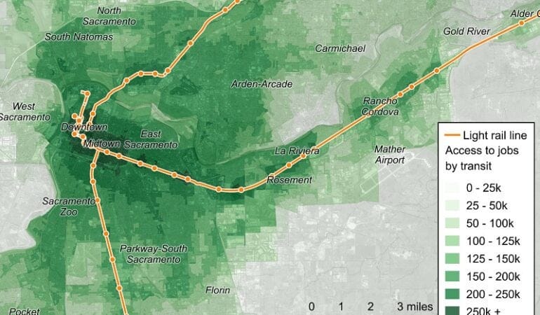
In California, a $12 million pilot program launched last fall by the City of Sacramento and Sacramento Regional Transit has expanded low-cost rides in electric shuttles to connect people in the lower-income neighborhoods of disinvested South Sacramento with jobs and services as part of a larger effort to provide greater social and economic equity around transit. The shuttles cost less than ride-hailing services, and rides are free for groups of five or more. So far the electric vehicles are not AVs, but in a city that prides itself on being, in the words of Mayor Darrell Steinberg, “a center of innovation in new transportation technologies,” that could soon change.


Kathleen McCormick, principal of Fountainhead Communications, LLC, lives and works in Boulder, Colorado, and writes frequently about sustainable, healthy, and resilient communities.

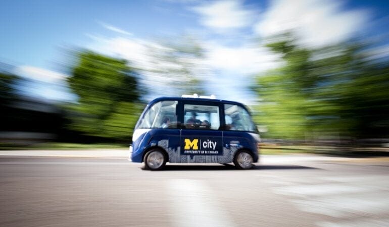
Photograph: A driverless shuttle at the University of Michigan in Ann Arbor, where researchers are studying consumer acceptance of autonomous vehicles. Credit: Levi Hutmacher, University of Michigan. 


References

Arity. 2018. “Be Patient, a Change Is Gonna Come.” November 8. https://www.arity.com/move/patient-change-gonna-come/.

Bloomberg Philanthropies and The Aspen Institute. 2017. “Taming the Autonomous Vehicle: A Primer for Cities.” Long Island City, NY: Bloomberg Philanthropies and The Aspen Institute (March). https://www.bbhub.io/dotorg/sites/2/2017/05/TamingtheAutonomousVehicleSpreadsPDF.pdf.

Bragg, Dave and Stephen Pazzano. 2017. “The Transportation Revolution: The Impact of Ride-Hailing and Driverless Vehicles on Real Estate.” Washington, D.C.: Urban Land Institute and Green Street Advisors (October). http://s3-us-west-2.amazonaws.com/gstqa-us-west/uploads/2017/10/19153037/ULI-Green-Street-Fall-17-Presentation.pdf.

City of Austin and Capital Metropolitan Transportation Authority Board. 2017. “Smart Mobility Roadmap.” Austin, TX: City of Austin and METRO (October). http://austintexas.gov/sites/default/files/files/Smart_Mobility_Roadmap_-_Final.pdf.

Crute, Jeremy, William Riggs, AICP, Timothy Chapin, and Lindsay Stevens, AICP. 2018. “Planning for Autonomous Mobility.” Chicago, IL: American Planning Association (September). https://www.planning.org/publications/report/9157605/.

Deloitte. 2019. “Global Automotive Consumer Study: Advanced Vehicle Technologies and Multimodal Transportation.” https://www2.deloitte.com/us/en/pages/manufacturing/articles/automotive-trends-millennials-consumer-study.html#.

Governing. 2017. “Special Report: How Autonomous Vehicles Could Constrain City Budgets.” Washington, D.C.: Governing (July). https://www.governing.com/gov-data/gov-how-autonomous-vehicles-could-effect-city-budgets.html#data.

Harvard University Graduate School of Design. “Future of Streets.” https://www.gsd.harvard.edu/project/future-of-streets/

Perkins, Lucy, Nicole Dupuis, and Brooks Rainwater. 2018. “Autonomous Vehicle Pilots Across America.” Washington, D.C.: National League of Cities. https://www.nlc.org/sites/default/files/2018-10/AV%20MAG%20Web.pdf.

Scharnhorst, Eric and Research Institute for Housing America. 2018. “Quantified Parking: Comprehensive Parking Inventories for Five U.S. Cities.” Washington, D.C.: Mortgage Bankers Association (May). https://www.mba.org/Documents/18806_Research_RIHA_Parking_Report%20(1).pdf.

SDOT (Seattle Department of Transportation). 2017. “New Mobility Playbook.” Seattle, WA. September. https://www.seattle.gov/Documents/Departments/SDOT/NewMobilityProgram/NewMobility_Playbook_9.2017.pdf.

Shared Mobility Principles for Livable Cities. https://www.sharedmobilityprinciples.org/.

University of Oregon. “Urbanism Next Center.” https://urbanismnext.uoregon.edu/

A sand-colored building with a domed roof stands on the left with trees on the right and a statue of a man on a horse in the foreground.

Public Finance

As Real Estate Booms, Can Texas Offer Property Tax Relief?
By Will Jason, Março 19, 2019


By now, the story is well known. The housing market booms, property taxes rise, and taxpayers demand relief.

In the story’s original version in the late 1970s, inflation in California’s home prices skyrocketed from 5 percent per year to 5 percent per month, setting off a tax revolt that culminated in Proposition 13, a strict set of property tax limits that inspired copycat laws across the United States.

Now, after years of rising home prices fueled by new jobs and migration, Texas faces similar pressure. From 2013 to 2017, property tax collections increased by about a third in major cities like Houston, San Antonio, Dallas, and Austin, and by much more in some neighborhoods.

“Texas is experiencing what California experienced in the 1970s,” said Debbie Cartwright, an attorney for the Texas Taxpayers and Research Association. “People who have owned their properties for a while are feeling the pinch.”

The situation in Texas is just the latest sign of the great property tax conundrum. Favored by many economists for being stable, efficient, and transparent, the property tax is also unpopular because it is so visible, and because it’s not tied directly to people’s ability to pay. Even now that the housing market is cooling, property tax bills are unlikely to decline much in the near future because assessors take a while to catch up to market values.

Texas policy makers are considering a host of measures designed to reduce property taxes, chief among them a proposal to limit the annual growth in local property taxes—the “levy”—to 2.5 percent. Anything greater would require voter approval.

Mayors of 24 of the largest Texas cities have called the proposal unworkable, citing the need to provide basic public services, absorb higher health insurance rates and other costs beyond their control, and invest in public health, safety, transportation, and economic development.

Texas, which already restricts property tax levy growth to 8 percent per year, is not the only state considering new or tighter levy limits. Policy makers have introduced similar proposals in New York, Iowa, and Nebraska, although Texas faces the additional challenge of being one of only seven states without an income tax.

The levy limit, used in about 35 states, is actually an improvement over the Proposition 13 model, which reduces property taxes in a fundamentally different way, by artificially keeping assessed values of long-owned properties far below market value. The result is that owners of identical homes can have vastly different property tax bills. As detailed in a Lincoln Institute report, assessment limits have had many bad side effects, including major inequities and perverse incentives that distort the real estate market.

Levy limits, by contrast, preserve market-rate assessments, but they share some of the other negative consequences of assessment limits—a reduction in local governments’ autonomy, and sometimes a greater reliance on state aid, which can be more volatile. In the end, no property tax limit can defy the basic math of government budgets, and the need for revenue to fund education, infrastructure, public safety, and other priorities.

“Public services cost money,” said Adam Langley, associate director of tax policy and data initiatives for the Lincoln Institute. “If taxpayers want lower property taxes, then governments either need to cut services or fund them through some type of tax—a tax limit does not eliminate this basic trade-off.”

Langley is studying other tools that preserve local governments’ taxing authority but still provide property tax relief to those who need it most. These include “circuit breakers,” which offer relief to lower income and elderly residents if their property tax bills reach a certain percentage of their income—in the same way a circuit breaker protects a home from excess electrical current—and deferrals, which defer collection of property taxes until a property is sold or the owner dies. A more widely used tool, the homestead exemption, spares a certain amount of home value from taxation.

Another option is for states to provide more aid to local governments or to take responsibility for more services. In Texas, lawmakers are exploring options to increase the state’s contribution to public schools, which has declined under a complex funding formula from 46 percent of all education funding in 2011 to 36 percent in 2018 (read more in the Lincoln Institute’s policy brief on school funding). And where possible, local governments should lower their property tax rates to compensate for higher property values.

“The property tax is a critical source of revenue for local governments,” Langley said. “When real estate prices rise, policy makers need to protect residents and businesses from unreasonable burdens while maintaining the integrity of the tax system overall. Research shows that with enough autonomy and the right tools, governments can do just that.”

Credit: TriciaDaniel/iStock/Getty Images

This image shows the Golden Gate Bridge in the foreground and the city of San Francisco lit up at night in the background.

Urban Planning

Lincoln Institute Experts to Offer Solutions at APA National Planning Conference
By Emma Zehner, Março 19, 2019


The Lincoln Institute of Land Policy will lead conversations on how to both plan and finance equitable and resilient communities at the American Planning Association’s National Planning Conference in San Francisco April 13 to 16, 2019. Over the course of 11 sessions, experts will share insights on scenario planning, water sustainability, land value capture, and public finance, among many other topics.

The Lincoln Institute will feature its growing work and expertise in scenario planning, a practice by which cities and regions can make better decisions about the future by incorporating more stakeholder input and other data. On Monday, All About Scenario Planning will introduce planners to the concept of scenario planning and equip them with the tools to design a scenario planning process. Other related sessions include Quantitative Scenario Planning in Practice and Scenario Planning for Transportation Unknowns.

Several sessions will focus on sustainability. On Sunday Jim Holway, director of the Lincoln Institute’s Babbitt Center for Land and Water Policy, will share lessons learned from his experience integrating water and land-use planning in the Colorado River Basin in Growing Water Smart: Integrated Resilience Planning. Another session, Smart Policies for a Changing Climate, will identify key planning strategies for designing resilient communities and highlight the intersection between community development and natural systems.

Other sessions will highlight how communities can pay for these and other planning initiatives. On Saturday, participants will play the Land Development Game, a simulation that helps users understand land and housing markets as well as the market impact of policies such as inclusionary housing. On Monday, Land Value Capture for Community Benefits, part of a conference track focused on inclusiveness and social justice, will tell the story of how Denver integrated land value capture in its area plan in order to produce affordable housing.

On Tuesday, Lincoln Institute President & CEO George McCarthy will lead Public Finance and Fiscal Sustainability, emphasizing the importance of public finance to the work of urban planners and exploring the challenges and benefits of different financing approaches for municipal government projects.

Lincoln Institute staff will be present at our booth in the exhibition hall throughout the conference. Free publications, including our quarterly magazine Land Lines, Policy Focus Reports, and Policy Briefs, will be available. We will also sell books and accept preorders for Design with Nature Now, a definitive new book inspired by Ian McHarg’s seminal text on ecological design in urban planning, first published 50 years ago.

A complete list of the Lincoln Institute’s sessions at the conference follows:


SATURDAY, APRIL 13

1:00 p.m. – 2:15 p.m. | Big City Planning Directors on Autonomous Vehicles

Andres Seutsuk, Cambridge, MA
David Dixon, Stantec’s Urban Places, Boston, MA
David Rouse, FAICP, American Planning Association, Washington, DC
Vincent Bertoni, City of Los Angeles, Los Angeles, CA
Anita Larement, NYC Department of Planning, New York, NY
Armando Carbonell, FAICP, Lincoln Institute of Land Policy, Cambridge, MA

Topics:

  • Understand key planning issues cities face from autonomous vehicles and related technological trends, including ecommerce and the sharing economy.
  • Understand how two of the nation’s largest cities are preparing for the arrival of autonomous vehicles.
  • Consider how to integrate autonomous vehicles with other transportation modes.

2:45 p.m. – 5:15 p.m. | Land Development Game

Amy Cotter, Lincoln Institute of Land Policy, Cambridge, MA
Daphne Kenyon, Lincoln Institute of Land Policy, Cambridge, MA
Carlos Morales-Schechinger, Universidad Nacional Autonoma de Mexico, Institute for Housing and Urban Development

Topics:

  • Understand how land and housing markets work.
  • Consider the market impact of development regulations.
  • Understand the impact of an inclusionary housing requirement

SUNDAY, APRIL 14

8:30 a.m. – 9:45 a.m. | Building the Civic Capacity Muscle

George McCarthy, Lincoln Institute of Land Policy, Cambridge, MA
Michael Ionna, AICP, City of Hamilton, Ohio, Hamilton, OH
John Collier, Greater Ohio Policy Center, Columbus, OH
Derek Santos, City of New Bedford, Massachusetts, New Bedford, MA

Topics:

  • Understand the concept of civic capacity and why it is important to a community.
  • Identify the changes they can make to increase their civic capacity to create change in their jurisdiction.
  • Be equipped to take the first steps toward implementing policies that foster civic capacity.

8:30 a.m. – 9:45 a.m. | Growing Water Smart: Integrated Resilience Planning

Andrew Spurgin, AICP, City of Westminster, Westminster, CO
Jeremy Stapleton, Sonoran Institute, Phoenix, AZ
Jim Holway, FACIP, Lincoln Institute of Land Policy, Phoenix, AZ

Topics:    

  • Describe and define a framework for integrating water and land-use planning in communities.
  • Describe the role of comprehensive plans in laying a foundation for integration of water and land planning.
  • Cite best policies, practices and resources for better ensuring communities and watersheds are resilient to uncertainty, such as the forces of population growth and climate change.

10:30 a.m. – 11:45 a.m. | Smart Policies for a Changing Climate

Ying-Yu Hung, SWA Los Angeles, Los Angeles, CA
Vaugh B. Rinner, Vaughn Rinner Landscape Architect, Seattle, WA
Nancy Somerville, American Society of Landscape Architects, Washington, DC
Armando Carbonell, FAICP, Lincoln Institute of Land Policy, Cambridge, MA

Topics:

  • Identify the most critical design and planning strategies for building healthy and resilient communities, along with policies and implementation strategies to put these resilient approaches into practice.
  • Understand the interconnection between natural systems and community planning and development, and see how policies can drive resilience and climate-smart adaptation to benefit humans and ecosystems. .
  • Explore the environmental justice concerns related to climate change and be able to identify the special needs of vulnerable communities.

MONDAY, APRIL 15

8:30 a.m. – 9:45 a.m. | All About Scenario Planning

Amy Cotter, Lincoln Institute of Land Policy, Cambridge, MA
Brett Fusco, Delaware Valley Regional Planning Commission, Philadelphia, PA
William Gilchrist, City of Oakland, Oakland, CA
Benjamin Zellers, AICP, City of Madison, Madison, WI

Topics:

  • Learn more about scenario planning and its uses.
  • Consider how scenario planning would fit into your planning processes.
  • Understand different scenario planning applications in different contexts.

8:30 a.m. – 9:45 a.m. | Directors’ Perspective on the Region

Albert C. Savay, City of San Carlos, CA
Dina Tasini, City Dixon, CA
Andrea J. Ouse, City of Concord, CA
Paul A. Jensen,City of San Rafael, CA
Hillary Gitelman, Environmental Science Associates, Oakland,
William A. Gilchrist, Oakland, CA
Peter Pollock, Planning from the Porch, Boulder, CO, Moderator
John S. Rahaim, City and County of San Francisco, CA
Rosalynn T. Hughey, City of San Jose, CA

Topics:

  • Understand more about the significant planning issues and opportunities in and around San Francisco from city planning directors in the region.
  • Learn about the planning techniques and innovations being employed to tackle some of the toughest planning challenges in the region, like gentrification, affordable housing, homelessness, transportation, aging infrastructure, and placemaking that could be applicable in their own communities.
  • Learn about ways in which individual communities are, or could, cooperate more at the regional level to solve planning problems.

1:00 p.m. – 2:15 p.m. | Land Value Capture for Community Benefits

Armando Carbonell, FAICP, Lincoln Institute of Land Policy, Cambridge, MA
Xinrui Shi, Lincoln Institute of Land Policy, Cambridge, MA
Abram Barge, AICP, City of Denver, Denver, CO

Topics:

  • Understand the strategies for land value capture and their legal status.
  • Anticipate the practical aspects of adding these strategies to your planning program.
  • Learn from a case study in which land value capture is integrated into the implementation of an area plan in Denver to generate affordable housing.

1:00 p.m. – 2:15 p.m. | Quantitative Scenario Planning in Practice

Elizabeth Schuh, Chicago Metropolitan Agency for Planning, Chicago, IL
Janae Futrell, AICP, Civic Sphere, Atlanta, GA
Timothy Reardon, Metropolitan Area Planning Council, Boston, MA

Topics:

  • Understand the basics of quantitative scenario planning.
  • Process how two regional agencies have applied quantitative scenario planning.
  • Identify planning challenges for which quantitative scenario planning is helpful.

2:45 p.m. – 4:00 p.m. | Managing Risk of Sea Level Rise

Jens Thalheim, FM Global, Norwood, MA
Amy Cotter, Lincoln Institute of Land Policy, Cambridge, MA
Gina Bartlett, Consensus Building Institute, Cambridge, MA
Kristina Dahl, San Francisco, CA

Topics: 

  • Review specific and comprehensive risks to property, municipal revenue, and economies from sea level rise.
  • Learn about data, models, and information to help manage the risk of sea level rise.
  • Learn ways to make the case for climate change adaptation actions as a component of risk management.

4:15 p.m. – 5:30 p.m. | Scenario Planning for Managing Transportation Unknowns

Jeremy Raw, Federal Highway Administration, Washington, DC
Brett Fusco, Delaware Valley Regional Planning Commission, Philadelphia, PA
Janae Futrell, AICP, Civic Sphere, Atlanta, GA

Topics:

  • Understand the role of scenario planning in supporting confident transportation planning decisions.
  • Apply scenario planning to better prepare for the opportunities, challenges, and uncertainty that may arise with automated vehicles and other transportation innovations.
  • Identify other transportation planning challenges to which a scenario planning approach may apply.

TUESDAY, APRIL 16

10:15 a.m. – 11:30 a.m. | Public Finance and Fiscal Sustainability

Armando Carbonell, FAICP, Lincoln Institute of Land Policy, Cambridge, MA
George McCarthy, Lincoln Institute of Land Policy, Cambridge, MA
Michael Belsky, Center for Municipal Finance at the University of Chicago Harris School of Public Policy, Chicago, IL

Topics:   

  • Identify and understand prevailing methods for financing municipal government projects such as housing and infrastructure.
  • Understand the challenges and benefits of different financing approaches to make better-informed planning decisions.
  • Gain an understanding of the importance of public finance to the work of urban planners.


The Lincoln Institute has been a longstanding partner with the American Planning Association’s National Planning Conference, which is in its 111th year.


Photograph: Getty Images Plus/Ultima_Gaina

This map shows transit patterns in the Sacramento area.

City Tech

The Road to Smarter Transit Is Paved with Data
By Rob Walker, Março 15, 2019


“What gets measured, gets managed,” goes the business truism. The idea applies to the design of cities and infrastructure, too. And the emergence of big data—massive sets of raw information made possible by new collection and storage technologies—is making possible new measurements that can inform how state transportation agencies plan and manage their projects.

Consider the work being done by the State Smart Transportation Initiative. Founded in 2010 at the University of Wisconsin, SSTI uses new data troves to guide real-world land use and planning decisions. By combining and analyzing data on questions ranging from how people access transit stations to how easy it is for them to get to work or the grocery store, SSTI is shedding light on patterns that can inform future decision making.

In 2018, SSTI began operating in partnership with the nonprofit Smart Growth America (SGA), whose programs include serving as a resource for state departments of transportation. SGA had collaborated with SSTI on multiple editions of The Innovative DOT: A Handbook of Policy and Practice, a guide for “for DOTs committed to innovative excellence.” The partnership now works with more than a dozen transportation agencies, functioning as a kind of policy knowledge base and providing direct technical assistance.

One key to making the most of big data is finding the right framing. “Accessibility means looking at ‘how accessible is this place?’ as opposed to ‘how fast are the cars going on a certain part of road?,’” explains SSTI Director Eric Sundquist. This more holistic approach is not a new idea, but it’s one that’s gaining momentum, partly because of richer data and more sophisticated tools for sorting it. In recent research, SSTI defined accessibility as “the ease with which people may reach opportunities such as jobs, stores, parks, schools, and other destinations. ‘Ease’ is measured in terms of travel time, with some adjustments to account for how travelers use the system.”

Among other projects, SSTI has been working with the Virginia Department of Transportation, whose Smart Scale program draws on a range of big data to “score” transportation proposals submitted by counties and municipalities on their likely ability to improve accessibility to jobs. The most recent round also incorporates access to non-work destinations such as shopping and parks.

As an example, an SSTI planning exercise focused on improving non-work-destination access in Vienna, Virginia. One track of analysis explored how beefing up a walking network and bike path could better connect the town’s main street to other neighborhoods. But another track considered a scenario that involved a shift in land use: encouraging the commercial development of an underused area on the southern edge of town. The latter actually led to higher-scoring accessibility improvements than the hypothetical transportation projects.

This scoring scheme draws on population, employment, and land use data; auto data; transit service data that’s now largely reported in a consistent format thanks to Google Maps; and bike and pedestrian data. Depending on the project, more data can be added, like job categories and neighborhood income. This opens up broader thinking about how “accessibility” can be improved, measuring whether the best option is building new pedestrian infrastructure or working to place a grocery store in a food desert.

“We’ve made people aware of this in our community of practice,” Sundquist adds, so that other DOTs can build on the same ideas. And indeed, transportation officials from Hawaii recently worked with SSTI to try to take the scoring process “a step further,” he continues. “We scored all their projects on a weighted accessibility basis. So if a project provides more access by transit in relation to auto, it will suggest how modes might shift.” The state is evaluating SSTI’s results now.

Such data represent both improvements on existing information-gathering methods and measurements that are altogether new, observes Amy Cotter, associate director of Urban Programs at the Lincoln Institute.

For example, she says, planning decisions have often relied heavily on transit survey results, which are “expensive to collect and sometimes questionable.” So the emergent technologies SSTI is harnessing—including “trip-making data” culled from services that aggregate information from GPS-enabled vehicles, navigation devices, and even smartphone apps—are an enticing alternative. “These new data are providing better information at lower cost to prepare agencies, planners, and state DOTs to make better decisions,” Cotter says.

The Lincoln Institute partnered with SSTI in a 2017 project, “Connecting Sacramento,” along with a variety of public and private entities and stakeholders. The resulting study, which catalyzed much of SSTI’s more recent work, sought to assess how these new data sources, and new tools for understanding data, could help improve transportation policy.

The Sacramento research included a case study on walking trips to and from a particular transit station. SSTI worked with traffic analytics startup StreetLight Data, which has devised methods for assessing GPS signals with machine learning to distinguish walking and biking behaviors. Walking and biking have at times “gotten short shrift” in planning efforts, says Sundquist, precisely “because they’re so hard to measure.” So adding this new information to other transportation and land use data sets can lead to new discoveries. In this case, the data pointed out an unexpectedly high percentage of foot trips between the transit station and a particular cluster of office buildings. This was surprising, given that the buildings not only had ample parking, but also were accessible on foot only by way of a single route—across a freeway. The study argued that, in light of this finding, improved or additional access points would improve conditions for current commuters and encourage more to join in.

Such analysis, of course, can often be miles ahead of the realities facing a state department of transportation. But programs like Virginia’s Smart Scale rating system suggest what big data analysis might lead to. Continuing advances in data collection and analysis should mean we will be better able to evaluate the impact of any given project, and better able to compare that to what was predicted—and adjust for the future.

The “what gets measured gets managed” cliché is sometimes used, inappropriately, to argue that what isn’t (or can’t be) measured also can’t—or even needn’t—be managed. But as Sundquist argues, these new forms of transportation data and analysis can be considered as an opportunity. They can reveal practical, actionable information. And they can also help planners, transportation managers, and others think creatively about what they wish they could measure next.


Rob Walker is a journalist covering design, technology, and other subjects. His book The Art of Noticing will be published in May 2019. 

Image: Mapping and data analysis by the State Smart Transportation Initiative can help transportation officials make more informed decisions. This map shows transit patterns in the Sacramento area. Credit: State Smart Transportation Initiative


Gleam Davis

Mayor’s Desk

Santa Monica Goes All-In on Green: Reflections from Mayor Gleam Davis
By Anthony Flint, Março 5, 2019


For some people, Santa Monica conjures images of sunshine and surfing. But the southern California city should rightly be known for sustainability, too. The City Council adopted the Santa Monica Sustainable City Program in 1994; twenty-five years later, the city has made measurable progress on projects ranging from retrofitting buildings to embracing renewable energy. The council selects a new mayor every one to two years, ensuring fresh perspectives at the helm. Most recently, Gleam Davis was sworn in as mayor in December 2018, after serving on the City Council since 2009. Active in the community since moving there in 1986, she has been involved with the Santa Monica Planning Commission, Santa Monicans for Renters’ Rights, the Board of Directors of WISE Senior Services, and the Santa Monica Child Care and Early Education Task Force, among many other organizations. As corporate counsel for AT&T, she has worked with KIND (Kids in Need of Defense), which represents unaccompanied minors in immigration courts. Before joining AT&T, Davis prosecuted civil rights violations as a trial attorney in the Civil Rights Division of the U.S. Department of Justice, and was a partner at the law firm of Mitchell, Silberberg & Knupp. A native of California, she holds degrees from Harvard Law School and USC. Davis and her husband, John Prindle, have one son, Jackson. She spoke with Lincoln Institute Senior Fellow Anthony Flint about Santa Monica’s sustainability efforts, which have been heralded by OECD’s Champion Mayors, for this issue of Land Lines. 

Anthony Flint: Does Santa Monica’s system of having a mayor for two years present a challenge for sustainability efforts, which often are slow to get going—and to pay off? What are the projects that can have the greatest impact through your upcoming term?

Gleam Davis: I don’t think it creates much of an impediment to the sustainability agenda. The mayor and the mayor pro tem are members of the entire city council. The city council sets the policy, adopts the budget, and drives the city’s policies. Then it’s the city manager who does the implementation. Whatever policy direction is given to the city manager is from a vote of the full city council.

On the sustainability front, the big news is we are now part of a group called the Clean Power Alliance, where the default provision for customers is power that is 100 percent sourced from renewables. This is helping us take a big leap toward energy self-sufficiency. People can choose to shift into lower tiers, such as 50 percent renewable, or they can opt out entirely. There are also discount options for low-income families. So far the opt-out rate is very low.

Another continuing thread is providing mobility choices. We live in a compact city, less than nine square miles, and we have the ability to provide transport options to our residents. We have light rail with three stations, so you can take transit to downtown Santa Monica or downtown LA. For our Big Blue Bus, [which runs on natural gas and is moving toward an all-electric fleet by 2030], we have a policy of ‘any ride, any time,’ so students can get on a bus, show an ID card from any college—a lot of UCLA students ride those lines, and of course [students from] Santa Monica College—and it’s free.

AF: The city’s overall greening strategy has included a first-of-its-kind zero net energy ordinance for new single-family construction and a commitment that all municipal power needs be met by renewables. But the new $75 million municipal building project has been criticized as too expensive. How can being green be cost-effective?

GD: What’s important to know is, we’re leasing a fair amount of private property for government offices, at a cost of roughly $10 million a year. We needed to bring employees into a central location, which will save money on leases, and will encourage face-to-face and ‘accidental’ meetings that can be so important to communication. It just made business sense to have everybody under one roof. We’ll end up saving money over time, and ultimately the building will pay for itself just on that basis. There will be additional savings over time if the building is energy neutral and has reduced water intake—we won’t be consuming resources outside the building.

One of the things we’ve done is require developers to meet pretty stringent sustainability requirements. If we’re going to do that, we need to walk the walk. That’s one of the things this building shows—it’s possible to build an aggressively sustainable building that will ultimately bring savings. We’re trying to be a model, to show that with a little up-front investment, you can have a big impact over time.

AF: How does the Wellbeing Project, which won an award from Bloomberg Philanthropies for its ongoing assessment of constituents’ needs, connect to your sustainability efforts? What has it revealed?

GD: We declared ourselves a sustainable city of well-being. How are the people in the community faring—are they thriving, or are there issues? The Wellbeing Project began as an assessment of youth and how they were doing, and what can we as a city do, to try to help. It’s really about changing the relationship between local government and people. It’s not really a new concept—it goes back, not to be corny, to the Declaration of Independence: life, liberty, and the pursuit of happiness. That doesn’t mean people going out and having a good time, but the ability of people to thrive. A sense of community can get frayed, whether due to technology or culture. One of the things we do is make sure children enter kindergarten ready to learn. For our older citizens, are they feeling isolated in their apartments? It’s a global movement we’re thrilled to be a part of.

In our Wellbeing Microgrant program, if people come up with something to build community, we will fund it, up to $500. One example was going out and writing down the histories and memories of Spanish-speaking residents in the many parts of the community where English is a second language. Another was a dinner to bring together our Ethiopian and Latino communities. One individual took a vacant lot and created a pop-up play area and space for art. It’s about community connectedness.

AF: Another innovative strategy is to impose charges on excess water use to fund energy-efficiency programs in low-income homes. In terms of water, what’s your long-term view on managing that resource in what looks to be perilous times ahead?

GD: The other thing we’ve done, which will percolate throughout my term and next, is to work on becoming water self-sufficient. We control a number of wells in the region, but we had contamination in the 1990s, and ultimately reached a multi-million-dollar settlement [with the oil companies responsible]. We had been getting 80 percent of our water from the Metropolitan Water District [after the contamination was discovered]—if you saw Chinatown, that’s [the system that] sucks water out of the Colorado River and brings it to LA—and now we’ve totally flipped that, and we’re getting 80 percent of our water from our own (restored) wells again. This makes us more resilient in case of an earthquake affecting the aqueducts or other disruptive events to water infrastructure, like broken water mains. Pumping water over mountains [from the Colorado River] also takes a lot of energy. We are making sure our water infrastructure is sound. We’re not trying to isolate ourselves. But by getting water from our own wells, we will have good clean water for the foreseeable future.

AF: What policies would you like to see that might limit the devastation so sadly seen in the recent wildfires in California?

GD: Luckily Santa Monica was not directly affected by the Woolsey Fire. Our neighbor Malibu was—their emergency operations center was right in the path of the fire, so they came and used ours, for fighting the fire, rescuing people, and cleaning up. We had Santa Monica firefighters on the ground throughout the state under mutual aid. We hosted meetings with FEMA on displacement and recovery. We have a chief resiliency officer, and she is a steady drumbeat, reminding people [that a major natural disaster] could happen here. We have promoted the Seven Days Plan—does everyone have seven days of water, food, and an emergency radio that doesn’t require electricity? We also passed aggressive earthquake requirements, evaluated properties that are most vulnerable, and are now moving to seismically retrofit them.

These things we do in Santa Monica may seem a little aggressive, and cost money, but it’s not just about winning awards or patting ourselves on the back for being environmentally progressive, it’s so that we’ll be able to weather things like fires. People say you’re spending money, raising water rates, and it costs more for energy. . . . We want to do it to address the impacts of climate change. But it also means that when there’s a natural disaster, we are more resilient.

AF: The city’s experience with electric scooters—I’m referring to the company that deployed a fleet without asking permission—seemed to show that the transition to a sharing economy coupled with technological innovation can be messy. Is it possible to welcome disruption and maintain order?

GD: We were sort of ground zero for scooters. It was disruptive at first, and we had to make a lot of adjustments. Their philosophy was that it was easier to ask forgiveness than permission. There was some panic, and some people were also using them in a horrible manner. Now we’re in a 16-month pilot program, where we selected four dockless mobility operators: Bird, Lime, Jump, which is part of Uber, and Lyft. We created a dynamic cap on the number of devices on the street, so they can’t put out as many as they want. We have some policies to address conflicts and safety, and we have issued tickets when necessary.

This is all part of giving our residents lots of mobility options. It’s all designed to give people the option to get out of their car, whether it’s going to downtown LA or walking two blocks to a neighborhood restaurant. We wanted to make sure our more economically diverse communities had access, so it’s not just downtown. If you can replace a car with alternative means that include scooters or electric bikes for that first or last mile, that’s a big cost savings. We had about 150,000 rides on shared mobility [in November 2018]. That’s pretty amazing for a place with 93,000 people. At the end of the pilot, we’ll evaluate everything and figure out where we go from there.

A number of neighboring cities banned scooters outright, but that’s not how Santa Monica deals with technology. We’re figuring out the best way to manage the disruptive technology. Disruption isn’t a four-letter word.

Photograph: Kristina Sado

2019 Economic Perspectives on State and Local Taxes

Maio 6, 2019 | 8:30 a.m. - 3:30 p.m.

Cambridge, MA United States

Free, offered in inglês

This small interactive seminar allows legislators and legislative staff to consider state and local taxes and other fiscal issues from an economic perspective. Legislators and/or legislative staff from each New England state will participate. The program is co-sponsored with the Federal Reserve Bank of Boston.


Details

Date
Maio 6, 2019
Time
8:30 a.m. - 3:30 p.m.
Registration Period
Março 12, 2019 - Abril 1, 2019
Location
Lincoln Institute of Land Policy
113 Brattle Street
Cambridge, MA United States
Language
inglês
Registration Fee
Free
Cost
Free

Keywords

Desenvolvimento Econômico, Economia, Governo Local, Tributação Imobiliária, Finanças Públicas, Tributação, Valoração, Recuperação de Mais-Valias