Should We Allow More Homes to Be Built in Existing Neighborhoods?
By Amy Dain, Novembro 28, 2022
SHARE
Where should new multifamily housing go? This is a fundamental question facing 175 communities across eastern Massachusetts as they work to implement a new law intended to address the region’s housing shortage. The law requires cities and towns served by Greater Boston’s public transit agency, the MBTA (Massachusetts Bay Transportation Authority), to enact zoning that allows multifamily housing near transit.
If history is any indication, communities will seek to locate new housing away from existing residential neighborhoods. In recent decades, the largest portion of new housing in Greater Boston has been built in isolated areas on municipal and metropolitan peripheries. As an example, the town of Wellesley approved the construction of a 262-unit complex called The Nines—separated from almost all of the town by Interstate 95 and located on a spit of land tucked between the highway, state Route 9, and the Charles River. The towns of Needham and Stoneham permitted similar “across the interstate” developments, and other examples abound.
The next largest portion of residential permitting has come in commercial areas. As “smart growth” caught on in the new millennium, many cities and towns added one or two small- or medium-sized multifamily buildings to their downtowns. These properties are very close to residential neighborhoods, but not right in them. Zoning for mixed-use developments along decaying strip mall corridors has also been gaining support. Thus, we see projects on Newton’s Needham Street, Bedford’s Great Road, Salem’s Highland Avenue, Swampscott’s Vinnin Square, and many other less-than-loved “stroads.”
For many communities, preserving the status quo of existing neighborhoods has been an explicit priority, even as the housing crunch has intensified. A few years ago, the city of Weymouth rezoned a commercial corridor for mixed-use multifamily housing, drawing the zoning district surgically to avoid development near existing residential neighborhoods. Wellesley’s 2018 Draft Unified Plan explains that participants in public meetings saw commercial, office, and industrial areas as the most acceptable locations for multifamily housing; not residential districts. In fact, my review of local master plans across 100 cities and towns showed no movement to upzone residential neighborhoods, other than by allowing accessory dwelling units (ADUs), which appear to have relatively popular support.
Given the political resistance to changing residential neighborhoods, developing housing in other areas is not without merit. The Metropolitan Area Planning Council, the regional planning agency, recently analyzed more than 3,000 strip malls and shopping centers across Greater Boston, and estimated that such sites could accommodate 124,000 new homes. Between those areas and various office parks and industrial lands, Greater Boston could raise enough residential towers and townhouses to end bidding wars, giving renters and buyers the upper hand, without changing existing residential neighborhoods.
However, the strategy of rezoning exclusively commercial and industrial areas assumes that the only goal is housing production. Metropolitan growth policy also needs to consider transportation, the environment, local economies, quality of life, and equity.
The transit-oriented development (TOD) paradigm at the heart of Massachusetts’s new MBTA Communities Zoning Law imagines a region defined by a network of walkable, dense hubs that are well-connected by roads, walkways, bike lanes, bus lanes, train lines, and ferry routes. Under this scenario, people will spend less time in traffic; convenient region-wide mobility will be accessible to all residents, including those without cars; carbon emissions will go down; more people will have access to the region’s best opportunities; and our collective well-being and resilience will improve.
One of Greater Boston’s most prominent strengths is that it was built as a network of urban villages well connected by trains and streetcars before automobiles began dominating urban design. The framework for the vision of well-connected “great neighborhoods” is already on the ground. The metropolitan area is crisscrossed with village centers and downtowns that contain pharmacies, libraries, restaurants, cafes, civic institutions, schools, playgrounds, public greens, quirky shops, and transit stops.
If we write off as unchangeable all residential neighborhoods adjacent to these great hubs, then we make it harder to achieve the combined goals of an abundance of housing and sustainable, equitable settlement patterns. There is great demand in Greater Boston for “missing middle” housing that fits between single family-houses-with-yards and bigger apartment/condo complexes. For development of smaller scale multifamily housing to serve many people and make a difference in the market, it has to be allowed in more places.
A residential neighborhood in Waltham, Massachusetts. Credit: Amy Dain.
The project to create more housing in the Boston area will involve a combination of strategies, including significantly more building on main streets and the currently car-oriented corridors that radiate out from them; continued building on some isolated parcels on municipal edges; and incremental increases in density near connected, walkable hubs—i.e., in existing residential neighborhoods. Significant development on isolated parcels and strip mall corridors should be accompanied by infrastructure redesign to create connected, walkable hubs.
As they consider different development scenarios that meet the requirements of the MBTA Communities zoning law, leaders and residents will need to weigh the politics and pros and cons of dense zoning in commercial and industrial areas, against zoning for small-scale multifamily housing in neighborhoods. Their deliberations will be part of a larger national debate about how regions should grow.
Many people will be anxious about the possibility of multifamily development next to their homes. They’ll worry about traffic and parking, property values, architecture, noise, privacy, and all sorts of things. But we could just as well associate new housing with the chocolate chip cookies the future residents might bake for block parties, the leadership they might take on local issues, and the purple pansies they might plant out front in big happy planters. We could think of the joy, stability, and safety that new neighbors will gain in, and contribute to, our neighborhoods.
Humans are perhaps wired to protect against threats more than to revel in visions of possibility, but we are also well equipped to plan ahead, together. We should plan for a just and sustainable future with abundant housing in wonderful, connected neighborhoods—and reform local zoning accordingly.
Amy Dain is an independent consultant in public policy research and writing. Her focus is on urban and suburban planning and housing policy. She has conducted research for the Lincoln Institute on zoning and approval processes for multifamily housing in the Greater Boston area.
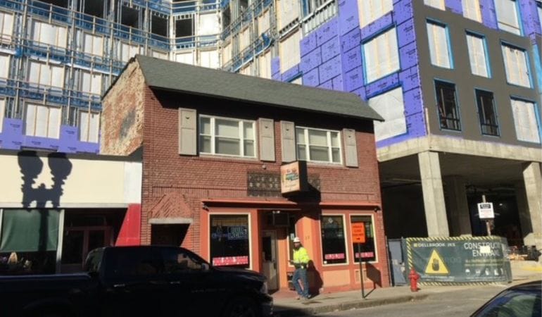
Image: Construction in downtown Lynn, Massachusetts. Credit: Amy Dain.
Oportunidades de bolsas para estudantes graduados
2023 C. Lowell Harriss Dissertation Fellowship Program
The Lincoln Institute's C. Lowell Harriss Dissertation Fellowship Program assists PhD students whose research complements the Institute's interest in property valuation and taxation. The program provides an important link between the Institute's educational mission and its research objectives by supporting scholars early in their careers.
The application deadline is 6:00 p.m. EST on March 3, 2023.
A medida que la crisis climática obliga a los habitantes de los EE.UU. a reubicarse, surge una nueva conversación
Por Alexandra Tempus, Julho 14, 2022
SHARE
A pesar de que la espera, Frances Acuña filtra mi llamada. “Me llaman muchas personas que quieren comprar mi casa”, explica cuando me devuelve la llamada. “A veces recibo cinco cartas por correo y hasta 10 llamadas”.
El barrio Dove Springs en el sureste de Austin, Texas, donde Acuña lleva 25 años viviendo, se encuentra a 15 minutos del centro y en el límite de la última ola de aburguesamiento. Hace una década, dice, aquellos que no eran locales no querían involucrarse con la comunidad trabajadora de las casas de campo modestas: “Para ellos era una especie de gueto”.
En 2013, el arroyo Onion Creek desbordó, tras recibir casi 255 milímetros de lluvia en un solo día, e inundó las calles. Murieron cinco habitantes y se inundaron más de 500 viviendas. Dos años más tarde, se produjo otra inundación histórica. La ciudad de Austin, que ya había comenzado a comprar y demoler las viviendas de esta área baja con la ayuda de préstamos federales, aceleró sus esfuerzos y logró adquirir y demoler más de 800 casas.
Las propiedades adquiridas mediante programas de compra de viviendas financiados por la Agencia Federal para el Manejo de Emergencias (FEMA, por su sigla en inglés) deben permanecer “abiertas a perpetuidad”, para permitir que se inunden de manera segura en el futuro. En este caso, la ciudad transformó cientos de hectáreas de suelo abandonadas cerca de Dove Springs en un parque. Ahora, la zona cuenta con instalaciones atractivas: un área de recreación, un parque para perros, senderos y áreas con sombra para relajarse. Estas mejoras urbanas, impulsadas explícitamente por políticas de adaptación climáticas, hicieron que el área sea incluso más atractiva para los nuevos habitantes recién llegados (con un promedio de 180 recién llegados por día en 2020, Austin se encuentra entre las áreas metropolitanas de crecimiento más rápido del país).
Sin embargo, para Acuña el parque es un recordatorio doloroso de los vecinos que sufrieron pérdidas y de que incluso los esfuerzos bienintencionados de poner a salvo a las personas pueden causar daño. “Para mí no es un lugar alegre”, dice Acuña. “Quizás [los recién llegados] no lo saben porque solo ven un espacio verde”.
A medida que aumenta la magnitud de las inundaciones, los incendios, los huracanes y otras catástrofes naturales por el cambio climático, los expertos del Consejo para la Defensa de Recursos Naturales (NRDC, por su sigla en inglés) de la Oficina de Responsabilidad Gubernamental de los EE.UU. recomiendan enfáticamente que las municipalidades retiren las viviendas y la infraestructura de las zonas propensas a riesgos, a fin de ahorrar dinero y salvar vidas. Pero ¿cómo puede producirse la reubicación por el clima de forma que evite el aburguesamiento y el desplazamiento, honre la cultura y la historia de los habitantes originales, fomente el cambio de la planificación reactiva a la proactiva y garantice que aquellos que deben reubicarse puedan encontrar lugares seguros y asequibles para vivir?
Estas son las preguntas que Acuña y una creciente red de dirigentes, planificadores, investigadores, funcionarios de agencias y gestores de políticas locales buscan responder como parte de Climigration Network.
Fundada en 2016 por el Consensus Building Institute, Climigration Network busca posicionarse como la fuente central de información y apoyo para las comunidades de los EE.UU. que deben reubicarse o que lo están considerando debido a los riesgos climáticos. Más del 40 por ciento de los habitantes de los EE.UU., alrededor de 132 millones de personas, viven en un condado que padeció alguna condición climática extrema en 2021 (Kaplan y Tran, 2022). El crecimiento poblacional en las áreas propensas a incendios forestales se duplicó entre 1990 y 2010, y continúa creciendo. La FEMA dice que hay 13 millones de estadounidenses viviendo en zonas inundables para un período de retorno de 100 años (uno por ciento de probabilidad anual), mientras que al menos un estudio destacado indica que son 41 millones (Wing et al., 2018).
Las Naciones Unidas, el Banco Mundial y los académicos admiten que la mayoría de las migraciones climáticas se producen dentro de los límites nacionales, no hacia afuera. Pero en los Estados Unidos, la conversación sobre los sistemas necesarios para apoyar la migración climática fluye lentamente, incluso a pesar de que el cambio climático redobla su impacto en las riberas, las costas y otras regiones vulnerables. Un informe publicado el año pasado por la Casa Blanca sobre el tema marcó, según su propio cálculo, “la primera vez que el gobierno de los EE.UU. informa oficialmente la relación entre el cambio climático y la migración” (Casa Blanca 2021).
En la actualidad, la mayoría de las reubicaciones relacionadas con el clima en los Estados Unidos se producen del mismo modo que sucedió en Dove Springs. Luego de una catástrofe natural, se envía dinero federal para la recuperación, por lo general mediante la FEMA o el Departamento de Vivienda y Desarrollo Urbano de los Estados Unidos, a los estados y las municipalidades para comprar las viviendas dañadas. Los propietarios particulares le venden sus viviendas al gobierno al valor del mercado previo a la catástrofe natural y se mudan a otro sitio. Según el NRDC, la FEMA financió más de 40.000 compras en 49 estados desde la década de 1980.
Sin embargo, a pesar de los programas federales de compra establecidos hace décadas, no existe un conjunto de buenas prácticas o estándares oficiales. El tiempo promedio de compra es de cinco años. Mientras tanto, los costos de los arreglos y las viviendas temporales se acumulan. La orientación para los propietarios sobre cómo transitar el proceso de compra es confusa o casi inexistente, y las políticas y el financiamiento de la reubicación se centran en los casos particulares, no en los barrios o las comunidades que quieren permanecer juntas.
A nivel local, las comunidades que evalúan la reubicación se enfrentan a varias barreras sociales y financieras. Las municipalidades no suelen fomentar la reubicación porque no quieren perder a la población ni la renta de los impuestos. Los habitantes, en especial aquellos que se enfrentan a una crisis, no suelen tener la capacidad y los recursos para encontrar un nuevo lugar seguro donde vivir, incluso aunque estén dispuestos a trasladarse.
A pesar de esos obstáculos, algunos pueblos pequeños diseñaron barrios nuevos e incluso pueblos nuevos a los que trasladarse. En la década de 1970, un par de pueblos del centro de los EE.UU. (Niobrara, Nebraska y Soldiers Grove, Wisonsin) iniciaron algunos de los primeros proyectos de reubicación de comunidades. En la década de 1990, Pattonsburg, Missouri y Valmeyer, Illinois, entre otros, se reubicaron a tierras más altas tras la Gran Inundación de 1993 sobre el río Misisipi. A medida que aumenta el impacto climático, los pueblos y los barrios, desde Carolina del Norte y del Sur hasta Alaska, desarrollan planes similares. Sin embargo, es poco frecuente que se compartan los conocimientos o que haya una coordinación que podría ayudar a las comunidades a ajustar o incluso rediseñar el proceso.
Climigration Network, en conjunto con el Instituto Lincoln y otros, conecta las comunidades afectadas por el clima entre sí y con profesionales que pueden ayudar. Una de las preocupaciones iniciales era cómo presentar el concepto de “retirada controlada” como opción de adaptación para las comunidades que se enfrentan a un riesgo importante. El término, pensado para referirse a movimientos estratégicos hacia fuera de las áreas propensas a catástrofes naturales, se volvió común en los debates sobre políticas que se produjeron tras huracanes y grandes inundaciones en la década pasada. ¿La ciudad de Nueva York debería analizar una retirada controlada de su costa, en lugar de invertir en paredes costosas y posiblemente ineficaces, tras el huracán Sandy? ¿Debería hacerlo Houston tras el huracán Harvey? Los gestores de políticas, los planificadores y los investigadores debatieron estas preguntas en profundidad, muchas veces sin la participación de las comunidades afectadas, que consideraron el término y el concepto alienantes.
Cuando Climigration Network comenzó su trabajo, en seguida quedó en evidencia que se necesitaba un tipo diferente de conversación, dice la directora Kristin Marcell. Con financiamiento de la fundación Doris Duke Charitable Foundation, la red creó un equipo creativo liderado por personas de color y originarios de pueblos indígenas; los miembros del equipo provienen de comunidades afectadas por la crisis climática. El equipo, dirigido por Scott Shigeoka y Mychal Estrada, propuso rediseñar el debate sobre el problema actual que enfrentan los pueblos y los barrios que deberían reubicarse.
Los dirigentes del proyecto invitaron a más de 40 dirigentes de primera línea para que compartan sus experiencias tras una catástrofe natural, y la red los compensó por ese trabajo. El resultado fue un conjunto de datos sobre el mundo real que ahora están recopilados en una guía sobre la reubicación climática.
Una conclusión clara es que, cuando se trata de la “retirada controlada”, hay más cuestiones involucradas que solo la mala publicidad. Los dirigentes de las comunidades les explicaron a los investigadores que la palabra “controlada” resuena a paternalismo y programas gubernamentales jerárquicos. En las comunidades de color, trae recuerdos no muy lejanos del desplazamiento forzoso: el comercio de esclavos, el Sendero de las Lágrimas, los campos de reclusión y prácticas discriminatorias. El concepto de “retirada” dejó muchas preguntas sin responder.
“Crea una idea negativa de que las personas están huyendo de algo, en lugar de trabajar para lograr un objetivo”, escribieron los investigadores en la guía. “La palabra comunica qué se debería hacer, pero no adónde ir o cómo hacerlo” (Climigration Network 2021).
Ahora, Climigration Network aprovecha esa información en conversaciones con tres organizaciones comunitarias en el medio oeste, la costa del golfo de los EE.UU. y el Caribe que apoyan a los habitantes locales que analizan estrategias de adaptación, incluida la reubicación. Entre los socios que participan en estas conversaciones, se encuentran Anthropocene Alliance, una coalición de sobrevivientes de inundaciones y otras catástrofe naturales en los Estados Unidos, y Buy-In Community Planning, una organización sin fines de lucro que busca mejorar los procesos de compra de viviendas.
Los miembros de Climigration Network comenzaron a usar alternativas más inspiradoras a “retirada controlada”, incluidas “reubicación organizada por la comunidad” y “reubicación con apoyo”. Pero el objetivo no es encontrar un solo término nuevo o crear un plan estructurado que pueda adoptarse de forma universal. Como dice Marcell, puede ser “muy ofensivo” cuando personas externas se acercan a las comunidades con solo modelos y plantillas.
“No podemos ganarnos la confianza de una comunidad si no se empieza con una conversación abierta sobre cómo abordar el problema, porque [cada] contexto es único”, dice.
En cambio, la red busca cocrear con cada una de las organizaciones un método para identificar las necesidades y los objetivos específicos de cada lugar. Eso implica identificar y entrevistar a personas influyentes de la comunidad y, con la ayuda de Buy-In Community Planning, desarrollar preguntas para una encuesta puerta a puerta.
“Hay todavía mucho trabajo por hacer en la interacción y orientación individual con las personas que están en las peores situaciones del cambio climático”, dice Osamu Kumasaka de Buy-In Community Planning. Llegó a esta conclusión mientras trabajaba como mediador en el Consensus Building Institute en Piermont, Nueva York, en 2017. El pueblo ubicado sobre el río Hudson sufría el comienzo de lo que sería una inundación crónica: agua en los sótanos, patios traseros inundados, habitantes chapoteando en las calles de camino al trabajo. Piermont, un pueblo pequeño y rico con su propio comité de resiliencia ante inundaciones y acceso a datos de primer nivel sobre el riesgo de inundaciones, se vio invadido por la incertidumbre en cuanto a cómo proseguir.
“Nos costó definir cómo incluir todo el trabajo que debía hacerse con estos propietarios en reuniones públicas”, dice Kumasaka. Cada hogar tenía factores muy específicos que influenciaban la decisión de quedarse o irse: personas mayores con necesidades especiales, hijos a punto de terminar la secundaria, planes de jubilarse. Según Kumasaka, organizar encuestas, pequeños debates y evaluaciones de riesgos personalizadas fue un enfoque más eficaz para ayudar a la comunidad a entender mejor dónde estaba parada y cuáles eran sus objetivos.
En resumen, se espera que este tipo de trabajo ayude a determinar una estrategia comunitaria, desde identificar la tolerancia a riesgos hasta enviar una solicitud a un programa de compra. La red y sus socios esperan que este enfoque altamente personalizable ayude a las comunidades a superar las dificultades que otros ignoran.
Tal como hizo Climigration Network cuando recopiló información de los dirigentes de primera línea para su guía, Buy-In Community Planning compensa a los miembros de las tres organizaciones comunitarias por su tiempo y la información que brindan. Un elemento clave del proceso es ayudar a invertir una dinámica en la que las personas externas realizan una investigación general y brindan experiencia a una de colaboración real en la que se les paga a los habitantes locales y a los profesionales para lograr un objetivo en común.
La reubicación es un tema espinoso en las comunidades de ingresos bajos y mayoritariamente de color porque, históricamente, los habitantes no recibieron la misma protección contra las inundaciones que aquellos en áreas de mayores ingresos. En debates sobre la compra de viviendas, como indica Kumasaka, suele haber una “sensación de que no es justo pasar directamente a la reubicación”.
Es un argumento válido y representa un círculo vicioso. En 2020, el Consejo Asesor Nacional (NAC, por su sigla en inglés) de la FEMA respaldó los resultados de una investigación en la que se indicaba que “cuanto más dinero de la Agencia Federal para el Manejo de Emergencias recibe un condado, más aumenta la riqueza de los blancos y más disminuye la de las personas de color; lo demás se mantiene igual”. Dado que el financiamiento suele destinarse a las comunidades más grandes y mejor posicionadas para igualar y aceptar esos recursos, “las comunidades con menos recursos e ingresos no pueden acceder al financiamiento adecuado que les permitiría prepararse para una catástrofe natural, lo que desemboca en una respuesta y recuperación insuficientes, y pocas oportunidades de migrar. Durante todo el ciclo de catástrofes naturales, las comunidades que no recibieron apoyo no cuentan con recursos suficientes, por lo que sufren innecesaria e injustamente” (NAC de la FEMA, 2020).
El concepto de reubicación voluntaria está plagado de tensión, y los tres socios comunitarios de Climigration Network prefirieron que no se los entreviste ni identifique en este artículo. Hay mucho en juego a medida que la crisis internacional se hace presente a nivel local, y la participación dedicada puede hacer la diferencia entre mantener unida a una comunidad o no.
Con su enfoque en la opinión de la comunidad, un proyecto como este podría marcar un cambio radical en cómo los Estados Unidos abordan la migración climática, dice Harriet Festing, directora ejecutiva de Anthropocene Alliance. Festing, que ayudó a Climigration Network aestablecer relaciones con las tres organizaciones comunitarias que forman parte de la red de Anthropocene Alliance, destaca el tema que surge de este trabajo: “En realidad, las únicas personas que pueden cambiar la conversación [son] las víctimas del cambio climático”.
En Austin, Texas, Frances Acuña trabaja como organizadora en Go Austin/Vamos Austin (GAVA), una coalición de habitantes y dirigentes comunitarios que buscan apoyar una vida saludable y estabilidad barrial en Eastern Crescent, que incluye Dove Springs, en Austin. Una de sus funciones es ayudar a los vecinos a prepararse mejor para las catástrofes naturales de a poco, por ejemplo, mediante la contratación de un seguro contra inundaciones, charlas con los agentes de las aseguradoras y conocimiento de las rutas de evacuación. Juntó las pertenencias empapadas de los propietarios desplazados por las inundaciones, invitó a funcionarios de la ciudad a reunirse con los residentes locales en su sala de estar y analizó situaciones de emergencia, como cuando una pareja mayor que tuvo que evacuar tras una inundación se encontró con tres perros, dos gatos y sin lugar adonde ir.
“Solían gustarme las tormentas con rayos, relámpagos y lluvia torrencial. Era como ver a Dios”, dice Acuña. Sin embargo, admite que ahora mira nerviosamente por la ventana al poco tiempo de que empieza una tormenta.
El programa de compra de Austin en su área brinda ayuda de reubicación a los propietarios, que tuvieron la oportunidad de rechazar u oponerse a las ofertas de compra que recibieron. Muchos no querían marcharse y protestaron sin éxito para que la ciudad implemente soluciones, como un muro de contención contra inundaciones o la limpieza del canal.
A pesar de las inundaciones cercanas y las llamadas y cartas que recibe de agentes y emprendedores inmobiliarios, Acuña no planea abandonar su vivienda en el futuro inmediato. Dice que participar en conversaciones de Climigration Network con otros dirigentes locales que guían a sus comunidades en inundaciones, incendios y sequías la ayudó mucho: “Al menos para mí, fue un proceso muy terapéutico”.
Además de la guía, la información que brindaron esos dirigentes de primera línea (provenientes de 10 comunidades de color y latinas de bajos recursos desde Misisipi hasta Nebraska y Washington) derivó en una declaración que reconoce “la gran migración climática de los Estados Unidos” y que exige la creación de una agencia de migración climática que “ayude a planificar, facilite y apoye la migración en los Estados Unidos”.
Muchas de las sugerencias del grupo, la mayoría de las cuales apuntan directamente a funcionarios gubernamentales, pueden ponerse en práctica de manera fácil, casi automática: brindar información clara. Se debe optimizar el proceso de compra de viviendas de la FEMA a fin de que los propietarios no tengan que esperar cinco años para recibir el dinero. Se deben reducir los requisitos para el otorgamiento local de préstamos federales en las comunidades pequeñas y con pocos recursos.
Otra recomendación es abordar el contexto más amplio de la desigualdad racial y aceptar que se demostró que los programas de la FEMA benefician más a los propietarios ricos.
“Aquí la gente vive en tiendas de campaña”, dice un testigo en la declaración. “Miles aún no tienen vivienda desde las tormentas. Me frustra porque sé que el gobierno tiene el dinero y la capacidad de ayudarnos. La única razón por la que no podemos recibir los servicios que necesitamos es el código postal”.
Esta declaración presiona a las autoridades para que apoyen los planes que les permiten a las comunidades unidas reubicarse juntas, en lugar de separar a los propietarios.
Es una opción que Terri Straka de Carolina del Sur apreciaría. Como Acuña, es una dirigente activa en su comunidad que participó en conversaciones de Climigration Network y se unió al pedido de una oficina de migración climática nueva. Vive en Rosewood Estates, un barrio de trabajadores en Socastee, Carolina del Sur, sobre el Canal Intracostero del Atlántico, a las afueras de Myrtle Beach, desde hace casi 30 años. Durante mucho tiempo, las inundaciones no fueron un problema, pero eso cambió recientemente: en 2016, el condado de Straka se vio afectado por al menos 10 huracanes y tormentas tropicales. Los pagos nacionales promedio de los seguros contra inundaciones en esa zona quintuplicaron su valor en menos de una década, desde un poco menos de US$ 14.000 hasta US$ 70.000. En la inundación más reciente, la casa de campo de 120 metros cuadrados de Straka recibió 1,2 metros de agua que tardó dos semanas en desagotarse.
“No es fabulosa, pero es mi hogar”, dice Straka. “Crie a todos mis hijos aquí. Conozco a todos”. Sus padres viven en el barrio. Los adolescentes locales aprovechan las calles para aprender a conducir. “Vi a tantos niños crecer”.
Hoy en día, dice, “me llaman Terri Jean, la reina de Rosewood”. Es un nombre que se ganó tras las inundaciones del barrio, ya que representó a sus vecinos en visitas a las oficinas de vivienda del condado y la FEMA local, llamó por teléfono a funcionarios de recuperación estatales y organizó protestas en reuniones del consejo del condado. Muchos de los vecinos se habrían mudado después de las primeras inundaciones si hubiesen podido, dice Straka. Ella y otros presionaron para obtener un programa de compra, pero las ofertas con financiación federal eran muy bajas para cuando llegaron en 2021. Los miembros de la comunidad siguen presionando para obtener ofertas mejores. Muchos de sus vecinos proveen servicios en el pujante sector turístico de Myrtle Beach. Otros se jubilaron con un ingreso fijo. Muchos ya habían destinado dinero a las reparaciones de sus viviendas. Para otros, el dinero de la compra solo pagaría la hipoteca actual, por lo que no cubriría el monto necesario para comprar viviendas nuevas similares, y mucho menos el seguro contra inundaciones. “Si uno vive en las afueras de Myrtle Beach es porque, en primer lugar, no puede darse el lujo de vivir en Myrtle Beach”, dice Straka. “Incluso si tuviese la opción, si la compra fuese beneficiosa en términos económicos, ¿adónde iría? ¿Cómo lo haría?”.
Terri Straka, a la izquierda, con otros miembros de Rosewood Strong, un grupo activista que cofundó en su comunidad de Carolina del Sur. Tras años de inundaciones, este año se inició un programa de compra liderado por el condado. Crédito: cortesía de Terri Straka.
Climigration Network y sus socios están abordando estas preguntas desde distintos ángulos. Las tres organizaciones comunitarias que trabajan con la red están encaminadas para realizar sus propias encuestas y usar los resultados, a fin de comenzar a desarrollar estrategias locales este verano. La red espera crear un pequeño programa de subsidios que podría financiar esfuerzos similares en otras comunidades. Mientras tanto, los miembros formaron seis grupos de trabajo con expertos técnicos y dirigentes de la comunidad, con el objetivo de enfocarse en áreas diversas, desde políticas e investigación hasta la creación de historias y comunicados. Se reúnen periódicamente para debatir cómo identificar y abordar los desafíos a los que se enfrentan las comunidades. En conjunto, estos esfuerzos son un intento de sentar las bases para un nuevo panorama de adaptación al clima.
“No todos están haciendo el esfuerzo para construir un sistema que ayude a 13 millones de personas a mudarse en los próximos 50 años”, dice Kelly Leilani Main, directora ejecutiva de Buy-In Community Planning, presidenta del grupo Ecosistemas y Personas de Climigration Network y miembro de su Consejo interino. “Vamos trabajando sobre la marcha”.
Según Main y otros miembros de la red, hacerlo requiere que se sigan forjando vínculos de trabajo de confianza con los habitantes. Como Acuña, Straka dice que compartir sus propias experiencias con otros en Climigration Network fue un primer paso fundamental. “Cuando teníamos reuniones, era completamente honesta”, dice Straka. “Me daban la capacidad de ser vulnerable porque lo soy”.
Agrega que el proceso completo estuvo muy lejos de sus experiencias chocándose contra paredes con funcionarios federales y estatales. Los funcionarios con los que trató “no lo entienden. Para ellos es trabajo. Van a la oficina y tienen que hacer estos proyectos”, dice ella. “Involucrarse a un nivel personal es lo que hará la gran diferencia. Eso es lo que necesitamos”.
Alexandra Tempus está escribiendo un libro sobre la gran migración climática de los Estados Unidos para St. Martin’s Press.
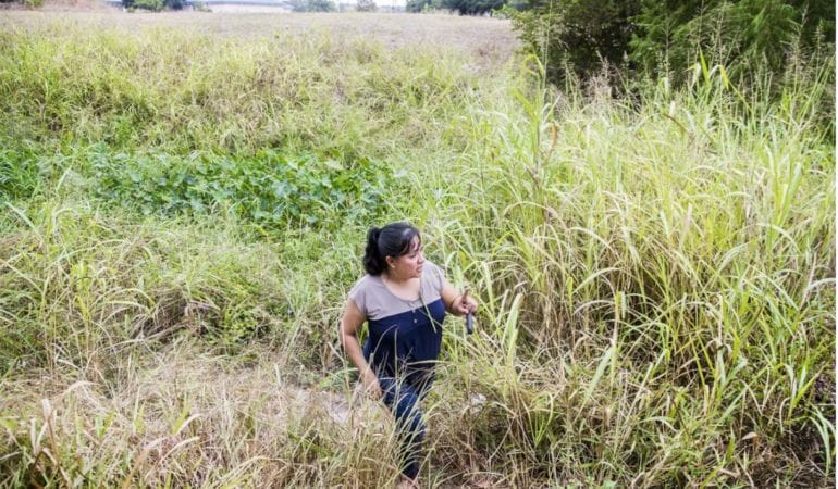
Imagen principal: Frances Acuña camina por el área de una cuenca de detención destinada a ayudar a proteger el barrio de Austin, Texas, en el que vive de las inundaciones. Crédito: Austin American-Statesman/USA TODAY Network.
FEMA NAC. 2020. “National Advisory Council Report to the Administrator”. Noviembre. Washington, DC: Agencia Federal para el Manejo de Emergencias.
Kaplan, Sarah y Andrew Ba Tran. 2022. “More Than 40 Percent of Americans Live in Counties Hit by Climate Disasters in 2021”. The Washington Post. 5 de enero.
La Casa Blanca. 2021. “Report on the Impact of Climate Change on Migration”. Octubre. Washington, DC: La Casa Blanca.
Wing, Oliver E.J., y Paul D. Bates, Andrew M. Smith, Christopher C. Sampson, Kris A. Johnson, Joseph Fargione y Philip Morefield. 2018. “Estimates of Current and Future Flood Risk in the Conterminous United States”. Environmental Research Letters 13(3). Febrero.
Land Matters Podcast: The Quest for Zoning Zen: How Land Use Rules Are Poised for Reform
Zoning may not be something most people think about every day. But behind the scenes, local land use rules have been blocking affordable housing, hindering climate action, and exacerbating racial segregation, according to advocates for reform.
This conversation comes at a time when at least 10 states are moving forward to modify zoning at the local level—to remove restrictions on multifamily housing development near transit stations, for example. The rationale is that there’s not nearly enough affordable housing, and local land use regulations skew toward single-family homes on large lots, which are inevitably more expensive. That’s just one example of the kind of overhaul being proposed.
“I would argue that zoning is the most significant regulatory power of local government because it [not only] governs where we can put housing and factories and parks and shops . . . but it actually has significant impacts on the economy, and even I think the very structure of our society,” said Bronin, who has been a leader in a zoning reform effort called Desegregate Connecticut.
Why all the attention to zoning now? Gray, who has been active in the organization California YIMBY (Yes in My Back Yard), says many Americans are frustrated with the lack of affordable housing, and have been motivated to understand the factors behind that shortage.
“There’s a huge appetite from across the political spectrum for reform ideas here,” he said, as the affordability crisis intensifies not only in California but throughout the country.
The reform measures have included eliminating single-family-only zoning, clearing the path for modest increases in density where it is currently not allowed; lifting prohibitions on accessory dwelling units, such as carriage houses or apartments over garages; and reducing or eliminating excessive requirements to build parking at new developments, which drive up construction costs.
El Instituto Lincoln de Políticas de Suelo ha trabajado en América Latina y el Caribe por 29 años, 27 de los cuales estuvieron bajo el liderazgo del economista urbano Martim Smolka. El Instituto comenzó su trabajo en la región con el objetivo de ayudar a los líderes a enfrentar el desafío de los asentamientos informales en tiempos de rápida urbanización.
Desde entonces, el Instituto Lincoln ha trabajado con miles de planificadores urbanos, funcionarios de gobiernos locales, y otros gestores de políticas y profesionales a lo largo de América Latina y el Caribe para la creación de nuevas políticas que fomenten la equidad social y la sostenibilidad a través del uso efectivo del suelo y del financiamiento con base en el suelo.
El Instituto Lincoln ha contribuido a la adopción de la recuperación de plusvalías como método para la distribución equitativa de los beneficios y cargas de la urbanización, así como al financiamiento de infraestructura y otras inversiones en áreas marginales. El Instituto publicó el reporte de Smolka “Implementación de la recuperación de plusvalías en América Latina” en 2013, considerado una referencia en el tema. Dos años antes había publicado el reporte fundamental sobre el mejoramiento de los asentamientos informales “Regularización de asentamientos informales en América Latina”.
Con la jubilación de Smolka a principios de este año, el Instituto Lincoln tiene una nueva cara en la región, la economista Anacláudia Rossbach, quien asumió como directora para América Latina y el Caribe en agosto. Rossbach se desempeñó hasta hace poco como gerenta regional de Cities Alliance, donde contribuyó a la transferencia de conocimiento y mejores prácticas entre líderes en políticas urbanas y de vivienda. Anteriormente, fue coordinadora de proyectos para el mejoramiento de asentamientos informales en Brasil, fundó una organización no gubernamental, y también fue parte del Banco Mundial como especialista sénior para vivienda.
En esta entrevista editada, Anacláudia Rossbach habla sobre el trabajo del Instituto Lincoln en América Latina y el Caribe, y los desarrollos que pueden esperarse para la región en los próximos años.
Will Jason: ¿Conocía al Instituto Lincoln antes de enterarse de este cargo?
Anacláudia Rossbach: El Instituto Lincoln me era bastante familiar porque tiene una gran reputación en América Latina. Entre las entidades que trabajan en temas urbanos, el Instituto Lincoln es muy conocido y cuenta con una red muy fuerte. Y yo entendía el gran impacto: no es difícil encontrar a alguien que trabaje en un municipio, en un gobierno nacional, que haya sido parte de los programas educacionales del Instituto.
WJ: ¿Cuál cree que es el mayor valor que el Instituto Lincoln ha entregado a la región?
AR: Creo que hay mucha más conciencia con respecto al rol fundamental que tiene el suelo en la planificación y el desarrollo urbano. El tema de la recuperación de plusvalías ha sido bien introducido en la región, por lo que hoy las personas, los profesionales y todos quienes trabajan en los municipios comprenden la importancia de la recuperación de plusvalías.
Si se compara el panorama de hace 20 años y el de hoy, se puede ver que actualmente en América Latina tenemos muchas ciudades que han introducido instrumentos de financiamiento con base en el suelo o instrumentos más avanzados de administración de suelos en la planificación urbana. Se ven cambios en los marcos legales nacionales de los países.
Pero por supuesto, todavía tenemos un largo camino por delante porque, bueno, la informalidad aún está muy presente en la región. Es la región más desigual del mundo. Se puede ver que las ciudades están segregadas, esto es visible.
WJ: ¿Cuál cree que es el rol más importante que el Instituto Lincoln puede continuar ejerciendo? ¿Y qué tipo de cambios las personas de la región pueden esperar del Instituto Lincoln a partir de este momento?
AR: Por supuesto que el Instituto Lincoln no cambiará la posición que ha promovido por largo tiempo, pero creo que necesitamos poner más atención a la informalidad. Notamos que durante la pandemia estos asentamientos informales, estas ocupaciones informales en nuestras ciudades sufrieron, y si bien aún no tenemos números, creo que podríamos ver alguna expansión de la informalidad del suelo en América Latina. Ya sabemos que tenemos más pobreza.
La pobreza ha aumentado durante el COVID y tenemos tasas de desempleo más altas en los países de la región. Entonces, la vivienda será menos asequible y, por lo tanto, la probabilidad de que se creen ocupaciones informales aumentará. Debemos ser inteligentes para saber combinar medidas preventivas y correctivas a través de instrumentos de administración del suelo, planificación urbana, estrategias para viviendas de bajos ingresos y mejoramiento de asentamientos informales para ser capaces de enfrentar la magnitud del problema que enfrentamos hoy y que enfrentaremos en el futuro si las condiciones actuales se mantienen.
El otro asunto es que hemos estado desarrollando capacidades en la región por un tiempo, pero necesitamos encontrar una manera para extender el alcance de lo que hemos estado haciendo. Tenemos muchas ciudades en la región, tenemos una situación clara de falta de capacidad a nivel de las ciudades, y hablo de ciudades de diferentes tamaños. Debemos pensar estratégicamente cómo podemos sacar ventaja de nuestro impacto y tener un mayor alcance en términos del aumento de capacidad.
Y luego, por supuesto, debemos ser capaces de medir de mejor manera nuestro impacto.
¿Cómo podemos encontrar maneras de generar mediciones cualitativas del impacto, o incluso mediciones cuantitativas del impacto que estamos generando en la región? Veo un gran potencial del Instituto Lincoln para aumentar el impacto en la región a través de asociaciones y alianzas. El Instituto ya ha estado trabajando a través de asociaciones, comunidades de práctica y redes, pero creo que en el futuro necesitamos reforzar y aumentar las asociaciones que hemos generado en el pasado.
Y por supuesto, necesitamos abordar al gran desafío que todos enfrentamos, que es el cambio climático. En América Latina tenemos una situación en que los más vulnerables, los más pobres de las ciudades, son los más afectados por el cambio climático. Aún tenemos muchas personas sin agua en la región. Tenemos este importante desafío bajo la gran sombra del cambio climático, que afecta a una parte importante de la región, una región que contribuye en menor medida a las emisiones globales pero que es afectada en mayor medida por los desastres y por sus consecuencias.
WJ: Volvamos a la distinción que hizo cuando estaba hablando sobre la informalidad, entre medidas correctivas y medidas preventivas. ¿Podría explayarse más sobre qué ha hecho y qué podría hacer el Instituto Lincoln en cada una de estas áreas, que son muy distintas?
AR: No sé si son tan distintas; creo que están interrelacionadas. Necesitamos reforzar la manera en que prevenimos la aparición de la informalidad. Y esto es lo básico: entregar para la construcción de viviendas suelo bien localizado y con servicios. Es más barato proveer infraestructura al comienzo que instalar servicios retroactivamente en los asentamientos informales. También necesitamos asegurar la disponibilidad de viviendas de bajos ingresos a través regulaciones para viviendas inclusivas u otras regulaciones.
Pero la informalidad ya está ahí y afecta nuestras vidas diarias. ¿Qué aspectos de las políticas de suelo el Instituto puede utilizar como medidas correcticas? Regularización del suelo, por ejemplo. En Brasil, por nombrar un caso, incluso tenemos empresas que realizan regularización del suelo. Es un mercado, es una política pública.
Pienso que podemos encontrar maneras para apoyar este tipo de iniciativas: mejorar los asentamientos informales a través de una combinación entre regularización del suelo, desarrollo de infraestructura, acceso al agua y protección de los ambientes naturales. Todas estas son áreas que pueden ser miradas holísticamente. El suelo es parte de un tejido vivo, donde todas estas cosas están sucediendo y donde la gente vive.
WJ: ¿A su juicio, qué rol jugará la recuperación de plusvalías en la regularización?
AR: La recuperación de plusvalías podría financiar la regularización, como fuente de fondos, porque es un instrumento que se desarrolla a nivel de ciudades. Usualmente, para las grandes regularizaciones o programas de mejoras, las ciudades dependen de los gobiernos nacionales o de subsidios nacionales.
Pero también al regularizar el suelo lo estamos incorporando al mercado. Estamos mejorando la capacidad de la ciudad como un todo para sacar ventaja de la recuperación de plusvalías porque estamos creando un nuevo activo en la ciudad.
WJ: En un tema más liviano, ¿qué país de América Latina tiene la mejor comida? ¿Cuál tiene la mejor música?
AR: Esa es una pregunta capciosa, porque me gustan muchos tipos de música y de comida de América Latina. Pero debo confesar mi amor eterno a México. Pienso que el país tiene comida increíble y, en general una cultura muy rica. Me gustan especialmente las voces femeninas de la escena musical mexicana actual.
Imagen: Anacláudia Rossbach.
Meet the Lincoln Institute’s New Director for Latin America and the Caribbean
The Lincoln Institute of Land Policy has worked in Latin America and the Caribbean for 29 years—the past 27 of them under the leadership of urban economist Martim Smolka. The institute entered the region with the goal of helping leaders to address the challenge of informal settlements at a time of rapid urbanization.
Since then, the Lincoln Institute has worked with thousands of urban planners, local government officials, and other policy makers and practitioners throughout Latin America and the Caribbean, contributing to new policies to promote social equity and sustainability through effective land use and land-based financing.
The Lincoln Institute has contributed to the adoption of land value capture as a method to equitably distribute the benefits and burdens of urbanization, and to finance infrastructure and other investment in marginalized areas. The institute published Smolka’s authoritative report on the subject, Implementing Value Capture in Latin America, in 2013, two years after its foundational report on the upgrading of informal settlements, Regularization of Informal Settlements in Latin America.
With Smolka’s retirement earlier this year, the Lincoln Institute has a new face in the region, Anacláudia Rossbach, who took over as director for Latin America and the Caribbean in August. An economist, Rossbach joins the Lincoln Institute from Cities Alliance, where she served as the regional manager for Latin America and the Caribbean, supporting the transfer of knowledge and best practices among leaders in housing and urban policy. Previously, Rossbach oversaw major slum upgrading projects in Brazil, founded a nongovernmental organization, and served as a senior housing specialist for the World Bank.
In this edited interview, Rossbach speaks about the Lincoln Institute’s work in Latin America and the Caribbean, and potential developments in the region in the coming years.
Will Jason: How familiar were you with the Lincoln Institute before you learned about this position?
Anacláudia Rossbach: I was quite familiar because the Lincoln Institute has a strong reputation in Latin America. Among stakeholders working on urban issues, the Lincoln Institute is very well known and has a very strong network. And I understood the huge impact. It’s not difficult to find someone working in a city, in a national government, that has been part of a Lincoln Institute educational program.
WJ: What do you see as the greatest value that the Lincoln Institute has been delivering to the region?
AR: I think there is more awareness around the key role that land plays in urban planning and development. The topic of land value capture was very well introduced in the region. Today, people, professionals, practitioners working in cities, they understand the importance of land value capture.
If you look at the big picture 20 years ago and now, you see that today in Latin America, we have many cities that have introduced land-based finance instruments or more advanced land management instruments in urban planning. You see changes in the national legal frameworks of countries.
But still, of course, we have a long way to go because, well, informality is still very prevalent in the region. The region is the most unequal in the world. You see the cities are segregated; this is visible.
WJ: What do you see as the most important role that the Lincoln Institute can continue to play? And what types of changes can people in the region expect from the Lincoln Institute now?
AR: Of course, the Lincoln Institute will not change the position that it has been advocating for a long time, but I believe that we need to pay more attention to informality. We noticed during the pandemic how these informal settlements, these informal occupations in our cities suffered, and we don’t have numbers yet, but I believe we might see some expansion in the informality of land in Latin America. We know that we have more poverty already.
Poverty has grown during COVID and we have higher unemployment rates in the countries in the region. So, housing will be less affordable and then the likelihood to create informal occupations and so on will increase. We have to really be smart on how to combine preventive and curative measures through land management instruments, urban planning, low-income housing strategies, and slum upgrading to be able to address the size of the problem that we face now, and will face in the future if the current conditions prevail.
The other thing is that we have been building capacity in the region for a while, but we need to see a way to extend the outreach of what we have been doing. We have many cities in the region, we have a clear situation of lack of capacity at the city level, and I’m talking about different sizes of cities. We need to strategically think how we can leverage our impact and have a bigger outreach in terms of building capacity.
And then, of course, we should be able to measure our impact more. How can we find ways to go for qualitative assessments of the impact or even quantitative assessments of the impact that we are generating in the region? I see a great potential for the Lincoln Institute to increase impact in the region through partnerships and alliances. The institute has been already working through partnerships, communities of practice, and networks but I believe in the future we need to strengthen and add to some of the partnerships that we have been generating in the past.
And of course, we need to address the big challenge that we all face, which is climate change. We have, in Latin America, a situation where the most vulnerable, the poorest in the city, are most affected by climate change. We still have many people without water in the region. We have this major basic challenge in the region under this big shadow of climate change, which is affecting a lot of the region, a region that contributes less to emissions globally, but is being highly affected by disasters, by the consequences.
WJ: Let’s come back to the distinction that you made when you were talking about informality, between curative measures and preventive measures. Could you please talk a little bit more about what the Lincoln Institute has done and could do in each of these two areas, which are very distinct?
AR: I don’t know if they’re so distinct; I think they are interrelated. We need to strengthen the way we prevent informality from taking place. And this is, well, the basics: provide well located, serviced land for housing. It’s cheaper to provide infrastructure at the beginning than it is to retrofit slums with services later. We also need to make sure there are low-income housing options available through inclusionary housing or other regulations.
But informality is already there, and it’s affecting our daily lives. What are the aspects of land policy that the Institute can use as a curative measure? Land regularization, for example. In Brazil, for instance, we even have companies doing land regularization. It’s a market, it’s a public policy.
I think we can find ways to support these kinds of initiatives—improving informal settlements through a combination of regularization of land and infrastructure improvement, access to water, and protection of natural environments. These are all areas that we can look at in a more holistic manner. Land is part of a living tissue, where you have all these things happening and you have people living.
WJ: What role do you see land value capture playing in regularization?
AR: Land value capture could finance regularization, as a source of funding, because land value capture is an instrument that is developed at city level. Usually, for big regularization or upgrading programs, cities depend on national governments, on national grants.
But also, once you regularize land, you are bringing land to the market. You are adding value to the city. You are improving the capacity of the city as a whole to leverage land value capture because you’re bringing a new asset to the city.
WJ: On a lighter note, which Latin American or Caribbean country has the best food? Which has the best music?
AR: This is a tricky question, because I am very fond of many types of Latin American music and food. But I need to confess my eternal love for Mexico. The country has amazing food, and to me a very rich culture overall. I particularly like the female voices from the Mexican contemporary musical scene.
Will Jason is the director of communications at the Lincoln Institute of Land Policy.
Zoning is often considered a timeless element of land policy and planning. And it is. Zoning originated in Asia more than three millennia ago. In those days, it was used to designate land uses behind city walls or to separate people by caste. The practice was adopted more recently in the United States to pursue similar ends. It is now one of the biggest impediments to sustainability in U.S. cities in the 21st century.
I’ve made my feelings about hyperlocal land control known for many years. A decade ago, on a panel with Nic Retsinas, then director of the Joint Center for Housing Studies at Harvard, I opined that home rule and local land use controls were “dinosaurs” that made it almost impossible to coordinate regional transportation planning and affordable housing efforts. Nic reminded me and the audience that powerful political and economic forces stood firmly in the way of land policy reform. And he noted that dinosaurs lasted for millions of years before becoming extinct—because of a random asteroid colliding with Earth, not natural selection.
But now, something almost as rare as a planet-changing asteroid is afoot in the world of land policy—bipartisan agreement. Numerous blue, red, and purple states have passed or are contemplating efforts to preempt local zoning so they can advance critical policy objectives. Why the sudden shift? Because many policy makers now understand that the national affordable housing crisis cannot be addressed without structural changes to the rules of the game. Other policy makers know that we cannot address one of the ugliest manifestations of zoning—spatial segregation by race and class—without aggressive affirmative action.
Although we are seeing bipartisan agreement on the need for reform, the motivations of policy makers are quite different. Advocates from the right argue that the housing crisis is an artifact of overregulation that stifles housing production. These critics believe zoning reform will unleash market forces that will confront the housing crisis by accelerating new production. Advocates from the left argue that we cannot build affordable housing in places we need it most because of land policies that have effectively excluded people based on race and income for generations, such as minimum lot sizes and bans on multifamily housing. Zoning reform will make it possible, they say, to build affordable housing in “high opportunity” places with good schools and decent jobs.
State preemption of local zoning is not new. In 1969, Massachusetts passed Chapter 40B, a measure that allows the state to override local zoning and approve mixed-income, multifamily developments in jurisdictions with little affordable housing. Although it has helped to promote some affordable housing development in some affluent suburbs, it was not a game changer, and few other states considered following suit, until very recently.
Now, some 10 states are ready to preempt local zoning to permit development of multiple housing units on lots that are currently zoned for single-family homes. These include the right to add accessory dwelling units (ADUs) to single-family lots in Connecticut, Nebraska, Utah, Oregon, Maryland, California, and Washington; approving “middle housing,” two- to four-family townhomes, on lots zoned for single families in Virginia, Utah, Nebraska, Washington, and Maryland; or complete preemption of local government efforts to prohibit multifamily housing development on single-family lots in Oregon, California, Virginia, Maine, and Washington. Massachusetts and California also recently mandated upzoning in “transit-rich” communities. Clearly, local control over land use is no longer sacrosanct.
Although zoning practice is thousands of years old, in the United States it is less than a century old, with a few exceptions. States began granting municipalities the power to dictate land uses in the 1920s, based on the Standard State Zoning Enabling Act drafted by the Department of Commerce in 1923. But what states giveth, states can taketh away. It is sometimes necessary for higher levels of government to supersede the decisions of lower levels of government to promote general welfare or address negative externalities that are artifacts of uncoordinated actions at lower levels. Too often, state efforts to override local governments are misguided; for example, when state policy makers curry favor from voters by imposing property tax limits. In the case of zoning, the need for state action is clearly defensible.
We should celebrate the fact that we are moving in the right direction—mustering the political will to take on a challenge that was, until very recently, considered impossible. But we still know less about zoning than we should. Each state, and often individual jurisdictions in a state, developed its own zoning conventions, which makes it extremely difficult to compare zoning practices among them. It also makes it almost impossible to understand the implications of zoning decisions on land values, development patterns, or how zoning reform might address big challenges like the housing crisis, spatial inequality, or urban sprawl. This too is changing.
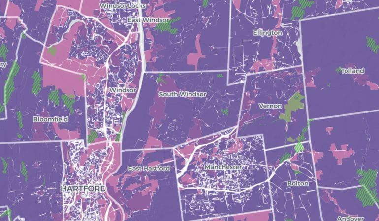
Last year, a small team of visionaries at Cornell Law School, led by Professor Sara Bronin, produced the first Zoning Atlas for the State of Connecticut. Using spreadsheets, maps, and geographic information systems, the team documented, with impressive granularity, residential zoning practices in 180 jurisdictions with 2,622 zoning districts. Incredibly, this required reviewing more than 30,000 pages of text describing zoning practices—in one state!
This herculean task apparently was not a big enough challenge for this plucky band of researchers. The Cornell team recently launched an effort to build a National Zoning Atlas. Now, with a field-tested methodology for creating the Zoning Atlas in Connecticut, they have set out to crowdsource zoning data from the rest of the country using the same methods. So far, self-organized teams in 11 states are participating. When they succeed at building the national atlas—and the Lincoln Institute of Land Policy will do all it can to make sure that happens—a new era of land policy scholarship will arrive. Debates about the costs, benefits, and consequences of zoning reform will be informed by real data.
Zoning reform alone is not sufficient to solve the national housing crisis. But it is necessary. And we need to know a lot more about current zoning practices, and the potential benefits of improved zoning practice, to address the ills generated by decades of bad practice. A century of decentralized and isolated local control of land produced unacceptable levels of racial and economic segregation, urban sprawl that contributed to the climate crisis, and an almost unassailable affordable housing crisis. With the unprecedented alignment of political will with new tools and knowledge, possible solutions to this triple threat are closer than they have ever been.
George W. McCarthy is president and CEO of the Lincoln Institute of Land Policy.
Image: The interactive Connecticut Zoning Atlas is the first stage of a national effort to document zoning across the United States. Credit: National Zoning Atlas.
Mayor’s Desk: Addressing Affordability in Berkeley
This interview has been edited for length and clarity. The full conversation is available as a Land Matters podcast.
Jesse Arreguín was elected mayor of Berkeley, California, in 2016, becoming the first Latino to hold the office and, at 32, the youngest mayor in a century. The son and grandson of farmworkers, Arreguín grew up in San Francisco. At nine, he helped lead efforts to name a city street after activist Cesar Chavez, beginning a lifelong commitment to social justice.
After Arreguín graduated from the University of California, Berkeley, he stayed in the city, serving on boards including the Housing Advisory Commission, Rent Stabilization Board, Zoning Adjustments Board, Planning Commission, and City Council. As mayor, Arreguín—who is also president of the Association of Bay Area Governments—has prioritized affordable housing, infrastructure, and education. He recently met with Senior Fellow Anthony Flint at City Hall to talk about this city of 125,000, with a focus on housing and the task of building more of it. Fittingly, the sounds of construction could be heard outside the fifth-floor office suite.
ANTHONY FLINT:It seems like Berkeley has become a national symbol of the YIMBY/NIMBY [Yes in My Back Yard/Not in My Back Yard] divide. What should developers be contributing to increase supply, provide different housing options, and increase density at appropriate locations?
JESSE ARREGUÍN: I think a lot needs to be done by government, and we’re seeing a lot of leadership being demonstrated by our governor, by the state legislature, by our attorney general, who established a housing strike force to enforce state housing laws, and by regional and local government. In Berkeley, over the past several years, we have taken significant steps to pass laws to streamline production and encourage a variety of different housing options in our community.
We’ve also made a commitment that we are going to end exclusionary zoning. I think part of the reason why Berkeley is a symbol of the debate happening in cities throughout the country is because Berkeley is the birthplace of exclusionary zoning. In 1916, the city adopted its first zoning ordinance to zone the neighborhoods in the Elm-wood District as single-family to prevent the construction of a dance hall. Not surprisingly, many people who would frequent that dance hall would predominantly be people of color. Sadly, single-family zoning was founded on the foundation of racial exclusion.
My perspective on zoning, on housing issues, has evolved over the years, because the crisis in Berkeley and in California has worsened significantly in the past five years. We have increasing numbers of people who are experiencing homelessness, tent encampments on our streets, working families who can’t afford to live in the community they work in, students who can’t afford to live in the community they go to school in. The status quo is not working, and we need to take bold action.
I think developers are eager to see leadership on the part of government. We need to meet them at the middle and we have to do what we can to make it easier for them to build. At the same time, we have to make sure that they are providing community benefits while we are seeing market-rate construction, particularly in communities where we’ve seen significant amounts of displacement and gentrification. We have historically Black neighborhoods where we’re seeing homes sell at $2 million. Our Black population has declined from 20 percent in 1970 to seven percent now. I think that is a direct result of the decisions that government made to not build housing, and of the astronomical cost of housing in Berkeley.
AF:Let’s talk about gentrification and real estate speculation, a problem in many cities. Los Angeles recently started a program of land banking parcels near transit stations. Is that the kind of thing that is going to be necessary when you’re obviously in white-hot market conditions here?
JA: I think so, and we are prioritizing public land for affordable housing. We’ve converted parking lots to affordable housing projects. We have one being constructed right up the street, 140 units of affordable housing and permanent supportive housing—the largest project we’ve ever built for housing the homeless. We need to prioritize public land for public good. There’s no question about that.
I do agree we need to look at land banking. We need to provide money so nonprofit developers can buy parcels to keep them permanently affordable. We need to look at how we can support land trusts, not just buying properties but buying buildings to keep them permanently affordable. That is part of Berkeley’s housing strategy. It’s not just building new construction, but also the preservation of existing naturally occurring affordable housing. I think we need to focus on the three P’s, and I say this often: production of new housing, preservation of existing naturally occurring affordable housing, and protection of existing residents from displacement.
AF:How might a vacancy tax, similar to what we see in San Francisco and Oakland, address this issue of the burgeoning value of land?
JA: We actually recently placed on the ballot a residential vacancy tax, which is a little bit different from Oakland’s; it doesn’t focus on vacant parcels, but it’s focused on vacant homes and vacant residential units. There are some who have said, “Well, we have thousands of vacant units, and therefore, we don’t need to build more housing.” That’s absurd. We need to build housing, and we also need to put housing that is off the market back on the market.
The more that we can address actions by speculators and by scofflaws—I would characterize people who keep properties blighted and vacant for many years as scofflaws—it will address the artificial constraining of the market and will put more units back on the market. We spent a lot of time crafting this vacancy tax and really thought through the situations in which units could be vacant legitimately. The focus is not on small property owners but on owners of large rental properties, because part of what we are seeing is, frankly, speculation of the market.
We hope, at some point, we don’t have to charge a tax because all the housing is being rented or is being used. That’s the goal of the vacancy tax, not to penalize but to incentivize owners of multifamily properties to use the properties for their intended purpose. I just have to say once again that this is not a panacea, this is not the solution to the housing crisis, and that we need to build new housing. What we have is a crisis that is decades in the making through deliberate actions on the part of government, through racial segregation or redlining, through fierce resistance to building housing, and through policies that have constrained the production of housing.
AF: As a hub of innovation, Berkeley has a thriving economy. Do you believe it’s going to be possible for more workers in Berkeley to be able to live in Berkeley, or is there a built-in imbalance that you just have to manage and come to terms with?
JA: I think it’s possible . . . but that’s going to require that we build thousands and thousands of units of housing, that we prioritize building housing around our transit stations, that we look at upzoning low-density commercial neighborhoods, that we look at building multifamily housing in residential neighborhoods. Every part of our city needs to meet its responsibility to create more housing. No part of our community can be walled off to new people living here.
I really do think that that gets to the core of who we are, who we say we are as a city. Are we a city of equity and inclusivity? If we are, then we need to welcome new people living in our community. We create those opportunities for people to live here. People who previously lived here and were displaced, people who work here but can’t afford to live here, and obviously, there’s a climate benefit we can give people to not have to drive an hour, two hours to get to Berkeley.
That reduces those cars on the road, reduces greenhouse gas emissions, and helps us mitigate the impacts of climate change, and building dense, transit-oriented development is a critical part of taking bold climate action. Our land use policies and our actions to encourage more dense housing are really critical climate action strategies.
AF: Could you talk about the importance of bicycle and pedestrian safety in your view of how the city functions and how Berkeley is doing in that regard?
JA: Because we have such high numbers of people who bike to work and walk and use alternative modes of transportation, we need to make it safer and easier for people to get around town. Sadly, we’ve seen an increasing number of collisions between cars and bicyclists, and pedestrians. Like many communities, we’ve adopted a vision zero policy that’s focused on reducing traffic injuries and fatalities. We are looking at how we can redesign and reconstruct our streets to make them safer for people who walk and bike. . . . Then, obviously, being the home of the University of California, we have a lot of young people who are constantly walking, biking around, and we need to make it safer for students and for our residents to get out of their cars and to choose non–carbon intensive modes of mobility.
AF: On climate, what else can Berkeley do? How is this region addressing the climate crisis?
JA: I think the best way for Berkeley to address the climate crisis is through recognizing, one, it’s not a crisis, it’s an emergency—and we see the real material effects of it here in California. We’ve had some of the most devastating wildfires in California history over the last five years, [and] Berkeley is not immune to the threat of wildfire. That’s a pretty telltale sign that the climate emergency is here, it’s not going away, and we have to recognize that we need to take bold action.
I’m proud that Berkeley has really been a leader in combating climate change. We were one of the first cities to adopt a climate action plan. Obviously, building dense infill housing is a critical part of that. We do need to promote more electric mobility, whether it’s through micro-mobility or through converting heavy-duty and light-duty vehicles to electric, and California’s really been a leader at that. While there are very ambitious targets that the state has set to transition our vehicle fleet to electric, we don’t have the infrastructure to support that yet. We hope with the new federal bipartisan infrastructure law and the climate law that was just passed that there’ll be significantly more resources available that we can leverage to expand that infrastructure in California.
Electrifying our buildings is important too, and Berkeley was the first city in California to adopt the ban on natural gas and require that newly constructed buildings be all electric. We’re also looking at how we can get existing buildings to be electric, which is much tougher. . . . All those things are important, but we also have to adapt to climate change . . . whether it’s how we address wildfire risk or sea-level rise. Berkeley’s along the San Francisco Bay. We know that parts of our city, unless we do something, are going to see significant flooding and inundation.
That’s where I think the regional approach comes in. These [issues] can’t be solved by one city. A lot of work’s been done at the Metropolitan Transportation Commission and Association of Bay Area Governments—our regional planning agency and council of governments—to bring government agencies together to explore strategies. I think that’s an area where regionalism and regional government’s going to make a difference.
Anthony Flint is a senior fellow at the Lincoln Institute of Land Policy, contributing editor to Land Lines, and host of the Land Matters podcast.