Topic: Land Use and Zoning

Portland

Gentle Infill

Boomtowns Are Making Room for Skinny Homes, Granny Flats, and Other Affordable Housing
By Kathleen McCormick, January 25, 2018

Recent news stories routinely feature “hot market” U.S. cities with astronomical housing prices that end up displacing residents with moderate or low incomes. San Francisco’s epic housing battles pit longtime residents against tech workers. In Portland, Oregon, city council extended the state of emergency it declared in 2015 to address the local affordable housing crisis. In Denver, Mayor Michael Hancock pledged $150 million for affordable housing in the next decade. Boston Mayor Martin J. Walsh plans to build 53,000 units by 2030, while neighboring Cambridge adds density in infill areas and near transit. And in Boulder, Colorado, public officials seek to add a host of housing options through an approach they call “gentle infill.” 

“Hot markets exist for many reasons, but in Portland, San Francisco, Boulder, and other cities, housing issues are clearly a result of strong economic development,” says Peter Pollock, FAICP, manager of Western programs for the Lincoln Institute of Land Policy. In these places, a jobs-housing imbalance leads to inadequate shelter options. The “gentle” or “sensitive” infill approach is about “trying to find ways to make infill compatible with surroundings to achieve urban design goals and enable production of more housing,” he says. The term also “puts a positive spin on something that may not be universally accepted”—namely, density—“and suggests that we can do a better job.”

While half of all households nationwide are spending more than 30 percent of their income on housing, many residents in hot market cities are spending more than 50 percent and being forced to leave. Housing activists, such as those at the annual U.S. YIMBY (“Yes in my backyard”) gathering, are challenging city planners and elected officials to create more diverse infill options to house people, stem displacement, make better transit connections, and create more environmentally sustainable communities.

How Did We Get Here?

Desirable cities are growing rapidly because they’re attracting millennials and cultural creatives for job opportunities and lifestyle amenities, and the newcomers have gravitated in numbers that far exceed places to live. The tech industry, with its influxes of well-paid workers, is often blamed for driving up housing costs and causing displacement. But other factors are also in play. Many cities built little if any housing during the Great Recession. Mortgage credit is tighter. Construction costs are escalating. New housing is priced at market rates that drive up the cost for existing homes. Zoning that favors single-family detached houses or luxury apartments has led to expensive housing monocultures. What’s being viewed as a crisis in many cities is the loss of housing not just for lower-income residents but also for workforce and middle-income residents—teachers, nurses, firefighters, small business owners, young professionals, young families, and others who typically provide a foundation for communities.

Restoring the “Missing Middle”

The good news is that cities across the United States are already working on solutions. Communities are overturning policies that prohibit housing or place tight restrictions on where and how it can be built, to allow for more diverse and affordable places to live. Many urban planners and public officials are focused on developing housing types that restore the “missing middle,” to shelter moderate and middle-income households. 

The missing middle, a concept that grew out of new urbanism, includes row houses, duplexes, apartment courts, and other small to midsize housing designed at a scale and density compatible with single-family residential neighborhoods. Since the 1940s, this type of development has been limited by regulatory constraints, the shift to car-dependent development, and incentives for single-family home ownership. Three- or four-story buildings at densities of 16 to 35 dwelling units per acre used to be a standard part of the mix in urban neighborhoods. Many urban planners say this scale and density of housing is needed again to offer diversity, affordability, and walkable access to services and transit. Cities are using a variety of additional approaches to inject more moderately priced housing into residential neighborhoods, from shrinking or subdividing lots to adding accessory dwelling units (ADUs) to expanding legal occupancy in homes. Some of these gentle infill approaches are showing great potential or in fact adding needed units on a faster track. 

How does gentle infill work? It depends on the city, as demonstrated by the following examples from Portland, Oregon; Boulder, Colorado; and Cambridge, Massachusetts.

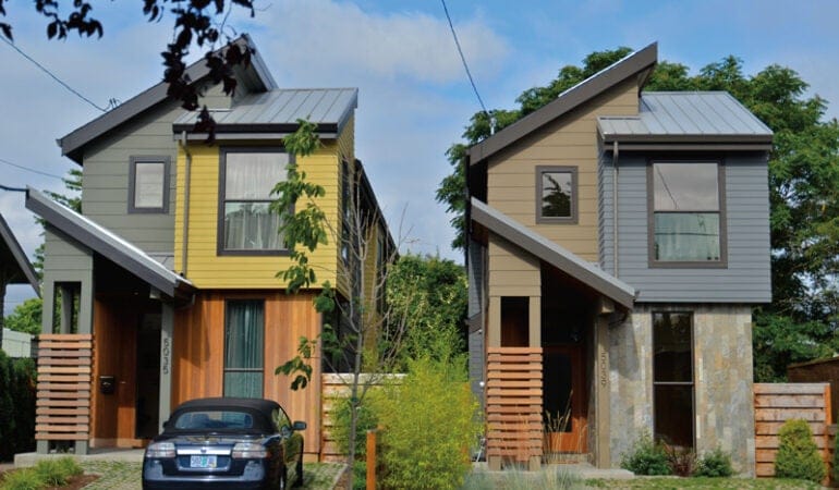
Portland, Oregon: More Housing is Better

Portland typically ranks atop lists of “best places” to live but has recently slipped a few notches because of its housing prices, which ballooned 13 percent in 2015. According to a recent study released by Metro, the regional government organization, Portland area rents increased 63 percent since 2006, while the average income of renters rose only 39 percent. The population grew by 12,000 in 2015, to more than 632,000 residents in 250,000-plus households. 

Since 1973, Portland has been living with statewide urban planning that mandates an urban growth boundary to protect farmland and forests from urban sprawl and to ensure efficient use of land, public facilities, and services within the urban boundary. This city has an ambitious agenda to meet its growth projections with several big planning efforts: a new zoning map and the 2035 Comprehensive Plan, its first update in 30 years, adopted by city council in June 2016; a new land use code with regulations that affect a range of growth from multifamily and mixed-use development to transportation corridors and parking; and Central City 2035, a long-range development plan for the city center and its districts. 

The city is relying on policy changes in view of the 142,000 additional jobs, 135,000 extra households, and 260,000 more people that it will need to accommodate by 2035, according to Metro. About 30 percent of new housing will be built in the city center, 50 percent in mixed-use centers and corridors, and 20 percent in Portland’s single-family residential zones, which comprise about 45 percent of the city’s 133 square miles of land. The city has about 12,000 buildable lots, assuming that some current lots can be subdivided to provide more sites.

Since 2010, an estimated 20,000 new residential units have been built or are in the pipeline, and tax increment financing in designated urban renewal areas has invested $107 million in new and preserved affordable housing. In 2016, the state legislature lifted a 17-year ban on inclusionary zoning, which will allow the city to require builders to set aside units for new workforce housing. The city is focused on funding strategies to provide more affordable homes for households below 80 percent of the area median income (AMI). To increase the number of middle-income units for people earning more than 80 percent of AMI, the city is relying on policy changes, rather than funding strategies.

By the end of 2016, a stakeholder advisory committee for the Residential Infill Project (RIPSAC) will provide advice regarding the size and scale of houses, small-lot development, and alternative housing types. One proposal under consideration is to allow more internal conversions of large historic houses into multiple units, an approach that would provide more housing while avoiding teardowns and preserving the historic fabric of neighborhoods. Building on the legacy of small homes that exist from a century ago, Portland is looking to add little houses on undersized, pre-platted lots. And the city is considering whether to allow the development of more tall “skinny” homes of up to 1,750 square feet on 2,500 square-foot lots, half the square footage of land required under R-5 single-family zoning.

“Five or ten years ago, people would ask, ‘Why is this house being built on a narrow lot?’” says RIP project manager Morgan Tracy. “Now it’s not so surprising. They’re really becoming popular because they’re at a lower price point for buyers.”

Policy changes regarding accessory dwelling units have helped generate new moderately priced housing and have drawn the attention of public officials from other cities in search of solutions to their own housing crises. ADU construction has exploded since 2010, when the city waived development fees covering sewer, water, and other infrastructure connections, reducing construction costs by $8,000 to $11,000 per unit. The waiver inspired a surge in construction: almost 200 ADUs were permitted in 2013—six times the yearly average from 2000 to 2009. In 2015, the city granted 350 new ADU permits, for a current total of more than 1,500 units. Tracy says ADUs “are a well-accepted means of producing more housing because they’re better integrated into a site and don’t necessitate a home being demolished.”

Any single-family house in the main zoning districts can have an ADU, and a proposal would allow up to two units—an interior apartment plus a separate carriage house or granny flat. The city does not limit the number of ADUs within a neighborhood or require off-street parking. It has also streamlined some ADU standards to allow for improved designs with slightly greater height and setbacks. RIPSAC is considering proposals to allow any house to have two ADUs, both interior and detached, triplexes on corner lots where duplexes are now allowed, and duplexes on interior lots, with a detached ADU. Allowing duplexes on interior lots and triplexes on corners “doesn’t mean everyone will take advantage” of the policy changes, says Tracy, noting that only 3 percent of corners now have duplexes. But “if every property owner took advantage of additional unit potential, we would double the number of housing units in each neighborhood.”

The next phase of infill housing policy considerations will address how medium-density housing types might fit into small infill and multi-dwelling sites. The city has already been moving in that direction: Portland’s Infill Design Toolkit guide focuses on integrating rowhouses, triplexes and fourplexes, courtyard housing, and low-rise multifamily buildings into neighborhoods.

“What may be shocking and alarming for some people becomes more acceptable as you see it more,” says Tracy. “We’re seeing that with duplexes and triplexes in single-family neighborhoods. The last time we built them was in the 1930s and ’40s. We’re trying to promote a wider diversity of housing forms, and some folks are supportive because they understand the need to be able to house more people on available land.”

Boulder: More Housing Is Better, But There Are Down Sides

Boulder is studying what other cities are doing to encourage gentle infill, and a recent trip to Portland by city officials, staff, and business leaders offered perspective on what could work at home. Like Portland, Boulder has determined to halve carbon emissions by 2030, provide more infill housing in the developed city core, protect open space, and encourage public transportation use. But with one-sixth of Portland’s population and different challenges and opportunities, Boulder seeks its own consensus on what gentle infill means.

Located 25 miles northwest of Denver in the foothills of the Rockies, Boulder also ranks high on the lists of healthy, livable, and entrepreneurial places. The natural beauty and high quality of life in this 25.8-square-mile city of 105,000 have attracted start-ups and established tech firms such as Google and Twitter. The influx has fed a digitally paced lifestyle and “1 percent” housing market in which the median single-family detached house costs over $1 million.

In the past two years, housing prices overall have risen 31 percent. Factors beyond the tech industry have limited affordability for many years (disclosure: for nearly 25 years, I’ve lived, worked, and raised two kids in a formerly modest Boulder neighborhood that has been largely rebuilt with higher-end homes). The University of Colorado-Boulder, a key economic driver with 38,000 faculty, staff, and students, generates significant housing demand. A jobs-housing imbalance translates to an estimated 60,000 cars arriving and departing daily, despite regional and local bus service.

State law prohibits rent control, and the state’s “condominium construction defects legislation” has squelched that type of construction for middle-income housing. Boulder is also home to many independently wealthy “trustafarians” and speculative buyers who purchase homes with cash from selling property in other high-end markets. Some are second or third residences; others are reserved for short-term rentals like airbnb. In June 2015, city council voted to restrict short-term vacation rentals, saying they impacted affordability and reduced the number of long-term housing opportunities.

Development limitations include few residential lots, a 45,000-acre ring of protected open space around the city, and a height limit, to preserve mountain views, capped at between 35 and 55 vertical feet, depending on planned development intensity and location near transit. The city is within sight of a theoretical build-out; a forecast of 6,760 additional units by 2040 is being considered for the current update of the Boulder Valley Comprehensive Plan. A 2015 housing survey conducted for the plan indicated that most residents were willing to increase density and building height to allow for more housing, at least in some parts of the city.

Since 1989, while the percentage of lower-income households has held steady, middle-income households have declined from 43 percent to 37 percent of the populace. The segment disappearing at the fastest rate is households earning between $65,000 and $150,000 as well as families with children. City council, the planning board, and local newspaper op-ed pages field lively debates over the “Aspenization” of Boulder and infill housing options that could slow or reverse the city’s momentum toward greater exclusivity and less diversity.

Boulder has been working on affordability and inclusivity for some time. Its inclusionary zoning ordinance produced 3,300 affordable housing units between 2000 and 2016. Developers of projects with five or more units are required to construct 20 percent as permanently affordable, build off-site, donate land, or make a cash-in-lieu payment to the city’s affordable housing fund. The city’s goal is 10 percent permanently affordable housing; some 7.3 percent of the city’s housing stock now qualifies.

Part of the affordable program is aimed at middle-income housing: the city has a goal of creating 450 permanently affordable units for households earning 80 to 120 percent of AMI. Between 2000 and 2016, 107 units for middle-income households were built in new mixed-income neighborhoods on land annexed in north Boulder. Many are in the Holiday neighborhood, a mixed-use model of 42 percent affordable units integrated within a total of 333 townhomes, row houses, flats, live-work studios, and cohousing. Recently built middle-income units are located in the Northfield Commons neighborhood, where half of the 43 percent of affordable units in duplexes, fourplexes, sixplexes, and townhomes are reserved for middle-income households.

“It’s very expensive to subsidize people making $70,000 to $130,000 per year,” says Aaron Brockett, a city council member and former planning board member, referencing a middle-income housing study prepared for the city that defined Boulder’s middle market as 80 to 150 percent of AMI. He advocates for “market solutions like smaller units as a trade-off in those areas that have amenities and services such as mixed-use areas where people can walk to transit and redeveloping areas.”

In preparing a comprehensive housing strategy, Boulder is exploring ideas for middle-income infill housing in transit corridors, commercial strips, business parks, and industrial areas that could be rezoned and redeveloped, and in walkable mixed-use neighborhood centers in residential areas. “The 15-minute neighborhood is the Holy Grail for a lot of communities, but it takes a lot of work,” says Jay Sugnet, project manager for Housing Boulder. “Are they in single-family neighborhoods or at the edge of service-industrial areas? Where are you willing to locate those, and what’s appropriate? You also need a concentration of people to support retail. Boulder has lots of commercial corridors, but they need a sufficient number of people to support all of them.”

The city also plans to adjust the ADU ordinance to achieve more middle-income affordability in neighborhoods of mostly single-family detached houses, which comprise about 41 percent of the city’s 46,000-unit housing stock. An ADU ordinance in effect since 1981 has permitted only 186 ADUs and 42 OAUs (owner’s accessory units) because of requirements regarding off-street parking, minimum lot size, and limits on ADU density. “We’d like ADUs for diversity of housing in neighborhoods,” says David Driskell, executive director of planning, housing, and sustainability. “Physically we could put in quite a few here, but, politically, there will be quite a lot of discussion about parking and traffic impacts.”

City council is considering “creative adjustments” to existing housing that could have less impact on the footprint and “character” of residential areas, such as loosening code restrictions on the number of unrelated people who can share a home. In most residential zones, no more than three unrelated people can share a house, even if it has six bedrooms and multiple bathrooms. A ballot measure petition launched recently by University of Colorado graduate students asks Boulder voters to overturn the occupancy limit and adopt a “one person = one bedroom” policy. Allowing higher occupancy is controversial. Although it would provide more places for students and others to live legally, it could further drive up housing costs for families, as monthly rent in group houses, particularly close to the university, often costs as much as $1,000 per bedroom.

The city is also discussing a revision of its 20-year-old cooperative housing ordinance. No co-op projects have been permitted because the ordinance was “essentially a path to No,” says Driskell. Three affordable rental co-ops were established under other measures. City council is considering a more welcoming ordinance that supporters say would benefit the city by offering a sustainable and community-oriented lifestyle for single residents, young families, seniors, and people who work lower-wage jobs.

“We tend to be a regulatory city, and we have really embraced deliberative planning,” says Susan Richstone, deputy director of planning, housing, and sustainability. “It hasn’t always been easy, but we’re having the discussions and making changes in planning and zoning levels within a regulatory framework. It’s in our DNA.”

“Density is a bogeyman here, and people are up in arms,” says Bryan Bowen, an architect and planner who is a member of the Boulder Planning Board and the city’s Middle Income Working Group.  Residents are anxious about both modest homes being scrapped and replaced with 5,000 square-foot $1.5 million new homes and the possibility of greater density with more large edgy-looking multifamily apartment buildings. “That’s probably why gentle infill feels good, though it has an interpretive quality. It’s a question of what people find to be compatible and palatable.” There’s no consensus yet about which infill approach will work best, Bowen says. “But frankly, in moderation, some application of all of them might be needed.”


Accessory Dwelling Units (ADUs): A Preferred Infill Housing Approach

Demographic changes such as aging populations, shrinking household size, college-loan-strapped millennials, and cultural preferences are leading many cities to allow home owners to build ADUs, also known as in-law apartments, granny flats, and carriage houses. Advocates say ADUs—built in the interior of a home, rebuilt from a garage, or newly built as a separate cottage—offer affordable options for elderly parents, adult kids, and caregivers. They’re also a source of rental income that can help residents stay in their homes. As older home owners wish to downsize and age in place, some are choosing to live in the ADU and rent out their main house.

Typically ranging from 200 square feet to more than 1,000 square feet, ADUs are part of a long tradition of modest apartments and multigenerational houses that were common before the era of single-family suburban homes. Many housing advocates are keen on ADUs as a way to add units quickly, with home owners financing the infill of existing neighborhoods, compared to the lengthy and costly process of land acquisition and development of larger-scale multifamily projects by municipalities, nonprofit affordable housing organizations, and private developers. At Denver’s Bridging the Gap housing summit in May, a session on small-scale affordability posed a potential scenario for the city: 70 neighborhoods multiplied by 300 ADUs per neighborhood would equal 21,000 moderately priced housing units.

At the 2015 YIMBY conference in Boulder, Susan Somers of AURA (formerly Austinites for Urban Rail Action) in Austin, Texas, described a coalition effort to become “an ADU city” and achieve much greater housing density in the mostly single-family detached city. They accomplished their mission; in November 2015, the Austin City Council passed a resolution relaxing ADU regulations and allowing them on smaller lots. AURA hopes to help home owners entitle 500 new ADUs annually. The units provide “affordable housing and a source of income to allow folks to stay in their homes,” says Somers. In gentrifying East Austin, “this is how families stay together.”


Cambridge: Bridging the Income Gap

Cambridge, located across the Charles River and three miles west of Boston, has the most expensive housing in Massachusetts and bears keen pressure to produce more missing-middle options. The population has increased more than 10 percent since 2000, to 110,000 residents within a compact 6.5 square miles, and is projected to grow by 6,200 homes before 2030, according to the Metropolitan Area Planning Council (MAPC), the regional planning agency for Metro Boston. The city has 117,000 jobs and more than 52,000 housing units, about half of them located in mixed-use commercial areas. The average listed single-family home price in 2015 exceeded $1.2 million. Median monthly rent for a one-bedroom apartment was $2,300.

“Cambridge has become a bifurcated place of very high income and very low income,” says Andre Leroux, executive director of the Massachusetts Smart Growth Alliance. “It’s hard for middle-class people to live there.” Cambridge has the infrastructure to support much greater density and to add significantly more residential development and huge residential towers, “but it doesn’t want to be downtown Boston.”

The city is in the first year of a three-year comprehensive plan process, its first since 2000 (the state does not require municipalities to develop comprehensive plans). Affordable housing for low, moderate, and middle incomes—a resounding theme through the public process—is the number-one priority, says Iram Farooq, assistant city manager for community development.

“For a lot of working people, there are fewer affordable options in the city,” says Farooq. The greatest population decline has occurred among residents earning between 50 and 80 percent of AMI, she says. Middle-income households earning between 80 and 120 percent of the area’s AMI are also leaving the city for housing options elsewhere in the urban region. She notes that a city program that offered low-interest financing to home buyers earning up to 120 percent of AMI experienced little demand.

“Just creating the program doesn’t mean people are going to use it. With the same financial commitment, they are able to go three miles down the road and find a nicer or bigger house for the same money. Being able to hold onto the middle is more challenging than at other income levels.”

The city is using regulatory strategies to fund more affordable housing. An incentive zoning ordinance enacted in 1988 required linkage payments to offset the effects of commercial development on the housing market. In 2015, the city updated the ordinance, increasing the rate for developers from $4.58 to $12 per square foot and broadening the requirement to include any nonresidential development, including healthcare and university facilities, labs, and office space. The city is also considering new zoning for infill sites and an expansion of its inclusionary housing ordinance, which now requires 11.5 percent affordability in new projects, to 20 percent affordable units for moderate, middle-income, and low-income households.

Cambridge has been building infill housing, mostly in projects ranging from 50 to 300 units, on larger sites. East Cambridge, for example, has seen the development of thousands of housing units in the past decade, along with millions of square feet of office space and restaurants, on land that was formerly industrial. The city is requiring residential units with all new development; 40 percent of a new commercial project in East Cambridge’s Kendall Square will be dedicated to housing. Some of this new development is subsidized for the middle class. But few parcels exist in residential areas, land costs are high, and residents are pushing back.

For years, housing advocates have been urging the city to add more infill housing and increase density in Central Square, the historic municipal center of the city. Located on Massachusetts Avenue, Central Square has a subway station and a bus-transfer station where eight bus routes converge. The area has some three- and four-story buildings as well as one- and two-story buildings that could be redeveloped for dense mixed-use housing next to transit. The square historically had taller, denser buildings before some third and fourth stories were removed to reduce taxes during the Depression. In 2012, however, some neighbors tried to persuade the city to downzone Central Square.

“Downzoning is not appropriate in a crisis in which we’re so restricted in our ability to build housing,” says Jesse Kanshoun-Benanav, an urban planner and affordable housing developer who started the civic group A Better Cambridge in response to the downzoning effort, to promote increased density for infill housing opportunities. The city council tabled the downzoning effort and since then has been allowing zoning changes in Central Square and providing incentives such as additional height and density in exchange for the development of more affordable housing.

At the eastern end of Central Square, Twining Properties is developing Mass + Main, a multiparcel mixed-use project with a 195-foot tower and 270 apartments, 20 percent of which will be affordable for low, moderate, and middle-income residents. The project required a zoning variance, notes Farooq. “We’re now hearing political desire to rezone the rest of Central Square. People don’t seem to be as opposed to density as height, so we’ll have to explore what that means in terms of urban form.”

Townhouses, duplexes, and triple deckers are the norm in Cambridge, and only 7.5 percent are single-family detached homes. New rules passed in May that allow the conversion of basements into accessory dwelling units in single- and two-family homes throughout the city could enable 1,000 legal ADUs. The ADUs don’t need a zoning variance, and off-street parking is not required. The square footage of the new units won’t count as gross floor area (ADUs previously were prohibited in most cases due to the existing floor-area ratio and requirements for lot area per dwelling unit). Supporters say the rules won favor because they allow for more efficient use of large homes and won’t alter the look of the neighborhood.

“It’s important that there are people in the city who are willing to accept trade-offs,” says Farooq, noting that the YIMBY movement has “great political capital” to counter NIMBY pushback against infill housing. “There is a community desire to see more housing, and many young people, including a lot of renters, recognize that it’s important to increase the supply and not have steep increases in rent, to make housing more manageable and accessible.”

Regional Approaches

Leroux from the Massachusetts Smart Growth Alliance and others across the nation say that housing needs should be addressed as a regional issue, and cities and towns should work together to allow urban infill housing and approaches like ADUs under state zoning laws. In June, the Massachusetts Senate passed a bill that would reform 1970s-era zoning laws to permit ADUs and multifamily housing districts in every community. A coalition including the Alliance; the Senate President; mayors; and advocates for the environment, public health, affordable housing, and transportation supported the bill, which is poised to become state law next legislative session. A legal and policy strategy, it includes a fair-housing clause that prohibits communities from making discriminatory land-use decisions, which Leroux and others say increase segregation in many metropolitan areas, as low-income residents, including people of color, get pushed out of redeveloping urban neighborhoods.

Suburban communities also need to do their fair share, he says. Many suburbs are still zoning and building for the auto-oriented market, with “a lot of modest homes being torn down and replaced with McMansions,” he says. “We think there’s a grand bargain to be made between cities and towns and the real estate development community to unshackle development near walkable places, infrastructure, and transportation while curbing sprawl and protecting natural areas.” To allow for more diverse housing growth, he says, the Alliance and others are promoting “as-of-right,” or permitted zoning uses, in walkable areas, commercial centers, villages, town centers, and urban squares, because “that’s where the market is and where we need to let the market do its job.”

This article originally appeared in July 2016 Land Lines.


Kathleen McCormick, principal of Fountainhead Communications, LLC, lives and works in Boulder, Colorado, and writes frequently about sustainable, healthy, and resilient communities.

Photograph: Fred King

The latest manufactured homes

From Stigma to Housing Fix

The Evolution of Manufactured Homes
By Loren Berlin, January 25, 2018

Liz Wood wanted to buy a house. It was 2006, she had been renting for A decade, and her monthly payments were getting high. She was 43 and steadily employed, earning $34,000 annually plus benefits as a family educator. She didn’t want anything fancy, just a place where she could “gather love and bring stability.” She would stay within her means.

Nonetheless, the math was tricky. Wood lives in Duvall, Washington, a town of roughly 7,500 in the foothills of the Cascade Mountains. Steeped in lush forest, Duvall is about 30 miles from Seattle and a mere eight miles from the City of Redmond, the headquarters for Microsoft. The median income in Duvall is nearly twice that of the state of Washington, and homes in this area are expensive. In 2010, the median value of owner-occupied homes in Duvall was $373,500, compared to $262,100 for the state, according to the U.S. Census Bureau.

With few options, Wood eventually decided on manufactured housing. For $55,000, she purchased a used factory-built home in Duvall Riverside Village, a four-acre community of 25 manufactured homes in the middle of downtown Duvall. “It’s amazing here,” she says. “I live on riverfront property, so when I walk out my door I see water, pine trees, and a walking trail that goes from my house to the next town. I wake up in the morning hearing birds. I know all my neighbors. I’m connected to my community. I’m a block from the police station. I feel safe.”

But it was still difficult. Wood owned her house, but not the land on which it sits. Instead, she rented the plot for $450 a month, plus water and utilities, as did the other residents of Duvall Riverside Village. As a result, Wood and her neighbors remained largely at the mercy of the property owner, their landlord, and forfeited much of the autonomy and security associated with more traditional home ownership models.

Their landlord prohibited garages, leaving residents limited storage options. He charged them $25 a month per additional car or adult beyond those registered at the time of move-in. He charged $5 a month for every pet and required dogs to be leashed at all times. There was a $5 monthly fee for every extra half-cord of firewood, which Wood needed to fuel her stove. Though he employed a groundskeeper, he didn’t install outdoor lights, nor did he maintain the community roads, which were pocked and cracked.

In 2012, Wood and her neighbors received a written notice that the owner was selling the land. Unlike many owners, who prefer to sell their properties to a developer, this landlord was open to selling to residents. He had agreed to host a meeting with the tenants, a real estate broker, and the Northwest Cooperative Development Center, a nonprofit that supports cooperatives. The parties discussed the possibility of establishing a nonprofit, resident-owned cooperative to purchase the property. In doing so, they would conserve the land for manufactured housing, continue living there as a community, and collectively manage it to guarantee a safe, affordable, high-quality experience.

The residents voted to go for it. The landlord had two demands. He wanted fair market value, and he wanted to complete the sale by the end of the year. It was already August. They had five months.

In addition to the collaboration with Northwest Cooperative Development Center, the residents also began working with ROC USA, a New Hampshire–based nonprofit organization that offers residents of manufactured housing communities a mix of technical assistance and affordable financing to purchase their rented land when it becomes available for sale. Between its establishment in 2008 and 2016, ROC USA has successfully facilitated 80 of these transactions nationally and secured more than $175 million in financing for them.

ROC USA works with a network of eight regional affiliates, including the Northwest Cooperative Development Center. In Duvall, the nonprofits worked together with the residents to assess the economics of a possible deal and to confirm that the community was a good fit for resident ownership. Next, the organizations helped the residents to hire a third-party lawyer and establish their cooperative, which would operate as a democracy with residents elected into leadership positions by fellow residents. ROC USA assisted the residents to hire an independent engineer and conduct due diligence of the property; secure financing through ROC USA’s lending subsidiary, ROC USA Capital, to purchase the property and undertake critical repairs; and organize the real estate transfer.

On December 27 of that year, the newly formed cooperative bought the Duvall Riverside Village with $1.3 million in purchase financing from ROC USA Capital, granting Wood and her fellow home owners control over their living arrangements, and permanently preserving 25 affordable homes in a town where such housing stock is scarce.

The residents continue to pay $450 a month to rent the land, but now they vote to determine community rules, and use the rent to make improvements and to pay the community’s mortgage, taxes, and expenses.

“Now, you can have a garage if you want,” explains Wood, who is president of the Duvall residents’ cooperative and a ROC USA board member. “And we spent $35,000 to fix the roads. We don’t have to live in fear anymore, so people are willing to invest in their homes. We have annual meetings to vote in projects. We can lower the monthly rent if we are over-budgeting for things we don’t need. The bottom line is that we are in control of our own destiny.”

Upon completing the sale, ROC USA and the Northwest Cooperative Development Center have continued providing the residents with technical support to ensure smooth operations.

“If they had just lent us the money and said, ‘these are the guidelines, here’s what you need to do, have at it,’ we would have failed,” explains Wood. “But they are an ongoing resource. They help us with tough situations, or when we don’t know how to do something legally. The goal is for us to become independent and to be able to run our community like a business. Pay your bills, and your house can stay where it is. Period. Forever.”

Benefits

Across the United States, more than 18 million Americans live in factory-built homes, which represent 5 percent of the nation’s housing stock in metro areas, and 15 percent in rural communities as of 2015. They range significantly in quality.  Roughly 25 percent of today’s manufactured housing stock is the stereotyped, rickety trailers from the 1960s and early 1970s, produced before the federal government introduced quality controls in 1976. The remaining 75 percent complies with the federal standards and includes charming, energy-efficient homes, indistinguishable to the untrained eye from their site-built counterparts. Though manufactured homes have long been cast aside as a housing choice of last resort, today’s models are robust, efficient, and inviting, with the potential to help alleviate the nation’s shortage of safe, affordable housing.

Modern manufactured homes cost approximately half as much as their site-built counterparts and can be built five times faster, making them a genuinely viable option for low-income consumers. The production process is less wasteful, and models that comply with the federal government’s Energy Star standards offer home owners meaningful energy savings. And they are durable. Whereas manufactured homes built prior to the 1976 regulations were made to be portable, like recreational vehicles, modern models are built with stronger materials and designed to be permanent. Today’s manufactured homes can sit on any foundation that would otherwise accommodate a site-built structure, creating the flexibility to use the housing in a wide range of geographies and environments.

“The manufactured housing stock is a critical component of the nation’s affordable housing,” says George McCarthy, president and CEO of the Lincoln Institute of Land Policy. “It easily outnumbers our subsidized stock two or three times in almost every market.”

Manufactured homes are cheaper to produce than site-built houses because of the manufacturing process. As Andrea Levere, president of the Corporation for Enterprise Development, wrote in the Huffington Post, the “term ‘manufactured housing’ itself has less to do with quality and more to do with the production process, which is a derivative of Ford’s assembly lines. This model allows manufactured homes to be built in a more controlled work environment, translating into predictable costs, increased efficiencies, and reduced waste” (Levere 2013).

In 2013, a new, energy-efficient manufactured home cost $64,000, compared to $324,500 for a new, site-built one, according to the U.S. Census, though the price for the latter includes the land. Even after stripping out the land costs, manufactured homes are still significantly less expensive, averaging $44 per square foot, versus $94 per square foot for site-built homes. And they are unsubsidized, which is a boon given the extremely short supply of subsidized housing compared to demand. Only one in four income-qualified families receives a housing subsidy, according to the Bipartisan Policy Commission, leaving the remaining 75 percent in need of an affordable, unsubsidized alternative. By helping to fill that gap, manufactured housing can relieve some of the demand for subsidized housing that state and federal governments are struggling to supply in the face of shrinking budgets. “The majority of families who live in manufactured housing would qualify for subsidized housing, but instead they choose this less expensive and unsubsidized option,” says McCarthy.

The stock is also very versatile, argues McCarthy, who cites its role in housing people during the immediate aftermath of Hurricane Sandy. “Recovery workers got 17 manufactured homes on the ground in New Jersey within weeks of the hurricane—permanent homes for displaced renters, not the problematic ‘Katrina trailers.’ And they did it before most organizations even had a housing plan. This speaks to the efficiency and nimbleness of building manufactured housing. The production times are about 80 percent shorter than for site-built homes, making them the best housing option for disaster response.”

Nevertheless, manufactured housing often gets a bad rap, due largely to the widespread misperception that today’s models are the same as the earliest generations of mobile homes built prior to the introduction of quality control standards by the U.S. Department of Housing and Urban Development in 1976. Today, there are roughly 2 million of these pre-1976 homes; many are barely hanging together and house the nation’s most vulnerable populations, including the elderly and disabled. Though the pre-1976 stock is virtually unrelated to its present-day counterpart, these older, dilapidated dwellings dominate the general public perception of manufactured homes in the United States.

The housing stock’s reputation is further diminished by the vulnerabilities facing home owners who do not own the land on which they live. Roughly 3 million people live in one of the nation’s 50,000 manufactured housing communities, while another 3 million rent on private property. There are manufactured housing communities in every state in the country. Like Duvall Riverside Village, many of them are on prime real estate, and the landowners routinely receive purchase offers from developers.

Advocates working to improve the manufactured home ownership experience, and to promote the stock’s viability as affordable housing, are focusing on three critical areas of innovation: conserving mobile-home parks; replacing pre-1976 units with modern, energy-efficient homes; and increasing access to affordable financing, which is virtually unavailable for potential buyers in the current market, and is imperative to building equity and preserving a home’s resale value.

Conserving Manufactured Housing Communities

The conversion of Duvall Riverside Village from a privately owned mobile home community to a resident-owned cooperative is not common. For every community available for purchase that is successfully preserved as affordable housing, there are many more that end up sold for redevelopment, displacing residents who may lack good alternatives.

“It’s not as simple as just moving the home,” says Ishbel Dickens, president of the National Manufactured Home Owners Association. “First, there’s the question of whether the home can even be moved. It may be too old or unstable to survive a move. And even if it can be moved, it’s expensive to do so, and very hard to find a space in another community. In most instances, when a park closes, the residents are probably going to lose the home and all their equity in it.  In all likelihood, they will never own a home again. They’ll likely end up on a wait list for subsidized housing, or may even end up homeless.”

To some degree, it’s an accident of history that so many of today’s mobile home parks occupy plots of coveted real estate, says Paul Bradley, president of ROC USA. As he explains it, in the late 1950s and 1960s, Americans began to embrace transportable trailers and campers, in part because of a cultural shift toward outdoor recreation, and in part because post–World War II factories began producing them to utilize excess manufacturing capacity, making them widely available and affordable. As the units grew in popularity, they transitioned from temporary structures to permanent ones, and people began adding makeshift carports and sunrooms. At the time, urban planners accepted the evolution toward permanency. As they saw it, most of the trailers were on land that no one else was using in outer-circle developments. Why not let these campers stay for awhile, until the cities expanded to meet them, at which point the land would be redeveloped?

“These original communities were built with a plan to close them,” says Bradley. “Back then, no one contemplated the full implications of creating a housing stock for which home owners lacked control of the underlying land. No one anticipated that these communities would be full of low- and moderate-income home owners who spent their own money to buy these homes and had few alternatives. And that’s what we are still grappling with today. That lack of control over the land means that home owners live with a deep sense of insecurity and the feeling that it’s irrational to make investments in their properties because they won’t get it back. What’s the implication for home owners who cannot rationally argue for investing in their home? What does that mean for the housing stock? For neighborhoods?”

Short-sighted land use policies are not the only challenge to preserving manufactured housing communities. An equally onerous obstacle is the lack of legal protections afforded to residents. In 34 states and the District of Columbia, the landowner can sell the property without giving residents the opportunity to purchase it. In fact, in most states, the landowner doesn’t have to notify residents that the community is for sale; the landowner can wait until the property has been sold to inform residents of the transaction, suddenly leaving them in a tenuous position. Even the 16 states that require the owner of a manufactured housing community to provide residents advance notice of a sale do not necessarily afford tenants the necessary protections. “In most of the states with advance notice, there are so many limitations on the notice requirements that it is rarely of any use to residents,” says Carolyn Carter, director of advocacy at the National Consumer Law Center.

To better protect residents, advocates support legislative reforms to state laws and tax incentives for landowners who sell to residents. The most effective of these strategies are state laws requiring a landowner to give residents both advance notice of the sale—ideally 60 days—and the opportunity to purchase the property, argues Carter. According to her, six states have laws that “work on the ground and provide effective opportunities for residents to purchase their communities,” including New Hampshire, Massachusetts, Rhode Island, Florida, Vermont, and Delaware. She says Oregon passed promising legislation in January 2015.

“In those states with effective notice and opportunity to purchase laws, resident ownership takes off,” Carter explains. Roughly 46 percent of the 80 communities that ROC USA supports are in either New Hampshire or Massachusetts—two small states with some of the nation’s strongest resident protections. There are 89 additional resident-owned cooperatives in New Hampshire that predate ROC USA’s launch.

To understand the value of strong consumer laws for residents, consider the story of Ryder Woods, a 174-unit mobile home park in Milford, Connecticut, 11 miles south of New Haven, just off a major thoroughfare. Connecticut is one of 19 states that either offer tax incentives or provide residents “some” protections when a community is sold, but also contain “significant gaps,” according to Carter.

In 1998, Ryder Woods’ landowner sold the property to developers. He informed the residents via eviction notices, in violation of state laws requiring him both to give them advance notice of the pending sale and to provide them the right of first refusal to purchase the land. Ryder Woods had an active home owners association, and very quickly they organized protests and petitions and lobbied the state legislature to reverse the sale. Eventually, the local news picked up their story, at which point a Milford-based attorney volunteered her services to help them. As she dug into the case, she realized that the law was on the side of the residents and that the community needed more legal support than she alone could offer. She enlisted help from a friend and fellow attorney—a partner at a prominent, Hartford-based firm—who agreed to take the case pro bono and assigned it a team of attorneys. The case ended up going to trial, eventually making its way to the state’s highest court. Uninterested in the unfolding legal headache, the original buyer resold the property to a second developer.

Four years after the original sale, the courts ruled in favor of the residents. In an unprecedented deal, and as required as part of the settlement, the second developer purchased a new piece of land a mile from the original parcel and completely rebuilt the community there. The developer purchased 174 new mobile homes and sold them to the residents at significantly reduced prices with more favorable mortgage terms than any available in the conventional financing market. He built a community center and a pond, complete with swans. And, as required by their agreement, he provided the residents the opportunity to form a cooperative and buy the land, which they did in 2009 with $5.4 million in purchase financing from ROC USA Capital. They closed on their purchase in the offices of the Hartford firm, which had continued to volunteer its services to the residents through the sale’s completion. Today, there is a Walmart on the land that housed the original Ryder Woods community.

“Sometimes, when we look back, we think it was crazy. We chartered a bus, went to Hartford, spoke to the legislature, and just fought it. We stuck together and won against two big-time, billion-dollar developers,” explains Lynn Nugent, 68, a part-time merchandise associate at Sears, and one of the residents who helped organize the campaign, along with her husband, a retired locksmith. “Now I always say, ‘Somebody else used to own us, and now we own ourselves.’”

Improving Access to Quality, Affordable Manufactured Homes

Unlike the residents of Ryder Woods, many owners of manufactured homes struggle to secure a quality unit with affordable financing. Here again, legislation is a primary culprit. Under federal law, manufactured homes are considered personal property, like a car or a boat, opposed to the real property designation assigned to traditional homes. Consequently, buyers cannot access mortgage loans. Instead, financing is available in the form of personal “chattel” loans. More expensive than mortgage loans, they average an additional 50 to 500 basis points and provide fewer consumer protections. More than 70 percent of purchase loans for manufactured homes are these higher-cost loans, which are considered a proxy for subprime products.  

“This second-tier status is one of the biggest limitations to increasing the stock of permanently affordable manufactured homes,” says McCarthy. “It makes financing the homes more challenging and expensive than it should be, and it diminishes the homes’ wealth-building potential because it reduces effective demand for existing units.”

While the dream fix would be to change federal titling laws, such revisions are not forthcoming. Instead, Next Step, a Kentucky-based nonprofit organization, has established “Manufactured Housing Done Right (MHDR).” This innovative strategy works to make high-quality, affordable manufactured homes—and financing—available to low- and moderate-income consumers through a combination of energy-efficient houses, home buyer education, and affordable financing.

First, Next Step gives low-income buyers access to high-quality manufactured homes. The organization created a portfolio of models that are both robust and affordable. Each Next Step home meets or exceeds Energy Star standards, reducing utility costs for the home owner and shrinking the environmental footprint. According to Next Step, testing has shown these homes to be 30 percent more efficient than a baseline code home and 10 to 15 percent more efficient than a baseline Energy Star home. On average, this results in $1,800 in energy savings each year for every pre-1976 mobile home replacement and $360 each year for every new home placement.

Additionally, Next Step homes are “value engineered to ensure affordability while upholding quality standards.” They are installed on permanent foundations, providing for greater structural support against wind and reducing settling issues. The homes contain high-quality flooring and insulation, which help to increase durability and reduce energy costs. And because water is the number one problem for foundations, Next Step homes contain additional safeguards to protect against moisture.

Improving Access to Sustainable Financing

Next Step also makes sure the home buyers can secure sustainable, affordable financing. “One of the problems facing the industry is that the capital markets don’t participate in a big way,” explains Stacey Epperson, CEO of Next Step. “The secondary market is not there in any meaningful way, so there are very few lenders in this marketplace and very few options for buyers. Our solution is to prepare our borrowers for home ownership, and then bring them good loans.”

Next Step works with a mix of nonprofit and for-profit lenders, vetted by the organization, to provide safe, reasonably priced financing. In return, Next Step reduces the lenders’ risk. The homes are designed to meet the lenders’ requirements, and the home buyers receive comprehensive financial education so that they are equipped to succeed as home buyers. Consequently, Next Step home buyers not only secure a better initial mortgage, but also have the capacity to build equity and obtain a good resale price for the home should they decide to sell it one day.

Importantly, each Next Step home is placed on a permanent foundation in order to qualify the home owner for certain government-backed mortgage programs, which are less expensive than a chattel product. Next Step estimates it has saved its 173 home buyers approximately $16.1 million in interest payments as of 2015.

“Close to 75 percent of all financing for manufactured housing is going out as chattel. But 70 percent of new manufactured homes are going out on private land where, in many cases, the home could be put on a permanent foundation, and the owner could get a mortgage with a lower interest rate and a longer term,” says Epperson.

The MHDR model is innovative in part because it is scalable. Next Step trains and relies on a membership network of nonprofit organizations to implement the model in their respective communities. Next Step sells the homes to members at competitive prices, and then member organizations oversee the process of identifying and educating buyers, assisting them to secure the loan, and managing the installation.

“The way the industry works, there has never really been a way for a nonprofit to buy a manufactured home at wholesale prices. That’s what we’ve engineered, and that’s what makes these homes a lot more affordable than if the nonprofit or home owner tried to buy them on their own,” explains Kevin Clayton, president and CEO of Clayton Homes, one of the nation’s largest producers of manufactured housing, and one of Next Step’s long-time supporters.

“The Next Step program works because it sets people up for success,” says Clayton. “Next Step takes them through home ownership counseling, and supports home owners if they have a hardship down the road. They get to buy the house for a lot less than they otherwise could have, build equity in the home, and have a low monthly loan payment and energy costs.”

Cyndee Curtis, a Next Step home owner, agrees. Curtis was 27, single, and pregnant when she purchased a used, 1971 Fleetwood mobile home for $5,000 in 2001. She put it on the lot she owned just outside the town of Great Falls, Montana.

“I didn’t have money, I didn’t have a degree, and I didn’t have choices,” says Curtis. “The old steel septic tank was a ticking time bomb, with rust holes. The carpet was worn through, the linoleum underneath had burn spots on it, and the ceiling leaked where an addition had been added. Every year, I would buy construction books, go to Home Depot, and ask how to fix that leak. And every year I ended up there by myself, trying to fix it. There was mold on the doorway from that leak, and I had a newborn in there.”

In 2005, Curtis went back to school for two years, obtained her nursing degree, and began working as a licensed practical nurse, earning $28,500 a year. “I figured now I am earning a livable wage and can explore my options,” says the single mother of two. “I wanted something that my kids could grow up in and be proud of, and to make the most of owning the lot I lived on.”

But her credit was poor, and eventually she ended up at NeighborWorks Montana, a nonprofit Next Step Network member that told her about the Next Step program. Over the next two and a half years, Curtis worked with the staff of NeighborWorks Montana to repair her credit. With their assistance, she secured a mortgage and purchased a Next Step home for $102,000, which included not only the house but also the removal, disposal, and replacement of her old septic system.  Because the Next Step home is on a permanent foundation that meets certain qualifications—and because of Curtis’s improved credit history, income, and geography—she qualified for a mortgage from the U.S. Department of Agriculture’s Rural Development program, which was significantly less expensive than the more common chattel products. Additionally, whereas Curtis’s previous mobile home was titled like a car, her Next Step home is deeded like a site-built house. Consequently, a future buyer will also be eligible to apply for a traditional mortgage.

Curtis says her Next Step home has provided her significant energy savings. “I have 400 square feet more now than I had previously. I went from having one bathroom to two. And still both my gas and power bills have been cut by about two-thirds.”

She continues. “My house is a thousand percent better than what I lived in before. If a person goes inside my house, they can’t tell it’s a manufactured home. It has nice doorways, nice walls that are textured. It looks like any new home you would want to live in.”

“Sometimes people think they have to suffer with poor housing conditions. I know how it is, and I want them to know that if you put in some hard work,  you can make a difference for yourself and your family.”

This article originally appeared in July 2015 Land Lines.


Loren Berlin is a writer and communications consultant based in Greater Chicago. She can be reached at loren@lorenberlin.com.


References

Levere, Andrea. 2013. “Hurricane Sandy and the Merits of Manufactured Housing.” Huffington Post. January 8. http://www.huffingtonpost.com/andrea-leverehurricane-sandy-manufactured-housing_b_2426797.html

Course

Tierra Vacante, Ciudad Compacta y Sustentabilidad

February 17, 2018 - March 13, 2018

Online

Free, offered in Spanish


El curso busca presentar alternativas para el manejo de la tierra vacante en la definición de políticas de suelo. Analiza experiencias concretas de gestión de tierra vacante, problemas en su implementación y el potencial no aprovechado.

Ver la convocatoria


Details

Date
February 17, 2018 - March 13, 2018
Application Period
January 9, 2018 - January 29, 2018
Selection Notification Date
February 9, 2018 at 6:00 PM
Location
Online
Language
Spanish
Cost
Free
Registration Fee
Free
Educational Credit Type
Lincoln Institute certificate

Keywords

Cadastre, Climate Mitigation, Environment, Growth Controls, Housing, Land Banking, Land Market Regulation, Land Speculation, Land Use, Land Use Planning, Local Government, Public Policy, Smart Growth, Urban, Urban Development, Urban Sprawl

Course

Sistemas de Información Geográfica (SIG) Libre Aplicado a Políticas de Suelo

February 17, 2018 - March 13, 2018

Online

Free, offered in Spanish


El curso tiene como objetivo desarrollar ejercicios prácticos orientados a atender necesidades reales de los hacedores de políticas públicas, mostrando las posibilidades que brindan los SIG de software libre a través del análisis de experiencias concretas de uso en América Latina.

Ver la convocatoria


Details

Date
February 17, 2018 - March 13, 2018
Application Period
January 9, 2018 - January 29, 2018
Selection Notification Date
February 9, 2018 at 6:00 PM
Location
Online
Language
Spanish
Cost
Free
Registration Fee
Free
Educational Credit Type
Lincoln Institute certificate

Keywords

Cadastre, Climate Mitigation, Computerized, GIS, Land Market Monitoring, Land Market Regulation, Land Speculation, Land Use, Land Use Planning, Public Policy, Urban

A drone flies over Buenos Aires

La revolución de los drones

Los geodatos generados mediante UAV mejoran las políticas de suelo desde América Latina hasta China
Por John Wihbey, October 31, 2017

Los drones revolucionan la recolección de datos y el mapeo, y dan lugar a grandes cambios y nuevas oportunidades en los campos de la gestión de suelo, políticas y defensa. 

Los vehículos aéreos no tripulados (UAV) empezaron a usarse de forma generalizada en todo el mundo hace una década aproximadamente, cuando su costo cayó rápidamente en el mercado de consumo. En los países en vías de desarrollo y en las zonas que se urbanizan a toda velocidad, los drones se están convirtiendo en una herramienta esencial para garantizar los derechos territoriales, actualizar los mapas en línea en tiempo real y comprender los patrones de los asentamientos no planificados. Desde América Latina hasta Asia Meridional se están lanzando drones en los sectores de la información geoespacial y la gestión territorial. Esta actividad está a cargo de agrimensores, para definir parcelas urbanas específicas; tasadores, para determinar el valor de un terreno en un territorio periurbano; y empleados privados y públicos, para actualizar información territorial.

Los drones pueden poseer cámaras aéreas multiespectrales de formato pequeño y producir imágenes tanto del entorno visible como del espectro infrarrojo; esta capacidad técnica ofrece un complemento importante a la fotografía aérea tradicional e incluso a las imágenes satelitales de alta resolución. Dado que los UAV pueden volar muy bajo y seguir patrones estrechos y repetitivos, pueden crear imágenes detalladas con resolución de un centímetro o, mejor, permitir crear imágenes tridimensionales. 

Además, su potencial democrático está generando entusiasmo, dado que dan más poder a los ciudadanos, a las organizaciones no gubernamentales y a otras redes informales más pequeñas. “Los drones marcarán la diferencia en los procesos de políticas y de toma de decisiones, dado que los ciudadanos participan en la creación de datos en momentos críticos”, destaca Diego Alfonso Erba, ingeniero tasador y experto en sistemas de gestión de suelo en América Latina. “Los ciudadanos pueden controlarlos, tomar fotos de una situación y compartir los resultados con las autoridades. En situaciones que evolucionan a toda velocidad, en las que se observa la generación de asentamientos informales, extracciones de recursos no autorizadas o conflictos, los drones pueden ofrecer pruebas a los sistemas legales”. 

El uso pionero de los drones en América Latina para enriquecer y mejorar las políticas y la gestión de suelo está haciendo eco en todo el mundo. “En China estamos haciendo lo mismo”, dice Zhi Lui, director del programa en China del Instituto Lincoln y director del Centro de desarrollo urbano y políticas de suelo de la Universidad de Pekín y el Instituto Lincoln (PLC), de Beijing. En Asia Oriental, los drones están ayudando en las investigaciones y experimentos nuevos de alta tecnología para modernizar los registros de usos contemporáneos y para ayudar a abordar otros desafíos a gran escala, como la implementación potencial de un impuesto inmobiliario.

Catastros: registros territoriales públicos en América Latina 

En América Latina y Asia, los drones demuestran ser particularmente útiles en la evolución de los “catastros” territoriales: registros públicos que gestionan la información relacionada con parcelas y que tienen una función clave en la toma de decisiones sobre el uso territorial en toda América Latina.

En gran parte de la región los sistemas territoriales de catastro existentes provienen de un modelo “ortodoxo” importado hace siglos desde la Europa colonial, según relata Erba, coautor de Making Land Legible: Cadastres for Urban Planning and Development in Latin America (Para leer el suelo urbano​: catastros multifinalitarios para la planificación y el desarrollo de las ciudades de América Latina), publicado en 2016 por el Instituto Lincoln. Erba encabeza un trabajo que pretende actualizar estos sistemas de registro territorial a los que se conoce como “catastros multipropósito (MPC, por su sigla en inglés)”; y los drones tienen un papel crítico en esta evolución. 

Los catastros tradicionales u “ortodoxos” se mantienen como registros públicos gracias a organismos gubernamentales. No son válidos para la creación de políticas urbanas actuales porque solo cubren parcelas privadas y dan pocos detalles sobre los atributos físicos, legales y económicos. En cambio, los catastros multipropósito se mantienen gracias a las partes interesadas voluntarias de una jurisdicción que se comprometen a enviar información más completa e inclusiva sobre una ciudad. Los MPC pueden incluir datos alfanuméricos y catastros temáticos o específicos de un dominio, relacionados con el entorno, los sistemas de transporte o las redes de servicios, y se pueden organizar por organismos gubernamentales o privados. Algunos beneficios pueden ser un mejor planeamiento urbano, impuestos más equitativos que aumentarán la renta y una base impositiva más amplia. 

“La integración de datos que ofrece el modelo de MPC es la forma más directa de identificar y controlar las características económicas, físicas, legales, ambientales y sociales de las parcelas y sus ocupantes”, observan Erba y su coautor, Mario Piumetto, un tasador territorial especialista en sistemas de información geográfica. “Los planificadores necesitan esta información para gestionar el crecimiento de las ciudades, definir estrategias de financiación urbana, reducir la informalidad y analizar el impacto de las intervenciones del gobierno” (Erba y Piumetto, 2016). Con la democratización de las herramientas de monitoreo geoespacial, la tecnología de los drones ayuda a facilitar el camino hacia los MPC con múltiples interesados. 

Las ciudades latinoamericanas consolidadas con catastros existentes utilizan drones para abordar desafíos asociados con la construcción informal. Por ejemplo, Erba y Piumetto destacan la villa 31, una de las zonas más valiosas de Buenos Aires, donde unas 40.000 personas erigieron construcciones informales de hasta cinco pisos en una superficie de 100 manzanas. En 2016, el gobierno lanzó un sondeo por dron junto con un escáner láser a nivel del suelo que creó un modelo 3D y generó estadísticas sobre la ocupación de viviendas, calles y espacios públicos. Con esta imagen más precisa del desarrollo residencial, las agencias y las partes interesadas están mejor posicionadas para que los habitantes informales hagan una transición para poseer las propiedades formalmente y participen en los procesos de planificación. 

Ecuador también es una prueba de cómo los catastros mejorados por drones pueden promover la capacidad de recuperación. La ciudad de Portoviejo utiliza drones para hacer cumplir las reglamentaciones que prohíben ocupar espacios públicos. Las autoridades compararon registros de 2010 con imágenes de control tomadas por drones y se determinó que más de 7.000 construcciones nuevas violaban la normativa. En abril de 2016 este registro de asentamiento en tiempo real, que es más preciso, demostró ser imprescindible cuando un terremoto de 7.8 puntos causó estragos en las estructuras de todo Portoviejo y mató a más de 200 personas. Las fotos que se tomaron luego del terremoto se compararon con grabaciones recientes de drones; así, se facilitaron los trabajos de rescate y reconstrucción.

Valuación masiva con ayuda de SIG en China

En China, los drones podrían resultar de gran utilidad en los trabajos actuales para calcular el valor de las propiedades (ver pág. 8). Desde 2003, China espera que se introduzca un impuesto inmobiliario municipal sobre la tenencia privada de propiedades residenciales, algo que durante muchas décadas, los gobiernos municipales no pudieron hacer. Sin embargo, la mayoría de las ciudades se enfrentan a una barrera técnica inmensa: no hay un sistema de tasación de propiedades ni una base de datos. Los investigadores esperan que los drones puedan ayudar a formar la base subyacente para hacer las tasaciones. 

“El asunto es cómo podemos ayudar a tantas ciudades de China a desarrollar con rapidez un sistema de catastro, que es la base de los sistemas de impuestos inmobiliarios”, confiesa Liu, y destaca que el PLC financia un proyecto de investigación en China orientado a ofrecer innovaciones en esta materia. En la etapa siguiente, los investigadores de China deberán combinar los datos de derechos de propiedad con representaciones 3D de parcelas creadas por tecnologías de drones. Es indispensable que el gobierno entregue a los investigadores todos los datos relativos a derechos de propiedad, como información formal de propiedad y el tamaño de las unidades, parcelas y edificios, para poder emparejar las imágenes 3D de forma precisa. Liu destaca que, en muchas ciudades, no se sabe si estos registros están totalmente digitalizados. Si bien los datos generados por drones no pueden ofrecer la documentación de propiedad que falta, eventualmente, los datos mejorados sobre las parcelas acelerarán el proceso de generar un sistema de catastro preciso. 

Chun Zhang, profesor de planificación de ciudades en la Universidad Beijing Jiaotong y líder del proyecto financiado por el PLC, dice que en este momento los drones están usando fotografía con efecto diorama (mediante el cual los rasgos fotografiados pueden parecer una representación en miniatura) y crean modelos 3D con las imágenes capturadas. Luego, el proyecto ofrecerá información espacial básica. Hoy, las técnicas de drones se aplican en pueblos pequeños como Jimingyi, Shexian y Gubeikou. Pero a medida que los investigadores avanzan con los experimentos con drones, se están encontrando con límites técnicos y normativos. “La zona de sondeo no puede ser demasiado grande”, destaca Zhang, debido a los límites de la batería del dron. “La dificultad más importante para los investigadores es el control aéreo en ciertas zonas [limitadas]; por ejemplo, en el 6.º anillo de Beijing”. Pero esto no debería ser un problema si los gobiernos municipales deciden usar drones para desarrollar una base de datos de propiedades en 3D. 

La tasación de las propiedades escapa al alcance del proyecto de investigación actual de Zhang, pero será un desafío a gran escala en China. En última instancia, el proceso de trabajo intensivo se podría resolver mediante métodos informáticos con la ayuda de datos generados por drones. Liu indica que en Estados Unidos los gobiernos locales usan técnicas de valuación masiva asistida por computadora (CAMA) desde hace mucho tiempo para tasar todas las propiedades de una zona determinada. “En China, trabajamos con unas pocas ciudades que están perfeccionando el modelo de valuación masiva asistida por computadora para incorporar gran cantidad de datos y poder tasar el valor de una propiedad con mayor precisión”, dice Liu. Ese tipo de trabajo podría ser la siguiente etapa de la investigación. Pero la etapa actual aún se concentra en descifrar qué nivel de unificación se puede lograr entre los registros de propiedad existentes y los datos de los drones. 

En el contexto de los registros territoriales, resulta imprescindible usar drones para la identificación inicial y provisoria de límites físicos de propiedad, en las ciudades y jurisdicciones en las que todavía no hay un sistema formal de administración territorial y la estructura del territorio se desconoce.

Caminos hacia la revolución de los drones

Hoy, los drones funcionan con una capacidad crucial en un abanico de casos de uso en políticas de suelo y atienden necesidades culturales y legales, pero su historia de desarrollo y uso es evidentemente más profunda. La evolución hacia un uso comercial y recreativo más amplio (que incluye una definición más específica de políticas de suelo) es un poco la típica historia de los efectos secundarios de la innovación tecnológica. Su desarrollo original y el prototipo de las tecnologías de vuelo se dieron en gran parte en el contexto de la investigación militar. Pero algunos de los logros técnicos más importantes necesarios para que la instrumentación requerida para volar estuviera disponible a precios razonables fueron el resultado de las “guerras de los smartphones”, en las que varias empresas de tecnología de comunicación competían en el perfeccionamiento de hardware y software eficiente para brújulas, giroscopios, altímetros y otros instrumentos (Anderson, 2017).

Aun así, aunque la tecnología estuviera lista y la economía fuera ideal para que el público la usara de forma generalizada, el entorno de políticas para el uso de los drones debía madurar. Por ejemplo, en Estados Unidos, la Administración Federal de Aviación intentó luchar con la demanda comercial y de consumo, y al mismo tiempo equilibrar las preocupaciones sobre los conflictos con las rutas de vuelo de las aeronaves tripuladas y la invasión potencial de la privacidad y los derechos territoriales. Como se indicó anteriormente, estos tipos de debates sobre políticas se están llevando a cabo en todo el mundo.

Sin embargo, muchas de las tecnologías en desarrollo se concentran en los territorios agrícolas, donde la competencia de intereses y los conflictos son mínimos. Se espera que la agricultura sea el sector principal para el uso comercial de las tecnologías de drones. Dado que se puede utilizar instrumentación de un dron para medir rastros de radiación y el espectro infrarrojo, estos tienen un potencial masivo para hacer mejoras en el rendimiento de las cosechas y en la agricultura en general (Wihbey, 2015). Pero los beneficios no fueron distribuidos de forma igualitaria en la última década, dado que los países como Japón y Canadá abrieron el espacio aéreo agrícola, mientras que Estados Unidos aún debate dónde abrir las políticas de espacio aéreo para la agricultura (Lewis, 2017). Para llevar la tecnología a una escala agrícola, se necesitará que los drones vuelen a una latitud muy superior, fuera de la vista de los operadores terrestres. En cualquier caso, la idea de “agricultura de precisión” se puso de moda en todo el mundo con potenciales beneficios medioambientales, como reducción y mejor concentración en el uso de pesticidas y otros químicos. Y seguramente, los avances alcanzados en los ambientes agrícolas rurales también se podrán usar, por ejemplo, para controlar reservas forestales y poblaciones de vida silvestre, y para los trabajos mundiales para limitar la expansión de asentamientos no planificados y garantizar la sustentabilidad ecológica (Paneque-Gálvez et al., 2014). 

Las políticas relacionadas con la capacitación, licencias y certificaciones que necesitan los operadores de drones siguen evolucionando en muchos países y, por supuesto, el sondeo territorial formal en sí posee sus propios estándares profesionales que integran estas nuevas tecnologías. El uso recreativo o de ciudadanos, y el control informal del suelo y los espacios urbanos están destinados a complicarse cada vez más, dado que surgen nuevos desafíos y posibilidades de observación con el uso de técnicas de “enjambre” y múltiples drones de forma simultánea. También surge un potencial de mayor autonomía, porque el software los hace más inteligentes y los independiza de los operadores humanos (The Economist, 2017).

Desafíos

Los drones podrían resultar ser una herramienta indispensable para afrontar los problemas extensos de uso de suelo que se espera que surjan en las siguientes décadas a medida que el mundo se urbaniza velozmente, como viviendas inasequibles o escasez de suelo disponible para espacios abiertos (Wihbey, 2016). De hecho, pueden ofrecer una especie de “salto en rango” tecnológico parecido a la conectividad a Internet desde los celulares, que permitió a muchas personas y sociedades de los países en vías de desarrollo conectarse con la web sin la necesidad de tener líneas de banda ancha en el hogar. 

Zhi Liu, director del PLC, considera que los catastros multipropósito podrían ofrecer soluciones, pero muchas ciudades de Asia necesitarán avances tecnológicos, además de voluntad política y apoyo público, para mejorar y actualizar sus catastros, dado su crecimiento veloz. Los experimentos en las ciudades pequeñas y pueblos de China pueden resultar útiles para otras ciudades más grandes de la región, o incluso para países de todo el mundo. 

Las normativas en toda América del Sur y Central evolucionan para mantenerse al día con el uso extendido de los drones como herramientas para actualizar las políticas de suelo en la región. Los funcionarios estiman que en 2015 había 20.000 drones en funcionamiento solo en Brasil, con funciones principales en la agricultura, minería, inspecciones de infraestructuras, seguridad y control de fronteras y la diagramación de zonas ambientales y ciudades, según Erba y Piumetto. En mayo de 2017, gracias a este crecimiento, la Agência Nacional de Aviação Civil o ANAC de Brasil emitió nuevas normas de seguridad y operación, que citan y siguen específicamente definiciones de otras autoridades de aviación civil, como las que se encuentran en Estados Unidos y la Unión Europea (ANAC, 2017). 

En México, la Dirección General de Aeronáutica Civil emitió una serie de normas similares que apuntan a evitar accidentes y proteger a terceros y propiedades en tierra y en vuelo. En Argentina, los vuelos que superan los 122 metros precisan autorización, y también hay limitaciones que dependen del peso del equipo, las zonas sobre las que vuela y la información que se recopila.

Nuevas fronteras para los drones

Muchas instituciones de todo el mundo se han interesado en aprovechar las tecnologías de los drones para resolver problemas administrativos antiguos, en particular en zonas que sufrieron las condiciones adversas de conflictos o dificultades económicas. Por ejemplo, el Banco Mundial destacó los trabajos en los Balcanes luego del conflicto, donde en algunas zonas de Kosovo todavía hay problemas, ya que los dueños de propiedades, en su mayoría hombres, fueron asesinados en la guerra regional de la década de 1990. Las mujeres que quedaron en la zona han luchado por restablecer el orden en lo que respecta a las propiedades y las políticas de suelo, dada la falta de registros formales. El Banco Mundial comentó: “El tiempo, el costo y la complejidad de los sondeos y registros convencionales de suelo. . . son un obstáculo para estas mujeres. Suelen llevar años y son demasiado costosos, por lo que estas mujeres no tienen información ni protección legal de sus derechos” (Banco Mundial, 2016). Por lo tanto, se están usando drones en conjunto con la Autoridad Mapeadora de Kosovo para realizar actividades de mapeo catastral. 

Además, los expertos del Banco Mundial destacan que los drones resultan ser armas efectivas en la lucha por los derechos de suelo en zonas subdesarrolladas del continente africano (Totaro, 2017). Mientras que cerca del 90 por ciento de Europa está mapeada a nivel local, apenas el 3 por ciento del continente africano posee mapas con la misma resolución. Dado que las zonas costeras se desarrollan a toda velocidad para hoteles y para uso comercial o residencial, los drones podrían ayudar a las comunidades a mantenerse al día con el desarrollo y adquirir una recaudación tributaria acorde. 

En resumen, la fuerza de los drones proviene de la información cargada de detalles que pueden recopilar a un costo relativamente bajo; incluso pueden crear modelos 3D de buena calidad de calles y propiedades, y acelerar la recopilación de datos. Pero se deben tener en cuenta ciertas debilidades. Los UAV poseen limitaciones en el territorio de cobertura, la velocidad y la autonomía de vuelo. Las condiciones meteorológicas adversas también son un problema importante. 

Hasta ahora, los drones demostraron ser más efectivos en las operaciones urbanas, que suelen requerir muchos detalles y gran cantidad de datos. En toda decisión de lanzar drones para cualquier tarea se deben considerar costos y beneficios. Podría ser suficiente con las imágenes satelitales en alta resolución (que hoy llegan a los 30 cm de resolución); si la zona a sondear se extiende por más de 25 km, los archivos de imágenes satelitales pueden ser más apropiados y eficientes. 

Aun así, los drones ofrecen posibilidades que ninguna otra tecnología aérea de sondeo ofrece, dado su lanzamiento masivo en el mercado. Erba dice: “Los drones democratizarán la recolección y el análisis de la información geoespacial. Pronto, todos tendrán acceso a las herramientas que hace algunos años solo poseían los dueños de satélites. Se podrían enviar fotos a la nube todo el tiempo”. Y destaca que esta nueva habilidad podría fortalecer muchos tipos de transparencia y responsabilidad, y además ofrecer eficiencia al gobierno: “Las fotos aéreas de zonas invadidas o deforestadas tomadas en tiempo real se podrían enviar directamente al funcionario responsable del control urbano. Esta información de suma importancia se puede poner a disponibilidad sin costos para el estado y se puede utilizar de inmediato para entrar en acción”. 

Ya sea que dicha acción sea una aplicación más uniforme de normativas, mejor recaudación de impuestos o datos más abundantes y dinámicos para los registros territoriales, estas tecnologías nuevas se preparan para traer cambios inmensos en varios aspectos de las políticas de suelo de todo el mundo.


John Wihbey es profesor asistente en periodismo y medios nuevos de la Universidad Northeastern. Sus obras y su investigación se centran en asuntos tecnológicos, cambio climático y sustentabilidad.

Fotografía: iStock.com/dabidy


Referencias 

ANAC (Agência Nacional de Aviação Civil). 2017. “Orientações Para Usuários de Drones.” Brasilia, Brasil: ANAC.

Anderson, Chris. 2017. “Drones Go to Work.” Harvard Business Review, 7 de junio. https://hbr.org/cover-story/2017/05/drones-go-to-work.

The Economist. 2017. “Drone Technology Has Made Huge Strides.” 10 de junio. www.economist.com/news/technology-quarterly/21723001-originally-military-technology-drones-are-now-benefiting-rapid-advances.

Erba, Diego Alfonso, y Mario Andrés Piumetto. 2016. Making Land Legible: Cadastres for Urban Planning and Development in Latin America. Enfoque en Políticas de Suelo. Cambridge, MA: Instituto Lincoln de Políticas de Suelo.

Lewis, Jason. 2017. “Striking a Balance on Drone Regulation.” The Hill, 10 de julio. http://origin-nyi.thehill.com/blogs/congress-blog/technology/341300-striking-a-balance-on-drone-regulation

Man, Joyce Yanyun. 2012. “China’s Property Tax Reform: Progress and Challenges.” Land Lines 24 (abril): 15-19.

Paneque-Gálvez, Jaime, Michael K. McCall, Brian M. Napoletano, Serge A. Wich y Lian Pin Koh. 2014. “Small Drones for Community-Based Forest Monitoring: An Assessment of Their Feasibility and Potential in Tropical Areas.” Forests 5 (6): 1481-1507.

Totaro, Paola. 2017. “Newest Technologies Becoming Weapons in Fight for Land Rights.” Reuters, 20 de marzo. www.reuters.com/article/us-global-landrights-technology/newest-technologies-becoming-weapons-in-fight-for-land-rights-idUSKBN16R2IE.

Wihbey, John. 2016. “Boundary Issues: The 2016 Atlas of Urban Expansion Indicates Global De-Densification.” Land Lines 28 (octubre): 18–25.

Wihbey, John. 2015. “Agricultural Drones May Change the Way We Farm.” The Boston Globe, 22 de agosto. www.bostonglobe.com/ideas/2015/08/22/agricultural-drones-change-way-farm/WTpOWMV9j4C7kchvbmPr4J/story.html.

Banco Mundial. 2016. “Drones Offer Innovative Solution for Local Mapping” (“Los drones constituyen una solución innovadora para hacer mapas locales”). Washington, DC: Banco Mundial, 7 de enero. www.worldbank.org/en/news/feature/2016/01/07/drones-offer-innovative-solution-for-local-mapping.