En la década de 1980, poco después de que China se hubiera abierto al mercado y el comercio internacionales, las tierras agrícolas del país empezaron a sucumbir a la súbita urbanización. Entre 1987 y 1995, el crecimiento explosivo de las ciudades consumió entre tres y cinco millones de hectáreas de tierras agrícolas excelentes. Este patrón provocó cambios drásticos en el paisaje y grandes preocupaciones sobre la seguridad alimentaria. El gobierno central, consciente de que la ausencia de granjas implicaría una ausencia de alimentos para la creciente población (que, por otro lado, hacía apenas unas décadas había sufrido una hambruna arrasadora que se había cobrado la vida de 20 a 50 millones de personas, entre 1958 y 1961), promulgó regulaciones que exigían a quienes destinaran tierras agrícolas a otros usos que garantizaran la protección de la misma cantidad de tierras agrícolas en otra parte.
El Ministerio de Suelo y Recursos de China hizo un esfuerzo heroico por cumplir estos mandatos de cero pérdida neta. Pero era imposible controlar la calidad del suelo y las decisiones locales sobre intercambio de tierras, en particular con sistemas de gestión antiguos, como datos limitados, registros en papel y mapas con baja resolución. Entre 2001 y 2013, la urbanización avanzó rápido y se tragó unas 33 millones de hectáreas de tierras agrícolas. En la mayoría de los casos, las tierras agrícolas ricas que rodeaban a las crecientes ciudades se “reemplazaron” por bosques menos productivos y pastizales. Para incrementar el rendimiento de un suelo menos fértil, los productores rurales debieron adoptar prácticas de cultivo más intensivas y recurrieron a fertilizantes químicos, pesticidas y sistemas de irrigación. Estas soluciones técnicas conservaron la seguridad alimentaria, pero a un costo elevado: entre otras cosas, agotaron los acuíferos y contaminaron el suelo.
Hoy, China es un país importador neto de granos, y el futuro de la producción depende de que se encuentren nuevas fuentes hídricas para irrigar. La seguridad alimentaria vuelve a ser un tema de preocupación cada vez mayor, pero algo más está cambiando en China: el organismo de suelo y recursos (que hoy se llama Ministerio de Recursos Naturales) está modernizando el sistema que usa para controlar y hacer cumplir la política de conservación de tierras agrícolas. Este incorpora la adopción de datos geoespaciales provenientes de imágenes satelitales y otras detecciones remotas para mapear y evaluar la calidad del suelo recuperado. También incluye controles en las fronteras urbanas para guiar mejor las decisiones de desarrollo.
Las mejoras recientes en la calidad de las imágenes satelitales y los métodos de análisis informático están permitiendo controlar las labores de preservación de tierras agrícolas en China con una precisión cada vez mayor. Estas mejoras también son muy prometedoras para la conservación territorial e hídrica en todo el mundo. En estos meses, el Instituto Lincoln dará un paso importantísimo para expandir la accesibilidad y el uso de esta tecnología de vanguardia: lanzará el Centro de Soluciones Geoespaciales (CGS, por sus siglas en inglés).
El CGS es un nuevo núcleo de datos, pericia y servicios para personas y organizaciones de los sectores público, privado y sin fines de lucro que trabajan para conservar los recursos hídricos y territoriales. Ampliará el acceso a sistemas de información geográfica (SIG), detección remota y otras herramientas que pueden ayudar a tomar decisiones sobre gestión territorial e hídrica. Si bien estas herramientas existen desde hace décadas, muchas organizaciones no cuentan con los datos, el equipo, el personal o la pericia para implementarlas, lo cual limita su capacidad de alcanzar los objetivos y colaborar con otras partes a gran escala. El centro se dedicará a habilitar el acceso a tecnología de vanguardia para personas y comunidades que, históricamente, vivieron oprimidas o marginadas; gobiernos de países, regiones o estados con ingresos bajos a medios; organizaciones sin fines de lucro con recursos limitados; y nuevos emprendimientos o empresas que operen en economías limitadas o en vías de desarrollo.
Lanzamos esta iniciativa porque sabemos que las reformas de gran alcance como las que implementó China para conservar las tierras agrícolas son solo el primer paso hacia un resultado esperado. Para alcanzarlo, dichas políticas deben preceder al trabajo menos glamoroso de persistir en controlar y hacer cumplir las normas, además de ajustarlas en función de las lecciones aprendidas. Por otra parte, si los gestores desean supervisar las políticas de suelo a nivel nacional o internacional, deben acceder a los mejores datos y herramientas de precisión que puedan, para hacer un seguimiento de lo que está ocurriendo a nivel local y responder a ello. El CGS estará a cargo de empleados con amplia experiencia en tecnologías de mapeo, desarrollo organizacional, salud pública y conservación, y ofrecerá datos, realizará análisis y creará herramientas personalizadas para responder a la creciente demanda de organizaciones de todos los tamaños, con todos los niveles de capacidad técnica.
El CGS se erige sobre la amplia trayectoria del Instituto Lincoln de ideas pioneras que han transformado las políticas de suelo a nivel nacional y global. El Instituto Lincoln tiene un papel protagónico en el desarrollo de la tasación computarizada de bienes raíces desde la década de 1970. Esto revolucionó el modo en que los gobiernos locales de todo el mundo administraban el impuesto a la propiedad inmobiliaria, el componente más importante de la renta pública local en casi todas partes. A principios de los 80, el Instituto Lincoln acordó unos 40 fideicomisos de suelo para movilizar iniciativas para la conservación de suelos privados en los Estados Unidos y complementar la de tierras públicas. Desde que expandió el alcance y el uso de las servidumbres de conservación, y logró propugnar las deducciones tributarias estatales y federales para conservar tierras privadas, la coalición, que se convirtió en Land Trust Alliance, ayudó a proteger más de 22 millones de hectáreas de suelos privados, lo cual equivale a la superficie de Minnesota. Además, en 2014 lanzamos la Red Internacional de Conservación del Suelo (ILCN, por sus siglas en inglés), que conecta a organizaciones civiles y privadas de conservación territorial con personas de todo el mundo, y dio origen a iniciativas de conservación importantísimas en varios continentes.
Con el lanzamiento del CGS, nos preparamos para poner en práctica nuestra pericia en la labor de apoyar y amplificar las audaces iniciativas territoriales que existen en la actualidad. Por ejemplo, a principio de año, Campaign for Nature lanzó un trabajo mediante el que, para el año 2030, pretende proteger un 30 por ciento del suelo y los océanos del planeta. La “Campaña 30 para el 30” tiene como meta analizar el cambio climático, apoyar la creciente población mundial y evitar las extinciones masivas mediante la protección de recursos naturales y ecosistemas esenciales, y el control y la administración de dicha protección a perpetuidad. Esta iniciativa colosal puede aprender de las labores de protección de tierras agrícolas en China y otros esfuerzos audaces por gestionar el suelo y los recursos a niveles nacionales o globales, y se beneficiará con las herramientas y los análisis como los que propone el CGS.
Una primera pregunta que resulta importante es si podemos aprovechar los traumas de 2020 (una pandemia, incendios forestales devastadores en Australia y los Estados Unidos, la creciente frecuencia y gravedad de calamidades relacionadas con el clima) para forjar la voluntad política de realizar acciones globales significativas. ¿Podemos convencer a la clase política y los votantes del mundo de que la crisis climática o las extinciones masivas son una amenaza para la supervivencia de los humanos y exigen el tipo de acción global coordinada que provocó la pandemia? Además: ¿podemos ajustar el objetivo global de 30 para el 30 a fin de provocar acciones más específicas (y prácticas) a niveles más bajos de la geografía y evitar consecuencias inesperadas? Si bien 30 para el 30 es una consigna práctica, el 30 por ciento del suelo y los océanos que la campaña elija proteger guardará una relación directa con la capacidad que tengamos de revertir la crisis climática o evitar extinciones masivas. Tendremos que determinar qué suelos y otros recursos debemos proteger, cuáles proteger primero, y cómo hacerlo. Tendremos que supervisar a los agentes locales para procurar que sus acciones sean coherentes con los objetivos y las estrategias globales. Y tendremos que encontrar formas de responsabilizar a los actores clave para que cumplan las referencias esenciales. Por último, cuando hayamos identificado los ecosistemas específicos que queremos proteger, necesitaremos mecanismos legales para hacerlo y medios para controlar la protección y la administración a perpetuidad. Se necesitarán miles de personas equipadas con las herramientas y la capacitación para controlar y hacer cumplir los convenios legales, y con la autoridad para hacerlo.
El Instituto Lincoln puede aportar a esta audaz labor global al ayudar a la Campaña a determinar qué suelos y otros recursos debe proteger primero, cómo controlar y administrar esa protección y, con la colaboración de la ILCN, cómo transitar los mecanismos legales relevantes en los distintos países con distintos sistemas normativos. En labores paralelas, el Instituto Lincoln está construyendo un plan de estudios a distancia para capacitar a funcionarios gubernamentales y profesionales locales en el uso más efectivo de nuevas herramientas y enfoques de gestión territorial e hídrica. El CGS puede ofrecer herramientas y capacitación que se puedan implementar a nivel local para respaldar objetivos globales, a fin de descentralizar la toma de decisiones. Al poner a disposición general la tecnología de mapeo, podemos darles a las personas y organizaciones la posibilidad de colaborar y lograr un impacto en la conservación territorial e hídrica que es mayor en varios órdenes de magnitud que lo que pueden lograr en soledad.
El Centro de Soluciones Geoespaciales existe para aportar nueva claridad y entendimiento al tema de la conservación territorial global, ya que aumenta el acceso a datos con la intención de construir un futuro más sostenible. Como una niebla que se dispersa, al aplicar tecnología geoespacial, todas las personas podrán ver qué está pasando en cualquier parte del planeta. Nos hará sentir que la Tierra es mucho más pequeña, y que las soluciones a los problemas más complicados de la humanidad son mucho más fáciles de alcanzar.
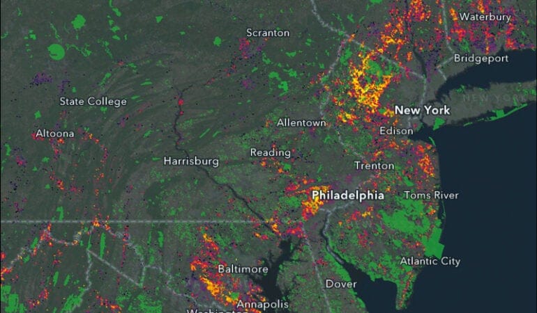
Imagen: El Centro de Soluciones Geoespaciales (CGS) ampliará el acceso a sistemas de información geográfica (SIG), detección remota y otras herramientas que pueden ayudar a tomar decisiones sobre gestión territorial e hídrica. Este mapa del CGS combina datos sociales y medioambientales para destacar entornos de los cuales dependen especies en riesgo, o que están bajo presión por el desarrollo y adyacentes a áreas protegidas existentes (en verde). Crédito: CGS.
Geospatial Technology
Lincoln Institute of Land Policy Launches Center for Geospatial Solutions
By Will Jason, October 29, 2020
SHARE
The Lincoln Institute of Land Policy today launched a new enterprise to expand the use of advanced technology for land and water conservation—The Center for Geospatial Solutions (CGS). The center will give people and organizations the tools they need to manage land and water resources with precision, at the scale required to confront pressing challenges such as climate change, loss of habitat, and water scarcity.
The center will provide data, conduct analysis, and perform specialized consulting services that enable organizations of all sizes in the nonprofit, public, and private sectors to deploy geographic information systems (GIS), remote sensing, and other geospatial technologies. The center will help practitioners to overcome barriers such as a lack of staffing, resources, or expertise, which have hindered the adoption of geospatial technology, especially in the nonprofit sector.
“If land and water managers, conservationists, and governments are to meet rapidly accelerating social, economic, and environmental challenges, including climate change, they need to work together at larger scales and make use of every possible tool,” said Anne Scott, executive director for the Center for Geospatial Solutions. “The Center for Geospatial Solutions will enhance collective access to better data and analysis, so that practitioners and decisionmakers can act collaboratively on the best information available.”
The center will deliver services directly to nonprofit organizations, foundations, governments, and businesses, and will also work with funders to guide and administer grants. The center will also use the resources and expertise of the Lincoln Institute, which is organized around the achievement of six goals: sustainably managed land and water resources, low-carbon, climate-resilient communities and regions, efficient and equitable tax systems, reduced poverty and spatial inequality, fiscally healthy communities and regions, and functional land markets and reduced informality.
“My wife, Laura, and I developed Esri to help people make better decisions for our world, and that is what the Center for Geospatial Solutions is accomplishing,” said Jack Dangermond, President and CEO of Environmental Systems Research Institute (Esri). “The Center for Geospatial Solutions will move the global environmental field over the next decade to meet goals set forth by scientists to save and restore our planet. The center’s combination of partnerships, shared resources, advanced data science and analysis fills an important niche to bring geospatial technology solutions to environmental organizations worldwide.”
The center will prioritize access to technology for people and communities that have been historically marginalized, governments in the developing world, under-resourced nonprofit organizations, startups, and businesses operating in developing or restricted economies. The center will build customized tools that can be tailored to fit the size and capacity of any organization.
“These are unprecedented times, which require broad vision combined with the practical implementation of innovative solutions,” said Breece Robertson, director of partnerships and strategy for the Center for Geospatial Solutions. “We can’t address global challenges like climate change and inequity without access to data, science and technologies that enable everyone to act effectively.”
The potential for geospatial technology to improve conservation is well demonstrated. In one powerful application, regional planners in Tucson, Arizona, worked with nonprofit partners, including the Lincoln Institute’s Babbitt Center for Land and Water Policy, to map the tree canopy, surface temperatures, and other data to help communities to better-manage stormwater, and to prioritize where to plant trees. In another case, Denver’s regional planning agency is using high-resolution maps to classify land cover into eight categories for a wide range of possible uses, including to understand habitat connectivity and quality to guide investment in green infrastructure.
In addition to advancing land and water conservation, geospatial technology can inform decisions in urban contexts. Its applications include analyzing cities’ carbon footprints, exploring the conservation potential of brownfield sites, revealing local variations in air quality, and mapping parks, open spaces, and urban corridors for wildlife.
“Some organizations are already using geospatial technology to understand what is happening on the ground with greater and greater precision,” said Jeffrey Allenby, director of geospatial technology for the Center for Geospatial Solutions. “The center will bring this capability to organizations of all sizes and scales by building customized tools that are easy to use for all staff, even those with no background or training in technology.”
“The center builds on the Lincoln Institute’s long track record of pioneering ideas that have transformed land policy,” Lincoln Institute President and CEO George W. “Mac” McCarthy wrote in an essay in Land Lines, the magazine of the Lincoln Institute. “The Center for Geospatial Solutions represents another transformational idea—by making land, water, and mapping technology universal, we can enable people and organizations to collaborate and achieve impact that is orders-of-magnitude greater than what they can accomplish today. Like lifting a fog, applying geospatial technology will enable anyone to see what is happening anywhere on the Earth. It will make the planet feel that much smaller, and the solutions to humanity’s toughest problems that much easier to grasp.”
Anne brings leadership experience in public and community health and international development, and she is particularly passionate about achieving cost-effective outcomes that can be replicated and scaled. She has lived and worked in Asia, Africa, and the Middle East on the implementation and evaluation of large-scale health and environmental programs funded by the U.S. and European governments, and philanthropic foundations. Anne has held executive positions at the Children’s Investment Fund Foundation in London, the Charlottesville (Virginia) Area Community Foundation and, most recently, Boston-based Pathfinder International. She is a prior board chair of the Chesapeake Conservancy. Anne has a Ph.D. in medical anthropology and an MBA in finance, as well as post-doctoral qualifications in science and diplomacy, and health and child survival.
Jeff brings a wealth of experience developing systems-focused solutions at the intersection of technology and the natural world. Prior to joining the Lincoln Institute, Jeff was the director of conservation technology at the Chesapeake Conservancy and cofounder of the Conservancy’s Conservation Innovation Center, building it from scratch into a globally recognized pioneer in the application of technology to improve environmental decision making in the Chesapeake Bay and across the world. Jeff worked previously for the University of Maryland Center for Environmental Science and the Maryland Department of Natural Resources on projects to support local climate change adaptation. Jeff has a M.E.M. and a certificate in geospatial analysis from Duke University and a B.S. from the University of Richmond. Jeff also serves as a member of the advisory board for the Internet of Water.
Breece has more than 18 years of experience leading collaborative and strategic initiatives that leverage data-driven platforms, GIS, research, and planning for the park and conservation fields. Breece combines geospatial technology and storytelling to inspire, activate, educate, and engage. During her career at The Trust for Public Land, she led geospatial innovations that supported the protection of 3,000+ places, over 2+ million acres of land, provided park access to over 9 million people, and achieved $74 billion in voter-approved funding for parks and conservation. She is a skilled leader, collaborator, implementer, and creative visionary with a legacy of building award-winning teams and community-driven GIS approaches for strategic conservation and park creation. Esri, the world’s leader in geographic information system (GIS) technology, twice has honored Robertson for innovation in helping communities meet park and conservation goals. In 2006, she was awarded the Esri Special Achievement in GIS award and in 2012, the “Making a Difference” award – a prestigious presidential award.
About the Lincoln Institute of Land Policy
The Lincoln Institute of Land Policy seeks to improve quality of life through the effective use, taxation, and stewardship of land. A nonprofit private operating foundation whose origins date to 1946, the Lincoln Institute researches and recommends creative approaches to land as a solution to economic, social, and environmental challenges. Through education, training, publications, and events, we integrate theory and practice to inform public policy decisions worldwide.
Will Jason is director of communications at the Lincoln Institute.
In the 1980s, not long after China had opened up to global trade and commerce, the nation’s farmland began succumbing to rapid urbanization. The explosive growth of cities consumed an estimated 7 million to 12 million acres of prime farmland from 1987 to 1995. This pattern led to dramatic changes in the landscape and grave concerns about food security. Aware that no farms meant no food for the country’s growing population—and just a few decades removed from a devastating famine that had cost the lives of 20 million to 50 million people between 1958 and 1961—the central government enacted regulations requiring those who converted farmland for other uses to ensure the protection of the same amount of farmland elsewhere.
China’s Ministry of Land and Resources tried heroically to meet these zero net loss mandates. But it was impossible to monitor land quality and local land exchange decisions, especially with last-generation management systems like limited data, paper records, and low-resolution maps. Urbanization continued apace, swallowing an estimated 82 million acres of farmland between 2001 and 2013. In most cases, the rich farmlands around growing cities were “replaced” with less productive woodlands and grasslands. To get higher yields from less fertile land, farmers had to adopt more intensive cultivation practices, relying on chemical fertilizers, pesticides, and irrigation. These technical solutions maintained food security, but at a high cost, including the depletion of aquifers and contamination of soil.
China is now a net importer of grains and future production hinges on finding new sources of water for irrigation. Concerns are growing about food security once more, but something else is changing in China: the land and resources agency—now called the Ministry of Natural Resources—is modernizing the system it uses to monitor and enforce the farmland preservation policy. This includes adopting geospatial data from satellite imagery and other remote sensing to map and evaluate the quality of reclaimed land. It also includes monitoring urban frontiers to better guide development decisions.
Recent improvements in the quality of satellite imagery and computer analysis methods are making it possible to monitor China’s farmland preservation efforts with increasing precision. These improvements also hold great promise for land and water conservation around the globe. This fall, the Lincoln Institute is taking a major step to expand the accessibility and use of such cutting-edge technology by launching the Center for Geospatial Solutions (CGS).
CGS is a new hub of data, expertise, and services for people and organizations across the public, private, and nonprofit sectors working to conserve land and water resources. It will expand access to geographic information systems (GIS), remote sensing, and other tools that can inform decisions about land and water management. Although these tools have existed for decades, many organizations lack the data, equipment, staff, or expertise to implement them, limiting their ability to achieve their goals and to collaborate with others at large scales. The center will focus on opening access to cutting-edge technology for historically oppressed or marginalized people and communities; governments in low- to middle-income countries, regions, or states; nonprofit organizations with limited resources; and startup businesses, or businesses operating in developing or restricted economies.
We’re launching this effort because we know that sweeping reforms like those China implemented to preserve farmland are just the first step toward an intended outcome. To succeed, such policies must be followed by the less glamorous work of persistent enforcement and monitoring, with adjustments to the rules in response to lessons learned. In addition, if policy makers hope to manage land policy at the national or international level, they need access to the best possible data and precision tools to track and respond to what is happening locally. CGS, led by staff members with deep expertise in mapping technologies, organizational development, public health, and conservation, will provide data, conduct analysis, and build customized tools to respond to increasing demand from organizations of all sizes, with all levels of technical capacity.
CGS builds on the Lincoln Institute’s long track record of pioneering ideas that have transformed land policy at national and global levels. Beginning in the 1970s, the Lincoln Institute played a leading role in developing computerized property assessment. This revolutionized how local governments around the world administered the property tax—the most important component of local public revenues in most places. In the early 1980s, the Lincoln Institute convened some 40 land trusts to mobilize efforts to conserve private land in the United States to complement public land conservation. By expanding the scope and use of conservation easements and advocating successfully for state and federal tax breaks for private land conservation, the coalition, which became the Land Trust Alliance, has since helped to protect more than 56 million acres of private land—equal to the land area of Minnesota. And in 2014, we launched the International Land Conservation Network, which connects civic and private land conservation organizations and people around the globe, and has spawned major conservation initiatives on several continents.
With the launch of CGS, we are prepared to apply our expertise to the work of supporting and amplifying today’s bold land-based initiatives. Earlier this year, for example, the Campaign for Nature launched an effort to protect 30 percent of the planet’s land and oceans by 2030. The “30 by 30 Campaign” seeks to address climate change, support a growing global population, and prevent mass extinctions by protecting critical natural resources and ecosystems, and monitoring and managing their protection in perpetuity. This colossal effort can learn from farmland protection efforts in China and other bold efforts to manage land and resources at national or global levels, and it will benefit from the kind of tools and analysis CGS brings to the table.
An important first question is whether we can leverage the traumas of 2020—a pandemic, devastating wildfires in Australia and the United States, the increasing frequency and severity of weather-related calamities—to forge the political will to take meaningful global action. Can we convince global politicians and voters that the climate crisis or mass extinctions threaten human survival and require the type of coordinated global action sparked by the pandemic? Second, can we sharpen the global goal of 30 by 30 to motivate more specific (and practical) actions at lower levels of geography to avoid unintended consequences? While 30 by 30 is a handy slogan, the 30 percent of lands and oceans the campaign chooses to protect will have direct bearing on whether we can reverse the climate crisis or avert mass extinctions.
We will need to determine which land and other resources to protect, which to protect first, and how to do it. We will need to monitor local actors to make sure their actions are consistent with global goals and strategies. And we’ll need to find ways to hold key actors accountable for meeting critical benchmarks. Finally, once we’ve identified the specific ecosystems we want to protect, we will need legal mechanisms to protect them and means to monitor protection and stewardship in perpetuity. It will require thousands of people equipped with the tools and training to monitor and enforce legal agreements and the authority to do so.
The Lincoln Institute can contribute to this bold global effort by helping the Campaign determine which land and other resources to protect first, how to monitor and manage that protection, and, with the help of ILCN, how to navigate the relevant legal mechanisms across different countries with different legal systems. In parallel efforts, the Lincoln Institute is building distance learning curricula to train local government officials and practitioners to use new land and water management tools and approaches more effectively. CGS can decentralize decision making by providing tools and training that can be deployed locally to support global goals. By making mapping technology universally available, we can enable people and organizations to collaborate and achieve impact in land and water conservation that is orders of magnitude greater than what they can accomplish alone.
The Center for Geospatial Solutions exists to bring new clarity and insight to the business of global land conservation, increasing access to data in the name of building a more sustainable future. Like lifting a fog, applying geospatial technology will enable anyone to see what is happening anywhere on the Earth. It will make the planet feel that much smaller, and the solutions to humanity’s toughest problems that much easier to grasp.
Image: The Center for Geospatial Solutions (CGS) will expand access to geographic information systems (GIS), remote sensing, and other tools that can inform decisions about land and water management. This CGS map combines social and environmental data to highlight landscapes that are relied on by at-risk species, facing development pressures, and adjacent to existing protected areas (shown in green). Credit: CGS.
Graduate Student Fellowships
2021 C. Lowell Harriss Dissertation Fellowship Program
The Lincoln Institute's C. Lowell Harriss Dissertation Fellowship Program assists PhD students, primarily at U.S. universities, whose research complements the Institute's interests in land and tax policy. The program provides an important link between the Institute's educational mission and its research objectives by supporting scholars early in their careers.
The onset of the pandemic led the International Land Conservation Network (ILCN) to recast plans for a global conservation congress earlier this year, shifting from an in-person gathering for 300 people in Barcelona to a series of virtual webinars. Like many organizations, ILCN saw a surprising benefit emerge from this unexpected change of plans: its webinar series received more than 1,100 registrations from conservation practitioners in 83 countries, and targeted sharing of series recordings in countries including China has expanded that reach into the thousands.
That experience led ILCN to recognize an opportunity: combining targeted, regional outreach with the global reach enabled by virtual tools and strategies could help strengthen engagement throughout the land conservation community. This fall, the organization appointed regional representatives on six continents. “By bringing on this core group of experienced regional representatives, we’re hoping to encourage a more robust exchange of expertise and ideas,” said Chandni Navalkha, program manager for Land Conservation at the Lincoln Institute.
The newly appointed representatives will utilize their deep experience in private and civic land conservation to build upon existing relationships in each region — through meetings and conversations held in person or virtually as the evolving global context allows — and forge new connections with leading practitioners and experts. They will bring their expertise to the broader ILCN community through webinars, newsletter articles, and other channels and, in turn, share resources, news, and strategies related to private and civic land conservation in other geographies with key stakeholders in the region they are representing. In China, for example, regional representative Shenmin Liu will join the steering committee of the China Civic Land Conservation Alliance (CCLCA), where she will share the evolving strategies and policies through which civic conservation efforts will be included in the planning for a new Chinese national park system.
ILCN works across six continents to protect and steward landscapes. Credit: International Land Conservation Network.
“We are honored to have recruited such a diverse and accomplished group of conservationists to serve as our regional ambassadors,” noted Jim Levitt, director of the ILCN. In early October, Levitt hosted a virtual meet and greet that provided a forum for the representatives to introduce themselves to each other and to members of the ILCN network from around the world. The representatives each spoke for a few minutes about their work, as well as the challenges and opportunities ahead:
Europe: Tilmann Disselhoff. Disselhoff manages the European Land Conservation Network (ELCN), an EU-wide network of organizations active in private land conservation that “wouldn’t have been possible without the help of ILCN,” he said. Disselhoff spoke about the power of collaboration and about plans for expanding the work of ELCN.
Australasia: Cecilia Riebl. A policy advisor for Australia’s Trust for Nature, Riebl spoke about obstacles and progress in the region: “This sector has a profound and compelling cause: it is absolutely critical to addressing the global biodiversity crisis, and increasingly will need to do this in dynamic ways, by introducing new actors to conservation and finding creative ways to finance it.”
Latin America: Hernan Mladinic. Mladinic, of Chile, has worked in conservation for more than 30 years and recently concluded a 10-year stint as executive director of Tompkins Conservation, which promotes landscape-scale conservation in South America. In the context of COVID and climate change, Mladinic said, “conservation will have to strategically link social, environmental, and economic issues.”
Asia: Shenmin Liu. A research analyst at the Lincoln Institute who grew up in Beijing, Liu described China’s conservation efforts and the tension between conservation and economic growth in developing countries in Asia. Liu sees a “huge need for multidirectional knowledge exchange” and will work with regional NGOs ahead of the meeting of the Conference of the Parties (COP-15) of the Convention on Biological Diversity (CBD)in Kunming, China, in May 2021.
North America: Shawn Johnson. As managing director of the Center for Natural Resources and Environmental Policy at the University of Montana, Johnson was instrumental in helping to launch the Lincoln Institute’s Large Landscape Peer Learning Initiative. “We think about land conservation as something we do on the side,” he said. “But conservation is critical to the health and well being of our society . . . how do we create the connections that will help us heal as we move forward?”
Africa: Kiragu Mwangi. Mwangi, a senior capacity development manager for BirdLife International who is currently based in the United Kingdom, grew up in Kenya and says stronger collaboration is needed between land conservation groups in Africa and elsewhere. “Partnerships are made even more rich when we collaborate and partner with people from different backgrounds,” he said, “for it is in diversity that we draw on the great wealth of knowledge and experiences to help achieve greater impacts with our work.”
Citing the urgency of advancing innovation in land conservation in light of the upcoming Convention on Biological Diversity COP-15 meeting in China, as well as the growing momentum behind the global campaign to protect 30 percent of the earth’s surface by 2030 (30×30), Levitt said the virtual gathering, and the promise of an increasingly connected and collaborative approach to conservation, gave him hope. “It’s not only humbling to be in this group, I hope it’s also emboldening,” Levitt said at the conclusion of the meet and greet. “To know there is a group of people all over the world with the courage and strength and intelligence to prepare a world our great-grandchildren can enjoy . . . . The more connections we make now, the more connections we will make going forward.”
Katharine Wroth is the editor of Land Lines.
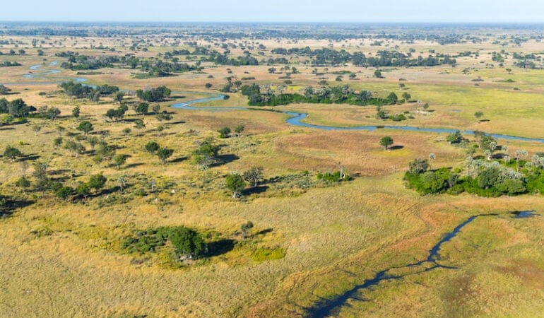
Photograph: Aerial View over Okavango Delta in Botswana. Credit: Gfed/Getty Images Plus.
Fernando Lloveras San Miguel of the Conservation Trust of Puerto Rico Wins the Kingsbury Browne Fellowship and Conservation Leadership Award
October 12, 2020
SHARE
Fernando Lloveras San Miguel, executive director of the Conservation Trust of Puerto Rico, has been named the new Kingsbury Browne Fellow at the Lincoln Institute of Land Policy and the recipient of the Kingsbury Browne Conservation Leadership Award from the Land Trust Alliance (LTA).
For the past 17 years, Lloveras has led the Trust, which manages and protects Puerto Rico’s natural areas, runs habitat and species restoration initiatives, and implements coordinated public awareness campaigns, among other activities. Under his leadership, the Trust has received the Seal of the Land Trust Accreditation Commission and been accepted into the International Union for Conservation of Nature, becoming the only organization in Puerto Rico to receive this distinction. Since 2012, Lloveras has also served as president of Para la Naturaleza, a unit of the Trust which aims to protect 33 percent of natural ecosystems in Puerto Rico by 2033. He served on the board of the Land Trust Alliance from 2011 to 2020 and will serve on the board of the National Trust for Historic Preservation through November 2020.
Prior to joining the Conservation Trust of Puerto Rico, Lloveras cofounded Microjuris.com, which provides digital legal and legislative information and tools to users in Puerto Rico, Chile, Argentina, and Venezuela. He holds a B.A. in Economics from Dartmouth College, an M.P.P. from the Harvard Kennedy School of Government, and a J.D. from the University of Puerto Rico.
“Fernando Lloveras is both a great practitioner of land conservation in Puerto Rico and an outstanding international ambassador for the idea that land and biodiversity conservation is a global enterprise to which we can all contribute,” said Jim Levitt, who leads the Lincoln Institute of Land Policy’s land conservation efforts. “He is personable, very bright, and has a deep passion for the land. We are proud to have the chance to work with him over the coming year as the new Kingsbury Browne Fellow at the Lincoln Institute of Land Policy.”
Fernando Lloveras San Miguel. Credit: Para La Naturaleza.
The Kingsbury Browne fellowship and award, given since 2006, are named for Kingsbury Browne, a Boston tax lawyer and conservationist who served as a Lincoln Fellow in 1980 and helped to form the LTA in 1982. Lloveras San Miguel was officially recognized at Rally 2020, LTA’s annual gathering of land conservation professionals, which this year attracted over 3,700 virtual attendees. During 2020–2021, Lloveras will engage in research, writing, and mentoring at the Lincoln Institute.
Previous recipients of the fellowship include Jane Difley, who led the society for the Protection of New Hampshire Forests for 23 years; Michael Whitfield, executive director of the Heart of the Rockies Initiative, who has built partnerships among landowners, civic leaders, government officials, and scientists to protect iconic landscapes in the Rocky Mountain West; Will Rogers, head of The Trust for Public Land; David Hartwell, an environmental leader who has helped mobilize billions of dollars for conservation projects across Minnesota; Steve Small, a legal pioneer who paved the way to make conservation easements tax-deductible in the U.S.; Jean Hocker, a former president of the LTA and longtime board member at the Lincoln Institute; Larry Kueter, a Denver attorney specializing in agricultural and ranchland easements in the West; Peter Stein, managing director of Lyme Timber Company; Audrey C. Rust, president emeritus of the Peninsula Open Space Trust based in Palo Alto, California; Jay Espy, executive director of the Elmina B. Sewall Foundation; Jamie Williams, president of The Wilderness Society; Laurie A. Wayburn, cofounder of the Pacific Forest Trust; Mark Ackelson, president of the Iowa Natural Heritage Foundation; and Darby Bradley, president of the Vermont Land Trust.
About the Lincoln Institute
The Lincoln Institute of Land Policy seeks to improve quality of life through the effective use, taxation, and stewardship of land. A nonprofit private operating foundation whose origins date to 1946, the Lincoln Institute researches and recommends creative approaches to land as a solution to economic, social, and environmental challenges. Through education, training, publications, and events, we integrate theory and practice to inform public policy decisions worldwide.
About the Land Trust Alliance
Founded in 1982, the Land Trust Alliance is a national land conservation organization that works to save the places people need and love by strengthening land conservation across America. The Alliance represents 1,000 member land trusts supported by more than 200,000 volunteers and 4.6 million members nationwide. The Alliance is based in Washington, D.C., and operates several regional offices. More information about the Alliance is available at www.landtrustalliance.org.
2020 C. Lowell Harriss Dissertation Fellowship Program
Submission Deadline:
March 16, 2020 at 6:00 PM
SHARE
The Lincoln Institute's C. Lowell Harriss Dissertation Fellowship Program assists Ph.D. students, primarily at U.S. universities, whose research complements the Institute's interests in land and tax policy. The program provides an important link between the Institute's educational mission and its research objectives by supporting scholars early in their careers.