Grid Locked: How Land Use Battles Are Hindering the Clean Energy Transition
By Anthony Flint, June 12, 2023
SHARE
One emerging consensus to combat climate change is increasingly clear: electrify everything, and make that power come from renewable sources, like wind, solar, and hydro power. Removing fossil fuels from electricity generation can be surprisingly smooth, as clean power facilities have rapidly become more cost-efficient. Renewables are currently 20 percent of US power generation and steadily growing.
But there’s a sprawling and daunting land use task that is necessary to make that clean energy transition happen: not only the siting of solar arrays and wind farms, but the construction and improvement of transmission lines and substations and pipelines, across thousands of acres of land.
Researchers at Princeton University have estimated that if manufacturing capacity for turbines and photovoltaics continues to ratchet up as it has been for the last several years, up to 400,000 square miles will be needed in the US to harvest wind energy alone. That means much more visible renewable energy infrastructure on hilltops, in suburban neighborhoods, and in what may feel like people’s backyards.
Battles over the siting of wind and solar installations, and opposition to the key upgrades and expansion of the grid that will allow clean power to plug in, are occurring on a state-by-state basis, in the absence of federal authority or oversight. In many cases, renewable energy facilities have been cleared through the permitting process to start operating, but remain in limbo because they can’t plug in to the existing, antiquated grid.
Power lines in California. Credit: pgiam via E+/Getty Images.
A crazy quilt of local land use regulations—including bylaws restricting solar fields and wind farms—has amplified the voices of opposition from neighbors and organized groups, including, in what many climate advocates consider a profound irony of the times, some environmental organizations. In addition, land use conflicts are hindering another critical component of the clean energy transition: the mining of metals such as lithium to make high-capacity rechargeable batteries, for electric vehicles and storing power from renewable sources when the sun doesn’t shine or the wind doesn’t blow (see sidebar).
Those targeting net-zero emissions by mid-century hoped for a high-level wave of renewable energy that would transform the way everyone gets their power. Instead, there are standoffs and bottlenecks, at the state and local level, as the execution of this extraordinary transition gets bogged down, literally, on the ground.
“I would agree things aren’t going well right now—though I would suggest that we also have way more shots on goal than in previous years, so there are more stories of projects getting blocked because there are just more project proposals,” said Sarah Banas Mills, senior project manager at the Graham Sustainability Institute and lecturer at the School for Environment and Sustainability, University of Michigan.
As frustration mounts at what many see as a fumbling of the ball at a key moment in the fight against climate change, Mills, who has been tracking battles over renewable energy all over the US and coauthored a paper on the topic, says a more nuanced analysis is required about each and every site, now that installations are ramping up. Wind projects in places with more people or higher scenic amenities are more likely to be opposed; neighbors may also be more likely to balk at large solar arrays on farmland, which many clean-energy advocates thought would be an easier sell.
“Renewables present one of the biggest economic opportunities rural communities have seen in decades,” she said. “But with all opportunities, there are trade-offs. That we have so many communities saying no suggests to me that in many places communities are finding that the positives—economic benefits—don’t outweigh the negatives. Changes may need to be made to project characteristics, like size, location within the community, and distribution of economic benefits . . . to get more communities to ‘yes.’”
It wasn’t always this way. In the past, there was little to no veto power exercised at the local level, as industrialization advanced and critical infrastructure was deemed necessary, whether canals, railroads, and telegraph lines in the 19th century, or the interstate highway system in the 1950s.
A common thread for infrastructure is the intensive use of land, which is necessary to complete networks and distribute benefits across large expanses. This was especially true in the development of the grid. Power plants were built at whatever location was required, whether near a coal mine or on a river. Then, a decentralized but highly connected system of substations, transformers, and transmission and distribution lines got the power to the end user—homes and businesses. The flow of power is from point to point and as it happens, since large amounts of electricity are not stored; the power is used as it is produced, and vice versa.
Although the construction, organization, and regulation of the grid started out in a patchwork state-by-state and regional framework, the federal government established oversight with the Federal Power Act of 1920, which Congress passed to coordinate the development of hydroelectric projects such as the Hoover Dam. Major new agencies like the Tennessee Valley Authority, established in 1933, helped create a sense of intention and purpose; bringing electricity to rural areas was part of a national mobilization in economic development during the Great Depression (and, also intentionally, a fountainhead of jobs). Among other federal agencies, what is now known as the Federal Energy Regulatory Commission (FERC) took the lead in managing power generation and the grid, although generally oversight of utilities, and the prices they charge in particular, remains a state responsibility.
A photo by Dorothea Lange of electrification work in California’s San Joaquin Valley in 1938. Credit: Library of Congress, Prints & Photographs Division, FSA/OWI Collection, LC-DIG-fsa-8b32664.
In terms of the extraordinary accomplishment of the grid, the ultimate result of planning and coordination is the familiar landscape of today: 160,000 miles of high-voltage power lines draped on shiny metal stanchions up to 200 feet tall, with forest and brush cleared away underneath, crisscrossing the countryside, whisking electricity generated by 7,300 power plants to nearly 150 million customers across the US, according to the US Energy Information Administration (EIA). The North American grid—three grids, technically, called the Eastern, Western, and Texas Interconnect—is completed by millions of miles of low-voltage power lines and distribution transformers.
To date, most electricity is produced using conventional sources such as natural gas, oil, coal, and nuclear. But at least 20 percent of the nation’s power is now generated by renewable energy facilities—wind, solar, hydroelectric, biomass, geothermal—and that proportion is growing, as coal-fired power plants, for example, are steadily phased out. Over the past decade, 290 coal-fired plants were decommissioned in the US, leaving 224 in operation.
The Biden administration has pledged to eliminate fossil fuels as a form of energy generation in the US by 2035, setting the goal of 80 percent carbon-free electricity by 2030. Wind, solar, and hydroelectric power have been the fastest-growing segment of the energy sector, and will be further fueled by some $370 billion in funding under the Inflation Reduction Act. Wind and solar projects, steadily improving in their technology and efficiency, are ready to roll.
But therein lies the current land use challenge—not only in the siting of renewable energy installations, but also in the all-important upgrade to the grid to carry and distribute all that clean power. On both fronts, the development of renewable energy has been stymied in recent years.
The U.S. power grid comprises three sections: the Eastern, Western, and Texas (ERCOT) Interconnects. The circles represent the system’s 66 balancing authorities, which ensure the balance between supply and demand. Credit: US Energy Information Administration.
Opposition to offshore wind farms, notably the Cape Wind project off Cape Cod, was perhaps the first and most infamous example of affluent homeowners objecting to clean-energy infrastructure because they claimed it spoiled the view. But wind farms on land, whether atop ridges or on farmland, have also ignited fierce opposition, even in remote areas.
In Northern California, Shasta County supervisors rejected a proposal by Connect Wind/Fountain Wind for 48 turbines on rural land after hearing concerns about impacts on wildlife habitat, Indigenous lands, and even whether the turbines would interfere with fighting wildfires from the air. A local ordinance passed shortly afterward banning large wind projects outright. The California Energy Commission is allowing the developers a second chance under a provision of Assembly Bill 205, which can override local veto power over clean energy projects.
In Iowa, a judge ordered developers to dismantle three 450-foot turbines on farmland after neighboring landowners complained about the noise they made. The victorious opponents, who successfully argued that the zoning board shouldn’t have issued the permits, hope their battle “will empower other rural landowners and small towns to take on wind,” according to the Des Moines Register.
A typical concern as well is the danger posed by wind turbines to birds—although pesticides, buildings, and housecats kill many times more birds than the slowly rotating blades, and clean-tech researchers, using artificial intelligence, have come up with ways to keep birds away anyway.
Solar installations have not fared much better. While more than 2,500 solar farms are up and running in the United States, solar projects are increasingly running into blockades, in Indiana, Ohio, Virginia, and elsewhere. Neighbors often get in an uproar when they see how large, visible, and land-intensive some of the solar arrays are, describing them in alarming fashion, as in one battle over a Midwest proposal, as filling up thousands of football fields with shiny, deep blue panels.
Solar array in western Massachusetts. Credit: Jerry and Marcy Monkman/EcoPhotography.
Researchers in a 2021 Michigan study found that despite readily acknowledged benefits such as economic development, tax payments, and compensation for the landowner and community, “projects have increasingly faced local resistance . . . [due to] aesthetics, noise, and negative impacts to rural and Tribal culture, values, and community energy sovereignty, along with . . . risk to wildlife, productive farmland, biodiversity, and human health.” Additional perceived risks included lowered home and property values, increased electricity rates, impacts to tourism, and the toxicity of materials used in construction and operation, the study says.
A team at MIT studied 53 American renewable energy projects that were paused, delayed, or canceled between 2008 and 2021 in 28 states because of local opposition. The researchers identified seven common drivers of conflict: environmental impact; financial viability; quality of public engagement; Tribal rights; health and safety concerns; and concerns related to land and property values.
“We found overwhelming evidence to suggest that federal, state, and local regulators need to rethink the design and operation of their facility siting processes,” the researchers conclude. “A fast and fair transition to renewable energy will not be achieved in the US if policymakers and energy developers do not anticipate and respond proactively to the full array of sources of local opposition.”
High-profile standoffs have the effect of scaring off partners worried about bad publicity. In Queensland, Australia, the tech company Apple withdrew from an agreement to buy power from a proposed 80-turbine windfarm on nearly 2,000 acres, a project the World Wildlife Fund (WWF) had criticized for threatening koalas, wallabies, and red goshawks. A WWF spokesman applauded the move, saying it demonstrated “leadership and a commitment to renewables that are good for climate and nature.”
Opposition to transmission lines and the upgrades and expansion of the grid that are necessary to handle new clean power has been perhaps the most strenuous of all—leaving renewable energy installations that have already been built or permitted to remain in limbo, an untenable scenario for green-tech companies and investors.
A four-year legal battle over a 145-mile transmission line that would carry hydroelectric power from Quebec to Massachusetts has been representative of the bare-knuckle brawling over land use. Conservation groups said the pipeline threatened wilderness areas in Maine, where most of the line would be constructed, prompting a statewide vote against the project, though it had already been permitted. A judge recently ruled that construction could resume.
Proponents complained that the opposition had been financed and motivated by a rival natural gas utility seeking to block competition. Joseph Curtatone, president of the Northeast Clean Energy Council, said he hoped the court decision “marks an end to the self-interested, corporate-funded attempts to sabotage this project.” Building the project as planned, he said, would remove more than 3 million metric tons of carbon annually and provide $200 million in desperately needed upgrades to the electric grid.
“This is essential work in our effort to electrify everything in order to avoid the worst effects of climate change. Without grid upgrades we can’t deliver power to heat pumps and electric vehicles. These are the kinds of big leaps we need to take after decades of minimal progress on climate action,” he said. “If we’re fighting tooth-and-nail over removing 3 million tons of CO2 with lower-cost energy, we’re never going to reach net zero.”
In the book Superpower, the author Russell Gold chronicled the ultimately futile attempt by Houston businessman Michael Skelly to get approval for a transmission line to connect windfarms in Oklahoma to the grid in Tennessee, which became emblematic of community opposition paired with politics. But the same problem keeps recurring. It took 18 years before a 732-mile transmission line was approved by federal authorities to carry clean power from the proposed 700-turbine TransWest wind farm on ranchland in Wyoming to homes and businesses in California. The interstate project required multiple approvals under the National Environmental Protection Act (NEPA), with detailed examination of impacts on flora and fauna, including the sagebrush grouse.
Wind turbines in Washington state. Credit: Ryan J Lane via E+/Getty Images.
The objections to green infrastructure have evoked past battles over endangered species, sacred sites, and otherwise culturally valuable land. The Greenlink West project, a 470-mile transmission line through Nevada, is under fire because it might disturb woolly mammoth tusk fossils.
The irony is not lost on many that environmental laws passed in the 1970s to combat rampant pollution are now being used to fight renewable energy projects that will curb climate change. Environmental litigation is threatening a wide range of environmentally advantageous initiatives across the country, from dense housing to bike lanes to congestion pricing.
“I’m an environmentalist, which means I’ve got some practice in saying no. It’s what we do,” wrote Bill McKibben in an essay for Mother Jones titled, “Yes in Our Backyards.” McKibben’s decades of activism include successfully fighting the Keystone XL fossil-fuel pipeline. “But we’re at a hinge moment now, when solving our biggest problems—environmental but also social—means we need to say yes to some things. . . . One way may be to back up a little and think of the slightly longer term.”
Without any sense of a grand plan or rationale, and environmentalists divided—one camp saying impacts on the environment must always be considered, the other that there will be no functioning wildlife habitats or thriving species if climate change isn’t curtailed—renewable energy projects are increasingly being viewed as what Harvard professor Alan Altshuler called LULUs: “locally unwanted land uses,” like prisons or landfills.
An array of solutions for overcoming this impasse has emerged recently, including legislation introduced just this year. At least three steps are needed to adequately and effectively deploy clean energy infrastructure, says Patrick Welch, an analyst in the Climate Strategies group at the Lincoln Institute of Land Policy: federal-level permitting reform, local regulatory changes, and more strategic and creative planning.
“In many instances, there are genuine issues regarding the proposed siting of new solar, wind, and hydro projects—whether that is related to stormwater runoff issues, other impacts on important ecosystems, or new land grabs on Indigenous lands,” Welch said. “We need to be more strategic and creative. Things like co-locating solar on parking lots and rooftops or interstate rights of way, rather than clearcutting forests, are good solutions.”
The Nature Conservancy’s Site Renewables Right initiative, which identifies suitable sites for wind and solar energy by mapping factors including environmental impact and agricultural production, is a good example of trying to find workable solutions, he said; another is Baltimore County’s study on solar siting, which identified nearly 34,000 acres of potential optimal solar sites on rooftops, parking lots, and degraded lands.
Solar installer in Lowell, Massachusetts. Credit: Jerry and Marcy Monkman/EcoPhotography.
But even with more appropriate siting, Welch said, permitting and local land use regulations can get in the way. “Both sides of the aisle have known for decades that NEPA and the associated permitting spiderwebs are responsible for long, unnecessary delays. Now, the climate crisis has brought new urgency to that conversation. Local regulations must allow for the appropriate siting of renewable energy infrastructure, too.”
Federal coordination—harkening back to the more intentional establishment of infrastructure in the first half of the 20th century—has seemed to many the obvious first step. This spring, US Senator Sheldon Whitehouse (D-RI) and US Representative Mike Quigley (D-IL) introduced the Streamlining Interstate Transmission of Electricity (SITE) Act, which would establish a new federal siting authority at the Federal Energy Regulatory Commission to ease the process of constructing long-range, high-voltage transmission lines.
“If we don’t build more long-range transmission lines, much of the low-cost clean energy that is coming online will simply not be able to get to the homes and businesses that need it,” Whitehouse said when unveiling the bill. The goal is better reliability, an upgrade of the nation’s creaky grid infrastructure, and lower emissions while “responsibly balancing local needs and preferences,” he said.
There is action at the state and regional scale as well. After criticism that state regulatory authorities have been dragging their feet on the clean energy transition, Massachusetts Governor Maura Healey appointed climate-savvy commissioners to the state Department of Public Utilities, and established two new commissions, one to review clean energy siting and permitting, and another to coordinate offshore wind development.
In Washington State, Governor Jay Inslee recently signed a bill requiring longer-term planning by utilities and allowing bigger transmission projects to go through the state’s streamlined siting process. The Bonneville Power Administration (BPA), which manages hydropower from 31 federal dams in the Northwest, has proposed some upgrades to its system, which, if completed, will help increase transmission capacity.
The electricity market is structured differently in the Pacific Northwest than in California and other states, making coordination and planning that much more difficult, said Emily Moore, director of the Climate and Energy program at the Sightline Institute. Washington and Oregon have assertive climate action plans to shift to clean energy, but even if all utilities agreed to switch tomorrow, the grid couldn’t support the load, she said, so hundreds of wind and solar projects are languishing.
“In an ideal world, we would have clarity on how much more transmission is needed . . . and where it would go, so we could then start building it before it is too late,” she said. “But planning, at least in our region, is largely reactive, not proactive. Changing that here will require new levels of coordination between BPA, individual utilities, regulators, and policymakers.”
When renewable energy projects or transmission lines are first rolled out to the public, developers would do well to practice better stakeholder engagement, said Josh Hohn, a principle at the urban design firm Stantec. He urges project leaders to help people visualize what’s actually being proposed “before imaginations run wild.”
Building consensus about clean energy infrastructure is especially challenging in part because the land use issues are so local, but tie back to the global problem of climate change, requiring conceptualizing priorities in sometimes counterintuitive ways. For example, it seems outrageous to clear trees to make way for solar panels. But according to one forest ecologist, doing so actually reduces carbon emissions more after a period of time than leaving the trees in place.
Technology is also advancing so rapidly, the land use dimension of clean energy could become less onerous. Geothermal drills require less land, though are akin to the oil rigs that have dotted the landscape since the turn of the last century.
Batteries are getting better, allowing clean power to be stored. And there is the notion of the mega-solar project, consolidating arrays all in one or two large, out-of-the-way locations, like a corner of the Sahara desert. By one calculation, solar panels on a single parcel of 43,000 square miles—1.2 percent of the Sahara—could power the entire world.
At a more conceptual level, McKibben—who founded the organization Third Act to recruit aging boomers concerned about climate change—called for a change in mindset when looking at clean energy infrastructure. Instead of viewing it as unsightly, he suggests, we could appreciate how it’s helping the planet wean off fossil fuels, and has great economic returns as well. “It’s a different kind of beauty,” he said in an interview, though he acknowledged people are used to judging landscapes by more conventional measures.
Whether such reconceptualization can happen remains to be seen. But the public’s relationship with land has clearly become a key element of the clean energy transition. Above all, this is a moment for thoughtful land policy, with the future of the planet hanging in the balance, said the Lincoln Institute’s Patrick Welch.
“Given the scale and urgency needed for this massive rollout of new infrastructure, there is a significant risk that we do it in a way that leads to serious unintended consequences,” Welch said. “So we need to be mindful and strategic—but not to the point of inaction.”
Anthony Flint is a senior fellow at the Lincoln Institute, host of the Land Matters podcast, and a contributing editor to Land Lines.
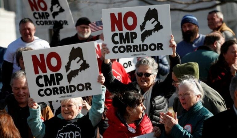
Lead image: Protesters in Maine express their opposition to a planned hydroelectric corridor that will cut through the state as it carries energy from Quebec to Massachusetts. Credit: AP Photo/Robert F. Bukaty
Land Matters Podcast: How Costa Rica Became a Model for Climate Action
By many accounts, Costa Rica has been a unique Central American success story—“a beacon of Enlightenment” and “a world leader in democratic, sustainable, and inclusive economic growth,” according to the prominent economist Joseph Stiglitz.
A nation of about 5 million people roughly the size of West Virginia, Costa Rica has been punching above its weight particularly in the realm of sustainability and climate action: a pioneer in eco-tourism; successful in getting nearly all of its power from renewable sources, including an enterprising use of hydro; and a leader in fighting deforestation and conserving land with its carbon-soaking rainforests.
The Land Matters podcast welcomed two special guests recently who know a thing or two about this country: Carlos Alvarado Quesada and Claudia Dobles Camargo, the former President and First Lady of Costa Rica. They are both in the Cambridge, Massachusetts, area this year—she is a Loeb Fellow, part of a mid-career fellowship program based at Harvard’s Graduate School of Design, and he is a visiting professor of practice at the Fletcher School of Law and Diplomacy at Tufts University.
Former Costa Rican President Carlos Alvarado Quesada and former First Lady Claudia Dobles Camargo at the Lincoln Institute offices in Cambridge, Massachusetts, in April 2023. Credit: Will Jason.
Also in the studio was Enrique Silva, vice president of programs at the Lincoln Institute, who oversees the organization’s research and activities globally, and has years of experience in and familiarity with Latin America.
The conversation, recorded at the Podcast Garage in Allston after a visit by the couple to the Lincoln Institute, included reflections on leadership and climate action, and what it’s been like to take a year to decompress after an eventful time in office, from 2018 to 2022.
Costa Rica has much to show the world when it comes to the implementation of targeted sustainability practices, Quesada said. “We’re not saying people have to do exactly the same [as we did], but we can say it’s possible, and it’s been done in a model that actually creates well-being and economic growth,” he said. “Back in the day, people would say it’s impossible—‘if you’re going to create protected areas, you’re going to destroy the economy.’ It turned out to be the other way around, it actually propelled the economy.”
After seeing big successes in the countryside, the interventions have turned to urban areas. “Costa Rica has done such an amazing job in nature-based solutions, not so much on urban sustainability,” said Dobles, noting the ambitious National Decarbonization Plan she launched with Quesada, which aims to reach net-zero emissions by 2050. “In order to decarbonize, we really needed to focus also on our urban agenda.”
A big task was reinvigorating public transit, starting with a new electric train that would have spanned the city of San Jose. Quesada’s successor shelved the $1.5 billion project, demonstrating the common mismatch between long-term projects and limited time in office. A pilot project to electrify buses was implemented, however, to rave reviews. The couple says they are hopeful the train will be revived.
“I know that this is eventually going to happen. Sometimes you have political setbacks,” said Quesada. “Your administration cannot own throughout time what’s going to happen, but you can plant positive seeds.”
Costa Rica has been nothing if not creative in addressing the many dilemmas inherent in climate action. Open-ore mining is banned, for example, but entrepreneurs figured out a way to extract lithium from recycled batteries.
“That’s very linked to the discussion of the just energy transition, where the jobs are going to come from, where the exports are going to come from. While there’s a huge opportunity for many developing countries which are rich and are endowed with minerals and metals . . . we need to address those complexities,” said Quesada.
Dobles added, “When we talk about decarbonization, we cannot exclude from that conversation, the inequality conversation. This is supposed to provide our possibilities of survival as humankind, but also it’s a possibility for a new type of social and economic development and growth.”
Former First Lady Claudia Dobles Camargo makes a point as former President Carlos Alvarado Quesada looks on. The pair visited the Lincoln Institute office to discuss their climate and sustainability initiatives in April 2023 while spending a year at Harvard and Tufts universities, respectively. Credit: Anthony Flint.
Reflecting on being in the land of Harvard, MIT, and Mr. Bartley’s Burger Cottage, Dobles said she has been immersed in “the whole academic ecosystem that is happening here . . . just to be, again, in academia, sometimes just to receive information, not having the pressure of having the answers . . . . It’s been wonderful.”
“Being a head of state for four years of a country, it’s an experience that I’m currently unpacking still,” said Quesada. “I’m doing a little bit of writing on that, but you get to reflect a lot, because it’s a period of time you live very intensely. In our case, we were not only working with decarbonization, with the projects we mentioned, we [were also working] with the fiscal sustainability of the country. We had COVID. We had [the legalization of same-sex marriage].
“We tend to train ourselves for things that are outside of us, like methods, tools, knowledge,” he said. “There’s a part of it that has to do with training ourselves, our feelings, our habits, our framing, our thinking . . . to address those hard challenges.”
Carlos Alvarado Quesada served as the 48th President of the Republic of Costa Rica from 2018 to 2022, when his constitutionally limited term ended. He won the 2022 Planetary Leadership Award from the National Geographic Society for his actions to protect the ocean, and was named to the TIME100 Next list of emerging leaders from around the world. Before entering politics, he worked for Procter and Gamble, Latin America.
Claudia Dobles Camargo is an architect with extensive experience in urban mobility, affordable and social housing, community engagement, climate change, and fair transition. As First Lady, she was co-leader of the Costa Rica National Decarbonization Plan. Her architecture degree is from the University of Costa Rica, and she also studied in Japan, concentrating on a sustainable approach to architecture.
Cuando pensamos en innovaciones en la urbanización y la construcción, la madera no suele ser lo primero que se nos viene a la mente. Para que no suene tan agresivo, es un material de la vieja escuela. Pero, en el último tiempo, la construcción con masa de madera (mass timber) (que consiste en paneles, vigas y columnas de madera fabricados con técnicas modernas y herramientas de diseño digital avanzadas) ha tenido un crecimiento destacado. Entre otros atributos, los defensores señalan su potencial con relación al impacto climático: al usar masa de madera extraída de forma sostenible, la huella de carbono se puede reducir a la mitad, en comparación con la de una estructura similar hecha con acero u hormigón.
Según el grupo de comercio de madera WoodWorks, hasta septiembre de 2022, se construyeron o diseñaron más de 1.500 proyectos multifamiliares, comerciales o institucionales con masa de madera en los 50 estados del país. Esto representa un aumento de más un 50 por ciento desde el 2020. El Wall Street Journal, en base a los datos del Servicio Forestal de los Estados Unidos, informa que desde el 2014, abrieron al menos 18 plantas de fabricación de masa de madera en Canadá y los Estados Unidos.
Los componentes básicos de la construcción con masa de madera son las placas, columnas y vigas de madera. Son mucho más sostenibles que, por ejemplo, los conocidos tablones de cinco centímetros por diez, gracias a procesos especiales que se utilizan para unir pedazos pequeños de madera y formar bloques de madera fabricados con precisión. El resultado final incluye columnas y vigas de madera laminada encolada (o “glulam”), y paneles de madera contralaminada (o CLT) que pueden tener hasta 3,5 metros de ancho y 18 metros de largo. Los paneles más largos se usan, principalmente, para pisos y techos, pero también para las paredes. El resultado final, como lo expresaron en la publicación en línea de Vox, es “madera, pero como bloques Lego”. Los proyectos de masa de madera más importantes suelen exhibir el material, por lo que se obtienen construcciones cuyos elementos estructurales ofrecen una estética más cálida y orgánica en comparación con aquellas de acero u hormigón.
Desde hace un tiempo, tanto el proceso como el interés en su potencial vienen cobrando fuerza. La masa de madera empezó a utilizarse en Austria y, luego, en toda Europa, en la década de 1990, y, desde entonces, su uso se ha extendido gradualmente al resto del mundo. En una charla TED muy citada del 2013, el arquitecto Michael Green, de Vancouver, dio sus argumentos a favor de este material: “Siento que la madera tiene una función que cumplir en las ciudades”, sostuvo resaltando las propiedades de captura de carbono de la masa de madera (una estructura de hormigón de 20 pisos emitiría más de 1.200 toneladas de carbono, mientras que una construcción de madera capturaría más de 3.000 toneladas). Además, destacó la capacidad que tiene este material de soportar terremotos e incendios.
Cuando Green dio su charla, las estructuras más altas de masa de madera tenían nueve o diez pisos. Sin embargo, Green argumentó que este nuevo proceso de fabricación podría utilizarse con éxito en estructuras con una altura dos o tres veces mayor. “Esta es la primera innovación en la manera de construir rascacielos que observamos en, probablemente, 100 años”, declaró, y explicó que el proceso de ingeniería no sería tan arduo como la tarea de cambiar la percepción general del potencial que tiene la madera. En el último tiempo, esta percepción se ha estado renovando gracias a un aluvión de proyectos atractivos (entre ellos, un complejo de 25 pisos de comercios minoristas y viviendas en Milwaukee, y un hotel y centro cultural de 20 pisos en el noreste de Suecia) y propuestas para edificios de masa de madera aún más altos.
Debido a que la masa de madera se prefabrica en una planta y se envía al lugar de la instalación (a diferencia de las estructuras de hormigón, que se hacen en el lugar), los detalles del diseño deben resolverse de antemano, lo que requiere una planificación y un trabajo de modelado digital exhaustivos. En definitiva, esto puede aumentar la eficiencia de los procesos de construcción, así como requerir menos trabajadores y generar menos desperdicio. Los proyectos de masa de madera siguen incluyendo otros materiales, señala Judith Sheine, una profesora de arquitectura de la Universidad de Oregón (UO) y directora de Diseño del TallWood Design Institute. TallWood es una colaboración entre la Escuela de Diseño de la UO y las Facultades de Silvicultura e Ingeniería de la Oregon State University que se centra en fomentar la innovación de la masa de madera. “Pero la masa de madera puede reemplazar al acero y el hormigón en muchísimos usos, y cada vez es más popular”, afirmó. “Esto se debe a la nueva disponibilidad, pero también a un interés en usar materiales que impliquen menos carbono”.
TallWood llevó a cabo decenas de proyectos e iniciativas de investigación aplicada, en los que se analizaron los más diversos aspectos, desde problemas de codificación hasta desafíos de la cadena de suministro y maneras de mejorar el rendimiento, con el fin de promover el uso de madera con propiedades y diseños superiores. El instituto forma parte de la Oregon Mass Timber Coalition, una asociación entre instituciones de investigación y agencias estatales de Oregón que, en el último tiempo, recibió US$ 41,4 millones en becas del plan Build Back Better Regional Challenge de la Administración de Desarrollo Económico de los Estados Unidos. Este financiamiento tiene como objetivo respaldar iniciativas de investigación vinculadas con el desarrollo del mercado para la masa de madera.
Sin duda, parte de la promesa medioambiental de este novedoso material depende de los detalles menos conocidos, en particular, cómo y dónde se extrae la madera. Los defensores del sector alegan que su expansión no causará una presión indebida en los bosques, en parte porque los productos de masa de madera pueden fabricarse con madera de “poco valor” (como árboles de diámetro pequeño que ya se sacrifican como parte de la mitigación de los incendios forestales, árboles enfermos y, posiblemente, incluso madera de descarte).
Los grupos conservacionistas y otros expertos están actuando con mayor cautela. En 2018, The Nature Conservancy inició una evaluación de varios años del impacto de la masa de madera a nivel global. Se investigaron los beneficios y riesgos potenciales de la mayor demanda de productos de masa de madera para los bosques, y se está desarrollando un conjunto de principios orientativos mundiales para una “economía de los bosques inteligente desde el punto de vista del clima”, buenas prácticas que ayudarán a proteger la biodiversidad y los ecosistemas a medida que el mercado de la masa de madera crece.
A menudo, los constructores y desarrolladores que, concretamente, desean pregonar el uso de materiales de masa de madera insisten en que la forma de obtención se certificó como sostenible, según Stephen Shaler, profesor de materiales y tecnologías sostenibles en la Facultad de Recursos Forestales de la Universidad de Maine. “En este momento, dicha demanda está en el mercado”, afirmó.
Además del interés en la sostenibilidad, existe otra razón a favor de la proliferación de los proyectos de masa de madera: la biofilia o instinto humano de conectar con la naturaleza. Sharler explicó que “el solo hecho de estar en una casa de madera puede generar una sensación agradable”. Este no es un simple juicio subjetivo: pequeños estudios demostraron que los interiores de madera pueden mejorar la calidad del aire, reducir la presión sanguínea y el ritmo cardíaco, y mejorar la concentración y la productividad.
Según se informó, los desarrolladores del edificio de 25 pisos en Milwaukee, Ascent, escogieron la masa de madera, sobre todo, por razones estéticas y por el valor de difusión de su aspecto distintivo. El edificio Ascent, una de las construcciones de masa de madera más altas del mundo, ha sido el centro de atención de los medios, y se le suma otro valor a la exposición pública: si bien es posible que el edificio Ascent, de 86,5 metros de altura, y otros proyectos de muchos pisos no presagien el futuro de todos los rascacielos, demostraron que es posible construir de manera segura y a gran escala con masa de madera. Esto podría persuadir a reguladores y planificadores, sobre todo, a la hora de aprobar construcciones de menor escala que podrían ser más importantes para demostrar el potencial real de la masa de madera. Según las predicciones de Sharler, “es probable que la mayor parte de su uso se centre en proyectos de altura media, de seis a ocho pisos”.
El Código Internacional de la Edificación permite construcciones de madera de hasta 18 pisos. Los desarrolladores de Ascent lograron una variación debido, en parte, a que el diseño final incluía dos núcleos de hormigón. Sheine y Sharler recalcaron que la mayoría de los proyectos de masa de madera siguen incluyendo al menos algo de hormigón, acero y otros materiales. Y está bien, añade Sharler: la masa de madera debería verse como una opción relativamente nueva que puede ayudar a mejorar la huella de carbono, y no como un sustituto absoluto de los materiales tradicionales. Además, las opciones nuevas siempre son útiles, incluso cuando provienen de la vieja escuela como la madera
Rob Walkerperiodista; escribe sobre diseño, tecnología y otros temas. Es el autor de The Art of Noticing. Publica un boletín en robwalker.substack.com.
Imagen: La construcción con masa de madera. Crédito: Cortesía de ACSA.
En ediciones anteriores, más de una vez lamenté nuestra afinidad cultural con las soluciones simples a los problemas complejos y les recordé a los lectores que no existe un camino fácil para resolver la crisis de accesibilidad a la vivienda. Pero, para aprovechar el espíritu de las resoluciones de Año Nuevo, y a sabiendas de que es fácil poner en ridículo soluciones que son una tendencia pasajera y más difícil proponer alternativas viables, haré el intento de describir un enfoque a la vivienda que creo que puede ser eficaz.
Los problemas complejos deben abordarse desde varios frentes. Para afrontar la crisis de vivienda asequible, tenemos que hacer tres cosas, como mínimo. Primero, debemos defender y preservar nuestra reserva actual de viviendas asequibles. Segundo, debemos identificar y resolver problemas sistémicos que nos impiden producir viviendas nuevas. Tercero, necesitamos identificar y cultivar oportunidades, incentivos y enfoques nuevos que expandan nuestro potencial productivo y faciliten la producción.
Debemos crear una cartera de soluciones con numerosas políticas en cada una de estas categorías. En este número de Land Lines se documentan algunas maneras en que los gestores de políticas están haciendo eso. A su vez, se incluye un artículo destacado de Anthony Flint sobre el interés cada vez mayor en reformas de zonificación a nivel estatal, y la resistencia local a esas iniciativas. Loren Berlin aporta una historia sobre un proyecto descomunal a cargo del Port of Cincinnati, destinado a que el parque de viviendas unifamiliares de la ciudad siga estando disponible para la compra por parte de las familias locales y fuera del alcance de inversionistas externos. Jon Gorey examina iniciativas para preservar y expandir las viviendas prefabricadas, un componente crítico que suele subestimarse de la oferta de viviendas asequibles del país. Por mi parte, ofreceré una contribución a la tercera categoría, un abordaje centrado en el suelo con un gran potencial para expandir la producción: la reutilización adaptativa de edificios comerciales.
Según la asociación de la industria del comercio, el Consejo Internacional de Centros Comerciales (ICSC, por su sigla en inglés), en los Estados Unidos existen 115.857 centros comerciales. Esto incluye 1.220 centros comerciales grandes (con un promedio de alrededor de 83.500 metros cuadrados destinados a locales comerciales minoristas y 28 hectáreas de tierra) 68.936 franjas comerciales de locales (en promedio, 4.000 metros destinados a locales minoristas y cerca de una hectárea de suelo); y miles de otras tiendas de descuento, tiendas de fábricas y centros comerciales barriales (que suman más de 370.000 millones de metros cuadrados destinados al comercio minorista y 160.000 hectáreas de suelo). Incluso antes de la pandemia, una parte significativa de estos centros se vieron amenazados por el comercio en línea. Hace ya tiempo que los conocedores del mercado inmobiliario predijeron que un cuarto de los centros comerciales más grandes de los Estados Unidos corrían riesgo de cerrar. La pandemia solo intensificó este declive. A pesar de que los centros comerciales vacantes pasaron a ser lugares convenientes para el testeo y la vacunación masivos de la COVID, los expertos empezaron a predecir que más de un tercio de los grandes centros comerciales quedarían vacantes o abandonados en los próximos años.
Las crisis y las oportunidades suelen ser buenas aliadas. La crisis de los comercios minoristas nos ofrece lo que podría ser nuestra mejor oportunidad para resolver la crisis de las viviendas. Por ejemplo, en el Área de la Bahía de San Francisco, uno de los mercados de viviendas más complicados del país, Peter Calthorpe estima que podríamos construir 250.000 unidades de vivienda nuevas mediante la reconversión de espacios minoristas infrautilizados a lo largo de una sola ruta, El Camino Real, que se extiende unos 65 kilómetros desde San José hasta San Francisco y atraviesa 16 municipios. Esto podría aliviar la grave escasez de viviendas en la región, y generaría suficiente densidad residencial para apoyar el transporte público, lo que contribuiría con los esfuerzos del estado y la nación para mitigar la crisis climática. Además, el crecimiento demográfico podría generar suficiente tráfico a pie para apoyar múltiples actividades comerciales. Con esta triada, la gran pregunta es: ¿por qué aún no comenzó el redesarrollo de El Camino Real? Principalmente, debido a diversos factores causados por las personas que complican la situación.
Como ya observé en otras oportunidades, el redesarrollo es más difícil que la urbanización de lugares sin desarrollo previo. Implica deshacer lo que ya se hizo en el lugar, mientras se intenta que múltiples partes involucradas con diferentes intereses converjan en una visión compartida. Y lo que es mucho peor, surgen complejos obstáculos generados por las personas. Primero, los estímulos fiscales adversos interfieren con la disposición de las jurisdicciones a considerar el cambio del uso del suelo. Las propiedades comerciales generan una gran parte de la renta local, no solo por medio de los impuestos a la propiedad, sino también a través del porcentaje local de los impuestos sobre las ventas y otras comisiones y cargos. El redesarrollo residencial podría reemplazar solo una pequeña parte de la renta perdida. Segundo, los proyectos de redesarrollo son difíciles de financiar. Proyectos nuevos y visionarios podrían entusiasmar a los emprendedores inmobiliarios; son señales de incertidumbre y riesgo para las entidades crediticias y las aseguradoras. Tercero, el redesarrollo de un corredor comercial para convertirlo en un espacio residencial o de uso mixto implica cambios de zonificación, un tema que genera mucha tensión. En el caso de El Camino Real, haría falta que 16 consejos de zonificación aprobaran la rezonificación para que el proyecto avance. Si bien, probablemente, no sería necesaria una participación unánime de las 16 ciudades y pueblos, se requeriría una masa importante para que el redesarrollo manifestara su potencial.
Redesarrollar propiedades comerciales para proyectos de uso mixto con mayor densidad es difícil, pero no imposible. Cada uno de los obstáculos mencionados puede superarse, y de hecho, todos han sido sorteados en otros lugares. Por ejemplo, uno de los proyectos de desarrollo más grandes del país, el Tyson Partnership en Tyson, Virginia, está redesarrollando un distrito comercial de más de 1.100 hectáreas para convertirlo en un desarrollo de uso mixto con buen acceso para el transporte público. El proyecto ha estado en marcha por más de una década y ya incluye 11 edificios residenciales multifamiliares. En Partnership pretenden cuadruplicar la población residencial de la “ciudad periférica” que supo ser un prototipo y que proporcionó viviendas para 25.000 personas, pero dio empleo a alrededor de 125.000. Están evaluando cuatro paradas nuevas en la Silver Line del metro de Washington para que esta se convierta en el centro urbano del condado de Fairfax, con la esperanza de que llegue a ser el emblema del “nuevo nuevo urbanismo”.
En Memphis, un centro de distribución de Sears que estuvo abandonado por casi tres décadas se redesarrolló y reconvirtió en una “zona urbana vertical” llamada Crosstown Concourse. El edificio de 10 pisos sobre 6.500 hectáreas de suelo ahora aloja una escuela autónoma, un centro de artes escénicas, más de 55.000 metros cuadrados de espacio comercial y 270 departamentos. Ya está impulsando desarrollos nuevos en los barrios circundantes.
Fuera de Seattle, desarrolladores están construyendo una tienda ancla nueva para el centro comercial suburbano Alderwood Mall, que cuenta con 300 departamentos y estacionamiento subterráneo. Esto compensará la pérdida de la tienda ancla anterior, Sears; hará frente a la alta demanda de viviendas en un mercado de viviendas extremadamente agobiado, y proporcionará una base de consumidores que compren en el resto de las tiendas del centro comercial, al que le está resultando difícil sobrevivir.
Si bien, probablemente, no sean tan extensos como El Camino Real, existen cientos y cientos de corredores comerciales desaprovechados a lo largo del país. Si lográramos reconvertirlos en desarrollos de uso mixto y densidad media, podríamos reducir en gran medida el déficit nacional actual de vivienda. A su vez, no escasean los edificios comerciales abandonados o infrautilizados como Sears Crosstown, los distritos comerciales ocupados a medias como Tyson, y los megacentros comerciales abandonados o en decadencia como Alderwood, que ofrecen excelentes oportunidades similares para el redesarrollo.
Según mis cálculos muy prudentes, si redesarrollamos el 20 por ciento de estos espacios comerciales para que alcancen estándares de uso mixto con una densidad de baja a media (25 viviendas por hectárea), podríamos sumar 1,1 millones de unidades de vivienda nuevas y preservar decenas de miles de metros cuadrados de espacio comercial con mayores probabilidades de prosperar. Si redesarrollamos el 25 por ciento de los lugares con 37 viviendas por hectárea, podríamos sumar 2,1 millones de unidades de vivienda. Y si pudiéramos redesarrollar el 30 por ciento de los lugares con 50 viviendas por hectárea, podríamos sumar 3,4 millones de unidades de vivienda nuevas.
Este no es un desafío técnico. Ya hace décadas que desciframos el código sobre la reutilización adaptativa. Debemos simplificar el proceso para facilitar el redesarrollo escalonado y establecer nuevas sociedades público-privadas más eficaces para poder lograrlo. El sector público debe redoblar la apuesta para eliminar el riesgo de los proyectos a través de la aceleración de los permisos, el cofinanciamiento e incentivos financieros inteligentes. El sector privado debe dejar de intentar construir en suelos vírgenes y buscar formas más creativas de redesarrollar los sitios obsoletos. Para visualizar los tipos de desarrollos posibles, basta con observar la obra maestra de Juie Campoli Made for Walking(Hecho para caminar), publicada por el Instituto Lincoln en 2012. Con miles de lugares para escoger, podemos definir cómo queremos producir y reproducir los tipos de barrios que se describen en el libro, y reducir los riesgos percibidos del desarrollo con cada proyecto exitoso.
El asediado sector comercial ofrece la mayoría de los elementos necesarios para hacer frente a la crisis actual de vivienda. Tiene suelo provisto de la infraestructura básica (agua, cloacas, electricidad) y que, por lo general, es de fácil acceso para el transporte público o, de no serlo, se encuentra rodeado de estacionamientos. En general, las ubicaciones son privilegiadas. Al mezclar los usos, ofrecemos dos beneficios enormes para el sector comercial: trabajadores y clientes. Pero los beneficios para la sociedad son aún más profundos. Así que adoptemos esta estrategia, junto con la reforma de zonificación unifamiliar y la preservación de la vivienda asequible, y veamos si podemos resolver la crisis nacional de vivienda de una vez por todas.
Imagen: La celebración inaugural de Crosstown Concourse, un proyecto de uso mixto donde antes funcionaba un centro de distribución de Sears en Memphis. Crédito: Crosstown Concourse.
The Second Wave: Why Floods Can Follow Wildfires, and How Communities Can Prepare
By Amanda Monthei, March 30, 2023
SHARE
Most people in the mountainous northeastern corner of New Mexico were looking forward to the arrival of the annual monsoon season last summer. The Hermits Peak–Calf Canyon wildfire had started in April, burning 340,000 acres and destroying hundreds of properties, and residents were hoping for a reprieve from the smoke and evacuations that had begun to define their lives. But then the monsoon arrived, both unseasonably early and with more intensity than normal.
As the rains pelted soil that had been rendered water-repellent by the fire, mud and water cascaded down the slopes of the Sangre de Cristo Mountains into the waterways, fields, roads, and homes below. Still reeling from the fire, residents were forced to deal with a fresh disaster—in many cases, needing to leave their homes once again.
“Their homes were flooded, their corrals were taken out, their burnt barns were taken out,” said Veronica Serna, county commissioner in Mora County, one of the areas hardest hit by the fire and the floods. “One family had a boulder come down and block their whole driveway. They didn’t have any water and no way to go out and get water—just imagine not being able to shower in your own home or wash your hands or use a toilet. It was devastating.”
Serna recalls another family “whose home kept getting flooded over and over and over. One day we stopped by to check on them, and they were scraping the mud out of their shoes, shoveling mud out of their bedroom. It’s just so hard to see that.”
The flooding also affected San Miguel County just to the south, damaging homes and infrastructure, polluting wells, and threatening water supplies. “Most people are back within the community, but they’re still stressed out about the future, because the flooding is not going to stop,” said Ralph Vigil II, a farmer and water commissioner who grew up in San Miguel County and runs a farmers’ cooperative there. “I’m afraid that we’re going to be dealing with this for years.” According to the Federal Emergency Management Agency, flood risk remains elevated for up to five years after a wildfire, until vegetation is restored.
Vigil had the opportunity to take a helicopter flight over the burn scar in the fall, after the fire was fully contained and the worst of the flooding had subsided. “You don’t really understand the vastness of the damage until you’re up there,” he said. He was alarmed, and not just by the decimation of landscapes and communities that he’s long loved: “I also saw the risk for more fires, and really the signs of what’s to come.”
As climate change contributes to longer, more intense wildfire seasons, fires are leaving burn scars across the U.S. West, putting nearby communities at risk of flooding. That flooding, which can be catastrophic, can occur long after the fire is over. In the face of these threats, communities can make land use decisions that help build their resilience.
After the Fire, the Deluge
It’s apt that the name of the Sangre de Cristo Mountains, which extend from Colorado to their terminus near Santa Fe, translates as “Blood of Christ.” The ridges, valleys, and bowls that would have been dwarfed from Vigil’s viewpoint in the helicopter make up the bulk of two watersheds that are the lifeblood of downstream communities and farmlands. Some 23,000 people in San Miguel and Mora counties rely on these watersheds for drinking water and agriculture.
Under the right conditions, naturally occurring and prescribed fires support ecosystem health. But the Hermits Peak–Calf Canyon fire, the largest in New Mexico’s history, got out of control and caused chaos. Twenty-four percent of the burn area was classified as high-severity fire, causing extensive tree mortality and profound impacts to soil. When trees and vegetation burn in high heat, they release gases that harden the soil into a water-repellent, concrete-like material. That allows rain to run over the forest floor like it would a sloped parking lot, picking up speed and sediment before flooding into the communities below.
A soil scientist from the federal Burned Area Emergency Response (BAER) team inspects conditions in the Hermits Peak–Calf Canyon burn scar in June 2022. The fire rendered soil in the burn scar water-repellent, creating conditions for flooding and debris flow. Credit: U.S. Forest Service.
“Pre-fire, these forested ecosystems and slopes work like a sponge, but post-fire, nothing is going to stop that rain,” says Micah Kiesow, a soil scientist for the Santa Fe National Forest and team lead for the fire’s Burned Area Emergency Response (BAER) team. BAER teams assess wildfire damage on federally owned lands. “We saw a tremendous amount of erosion, sedimentation, and debris flows in the most severely burned areas, which eventually makes its way to the drainages and streams below.”
Credit: Federal Emergency Management Agency/FEMA.gov.
While post-fire flooding affected many communities around the burn area, some of the worst damage occurred in Mora County. The county, one of the poorest in the nation, has about 2,130 homes scattered across nearly 2,000 square miles. Serna estimates that 200 of those homes were burnt over and countless others impacted when ash, water, and sediment flowed into the communities of Mora, Holman, Chacon, and Guadalupita. “It’s sad, because our communities had a lot of adobe homes,” she said. “Our people have lived here for generations, they have inherited these adobes from their great-, great-, great-grandparents.”
Many of those affected were rural farmers. According to Serna, numerous residents had freezers full of high-quality cattle and game meat that had to be thrown away following power outages in the aftermath of the flooding. Meanwhile, the acequias—small ditches or canals that divert water from creeks and rivers to provide water to farms and form the foundation of water access in this part of New Mexico—were clogged with wood, rocks, and mud. Over 40 acequias were destroyed in the aftermath of the fire, according to the New Mexico Acequia Association and reporting by Source New Mexico. The infrastructure that these remote communities rely on for everything from growing food to accessing critical services suffered profound damage.
In the immediate aftermath of the fire, it was difficult to access federal emergency funding. In later months, however, significant funding opened up for those affected by the fires—some $3.9 billion total, including $2.5 billion from the federal Hermits Peak–Calf Canyon Fire Assistance Act passed in September and $1.4 billion allocated in the 2023 Omnibus Appropriations bill. Total damages for the fire have not been confirmed, but some estimates put it as high as $5 billion.
Despite the influx of funding, “I really don’t think [$3.9 billion] is going to be enough,” Serna said. “How do you replace trees that were over 100 years old? How do you get all that back? I mean, is there a dollar amount that could do that? How do you buy back time?”
Smoke from the Hermits Peak–Calf Canyon looms behind the town of Mora, New Mexico. Fire and flooding destroyed many of the community’s traditional adobe structures. Credit: Reuters/Andrew Hay.
While the recovery effort continues, the risk for more flood damage persists, hinging precipitously on the intensity of future rain and snowmelt events. Mora County officials have begun developing a hazard mitigation plan for potential impacts from fires and flooding in the future. This kind of planning is one of many steps communities need to take to become more resilient in the face of increasingly frequent and severe disasters.
From Reactive to Proactive
In many cases, communities address the risk of flooding after a fire, but time isn’t always on their side. “The challenge in New Mexico is we have a fire season from April to June, immediately followed by a monsoon season,” said Brian Williams, director of emergency management in Santa Fe. “That window of time between when the fire season ends and the flooding season begins is weeks, not months. Often it overlaps, and then it’s a mad scramble to mitigate those potential impacts as best you can. And the kinds of things that you can do are to some degree limited.”
When BAER teams assess the extent of damages in federally owned areas, part of their charge is to determine priorities for immediate mitigation measures—ideally before extreme precipitation arrives. These often-forested ecosystems are prime candidates for aerial seeding and mulching, which can help burned areas begin to recover; restoration of stream channels can also help address flood risk. To prepare for the New Mexico monsoons, the BAER team also recommended and oversaw a number of emergency interventions including installing obstructions in stream channels to redirect debris and sediment and making fixes to bridges and culverts to facilitate vehicle access. These measures likely helped minimize some of the most extreme impacts of the rains, but it’s difficult to quantify their effect—and the hard truth is that only so much can be done in the timeline between fire suppression and extreme rain events. Harder still is the fact that that timeline seems to be shrinking in many regions.
Flood control in the areas affected by the Hermits Peak–Calf Canyon fire included the installation of temporary dams. Credit: U.S. Army Corps of Engineers.
A lot of the conversation around post-fire flooding focuses, understandably, on ecosystem recovery measures like those that BAER teams recommend and facilitate. But effectively preparing for the unique challenges of recovery and potential post-fire erosion events also requires significant forethought on the part of communities and homeowners.
Planning and land use decisions can minimize risk before fires occur. On the ground, communities can install infrastructure to help contain or redirect debris flows; retrofit homes with more ignition-resistant materials; and identify and improve evacuation routes. They can also reduce hazardous fuels in forests and create defensible space around structures by thinning trees and other vegetation Some fuel-reduction work, which is an essential forest management tool, comes with risks; the Hermits Peak–Calf Canyon fire was the result of two U.S. Forest Service fires that went awry: a prescribed burn and a pile burning project. The fires combined and spread due to high winds. But under the right conditions, prescribed burns can reduce the risk of wildfire and help maintain ecosystem health.
On a policy level, communities can take steps including prohibiting or limiting development in areas vulnerable to fire and flooding. Where development is allowed, they can mandate the use of certain building materials, such as fire-resistant siding. Local and regional officials can also map wildfire and debris flow risks to help determine when and where to build; develop pre-disaster plans, which allow communities to consider how they will handle recovery challenges such as restoring electricity, providing temporary housing, or managing long-term rebuilding; and proactively budget for projects such as stormwater treatment infrastructure upgrades, which can help communities better cope with flooding. Communities can also engage in scenario planning, a process that can help them identify and plan for various possible futures.
Scenario Planning for Wildfire Resilience
Scenario planning can help communities plan for an uncertain future. The practice guides planners, community members, and other stakeholders through considerations of various futures and how to effectively respond to and plan for them. In the case of wildfires, communities can consider the impacts of a changing climate on factors including public health, housing, equity, the economy, water availability, and quality of life. How could more frequent and intense drought affect wildfire suppression efforts? How can coordinated regional climate policies reduce wildfire risk and improve quality of life? By asking questions like this and exploring multiple possible outcomes, communities can better prepare for the challenges ahead. To learn more about this planning practice or to get assistance running a scenario planning process, visit the Lincoln Institute’s Consortium for Scenario Planning.
According to a report from the National Institute of Building Sciences, every $1 of public funding spent on hazard mitigation since 1995 is expected to save $6 in future disaster costs. After decades of focus on disaster recovery funding, the federal government has begun a shift toward funding pre-disaster planning and mitigation. FEMA has released a pre-disaster planning guide and has made limited funds available for disaster mitigation projects. Unfortunately, this kind of advance planning often hinges on the kind of political will and funding that are still much easier to come by after disaster has struck.
“I think the fundamental challenge with all of this, as with most natural hazards, is it’s very hard for us to plan ahead for things,” said Dr. Kimiko Barrett of Headwaters Economics, a Montana-based nonprofit research group that works to improve community development and land management decisions across the country. “We are by nature reactive and responsive, in contrast to being anticipatory. Even after a wildfire occurs, we have a small window to actually mobilize and enact the transformative change needed before amnesia kicks in, or bias kicks in, where you feel that [because the fire] happened, it will never happen again.”
A Holistic Approach
As more areas are affected by increasingly destructive wildfires, the threat of erosion and flooding in these landscapes will also increase—and should be factored into planning and land use decisions, Barrett says. She explains that the principles of holistic land use policy for wildfire resilience are inherently connected to planning for potential post-fire impacts like flooding. The measures typically used to build community resilience to wildfire—things like reducing hazardous fuels near critical infrastructure, planning evacuation routes, considering home density and development patterns in new developments, and mapping risk—also provide intrinsic benefits in the post-fire period.
“[Taking these actions] means communities have a greater chance of surviving a wildfire—therefore, that rebuilding and recovery piece is inherently better situated, because you’ve put that thought and that deliberate strategic planning in on the front end,” Barrett says. “So [planning for wildfire and its impacts] have to be wedded together. The challenge is that federal funding and policy does not often address it in that nature, or within that holistic framing.”
Quantifying and addressing the highly localized hazard planning needs of individual communities—from mapping risk to implementing mitigation at a meaningful scale—is also challenging when an area hasn’t yet felt the impacts of a wildfire or post-fire disaster. Risk mapping, for example, makes it less challenging to predict where and how a wildfire might impact a landscape; yet it remains challenging to create comprehensive and accurate maps, not only because of the robust data needed to make such predictions, but also because of community resistance.
“There’s a lot of pushback—much like you see on sea-level rise and other things in Florida and elsewhere—where politicians, developers, and community leaders are like, ‘We don’t really want to know—or we might want to know, but we really don’t want it publicized,’” said Molly McCabe, CEO of HaydenTanner, an investor advisory firm that focuses on social impact and sustainability in the built environment. “So you have this tension between, ‘We want to keep our people safe,’ and ‘It’s also an economic risk.’”
In 2022, the state of Oregon created a statewide wildfire risk map, distributing it to 150,000 residents who lived in areas facing high or extreme risk. Controversy arose quickly: homeowners suspected that the map might affect property values and insurance rates, and some worried that it could lead to new building codes or mandates for home hardening—a retrofitting approach that involves steps ranging from replacing windows to trimming nearby trees and shrubs. The Oregon Department of Forestry withdrew the map for further development, but the response was a clear reflection of the challenges related to getting out ahead of risk.
Oregon’s Wildfire Risk Explorer tool maps risk factors ranging from flame length to susceptibility, using data from a 2018 assessment. The state released an updated map last year, but withdrew it for refinement based on the response from property owners. Credit: Oregon State University/Oregon Department of Forestry.
This problem grows even muddier when it comes to planning for erosion and flooding events after wildfires—how can you meaningfully quantify the potential impacts of a disaster that is the result of another disaster, which is also relatively difficult to predict? And how can you garner the essential buy-in of residents who could be financially affected by a better understanding of the risk in certain areas?
Despite these challenges, some communities are making progress, Barrett said: “I can tell you that there are communities that recognize their level of risk, and are addressing it in aggressive ways that go beyond what we’re seeing from federal mandates or state regulations.”
Communities Taking Action
Barrett said some communities in California have implemented mandates beyond existing state requirements for ignition resistance standards. Portola Valley, for example, adopted a home-hardening ordinance to supplement the state building code, which requires ignition-resistant building materials for new developments in high-risk areas. In 2020, residents in Marin County approved a measure that applies a property tax of 10 cents per square foot to support wildfire prevention efforts. The measure, which includes exemptions for low-income senior citizens, is expected to generate nearly $20 million per year over a 10-year period.
Both Barrett and McCabe mentioned that bond proposals have been a successful—though not yet widely utilized—means for motivated communities to set aside funding for wildfire and post-fire resilience. One particularly notable example is the Flagstaff Watershed Protection Project (FWPP), initiated after the Schultz Fire burned 15,000 acres in the mountains north of the city in 2010. The fire itself had little impact on homes and private property in Flagstaff, but a month later heavy rains triggered debris flows and floods that swept into the valley, causing the death of a young girl and the loss of 85 homes. Two years later, residents approved a $10 million bond that would help protect the watershed and adjacent homes and properties against similar impacts.
Flagstaff residents contend with the effects of post-wildfire flooding in 2010. Two years later, the community passed a $10 million bond to support efforts to reduce wildfire and flood risks in the watershed. Credit: Josh Biggs/Arizona Daily Sun via AP Images.
FWPP is a partnership between the state, city, and Coconino National Forest intended to help reduce the risk of both wildfire and post-fire flooding. “This has become one of the best examples I’ve seen out there of a partnership that has really resulted from a pretty devastating event that was post-fire related,” Barrett said. “It’s just a really good example of what can happen when the right players are there, and of communities and local partners recognizing a risk and acting on it.” Last year, voters in Flagstaff showed sustained support for continuing the city’s wildfire suppression and stormwater management efforts, with 76 percent approving a proposal to issue $57 million in bonds to invest in water- and fire-related infrastructure.
McCabe mentioned Montecito, California, as another notable example of community resilience arising from tragedy. The 2017 Thomas Fire destabilized slopes above Montecito. When these slopes were subjected to a deluge of rain just a few weeks later, 23 people lost their lives and 130 homes were destroyed. Since then, Santa Barbara County officials have developed debris flow risk maps for the area, while a community-led nonprofit called the Project for Resilient Communities facilitated the installation of steel mesh netting to catch debris in drainages above the community.
Workers install a mesh net in San Ysidro Canyon above Montecito, California, in 2019. Credit: Christy Gutzeit.
In Montecito and other communities, McCabe says, “people are voluntarily using grants and other monies to build their homes up on 10-foot elevated pads, so that if they’re in a path, the mud flows around them. But I haven’t seen any policies that are requiring that for new construction, much less existing construction.”
Still, local or regional policy can support such individual actions. Grants or insurance incentives can be offered to homeowners who create defensible space around their home, or to those who retrofit their homes with ignition-resistant materials. Programs like FireWise USA, an initiative of the National Fire Protection Association, can help neighborhoods organize collective fire mitigation projects and hold residents accountable for maintaining properties over time.
Getting buy-in at the local level also hinges on communicating strategically. In Central Washington’s Chelan County, public information campaigns around wildfire risk reduction included translators who could engage Spanish-speaking communities. Engaging with non-English speaking and migrant communities, in addition to other communities that are at disproportionate risk of wildfire and post-fire flooding, is an important component of public information campaigns throughout the process—from preparing for wildfire to navigating the recovery stage.
A Watershed Moment
In 2012, a major wildfire burned 87,000 acres near Fort Collins, Colorado. In the months following the fire, ash and mud choked the Poudre River, which provides drinking water for 135,000 downstream residents. Sediment clogged the pipes of the local water treatment plant, requiring extra clean-up and treatment and leading the city to install sensors that monitor sediment in the river. “We had been privileged and in some ways probably took for granted that these watersheds were providing us consistently clean, clear water, all the time,” the city’s water quality manager, Jill Oropeza, told a local radio station. “That was the first time, for many of us working there, that we had to grapple with the fact that our watersheds are under pressure.”
According to the U.S. Forest Service, the forested watersheds of the United States provide drinking water for 180 million people. Ninety-nine percent of people who rely on public water systems in the United States get at least some of that water from forested ecosystems. Research suggests that post-wildfire flooding contaminated the drinking water of hundreds of thousands of people in the West between 2017 and 2020.
In Mora County, “people sent me photos of turning their water on and having sludge come out,” said Serna, the county commissioner. Many wells were destroyed, with some residents only getting their water back online in October and November. The city of Las Vegas, in nearby San Miguel County, almost ran out of water for its 13,000 residents after debris from the fire found its way into the local reservoir. With only 20 days’ worth of clean water remaining, the city used emergency state funding to convert a local lake into a short-term back-up water source. Longer-term relief came in the form of $140 million from the omnibus bill that will allow Las Vegas to invest in water treatment and filtration upgrades.
Maria Gilvarry, utilities director for Las Vegas, New Mexico, said the flooding caused by the Hermits Peak–Calf Canyon fire was “beyond anything we could have fathomed.” The city is using federal funds to invest in water treatment upgrades. Credit: Nadav Soroker/Searchlight New Mexico.
In response to situations like these, organizations including the Coalition for the Poudre River Watershed in Fort Collins and the Greater Santa Fe Fireshed Coalition, which focuses on a high-risk area just south of the Hermits Peak–Calf Canyon fire area, are bringing stakeholders together to better understand the risks wildfire poses to water supply and water quality. Many communities in the West take great pride in the places where their water comes from. Protecting watersheds from high-severity wildfire—and, thus, debris flows—is an easy sell to the communities that rely on the resources these ecosystems provide, and building resilience in watersheds inherently builds resilience for downstream communities.
Whether focused on making a watershed more resilient, guiding development to less vulnerable areas, or envisioning and preparing for multiple possible futures, communities can take many steps to build resilience to wildfire and post-fire flooding. The profound influence of past and present land management decisions on wildfire and flood outcomes makes it increasingly clear that we can better prepare for events that are exacerbated by human actions—and, in some cases, inaction. Adequately planning for wildfires and subsequent debris flows or flooding in the West requires significantly more funding, resources, and creative policy solutions than are currently available, but taking action and making investments on the front end can lead to stronger communities that are better prepared to face future disasters.
Amanda Monthei is a freelance writer, podcast producer, and former wildland firefighter whose work on wildfire adaptation and resilience has been featured in The Atlantic and The Washington Post, as well as on her podcast Life with Fire. She lives in Bellingham, Washington.
Lead image: Smoke from the Hermits Peak–Calf Canyon wildfire over Las Vegas, New Mexico, in May 2022. Credit: Robert Browman/Albuquerque Journal via AP Images.
Uncertain Futures: Integrating Land and Water Planning in an Era of Climate Volatility
By Heather Hansman, March 21, 2023
SHARE
“Climate change is water change.” It’s an adage that has caught on in certain circles, as our shifting global systems affect every part of the water cycle. In the United States, that has looked like record drought and aridification in the West, massive flooding in the Midwest, and superstorms in the East. Those climatic changes have also created secondary impacts, like land subsidence, longer wildfire seasons, and contaminated water supplies. And all these effects are complicated by factors ranging from population growth to aging infrastructure.
As these impacts hit every corner of the country, planners and water managers are finding new ways to address them, working together to build resilience in the face of an increasingly volatile climate. Planning for a future that could include an unpredictable combination of drought, flooding, pollution, and other water-related issues takes a significant shift, says Bill Cesanek of the American Planning Association’s Water and Planning Network. “Historically, U.S. communities have dealt with land use planning and water management in separate silos,” Cesanek says. “But now we know we have to manage them using an integrated approach.”
Traditionally, he explains, water departments and planners have often worked within different geopolitical boundaries, management structures, and timelines, even as their work has overlapped on the ground. But with communities growing rapidly, especially in the South, and climate change exacerbating water-related risks, planning is becoming more complex, and the need for collaboration more urgent.
“We need an integrated and multidisciplinary approach,” agrees Brenda Bateman, director of the Oregon Department of Land Conservation and Development. Bateman is chair of the American Water Resources Association’s Land and Water Specialty Conference, an event focused on connecting land and water for healthy communities. “These problems are so thorny that if we try to solve them one by one, or in a vacuum, we end up with solutions or results that don’t stick. They’re tied together regardless of how our budgets and bureaucracies work.”
The goal of improving planning and resource management processes so they are more integrated, resilient, flexible, and creative is complicated by regional differences—“what works in California won’t necessarily work in New Jersey,” Cesanek says. And since the nature of climate volatility means what works in California today won’t necessarily work in the future, planners and water managers have to prepare for many possible scenarios.
“In the planning world, it used to be ‘let’s envision the highly desirable future we want, and build to that,’” says Jim Holway, director of the Lincoln Institute’s Babbitt Center for Land and Water Policy. “Now we have to put in place policies that will be robust across different futures—not just desirable ones—and bring in programs that are more adaptive. This is a shift in approach.”
Anticipating potential futures and changing practices to account for uncertainty is tricky, but not impossible. And despite the local nature of planning and resource management, shared practices and strategies can work across the country. Here’s how three communities facing different challenges are adapting their approaches and practices to prepare for a changing future.
New Orleans: Living with Water
Few cities have spent as much time and energy fighting water as New Orleans. The city was built on a natural levee along the Mississippi River, a prized location that offered obvious economic and environmental benefits. But centuries of efforts to engineer the river and drain the surrounding swamps led to land subsidence so severe that some neighborhoods are up to 11 feet below sea level, making them prone to frequent flooding. New Orleans is also one of the rainiest places in the country, with five feet of annual precipitation, and is vulnerable to the increasingly strong hurricanes that frequent the Gulf Coast.
Centuries of efforts to fight water are giving way to a new philosophy in New Orleans. Credit: pawel.gaul via E+/Getty Images.
When Hurricane Katrina hit in 2005, inundating 80 percent of the city, it explicitly revealed a truth that had been gradually coming to light: New Orleans couldn’t use its historical approaches to fight the stronger storms and rising waters of climate change. It had to think differently.
“Katrina was a tipping point,” says Ed Blakely, a global urban policy expert who led the city’s recovery effort. Blakely says the city’s previous approach to water—attempting to overpower it rather than planning around natural streamflow and flood patterns—reflected a common urban pattern in the United States: “We have not used history to plan settlement.”
As the urgent work of recovery got underway, a new approach to long-term planning began to emerge as well. With support from a state community resilience fund powered by federal disaster recovery dollars, the region’s economic development organization, Greater New Orleans, Inc. (GNO) commissioned a project that would help the city reimagine its relationship to water.
Inspired by the Dutch approach to water management, which hinges on collaborating across disciplines and viewing water as an asset, the Greater New Orleans Water Plan drew on local, national, and international expertise, envisioning nature-inspired systems and strategies that could help manage stormwater more effectively and contribute to the health of residents, ecosystems, and the economy. The green infrastructure proposals in the plan ranged from small-scale retrofits like bioswales and permeable pavement to the more comprehensive strategic use of parks, canals, and waterways to slow and store water.
The ambitious plan intentionally focused on physical space, not policy or politics, explains Andy Sternad, an architect and resilience expert who was a lead author of the plan for New Orleans–based firm Waggonner & Ball. It won acclaim from organizations including C40 Cities and APA, which gave it a National Planning Excellence Award in 2015, in part due to its collaborative nature. “Planners have been instrumental in communicating with designers and engineers about the spatial, socioeconomic, political, and cultural impacts of the plan,” APA noted in its award description. “They have also been successful in integrating the Urban Water Plan with the Louisiana Coastal Master Plan and other local planning processes.”
“The water plan facilitated a new way for us to approach water, locally and regionally,” says Robin Barnes, a New Orleans-based economic recovery and resilience consultant who is the former executive vice president and COO of GNO, Inc. “It provides us with information and schematics and instructions about everything from materials to specific demonstration projects, and it illustrates how living with water can work.”
Barnes has been a director on the Sewerage & Water Board of New Orleans (SWBNO) since 2014, and says she has seen the plan’s guiding philosophy seep into operations citywide and regionally. The idea of living with water can be seen in everything from stormwater storage requirements for new construction and pilot projects funded by the SWBNO to broader initiatives such as the Gentilly Resilience District, a multi-pronged effort to reduce flood risk and support revitalization across an entire neighborhood. The city has received significant federal funding for green infrastructure, including a major award from the U.S. Department of Housing and Urban Development’s National Disaster Resilience Competition.
The city’s master plan envisions that by 2030, New Orleans will become “a city that celebrates its relationship to water.” The plan prioritizes water conservation, sustainable stormwater management, and the protection of wetlands and other areas needed for water storage. It endorses land use approaches that were key elements of the post-Katrina rebuilding effort, says Blakely, such as density, infill development, and building on high ground.
Recommendations like those are constructive outcomes of the devastation caused by Katrina. So are community-level conversations about water management and resilience that continue to evolve, led in part by the Water Collaborative of Greater New Orleans, which formed after the release of the water plan.
Like many cities, New Orleans has faced challenges as it works to implement these ideas, from the pandemic to political transitions. There is still much work to be done, but other flood-prone places across the country have begun to embrace the New Orleans mindset; Sternad and his Waggonner & Ball colleagues have brought the Living with Water approach to cities including Houston, Miami, Charleston, Hampton, Virginia, and Bridgeport, Connecticut.
“We are poised to lead future climate solutions, in part because the things we experience here provide valuable lessons for other cities,” Sternad says. “It’s OK to live in a place that floods sometimes, as long as the culture, and eventually the infrastructure, can adapt.”
Evans, Colorado: Preparing for Scarcity
The northern Colorado city of Evans has a population of 21,000, a projected growth rate of 3 percent per year, and a reliable supply of water from the region’s river basins. But demand for water is projected to come close to the limits of that supply by the end of the decade, especially as the state faces drying and warming due to climate change. As the city grows, its municipal departments are trying to work together to make sure that demand doesn’t exceed supply.
“We’re going into a period where we have increasing demand for water, but the pie is shrinking,” says Anne Best Johnson, former community development director in Evans. “It’s one thing to divide up a growing pie, but it’s harder and harder to divide a shrinking pie.”
In 2019, the city completed a Municipal Water Efficiency Plan, a guide for its water conservation measures. That plan identified 34 water conservation activities that the city will prioritize for implementation, ranging from outdoor watering and landscape design ordinances to requirements for things like wind and rain sensors for new developments, and water-efficient fixture retrofits for existing buildings. If all of these steps are implemented, projections suggest the city could see total water savings of up to 17 percent by 2028 compared to projected demand.
Aware of rising demands for water and shrinking supplies, officials in Evans, Colorado, incorporated drought-tolerant landscaping into a road-widening project completed in 2022. Credit: City of Evans.
Around the time the water plan came out, city officials started their decadal update of the city’s comprehensive plan. “The timing was important because these documents guide the city for anywhere from 10 to 30 years,” says Justine Schoenbacher, the city’s water conservation coordinator. Both planning processes incorporated cross-departmental input and extensive public outreach, Schoenbacher adds: “The fact that both plans were updated in a time of heightened awareness around water resource issues was beneficial.” She says the timing and collaborative approaches allowed the city to seamlessly integrate the plans and address water resources comprehensively.
Johnson—who left her role in Evans in early 2023 for a similar role in nearby Berthoud—says city officials were able to build principles from the Municipal Water Efficiency Plan into the comprehensive plan, which includes a chapter on water conservation and stewardship, as well as instructions for incorporating water conservation principles into planning.
This puts Evans on a solid path toward a sustainable water supply. But the city didn’t do it alone. Johnson says support from other organizations helped the small city maximize its efforts. In 2018, as officials were working on the municipal water plan, they participated in a Growing Water Smart workshop hosted by the Sonoran Institute and the Babbitt Center, which allowed them to learn from other communities and create their own action plan. “Land and water are interlinked, and the local planning and decision-making frameworks for how we use them should be too,” says Kristen Keener Busby, associate director for practice and partnerships at the Babbitt Center. “Growing Water Smart workshops help communities identify thoughtful ways to make these connections and implement actions to strengthen their sustainability and resilience.”
The city also participated as a pilot community for a Water and Land Use Metrics program coordinated by the Sonoran Institute, which helped them measure their local water conservation data. To help implement their Growing Water Smart action plan, they received technical support from WaterNow Alliance and Western Resource Advocates to administer a water efficiency audit program and a community-wide fixture replacement and installation program. Schoenbacher says that has been key in helping them make tangible progress, and in educating the community about the application and benefits of the water efficiency plan.
Officials from Greeley and Evans, Colorado, at the Growing Water Smart workshop in 2018. Credit: Sonoran Institute.
As they put the plans into practice, Johnson says city leaders are trying to be proactive and clear about their goals, by talking to the community and gathering data to show what’s working well. “A lot of time, money, effort, and citizen input went into our guide for moving forward,” she says. “We don’t want to have a comp plan that just sits on the shelf.” Johnson says the city started with the easiest projects, like fixture retrofits, to show the community that reducing water use didn’t have to be painful. Then they started to bring in some of the bigger pieces. Using those tools, they’re confident that they can balance population growth and new development while decreasing citywide water use.
“Change can be very threatening to people. If you offer them opportunities to have success, then you’re going to be seen as a community that encourages business while being respectful of your environment and limited resources,” Johnson says. Evans, she adds, “wants to have an opportunity to grow and change when it’s not a reactionary situation.”
Schoenbacher says that’s true across the region, where communities need to be planning for scarcity. Communication and early thoughtful action are both key for being prepared, she notes: “We adhere to the motto that’s happening across the West: we need to be doing more with less. We’re thinking about that potential gap between supply and demand in the long term. What changes can communities make now to preserve our rights and ability to grow in the future?”
Golden Valley, Minnesota: Thinking Beyond Boundaries
A decade ago, planners and water engineers in the Minneapolis suburb of Golden Valley worked in different departments on different floors of city hall. “There was general agreement on the direction that the city was moving, but there was minimal coordination,” says Planning Director Jason Zimmerman. To facilitate communication and collaboration in this city of 22,000, which relies primarily on redevelopment to accommodate growth, the city combined planning, engineering, and inspections into one department, creating an open-concept office on a single floor of the building.
Today, Zimmerman says, “there is close communication between planning and engineering staff, in relation to redevelopment projects in particular. . . . Planning decisions always acknowledge the requirements and challenges associated with water.”
Those challenges have increased as climate change makes storms in the region stronger. “New flood elevations due to more intense rain events have created new challenges for properties in low-lying areas,” Zimmerman says, noting that planners carefully evaluate grading when reviewing site plans, in light of the increased runoff caused by extreme weather.
The Golden Valley, Minnesota, City Hall and water tower. Credit: Courtesy of Golden Valley.
As Golden Valley continues to adjust its practices to meet evolving needs, a state-enabled regional planning agency, the Metropolitan Council, is helping the city address pollution, plan for flooding, and protect the quality of its creeks and lakes by thinking beyond boundaries. Golden Valley buys its water from the city of Minneapolis, as part of a joint agreement with two other nearby suburbs, Crystal and New Hope. The Metropolitan Council oversees wastewater collection and treatment infrastructure and water supply planning across the area, a relatively unique arrangement that helps communities learn from each other. “We’re working with our partners in the region to make sure we have sustainable supplies for the growth that is planned,” says Judy Sventek, Met Council’s manager of water resources. “People think of Minnesota as a water-rich state with 10,000 lakes, but we do have water supply limitations” including differences in the types and quantities of water communities can access.
In 2005, the council created a Water Supply Planning Unit to bring communities together from across the region. A decade later, this work shaped updates to regional water policy reflected in the 2040 Water Resources Policy Plan, which directly influenced Golden Valley’s 2040 Comprehensive Plan and its goals of responding to new and changing development, future water demands, and changing weather patterns.
“In the ’80s, when most people lived in the urban core around Minneapolis and St. Paul, most residents and businesses relied on surface water,” Sventek says. “Now 75 percent of residents in the metro area are using groundwater from wells in the suburbs. We’re thinking about the implications of this change as cities continue to grow outward, and we’re looking at how climate change affects water supply.”
Lanya Ross, a Met Council environmental analyst, says the council’s regional vision can help communities like Golden Valley make long-term water-supply plans in the face of changing climate and population dynamics. It also serves as a hub of data on issues like regional groundwater modeling and flooding impacts, which individual communities might not have access to or might not normally consider. In Golden Valley, where Bassett Creek is a critical waterway, leaders can use this shared information to see where stormwater management projects can be most helpful, and how redevelopment projects can help with flood control. “We can look at the entire region: how we plan for sustainable water resources together and how do those interactions happen,” Ross says.
In the face of climate change, communication among neighboring communities can be particularly important on the supply side. It can lead to sharing tools and resources to protect source water, monitor aquifer levels, and address contamination from pollutants like phosphorus and nitrate that come from agricultural runoff.
Sventek says other states and organizations have looked at the Met Council’s approach, especially on the supply side, because planning for watershed health is becoming more relevant and necessary. Having an entity that plans for a region and addresses issues across local boundaries is also helpful for transferring knowledge and thinking about the big picture, she says—and that shows up in the way places like Golden Valley are planning for the future.
Hard Decisions Ahead
The need for big-picture, long-term thinking by policy makers across the country is clear. “There isn’t a place that is not subject to some form of disaster in the United States, be it drought, cyclones, or tornados. We’ve seen flooding year after year,” says Blakely, who led the Hurricane Katrina recovery in New Orleans. “We need to be catching up to the game, not adding to the destruction.”
The threats are different from place to place and ecosystem to ecosystem, but there are broadscale ways to address climate-related disasters. Communities can store and reuse water, instead of relying on manmade infrastructure to fend it off. They can plan for uncertainty, anticipate a range of futures, and implement adaptable long-term plans. They can also collaborate and work across boundaries to manage resources regionally, build resilience, and increase flexibility.
To stay ahead of the game, planners and water managers need to implement changes now, working across departments to integrate land and water planning. “We made a lot of choices that have kicked the can down the road by saying, ‘We’ll do more monitoring or regulation at a later date.’ That time has arrived,” says Bateman, chair of this year’s AWRA conference. “We’re going to have to make some hard decisions. We’re going to need leaders who are willing to make those decisions based on science.”
Holway says organizations like APA, AWRA, the American Water Works Association, and the Babbitt Center can help communities build the capacity they need to implement solutions by providing tools and support, and by helping them connect across geographic and bureaucratic boundaries. “We’re not trying to predict the future, we’re trying to prepare for a range of potential future conditions. Building that awareness and working in new ways can start to change the narrative and lay the groundwork for implementing necessary programs,” he says. “As you look forward, disasters are going to be a constant. They’re going to come one after another, and if that’s the future, we need to prepare for that.”
Resources and Further Reading
The Growing Water Smart program introduces communities to strategies and tools that can help them integrate water and land use planning to better adapt to change and uncertainty. A joint program of the Sonoran Institute and the Babbitt Center for Land and Water Policy, Growing Water Smart has reached more than 80 communities in Colorado, Arizona, and Utah, and is expanding to California and along the Mexican border this year. To learn more, watch our “Growing Water Smart” video.
Connecting land and water for healthy communities is the theme of this year’s American Water Resources Association (AWRA) summer conference, to be held July 17–19 in Denver. The planning committee for this event includes representatives from the Lincoln Institute’s Babbitt Center and many other organizations, agencies, and institutions working to advance the integration of land and water planning.
Heather Hansman is a freelance journalist, Outside magazine’s environmental columnist, and the author of the book Downriver: Into the Future of Water in the West.
Image: An illustration from the Greater New Orleans Water Plan shows how redesigning streets with rain gardens, pervious pavement, and other elements can help slow and store stormwater, reducing flooding. Credit: Waggonner & Ball.
Webinar and Event Recordings
Community Resilience Through Small Scale Manufacturing
May 3, 2023 | 12:00 p.m. - 1:30 p.m.
Free, offered in English
Moderator: Sarah Yeung, Principal, Sojourner Consulting
Speakers: Derek Santos, Executive Director, New Bedford Economic Development Council, Lars Kuehnow, Program Officer LISC, Duluth, Misty E. Beasley, Regional Director MBAC, Akron Urban League, and Audra Ladd, Co-Director, Urban Manufacturing Alliance
SHARE
Watch the recording
Smaller legacy cities share common challenges that have increased the urgency for economic development strategies. In these places, small-scale manufacturing is a strategy that has produced early results and demonstrated strong potential for supporting local economic growth.
In late 2022, The Lincoln Institute of Land Policy and the Urban Manufacturing Alliance published a working paper that highlights models across three case study cities of Akron, Ohio; Duluth, Minnesota; and New Bedford, Massachusetts, that are utilizing an ecosystems approach that helps small manufacturing businesses start and scale where they are.
This is an unprecedented time in manufacturing, with once-in-a-lifetime federal investments being made in the sector. The working paper combines examples of small-scale manufacturing strategies for implementation in order to offer a sense of possibility for smaller legacy cities, arguments to support advocacy for local small-scale manufacturing, and leads to start developing such ecosystems for peer cities—all of which could be supported with increased investment.
This webinar offers a practical introduction to small-scale manufacturing as part of a strategy for inclusive community economic development and features speakers from each of the three cities.
In the webinar, presenters:
discuss examples of ongoing small-scale manufacturing strategies that smaller legacy cities can implement;
provide examples of how to support advocacy for local small-scale manufacturing;
discuss how other cities can start developing their own manufacturing ecosystems; and
examine ways small-scale manufacturing intersects with sustainability and racial equity.
Moderator
Sarah Yeung has more than 13 years of experience working in and partnering with community-based organizations. She has worked as a community developer, a policy advocate and researcher in Philadelphia and across the country.
She is the founder and principal of Sojourner Consulting, a consultancy which provides support for efforts to create new models in supporting place-based change and revitalization, through services ranging widely and including planning, research and strategic consulting. Sojourner brings an understanding of the systems which dictate land use and development, and how they affect Black and brown communities, particularly immigrant, refugee and limited English proficient (LEP) populations. She helps organizations and governments navigate and reposition their relationships to changing communities.
Speakers
Derek Santos is a lifelong resident of New Bedford with a 25-year background in development, city planning, architecture and historic preservation. He has been with the New Bedford Economic Development Council since 2007, serving as the director of business development, director of operations, and now executive director of a dynamic team of business development professionals.
The NBEDC, in conjunction with Mayor Jon Mitchell, sets the agenda for New Bedford’s strategic economic development growth. A nine-member board of directors and broad based council of business and community leaders govern the NBEDC.
Before joining the NBEDC team, Mr. Santos served as the Historical Architect for New Bedford Whaling National Historical Park and was the chairman of the Historical Commission and vice-chairman of the City’s Planning Board. He currently serves on the board of directors of the Workforce Investment Board and the One SouthCoast Chamber of Commerce.
In his many community and professional roles, Lars Kuehnow has designed and launched an entrepreneurship partnership with the University of Minnesota Duluth for minority community members underrepresented in the local business ecosystem. The program included three prongs, Cultural Entrepreneur Program, Community Partners, and Creative Startups Incubation Cohort, and became second largest Creative Startups cohort worldwide. In a rundown commercial corridor, he used strategic planning, marketing basics and dogged leadership to bring in 35 new businesses and 200+ new jobs in under three years. Kuenhnow is also responsible for helping revitalize a community manufacturing career program that previously got its funding slashed. By re-aligning the entire program framework, reducing expenses, and broadening the pipeline for manufacturers and applicants, he kept the program alive with record high outcomes and record low costs.
Misty E. Beasley has been employed with the Akron Urban League since 2002. Mrs. Beasley was promoted to the role of regional director of the Minority Business Assistance Center (MBAC) from the senior business advisor position. She holds a master’s in Public Administration (MPA) and Certified Business Advisor (CBA) certification from Kent State University. She is also a Certified Business Advisor with the GrowthWheel online platform. As the regional director of MBAC-Akron, Mrs. Beasley provides oversite of programming and MBAC services that assists small, minority-owned, socially, and economically disadvantaged businesses across nine counties. She has a passion for serving others and is dedicated to the growth, sustainability, and economic inclusion of businesses in the MBAC Akron Region and across the State of Ohio.
Audra Ladd is the Director of Manufacturing Policy for the Urban Manufacturing Alliance – a national non-profit supporting domestic manufacturing and locally made products.
With a background in economics and urban planning, she has over 20 years of experience in the public and private sectors supporting equitable economic and community development. Before joining UMA she was the Director of Economic and Community Development for the City of Nashville/Davidson County, TN where she led business recruitment and retention, directed the Industrial Development Board and the Nashville’s Foreign Trade Zone. She is a small batch manufacturer herself producing pottery and woven textiles, and most recently – hand-spun yarn.
Details
Date
May 3, 2023
Time
12:00 p.m. - 1:30 p.m.
Registration Period
March 22, 2023 - May 3, 2023
Language
English
Registration Fee
Free
Cost
Free
Keywords
Business Improvement Districts, Community Development, Development, Economic Development, Inequality, Local Government, Municipal Fiscal Health, Planning, Poverty, Public Finance, Public Policy, Sustainable Development
Soluciones solares
Energía limpia, resliencia ante el cambio climático y conservación en tierras agrícolas de los EE.UU.
Los últimos kilómetros del viaje de una hora en dirección oeste desde Boston a la Granja Knowlton en Grafton, Massachussetts, recorren una gran variedad de paisajes: bosques, loteos residenciales con casas de estilo ranchero de la década de 1950, subdivisiones sin árboles en las que predominan grandes casas nuevas y pretenciosas, y las onduladas praderas del área de conservación Hennessy Conservation Area que abarca 65 hectáreas. Por último, se vislumbra el viejo establo rojo de la granja, con un pequeño letrero que dice “Hay 4 Sale” (Se vende heno) sobre un camino rural arbolado.
En sus mejores épocas, este negocio familiar de 135 hectáreas fue una granja lechera. Sin embargo, cuando las ganancias de la industria lechera comenzaron a escasear a fines de la década de 1990, la familia Knowlton vendió el rebaño y se centró en la producción de heno. Este día de fines de agosto, Paul Knowlton, miembro de la cuarta generación de propietarios de la granja, enfarda heno en un campo más allá del granero rodeado por bosques. Un águila de anchas alas planea sobre la zona. El sol está fuerte, pero la luz suave y el canto de los grillos advierten que se acerca el atardecer. Knowlton conduce un pequeño tractor verde, que remolca una cosechadora mecánica que produce fardos rectangulares, como una caja de sorpresas, a medida que recorre el campo de heno.
En un año o dos, todo se verá diferente. La Granja Knowlton produce heno, frutos rojos, calabazas, hojas verdes y carne de res alimentada con pasturas, todo con menos de 3,1 megavatios (MW) de paneles solares “agrovoltaicos” diseñados para la producción de energía renovable y cultivos en el mismo suelo. Los ingresos generados con este proyecto de paneles solares instalados recientemente le permitirán a Knowlton quedarse con la granja, que pertenece a su familia desde el 1800. También podrá plantar nuevos cultivos, comprar un poco de ganado y probar prácticas de cultivo regenerativas que pueden contribuir a mejorar la salud del suelo, restaurar los ecosistemas y capturar carbono. Los paneles son parte de un proyecto comunitario de energía solar de la zona que producirá suficiente energía para abastecer a alrededor de 520 casas. Una menor cantidad de paneles producen la energía necesaria para llevar a cabo las actividades de la granja.
Uno de ellos se encuentra en un campo de 0,8 hectáreas detrás de la casa. A diferencia de los paneles solares convencionales instalados en el suelo muy cerca de la superficie, estos paneles fotovoltaicos se elevan casi tres metros por encima de esta. Knowlton plantó raigrás de invierno como cultivo de cobertura a fin de preparar el campo para los cultivos de primavera. Monarcas y otras mariposas revolotean entre el centeno y las flores silvestres que crecen dispersas bajo las hileras de relucientes paneles. Los paneles están separados entre sí por varias decenas de metros para permitir la circulación del equipamiento de cosecha entre ellos.
Los sistemas agrovoltaicos, también conocidos como paneles solares fotovoltaicos, se implementaron con éxito en Japón y algunos países de Europa en la última década. En los Estados Unidos, están emergiendo como una forma de que las tierras agrícolas contribuyan con la mitigación del cambio climático y la generación de resiliencia ante este, a la vez que los agricultores permanecen en sus propiedades en un momento muy disruptivo para la agricultura. Mientras tanto, en la costa oeste, que se ve azotada por sequías, las estrategias agrícolas de transición inteligentes desde el punto de vista climático fomentan la instalación de sistemas de energía solar más convencionales en tierras agrícolas que ya no pueden usarse para la agricultura.
Ubicar instalaciones de producción de energía renovable en tierras agrícolas no es un concepto nuevo en este país. En estados con llanuras ventosas, el desarrollo eólico ayudó a impulsar las economías agrícolas que llevaban una década en decadencia. Además, un estudio realizado en 2021 por la Universidad Cornell reveló que el 44 por ciento de la energía solar a gran escala existente en el estado de Nueva York se desarrolló en tierras agrícolas (Katkar et al., 2021). Los espacios abiertos de las tierras agrícolas son especialmente buenos para el desarrollo de instalaciones de energía renovable, además de que suele ser más fácil conectar a la red los proyectos de paneles solares en áreas rurales porque hay una mayor capacidad de transmisión en comparación con áreas urbanas densamente pobladas. Los agricultores se benefician de las contraprestaciones por arrendar parte de su terreno, lo que puede hacer una gran diferencia al momento de recuperar las granjas de la bancarrota.
A medida que la energía renovable se populariza y los dirigentes de todo el mundo se comprometen con las metas de transición energética, surgen nuevas oportunidades. La energía solar está en auge en los Estados Unidos debido a la baja en los precios de los paneles fotovoltaicos. En la última década, la industria creció un 42 por ciento por año. En el 2020, se la valuó en 25.300 dólares, con más de 100 gigavatios en paneles solares instalados en el país. El presidente Biden redobló la apuesta hace poco y anunció una meta para todo el sector económico de cero emisiones netas de gases de efecto invernadero para el 2050. Investigadores de la Universidad de Princeton estiman que, para cumplir esta meta, se deberán implementar soluciones solares y eólicas en alrededor de 60.000 millones de hectáreas, o suelo equivalente a la superficie de Wyoming y Colorado (Larson et al., 2020). Eso representa una porción considerable de las tierras agrícolas de los EE.UU., que en el 2020 se acercaban a los 364.000 millones de hectáreas. Al mismo tiempo, la Ley de Gestión Sostenible del Agua Subterránea de California impulsa el retiro de entre 202.000 y 404.000 hectáreas de las 2.023.000 de hectáreas que conforman las tierras agrícolas irrigadas del valle Central para el 2040, como parte de una iniciativa para reequilibrar el suministro de agua subterránea del estado.
Invertir en energía renovable en las tierras agrícolas podría ser muy beneficioso para la mitigación del clima, la conservación y la agricultura, tanto para los agricultores como para las economías locales, pero solo si se hace de la manera correcta, dicen los observadores. Los paneles fotovoltaicos representan “una gran oportunidad para la agricultura y la zona rural de los Estados Unidos”, dice David Haight, vicepresidente de programas en American Farmland Trust, que es certificador de terceros del proyecto de la Granja Knowlton. “Pero para implementarlos, debemos tener en cuenta la agricultura, de modo que no se desplacen granjas en grandes partes del paisaje”. Haight dice que el 90 por ciento de la capacidad solar nueva instalada para el 2050 se desarrollará en zonas rurales.
Mientras tanto, las instalaciones en tierras agrícolas no productivas pueden impulsar las metas de conservación, ya que permiten que los agricultores permanezcan en sus terrenos. Las tierras agrícolas bien administradas pueden brindar una variedad de servicios de ecosistemas, desde capturar carbono y proporcionar un hábitat para diversas especies de plantas y animales nativos, hasta protegernos de inundaciones, sequías y olas de calor.
Ya sea que la energía solar complemente a la agricultura o la reemplace en una parte de una granja, la renta asociada “puede ayudar a los agricultores con dificultades económicas a mantenerse durante épocas de mal clima o problemas económicos”, dice Jim Holway, director del Centro Babbitt para Políticas de Suelo y Agua del Instituto Lincoln. La renta de las fuentes renovables, agrega, puede aportar fondos para mejoras beneficiosas de la eficiencia del agua u otras inversiones para la conservación de la tierra y el suelo.
Paneles fotovoltaicos en el noreste
Entre 2001 y 2016, según el American Farmland Trust, aproximadamente 42.700 hectáreas del 1.606.602 de hectáreas de tierras agrícolas de Nueva Inglaterra se perdieron o vieron amenazadas debido a la urbanización. Alrededor del 35 por ciento se perdió definitivamente en manos de la urbanización, mientras que el resto sufrió los efectos de desarrollos residenciales de baja densidad, que de todas formas alteran la naturaleza de las comunidades rurales.
El cambio climático agrega más presión, ya que las lluvias intensas, las inundaciones y las sequías intermitentes, entre otros factores, presentan más desafíos para la agricultura (ver nota de recuadro). “Las incertezas del futuro sobre cómo mantener la viabilidad de las granjas son cada vez más, y eso genera mucha incertidumbre sobre la permanencia de las tierras agrícolas como parcelas para la agricultura”, dice Emily Cole, directora adjunta de Nueva Inglaterra en American Farmland Trust.
La agricultura es responsable de alrededor de un quinto del total de las emisiones de gases de efecto invernadero del mundo, pero las iniciativas de transición hacia prácticas agrícolas que capturan carbono en la tierra podrían convertirla en parte de la solución. La Academia Nacional de Ciencias estima que las tierras agrícolas de los EE.UU. tienen una capacidad de captura de carbono equivalente a 276.000 millones de toneladas de dióxido de carbono, un cuatro por ciento de las emisiones del país. Sin embargo, eso no es posible una vez que las tierras agrícolas dejan de ser propiedad de un agricultor y se destinan a la urbanización permanente, dice Cole. “A partir de ese momento, ya no hay posibilidad de mejorar las prácticas de salud del suelo ni de generar energía limpia”.
Paul Knowlton conoce muy bien estas presiones. Grafton es el centro de lo que la Sociedad Audubon de Massachusetts llama “la frontera de expansión urbana descontrolada”, un cinturón de comunidades que se desarrollan con rapidez en el centro de Massachussetts en las afueras de Worcester, la segunda ciudad más grande de Nueva Inglaterra. Los precios de las parcelas son altos y los agricultores mayores se enfrentan a una presión cada vez más fuerte para vender sus tierras. Varios emprendedores inmobiliarios se han acercado a Knowlton, que incluso trabaja como carpintero en construcciones residenciales para complementar los ingresos de la agricultura. “Cada vez que voy a trabajar, veo una granja destruida. Soy parte de la máquina y no me gusta”, se lamenta.
Por un tiempo después de vender su rebaño, la familia Knowlton se las arregló para llegar a fin de mes con la venta de heno e ingresos por otros trabajos. Sin embargo, cuando llegó el momento de hacer una renovación completa de la casa de campo, la familia separó una parcela y la vendió a un emprendedor inmobiliario. En ese momento, Knowlton supo que había otra manera.
En 2015, instaló paneles solares convencionales de 2,5 megavatios que estabilizaron las contraprestaciones por arrendamiento de la granja. El éxito llevó a Knowlton a pensar si podía instalar más paneles solares de una forma que le permitiera cultivar alrededor. BlueWave, la empresa de paneles solares que había instalado los primeros, justamente estaba pensando lo mismo.
John DeVillars, fundador de BlueWave, exsecretario de Medioambiente de Massachussetts y administrador regional de la EPA, tiene lazos fuertes con la comunidad ecologista. Fue uno de los primeros desarrolladores de paneles solares del estado en aprovechar los incentivos que el programa Solar Massachusetts Renewable Target (SMART) de 2018 de Massachussetts brindaba por proyectos con paneles solares fotovoltaicos.
“Lo que nos motiva es proteger el suelo, apoyar a las comunidades y la agricultura, y también la energía renovable”, dice DeVillars. “Los paneles agrovoltaicos son una gran oportunidad para fortalecer las comunidades rurales . . . y permitir que todos compartan los beneficios de un entorno más limpio y de alimentos más sanos de producción local”.
El acuerdo de la Granja Knowlton involucra a muchas partes: AES, una empresa de energía internacional que es dueña del proyecto; el Departamento de Energía y el Departamento de Agricultura de Massachussetts; la Universidad de Massachussetts, que estudiará el impacto de los sistemas en la producción agrícola y las condiciones del suelo; American Farmland Trust; y un consultor agrícola, Iain Ward, a quien BlueWave reclutó para ayudar en el desarrollo de los planes de plantación y como asesor de Knowlton. AES le proporciona a Knowlton contraprestaciones por arrendamiento y un estipendio para cubrir los gastos agrícolas, que, en algún momento, le permitirán dejar la carpintería y cumplir su sueño de ser agricultor a tiempo completo.
No todos los desarrolladores de paneles solares fotovoltaicos pagan estipendios y contratan consultores agrícolas. Algunos simplemente le pagan al agricultor para alquilar la tierra. “El modelo de BlueWave es progresivo”, dice Ward. “Da prioridad a los agricultores y los tiene en cuenta . . . el espíritu con el que imagino que se crearon los paneles solares fotovoltaicos”.
Ward cultiva arándanos rojos y defiende la agricultura regenerativa. Ve en los paneles solares fotovoltaicos una oportunidad de pagarles a los agricultores para que prueben cultivar de una manera nueva. Hace unos años, inauguró su propia empresa consultora, Solar Agricultural Services.
Ward, vestido con jeans, una camiseta, botas y un sombrero marrón, le muestra a un visitante la segunda instalación (mucho más grande) de paneles solares fotovoltaicos de Knowlton, ubicada en un sector de pastoreo más allá del campo de heno. Los paneles de ambas instalaciones son bifaciales, dice. Esto significa que permiten que la luz solar penetre la superficie y llegue al suelo, lo que aporta más luz a los cultivos. En un año o dos, el campo debajo de esta instalación de 4,6 hectáreas será pastizal para ganado para carne. Knowlton plantará principalmente alfalfa, así como algunos rábanos y calabazas para enriquecer el suelo. Ahora está cubierto de raigrás, que funciona como cultivo de cobertura.
Knowlton está especialmente entusiasmado con las vacas. “Hace mucho que no tenemos animales”, dice con emoción, recordando que solía ordeñar las vacas con su padre y abuelo todos los fines de semana y cada día después del trabajo. “No veo la hora de volver a eso”.
Ward espera que los resultados de la Granja Knowlton ayuden a generar un debate nacional que impulse una mayor adopción de los paneles solares fotovoltaicos. Las investigaciones realizadas a la fecha se han llevado a cabo, en su mayoría, en entornos experimentales. En un estudio de la Universidad de Arizona sobre tomates cherry y dos tipos de pimientos, se descubrió que los cultivos se beneficiaban de no recibir luz solar directa. Los jalapeños perdían menos agua por transpiración, lo que sugiere que cultivar debajo de paneles solares fotovoltaicos puede ahorrar agua en climas cálidos y secos (Barron-Gafford et al., 2019). Una investigación no publicada de la Universidad de Massachussetts reveló que los paneles solares ayudaban a reducir el estrés del calor y a lograr una mayor producción de cultivos como brócoli, acelga, kale y pimientos, aunque la sombra disminuía el rendimiento en algunos casos (Sandler, Mupambi y Jeranyami 2019). Unos investigadores en Japón realizaron un análisis y observaron que ciertos tipos de sistemas agrovoltaicos funcionan incluso con cultivos intolerantes a la sombra, como el maíz (Sekiyama y Nagashima 2019).
Los paneles solares fotovoltaicos son mejores en proyectos pequeños, en zonas en las que hay una fuerte competencia por el suelo, porque el aspecto económico es complejo si no hay incentivos, y se requiere mucha supervisión y asistencia técnica para garantizar que los planes de administración de las tierras agrícolas sean sólidos. Los costos de construcción de los paneles solares fotovoltaicos son un 40 por ciento más altos que los de los paneles convencionales, dice Drew Pierson, jefe de sostenibilidad en BlueWave. Los mantos elevados aumentan el costo de los materiales y de mano de obra. Los costos del seguro también son más altos por la actividad continua que se desarrolla debajo de los paneles.
Massachussetts es líder en el uso de paneles solares fotovoltaicos por su programa SMART, que se diseñó para agregar 3.200 megavatios de energía solar a la red. Con SMART, los proyectos fotovoltaicos pueden recibir una compensación base de entre 0,14 y 0,26 dólares por kilovatio-hora de electricidad producida, según el tamaño del proyecto y los servicios locales, y reciben 0,06 dólares adicionales por kilovatio-hora como parte de un incentivo federal. A la fecha, 11 proyectos, que suman 23 megavatios, cumplen con los rigurosos requisitos de elegibilidad del estado. Incluso con los incentivos, dice DeVillars, “el aspecto económico es, cuando menos, muy desafiante”.
El año pasado, Nueva Jersey aprobó un incentivo similar al de Massachussetts. En Nueva York, los proyectos solares reciben mejores calificaciones si tienen características agrovoltaicas, pero no está claro si eso ayudará a incentivar proyectos o si complicará la obtención de permisos, dice Pierson. También se están desarrollando agrovoltaicos para campos de polinizadores y pastizales en el centro oeste y el oeste. Mientras tanto, investigadores de California estudian si las instalaciones solares podrían evitar que las tierras agrícolas de barbecho desaparezcan por completo.
La agricultura y el cambio climático
La Organización de las Naciones Unidas para la Alimentación y la Agricultura (FAO) estima que la agricultura y los cambios asociados al uso del suelo, como la deforestación, generaron el 17 por ciento de las emisiones de gases de efecto invernadero del mundo en el 2018. Si se tienen en cuenta actividades como el empaquetado y el procesamiento, el sistema de alimentación representa el 34 por ciento de todas las emisiones, una cifra que se estima que se incrementará a medida que la población mundial aumenta a pasos agigantados, dice la FAO. Si bien la agricultura contribuye con el cambio climático, también sufre el impacto del clima: las temperaturas más altas, las sequías, las pestes y las inundaciones afectan a los cultivos, las condiciones para la ganadería y otros elementos esenciales de un suministro de alimentos en funcionamiento. Las prácticas regenerativas que restauran la salud del ecosistema y capturan carbono, como la siembra directa y el uso de cultivos de cobertura, se promocionan cada vez más como una forma de que los agricultores generen resiliencia y sean parte de la solución climática.
Paneles solares en tierras agrícolas del oeste
En el oeste, el agua (o la falta de esta) está siendo el impulsor clave para la instalación de energía renovable en las tierras agrícolas. Las sequías extremas relacionadas con el cambio climático disminuyen el suministro de agua a la misma velocidad que el aumento de la población incrementa la demanda. Tras la declaración federal de sequía en la cuenca del río Colorado en el 2021, los agricultores del centro de Arizona se enfrentan a grandes recortes en el suministro de agua de río. California y Colorado también tienen dificultades para equilibrar el uso de agua en la agricultura, la creciente demanda de agua en las ciudades y la disminución de los recursos hídricos.
“Siempre existió esta idea de que la calidad del suelo es la que determina el mejor lugar para cultivar. Ahora nos enfrentamos a un nuevo paradigma en el que el mejor suelo, sin agua, es solo tierra”, dice Lorelei Oviatt, directora de planificación para el condado de Kern, California.
En un esfuerzo por tomar el control de los recursos que escasean, en 2014, California aprobó la Ley de Gestión Sostenible del Agua Subterránea (SGMA). Una de las estrategias clave que propone es la presencia de tierras agrícolas de barbecho. Ahora que tanto en California como en otros lugares con sequía en el oeste se observan transiciones en las tierras agrícolas, el Centro Babbitt para Políticas de Suelo y Agua investiga futuros sostenibles para la agricultura, así como maneras de llegar a ellos y sostenerlos, dice Holway, el director del centro.
El equipo de Holway explora cómo facilitar transiciones voluntarias de tierras agrícolas de forma que se usen los mercados de suelo, se mantengan las economías agrícolas y se conserve el suelo más productivo para el cultivo. El centro también investiga cómo maximizar los beneficios del ecosistema y si existe la posibilidad de capturar carbono en las tierras agrícolas fuera de producción. Como parte de su trabajo, el Centro Babbitt financia al Instituto de Políticas Públicas de California (PPIC, por su sigla en inglés) para que investigue el potencial del desarrollo solar en el valle de San Joaquín.
Como parte de la iniciativa de California para monitorear los niveles de agua subterránea, un geólogo del estado mide la profundidad del agua en un pozo de riego en el valle Central. Crédito: Kelly M. Grow/Departamento de Recursos Hídricos de California.
Según Ellen Hanak, vicepresidenta y directora del Centro de Políticas de Agua del PPIC, esa región, que ocupa la parte sur del valle Central del estado, famoso por su productividad, tiene el déficit de agua subterránea más grande de California y sufre algunos de los peores efectos de la sobreexplotación, como la subsidencia del agua y la sequía de pozos. El PPIC estima que entre el 10 y el 20 por ciento de las tierras agrícolas del valle (de 202.000 a 400.000 hectáreas) deberán retirarse por completo de conformidad con la SGMA.
“Si no planificamos cómo se dará la transición, tendrá un impacto económico de mil millones de dólares”, dice Holway. La ejecución hipotecaria de hogares, la bancarrota y los problemas de la cadena de suministro son parte de los efectos que podríamos observar por elegir tierras al azar para el barbecho.
El PPIC está estudiando cómo el desarrollo solar puede facilitar el retiro agrícola necesario de forma que el ingreso de los agricultores no se vea afectado. La investigación forma parte de un estudio más amplio sobre transiciones agrícolas inteligentes desde el punto de vista climático que analiza los beneficios y los costos de diferentes opciones para administrar el suelo. El PPIC también explora problemas como los riesgos de calidad del aire por el polvo, las pestes y las malezas que surgen en las tierras de barbecho, y el potencial de la agricultura de secano en invierno.
“Estamos trabajando con colegas para encontrar alternativas que podrían generar una renta y evitar factores externos negativos, pero que también podrían brindar beneficios, como el [almacenamiento] de carbono en el suelo, la retención de humedad en la tierra y la [protección] del hábitat. La energía solar es una de las opciones más prometedoras”, dice Hanak.
The Nature Conservancy (TNC) se está enfocando en el valle de San Joaquín para el desarrollo de energías renovables. En el informe “Power of Place”, de 2019, se identificó al valle de San Joaquín como un lugar prometedor para que el estado cumpla sus metas de energía renovable, porque está más degradado en términos ecológicos que los desiertos del interior de California, donde todavía habitan borregos cimarrones, tortugas del desierto y águilas reales (Wu et al., 2019). California estableció una meta de reducir las emisiones de gases de efecto invernadero un 80 por ciento por debajo de los niveles de 1990 para el 2050. Además, en 2018, aprobó una ley que exige que las fuentes de energía renovable proporcionen el 100 por ciento de la electricidad para el 2045.
“Obviamente, TNC está a favor del desarrollo de energías renovables, pero nos interesa hacerlo de formas que no dañen los hábitats existentes”, enfatiza Abigail Hart, directora de proyecto en el Programa de Agua de California de TNC.
“Si vas a construir instalaciones de energía renovable en tierras protegidas o destinadas a la agricultura, debes asegurarte de hacerlo en lugares que no sean esenciales por otras razones, como el hábitat”, confirma Jim Levitt, director de la Red Internacional de Conservación del Suelo del Instituto Lincoln. “Es importante ser estratégico”.
En el valle de San Joaquín, el desarrollo de energía solar a gran escala ya está en curso. Westlands Solar Park, uno de los desarrollos solares más grandes del mundo, se está construyendo en 8.093 hectáreas de antiguas tierras agrícolas que se contaminaron con selenio en los condados de Fresno y King. El desarrollador, CIM Group, planea instalar al menos 2.700 megavatios para el final de la década, lo que brindaría energía limpia a más de 750.000 hogares.
E.ON Solar instaló un proyecto más pequeño, de 20 megavatios, en Maricopa Orchards, un productor de almendras, naranjas y otros cultivos del condado de Kern. Ese proyecto es parte de un plan de conservación de un hábitat de 2.428 hectáreas diseñado por Maricopa Orchards y funcionarios locales. El plan permite el desarrollo solar en 1.618 hectáreas de tierras agrícolas, pero conserva 809 como hábitat de los zorros del desierto de San Joaquín, los lagartos leopardo de nariz roma, los tecolotes llaneros y otras especies en riesgo.
“En algunos casos, el suelo que no se cultiva desde hace un par de años puede funcionar como hábitat para especies en riesgo”, dice Hart. Las hectáreas conservadas funcionarán como corredores para la vida silvestre en la propiedad. La instalación de 20 megavatios, que ocupa 64 hectáreas y ahora es propiedad de Dominion Energy de Virginia, es el primero de muchos proyectos que se esperan en el resto de la parcela de Maricopa. Hart dice que TNC ve el acuerdo como “un ejemplo cautivante de cómo el desarrollo solar puede llevarse a cabo en suelo con funciones limitadas de una forma que genera energía renovable y crea un hábitat valioso”.
Si bien las energías eólica y solar son excelentes opciones para los propietarios, las comunidades suelen cuestionar si proveen “las mismas ventajas a la economía local” que el desarrollo de viviendas y espacios comerciales, dice Hanak. Algunas comunidades, como el condado de San Bernardino, prohibieron todo tipo de energía solar.
La exclusión de los impuestos por instalaciones solares en California, un incentivo aprobado en todo el estado a principios del 2000 que evita que la instalación de sistemas de energía solar que cumplan los requisitos afecte la valuación de una propiedad, es uno de los motivos por los que las comunidades temen en cuanto a la economía. Tenía sentido para las instalaciones en los techos y en proyectos a pequeña escala, pero no funciona para los proyectos solares a gran escala de hoy en día, observa Oviatt. Hanak está de acuerdo y agrega que el PPIC está investigando “las diferentes maneras de pagar la energía solar, para que este costo no recaiga sobre las arcas de un condado rural pobre”.
Hay otras cuestiones que deben tenerse en cuenta. En el condado de Kern, uno de los más grandes del valle, la capacidad de transmisión es un factor limitante, dice Oviatt. El condado de Kern ya instaló paneles en 20.234 hectáreas, principalmente en suelos marginales. “Recién ahora alcanzamos la cantidad de energía solar que tenemos”, dice. Sin líneas de transmisión adicionales, los agricultores no podrán vender su suelo a desarrolladores de energía renovable. Por lo tanto, el condado de Kern busca otros usos posibles para las tierras agrícolas retiradas, incluida la tecnología para la captura de carbono.
El camino hacia el futuro
La instalación de paneles solares, tanto convencionales como fotovoltaicos, en tierras agrícolas podría ayudar a los estados individuales y a los Estados Unidos a alcanzar las metas radicales de energía renovable. Los paneles solares en las tierras agrícolas reducen las emisiones de gases de efecto invernadero del sector energético y, si se instalan correctamente, pueden ayudar a conservar el suelo y a proteger la biodiversidad y los recursos hídricos.
Jeremy McDiarmid, vicepresidente del Consejo de Energía Limpia de Nueva Inglaterra, señala que la energía solar puede ser una estrategia de desarrollo pasajera, a diferencia del desarrollo de viviendas o espacios comerciales. Según él, las comunidades deben “encontrar el equilibrio entre conservar el espacio abierto y desarrollar fuentes de energía limpia que . . . generen fuentes de trabajo locales y ayuden a alcanzar las metas climáticas”.
American Farmland Trust está creando una serie de principios para orientar la instalación de fuentes de energía renovable en tierras agrícolas de manera que se proteja a los agricultores y se mejoren la viabilidad y la productividad en las tierras que siguen activas. Esos principios también recomiendan aprovechar al máximo minas y terrenos abandonados, y los techos de construcciones urbanas. “Hay muchas opciones con impacto limitado para el suelo”, dice Haight. “Sin embargo, también sabemos que no podremos instalar todo en terrenos abandonados y dentro del entorno construido”.
Cole ve una oportunidad para iniciar conversaciones estado por estado para identificar las mejores tierras agrícolas, las necesidades de las comunidades agrícolas, y las metas solares y de protección del suelo de cada estado para desarrollar guías y programas específicos para cada uno de ellos.
Esas conversaciones recién se están iniciando en California, Massachussetts y Nueva York. En California, el Consejo de Crecimiento Estratégico, un organismo gubernamental, financia la investigación solar y la transición agrícola inteligente desde el punto de vista climático del PPIC para ayudar a planificar el futuro del valle de San Joaquín.
En Massachussetts, el Departamento de Recursos Energéticos estudia el potencial solar para la Mancomunidad de Naciones y, probablemente, sumará la posibilidad técnica y los usos del suelo competidores para la protección de la biodiversidad y el espacio abierto, según McDiarmid. En el estado de Nueva York, el profesor Max Zhang de Cornell dijo que su estudio reciente sobre el análisis del uso estratégico del suelo para el desarrollo de energía solar precipitó una reunión con senadores estatales (Katkar et al., 2021).
Mientras tanto, Levitt piensa que en las próximas décadas el sector agrícola podría sufrir otros problemas. La gran escasez de agua en paisajes áridos y semiáridos es uno de los posibles impulsores del cambio. Las industrias tradicionales de lácteos y carnes podrían verse desplazadas por productos alternativos como leches de frutos secos y carnes sintéticas. Este problema podría liberar una cantidad sustancial de suelo para la agricultura regenerativa, el desarrollo de energías renovables, la captura de carbono, la recarga de acuíferos y la protección de la vida silvestre, en particular en el sector del centro del país que ahora se destina al pastoreo del ganado y la siembra de los cultivos con los que se lo alimenta.
“Tal como está cambiando el patrón del uso del suelo en California, estas tendencias podrían alterar antiguos patrones del uso del suelo en toda América del Norte”, dice Levitt. Si bien las poderosas asociaciones de la industria agrícola harán lo que sea necesario para minimizar estos problemas, así como lo harán los estados en los que la agricultura es una parte fundamental de la identidad, la cultura y la economía, Levitt dice que existe el potencial para un cambio drástico y que es posible que los factores que lo impulsan cobren fuerza con el tiempo.
Mientras los sistemas fotovoltaicos se instalan y empiezan a funcionar en la Granja Knowlton y otros sitios, aún quedan dudas sobre las dimensiones de las instalaciones solares fotovoltaicas en diferentes geografías y sistemas agrícolas. La expansión de los sistemas convencionales de paneles solares en tierras agrícolas retiradas es más sencilla, pero se verá limitada por factores como la capacidad de transmisión local o los incentivos económicos. Independientemente de esto, el desarrollo de energía solar en tierras agrícolas productivas o retiradas es una herramienta importante para enfrentar la crisis climática. Cuanto más rápido pueda la industria solar perfeccionar los sistemas que mantienen a los agricultores en sus tierras y a la producción intacta (u optimizada para la sostenibilidad del agua), más chances tendrá la humanidad de preservar un planeta habitable.
Meg Wilcox es periodista ambiental; escribe sobre cambio climático, salud medioambiental y sistemas de alimentación sostenible. Su trabajo se ha publicado en The Boston Globe, Scientific American, Next City, Smithsonian, Salon, Eater, Civil Eats y otros medios.
Imagen principal: El consultor solar Iain Ward se encuentra entre los paneles agrivoltaicos en Knowlton Farm en Grafton, Massachusetts. Crédito: Meg Wilcox.
Referencias
Barron-Gafford, Greg A., Mitchell A. Pavao-Zuckerman, Rebecca L. Minor, Leland F. Sutter, Isaiah Barnett-Moreno, Daniel T. Blackett, Moses Thompson, Kirk Dimond, Andrea K. Gerlak, Gary P. Nabhan y Jordan E. Macknick. 2019. “Agrivoltaics Provide Mutual Benefits Across the Food-Energy-Water Nexus in Drylands”. Nature Sustainability 2: 848–855. https://www.nature.com/articles/s41893-019-0364-5.
Larson, Eric, Chris Greig, Jesse Jenkins, Erin Mayfield, Andrew Pascale, Chuan Zhang, Joshua Drossman, Robert Williams, Steve Pacala y Robert Socolow. 2020. “Net-Zero America: Potential Pathways, Infrastructure, and Impacts”. Princeton, N.J.: Universidad de Princeton. 15 de diciembre. https://netzeroamerica.princeton.edu/img/Princeton_NZA_Interim_Report_15_Dec_2020_FINAL.pdf.
Sekiyama, Takashi y Akira Nagashima. 2019. “Solar Sharing for Both Food and Clean Energy Production: Performance of Agrivoltaic Systems for Corn, a Typical Shade-Intolerant Crop”. Environments 6(6): 65. https://doi.org/10.3390/environments6060065.
Wu, Grace C., Emily Leslie, Douglas Allen, Oluwafemi Sawyerr, D. Richard Cameron, Erica Brand, Brian Cohen, Marcela Ochoa y Arne Olson. 2019. “Power of Place: Land Conservation and Clean Energy Pathways for California”. Washington, DC: The Nature Conservancy. Agosto. https://www.scienceforconservation.org/products/power-of-place.