Coming to Terms with Density: An Urban Planning Concept in the Spotlight
September 15, 2025
SHARE
Listen on:
A conversation all about density, on the occasion of the return of an online resource, Visualizing Density, at the Lincoln Institute of Land Policy website.
It’s an urban planning concept that sounds extra wonky, but it is critical in any discussion of affordable housing, land use, and real estate development: density.
In this episode of the Land Matters podcast, two practitioners in architecture and urban design shed some light on what density is all about, on the ground, in cities and towns trying to add more housing supply.
The occasion is the revival of a Lincoln Institute resource called Visualizing Density, which was pushed live this month at lincolninst.edu after extensive renovations and updates. It’s a visual guide to density based on a library of aerial images of buildings, blocks, and neighborhoods taken by photographer Alex Maclean, originally published (and still available) as a book by Julie Campoli.
It’s a very timely clearinghouse, as communities across the country work to address affordable housing, primarily by reforming zoning and land use regulations to allow more multifamily housing development—generally less pricey than the detached single-family homes that have dominated the landscape.
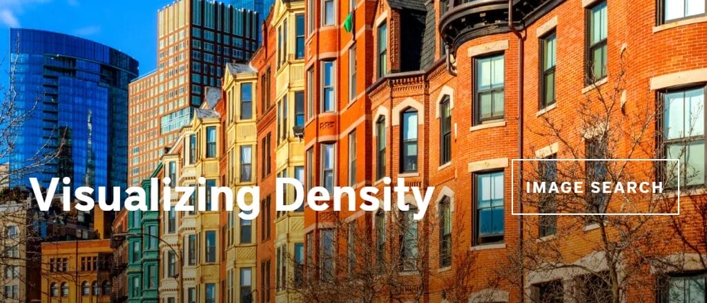
Residential density is understood to be the number of homes within a defined area of land, in the US most often expressed as dwelling units per acre. A typical suburban single-family subdivision might be just two units per acre; a more urban neighborhood, like Boston’s Back Bay, has a density of about 60 units per acre.
Demographic trends suggest that future homeowners and renters will prefer greater density in the form of multifamily housing and mixed-use development, said David Dixon, a vice president at Stantec, a global professional services firm providing sustainable engineering, architecture, and environmental consulting services. Over the next 20 years, the vast majority of households will continue to be professionals without kids, he said, and will not be interested in big detached single-family homes.
Instead they seek “places to walk to, places to find amenity, places to run into friends, places to enjoy community,” he said. “The number one correlation that you find for folks under the age of 35, which is when most of us move for a job, is not wanting to be auto-dependent. They are flocking to the same mixed-use, walkable, higher-density, amenitized, community-rich places that the housing market wants to build … Demand and imperative have come together. It’s a perfect storm to support density going forward.”
Tensions often arise, however, when new, higher density is proposed for existing neighborhoods, on vacant lots or other redevelopment sites. Tim Love, principal and founder of the architecture firm Utile, and a professor at Harvard University’s Graduate School of Design, said he’s seen the wariness from established residents as he helps cities and towns comply with the MBTA Communities Act, a Massachusetts state law that requires districts near transit stations with an allowable density of 15 units per acre.
Some towns have rebelled against the law, which is one of several state zoning reform initiatives across the US designed to increase housing supply, ultimately to help bring prices down.
Many neighbors are skeptical because they associate multifamily density with large apartment buildings of 100 or 200 units, Love said. But most don’t realize there is an array of so-called “gentle density” development opportunities for buildings of 12 to 20 units, that have the potential to blend in more seamlessly with many streetscapes.
“If we look at the logic of the real estate market, discovering over the last 15, 20 years that the corridor-accessed apartment building at 120 and 200 units-plus optimizes the building code to maximize returns, there is a smaller ‘missing middle’ type that I’ve become maybe a little bit obsessed about, which is the 12-unit single-stair building,” said Love, who conducted a geospatial analysis that revealed 5,000 sites in the Boston area that were perfect for a 12-unit building.
“Five thousand times twelve is a lot of housing,” Love said. “If we came up with 5,000 sites within walking distance of a transit stop, that’s a pretty good story to get out and a good place to start.”
Another dilemma of density is that while big increases in multifamily housing supply theoretically should have a downward impact on prices, many individual dense development projects in hot housing markets are often quite expensive. Dixon, who is currently writing a book about density and Main Streets, said the way to combat gentrification associated with density is to require a portion of units to be affordable, and to capture increases in the value of urban land to create more affordability.
“If we have policies in place so that value doesn’t all go to the [owners of the] underlying land and we can tap those premiums, that is a way to finance affordable housing,” he said. “In other words, when we use density to create places that are more valuable because they can be walkable, mixed-use, lively, community-rich, amenitized, all these good things, we … owe it to ourselves to tap some of that value to create affordability so that everybody can live there.”
A fines de la década de 1980, Anne Whiston Spirn lanzó un “proyecto de investigación en acción” diseñado para explorar cómo las pequeñas intervenciones en el paisaje podrían ayudar a restaurar la naturaleza y reconstruir la comunidad en barrios de bajos ingresos en el oeste de Filadelfia. Se suponía que el proyecto duraría cuatro años. Casi cuatro décadas después, el Proyecto de Paisaje del Oeste de Filadelfia (West Philadelphia Landscape Project) sigue vigente, y ha cosechado esperanza y un entendimiento otorgado por la experiencia.
En Mill Creek y otros barrios de Filadelfia, el trabajo conjunto de estudiantes, residentes, paisajistas y otros actores locales creó focos estratégicos de diseño ecológico, por ejemplo, al convertir lotes abandonados en jardines comunitarios y espacios verdes que absorben las inundaciones, y luego vincularon esos proyectos al plan de estudios en las escuelas locales. Este enfoque liderado por la comunidad atrajo la atención nacional. Más cerca de su origen, el programa ayudó a inspirar el plan Green City, Clean Waters (Ciudad Verde, Aguas Limpias) de Filadelfia, a través del cual la ciudad instaló infraestructura verde, como acequias con árboles, jardines pluviales y extensiones con vegetación para aguas pluviales en las aceras en más de 1200 hectáreas de tierras públicas y privadas en toda la ciudad y, de esta forma, se redujo la escorrentía anual de aguas pluviales hacia los cursos de agua locales en más de once mil millones de litros.
En las comunidades históricamente desatendidas, donde los residentes deben tolerar una carga desproporcionada de riesgos climáticos y contaminación, agregar espacios verdes parecería una medida lógica para abordar desigualdades de larga data. Sin embargo, ocurrió algo más cuando el Proyecto de Paisaje del Oeste de Filadelfia tomó impulso. A mediados de la década de 2010, los precios de la vivienda en barrios como Mill Creek comenzaron a subir, al igual que el interés de los inversionistas institucionales, que tienden a aumentar el valor de los alquileres con mayor agresividad que los propietarios que no son inversores, según una investigación del Banco de la Reserva Federal de Filadelfia. Al parecer, todas esas zonas verdes estaban convirtiendo al área más deseable para los inversionistas y más costosa para vivir.
El aumento del valor puede resultar ventajoso para los propietarios de viviendas en barrios que han pasado años sin recibir inversiones, un fenómeno sistemático en las comunidades de color. Pero si bien beneficia a los propietarios, puede ejercer presión de desplazamiento sobre los inquilinos. En ciudades como Atlanta, Baltimore, Charlotte, Filadelfia y Seattle, alrededor de la mitad de las familias son inquilinas, mientras que en ciudades como Boston, Chicago, Los Ángeles y Nueva York esta cifra es de casi dos tercios.
“Me resultó impactante… la rapidez con la que se reemplazaron la desinversión, las plazas disponibles y los edificios abandonados con especulación y desarrollo”, menciona Spirn, que era profesora en la Universidad de Pensilvania cuando comenzó el proyecto en el oeste de Filadelfia y, ahora, enseña en el MIT. “En este momento, las comunidades en las que he trabajado, como Mill Creek, están bajo el asedio de especuladores y desarrolladores”.
Reverdecimiento sin desplazamiento
En un estudio de 28 ciudades norteamericanas y europeas que realizaron grandes inversiones en espacios verdes o adaptación climática entre 1990 y 2016, se concluyó que el reverdecimiento urbano fue un factor principal o contribuyente en el aburguesamiento de diversos sectores de la ciudad en 17 lugares. En Boston, Denver y otras ciudades, el reverdecimiento fue solo un factor que contribuyó al aburguesamiento. En lugares como Atlanta, Copenhague y Montreal, el reverdecimiento urbano se consideró el principal impulsor del aburguesamiento.
Por ejemplo, entre 2011 y 2015, el valor de las viviendas en un rango de 0,8 kilómetros de la vía verde Beltline de Atlanta, un circuito de 35 kilómetros de senderos y parques que conectan 45 barrios de la ciudad, aumentó entre un 18 y un 27 por ciento más que las propiedades en otras partes de la ciudad.
“Hasta que el reverdecimiento urbano sea tan generalizado que no haya un diferencial de precios por su presencia, tendremos que enfrentar el hecho de que es una comodidad a la que la gente responde con una suba de precios”, menciona Amy Cotter, directora de Sostenibilidad Urbana del Instituto Lincoln de Políticas de Suelo.
Existe una fuerte asociación entre los parques y las vías verdes a gran escala y el aburguesamiento, explica James Connolly, profesor asistente de Planificación en la Universidad de Columbia Británica y coautor del estudio de aburguesamiento verde y un documento de trabajo encargado por el Instituto Lincoln. “Es una comodidad muy visible y, al igual que ocurre con cualquier otra comodidad tan visible, como una nueva estación de transporte o un nuevo desarrollo de alto perfil, el reverdecimiento cambia los mercados inmobiliarios de la zona”, indica.
Nueva construcción en el popular circuito Beltline de Atlanta en 2015. Entre 2011 y 2015, el valor de las viviendas en un rango de 0,8 kilómetros de la vía verde de 35 kilómetros aumentó entre un 18 y un 27 por ciento más que las viviendas en otras partes de la ciudad. Crédito: Daniel Lobo vía Flickr.
Los grandes proyectos como parques y vías verdes no son los únicos esfuerzos de reverdecimiento urbano que pueden impulsar el aburguesamiento. Los inversionistas y desarrolladores prestan atención a las inversiones municipales. E incluso las intervenciones más pequeñas, como jardines de lluvia y árboles en la calle, pueden interpretarse como indicios de un cambio cultural o económico.
“Algunas de estas intervenciones de infraestructura verde más pequeñas son solo pequeños jardines de lluvia o elementos ecológicos en la acera”, menciona Connolly; es decir, no significa que los mercados inmobiliarios estén reaccionando a una nueva comodidad de gran envergadura que está cambiando la dinámica de la comunidad. Pero al considerarlas en conjunto, “todas estas intervenciones diferentes pueden comenzar a producir una especie de cambio en la percepción”, agrega Connolly. “En Filadelfia, por ejemplo, podemos ver evidencias, ya que, al sumar las intervenciones de muy pequeña escala, se observa un alto nivel de correlación con los cambios en la dinámica racial y los cambios en el aburguesamiento en la ciudad”.
Todo esto significa que los residentes de comunidades históricamente marginadas pueden desarrollar un escepticismo justificado hacia los nuevos proyectos verdes, incluso cuando las intervenciones tienen la intención de mejorar un barrio o brindarle una mejor protección de los riesgos climáticos como las inundaciones o el calor extremo.
Durante los quince años posteriores a la apertura de Schuylkill River Park en el sur de Filadelfia, la mediana de los precios de las viviendas aumentó un 1.120 por ciento, la residencia en el barrio pasó de ser mayoritariamente negra a ser mayoritariamente blanca, y las instituciones culturales locales, como la Iglesia Bautista New Light Beulah, consideraron necesario cerrar o reubicarse, escriben Sterling Johnson, candidato a doctorado en la Universidad de Temple, y Kimberley Thomas, profesora asociada de Geografía en Temple. “Puede que los términos hayan cambiado desde principios del siglo XX, pero la administración medioambiental sigue pareciendo colonización para muchas personas negras de bajos ingresos”.
Schuykill River Park de Filadelfia en 2011. Entre 2000 y 2014, el valor de las viviendas en el área aumentó un 1.120 por ciento a medida que aumentaron el desarrollo y la propiedad de los inversionistas. Crédito: aimintang/iStock No publicado a través de Getty Images.
Y en Detroit, alrededor de una cuarta parte de los residentes se negaron a aceptar árboles gratuitos en las calles frente a sus casas: no por no entender los beneficios del dosel de árboles, sino debido a la persistente desconfianza en la ciudad, según un estudio realizado por Christine Carmichael, en ese momento, en la Universidad de Vermont.
Si las ciudades no reconocen y tratan con seriedad el potencial de desplazamiento causado por las intervenciones ecológicas, agrega Connolly, “lo que logramos es un apoyo político muy reducido para el reverdecimiento urbano, ya que muchas personas terminan pensando que no tiene sentido apoyarlo porque no está dirigido a ellas”.
Formulación coordinada de políticas
La tensión entre el reverdecimiento urbano destinado a mejorar la calidad de vida y el desplazamiento económico que suele resultar es un problema que exige una planificación y formulación coordinadas de políticas. “No se puede tener seguridad residencial a expensas de la seguridad medioambiental, y no se puede tener seguridad medioambiental a expensas de la seguridad residencial”, explica Connolly. “Estos dos elementos no son negociables entre sí: ambos son necesarios”. También señala que el reverdecimiento urbano no siempre conduce al desplazamiento; en casi la mitad de las ciudades estudiadas, el impacto de el reverdecimiento en el aburguesamiento fue leve o nulo.
Una ciudad puede usar diversas herramientas de política específicas para ayudar a mitigar el desplazamiento al reverdecer un barrio. De hecho, las soluciones son similares al margen de la causa de la presión del desplazamiento, pero deben aplicarse en conjunto con las intervenciones verdes (o incluso antes).
Los fideicomisos de suelo comunitarios, por ejemplo, pueden ayudar a los residentes a obtener participación en la propiedad del barrio y garantizar la capacidad de pago permanente de la vivienda. Las medidas de estabilización de alquileres pueden controlar los aumentos de los precios del alquiler, por lo que los inquilinos no deben abandonar la comunidad por cuestiones de precio. Las leyes de “oportunidad de compra”, como las de Washington, DC, permiten que los inquilinos o las ciudades tengan prioridad para comprar una casa si un propietario decide vender. La zonificación inclusiva, los requisitos de vivienda asequible, las tarifas de los desarrolladores y otras herramientas también pueden ayudar a aliviar la presión del desplazamiento.
“No es solo un elemento, sino un conjunto de herramientas”, explica Isabelle Anguelovski, profesora de investigación de la Universidad Autónoma de Barcelona y directora del Laboratorio de Barcelona para la Justicia Medioambiental Urbana y la Sostenibilidad (BCNUEJ), coautora del estudio y documento de trabajo sobre el aburguesamiento junto con Connolly.
“Depende tanto de los impuestos como de los incentivos”, continúa. “Vancouver tiene un impuesto a las viviendas vacías. Algunos estados, como Washington, tienen control de alquileres a un nivel estatal más amplio. Portland, Oregón, implementó lo que se denomina política de “derecho al retorno”, que está dirigida a residentes que sufrieron desplazamiento debido al aburguesamiento en las últimas décadas o la renovación urbana en la década de 1960”.
Se pueden aplicar otros impuestos y tarifas para desarrolladores a fin de construir viviendas sociales, generar subsidios para el alquiler o apoyar a pequeños comercios minoristas locales que, de lo contrario, podrían verse obligados a abandonar la comunidad que habitan hace un largo tiempo por cuestiones de precio. “A nivel local, si los impuestos se asignan con claridad de la manera correcta, las ciudades pueden usar esos fondos para comprar terrenos vacantes o edificios abandonados y transformarlos en viviendas sociales y públicas”.
Mientras tanto, los incentivos pueden tomar la forma de bonificaciones de densidad, que permiten que los desarrolladores construyan estructuras más altas de lo que se permite con la condición de que se reserven más unidades para viviendas con ingresos limitados, por ejemplo, el 30 por ciento del edificio. “A menudo, los municipios no logran obtener más del 10 o 15 por ciento”, según Anguelovski. “Sin embargo, es el turno de las ciudades en crecimiento que son atractivas para los desarrolladores. Así que no deberían tener miedo de ejercer presión sobre ellos, ya que son ciudades que tienen diversas comodidades que la gente busca”.
Reverdecimiento dirigido por la comunidad con intención de colaboración
Ninguna de estas intervenciones de desplazamiento es particularmente misteriosa o difícil de implementar, menciona Cotter. Pero hacerlo bien requiere la colaboración entre agencias que no suelen trabajar juntas: “La tarea del silvicultor urbano no es pensar en la estabilización de los alquileres”.
Es por eso que Connolly y Anguelovski, que presentaron una investigación para un próximo informe de enfoque en políticas en un taller del Instituto Lincoln en junio, indican que es esencial que las ciudades adopten un enfoque coordinado e intersectorial para el reverdecimiento. Incluso si el departamento de parques o la comisión de agua está tomando la iniciativa en una intervención ecológica en particular, explica Connolly, el esfuerzo también debería involucrar a otros departamentos clave de la ciudad, de modo que “la infraestructura ecológica se implemente con un plan de infraestructura de vivienda y transporte integrados”.
Barcelona demostró que este enfoque es posible, y quizás perfecto, durante la alcaldía de Ada Colau, indica Connolly. “Desde la oficina del alcalde, ordenaron que muchas de las agencias comenzaran a tener más conversaciones transversales sobre cómo la planificación de recursos existente se integra con otras dimensiones del gobierno y otras operaciones de la ciudad”, agrega Connolly.
Los residentes celebran la apertura de una supermanzana en Barcelona en 2023. La ciudad coordinó este ambicioso esfuerzo de sostenibilidad urbana entre múltiples agencias y aseguró la integración de la planificación y los recursos. Crédito: Ajuntament Barcelona vía Flickr.
“Es necesario intentar, en la medida de lo posible, evitar que estos dos elementos entren en conflicto, evitar que los desarrollos de la agencia de reverdecimiento dificulten que se alcancen las medidas de capacidad de pago de la vivienda”, agrega. “Solo se trata de debatir los dos temas en conjunto, lo que no significa rechazar la capacidad de pago de las viviendas ni rechazar el reverdecimiento: significa realizar esto de forma coordinada, además de incorporar elementos como apoyos sociales e infraestructura de transporte, entre otros… No digo que sea simple. Pero Barcelona tomó buenas medidas en pos de esto”.
Otro cambio más grande, casi filosófico, que Connolly cree que las ciudades deberían lograr es alejarse de un enfoque “oportunista” de el reverdecimiento, en el que las ciudades con objetivos climáticos o medioambientales específicos aprovechan cualquier oportunidad que tengan para agregar intervenciones verdes para avanzar en esos objetivos. Si existe la oportunidad de plantar algunos árboles o ponerlos en algún parque, lo hacen por reflejo, explica Connolly. “Pero esas oportunidades se crean por ciertas razones que, en general, están asociadas con el desarrollo. Entonces, si solo se tiene un enfoque oportunista para el reverdecimiento, siempre se vinculará el reverdecimiento con estos ciclos de desarrollo y ahí radica un desafío”. En cambio, recomienda adoptar un enfoque más intencional y general. “Incluso si no hay una oportunidad para el reverdecimiento, ¿cómo podemos crearla por nuestra cuenta?”.
Spirn, del Proyecto de Paisaje del Oeste de Filadelfia, que ha pasado gran parte de los últimos cinco años trabajando con sus alumnos en estrategias para prevenir el desplazamiento relacionado con el reverdecimiento urbano, está de acuerdo: “Es muy importante empezar a pensar en cómo ayudar a las personas a permanecer en sus hogares antes de comenzar a construir nuevos proyectos de infraestructura verde”, concluye. Y agrega que cualquier estrategia que una ciudad emplee en este sentido debe centrarse en los residentes. “La infraestructura verde debe ser algo más que el reverdecimiento. Tiene que tratarse de las personas”.
A algunos les preocupa que este enfoque, el reverdecimiento con más intención y con más aportes e intervención de los residentes empoderados de la comunidad, no pueda seguirle el ritmo a la urgencia de la crisis climática. “Existe la preocupación de que ser equitativos y respetar la autodeterminación implicará una peligrosa ralentización, y lo entiendo, pero también rechazo esa suposición”, indica Cotter. “Es un imperativo de la equidad que abordemos el cambio climático lo más rápido posible, porque las personas que más sufrirán son las poblaciones que siempre quedan marginadas, las mismas personas cuya autodeterminación y participación se ha visto socavada por los sistemas de racismo estructural”.
Si las comunidades pueden liderar la toma de decisiones frente al cambio climático, continúa Cotter: “No creo que sean más lentas. Creo que tendrían una perspectiva clara de lo que debe suceder, lo harían más rápido y encontrarían soluciones que en verdad reflejen las condiciones y las necesidades locales”.
Jon Gorey es redactor del Instituto Lincoln de Políticas de Suelo.
Imagen principal: Una calle residencial en el oeste de Filadelfia.Crédito:Ciudad de Filadelfia.
Lincoln Institute of Land Policy and Land Trust Alliance Present Hudson Valley’s Steve Rosenberg with Kingsbury Browne Distinguished Practitioner Award
The Kingsbury Browne Distinguished Practitioner award—named for Kingsbury Browne, a lawyer and conservationist who was a Lincoln Institute Fellow in 1980 and inspired the Alliance’s founding in 1982—is presented annually and honors those who have enriched the conservation community through their outstanding leadership, innovation, and creativity in land conservation. Rosenberg will serve as the Kingsbury Browne distinguished practitioner for the Lincoln Institute in Cambridge, Massachusetts, for 2025–2026.
Rosenberg is currently the co-convener of the Hudson Valley Alliance for Housing and Conservation, which brings together organizations to strengthen biodiversity and climate resilience in New York’s Hudson Valley while creating affordable places where people can live. His work there follows more than three decades as the senior vice president of Scenic Hudson and the executive director of the Scenic Hudson Land Trust, where he led many efforts bringing land, equity, and conservation together at the regional scale, including authoring the NYC/Hudson Valley Foodshed Conservation Plan, launching Scenic Hudson’s River Cities Program, and transforming postindustrial Hudson River waterfronts into inviting public places. Rosenberg served on the board of the Land Trust Alliance for nine years.
“Steve has been a driving force in putting conservation to work for communities—safeguarding local food systems, expanding land access, and advancing economic opportunity,” said Chandni Navalkha, director of conservation and stewardship at the Lincoln Institute. “His leadership in uniting the land conservation and affordable housing sectors in the Hudson Valley sets a powerful example for collaborative solutions that benefit people and places, nationwide and beyond.”
“I have witnessed firsthand Steve’s passion and tireless dedication to land conservation and the mutually reinforcing benefits to people and communities,” said Ashley Demosthenes, CEO of the Land Trust Alliance. “The acreage protected and parks that were created during his tenure at Scenic Hudson are tremendous assets for communities and the entire Hudson Valley. And his bringing together of the affordable housing community and the land preservation community has made it possible to address critical community issues in new and collaborative ways. It is my honor to recognize Steve Rosenberg as the recipient of the 2025 Kingsbury Brown Distinguished Practitioner award.”
About the Land Trust Alliance
Founded in 1982, the Land Trust Alliance is a national land conservation organization working to save the places people need and love by empowering and mobilizing land trusts in communities across America to conserve land for the benefit of all. The Alliance represents approximately 1,000 member land trusts and affiliates supported by more than 250,000 volunteers and 6.3 million members nationwide. The Alliance is based in Washington DC, with staff in communities across the United States.
About the Lincoln Institute of Land Policy
The Lincoln Institute of Land Policy seeks to improve quality of life through the effective use, taxation, and stewardship of land. A nonprofit private operating foundation whose origins date to 1946, the Lincoln Institute researches and recommends creative approaches to land as a solution to economic, social, and environmental challenges. Through education, training, publications and events, we integrate theory and practice to inform public policy decisions worldwide.
Lead image: Steve Rosenberg (center) accepts the Kingsbury Browne award alongside Land Trust Alliance CEO Ashley Demosthenes (right) and board chair David Calle (left). Credit: DJ Glisson II/Firefly Imageworks.
Heirs Property and Disaster Relief Preparedness
Registration Deadline:
October 31, 2025 at 11:59 PM
The Lincoln Institute of Land Policy invites proposals for original research that explores the intersection of heirs property and disaster preparedness. We are particularly interested in research that studies the issue of tangled titles and how communities have tried to address them in preparing for natural disasters.
We will look for case studies on this issue that identify specific problems related to heirs property and ask what strategies are being taken to prepare for and respond to climate-related disasters. The case studies produced from this request for proposals (RFP) will be used to inform further research in addition to contributing to research-informed practice.
Situations case studies can focus on include:
Cases of natural disaster risk that heirs property communities are experiencing
Instances where heirs property communities stay informed and prepare for these disasters. Examples of resources, social or public support structures in a community.
Financing measures (e.g. land-based finance) in local communities or among practitioners.
Questions case studies may explore include, but are not limited to:
How do practices differ between types of natural disasters? Are these strategies and tactics replicable and practices scalable?
What policy interventions do heirs property communities need from state and federal agencies for their strategies to be the most effective?
Details
Registration Deadline
October 31, 2025 at 11:59 PM
Keywords
Climate Mitigation
Graduate Student Fellowships
2025–2026 Programa de becas para el máster UNED-Instituto Lincoln
Registration Deadline:
October 10, 2025 at 11:59 PM
El máster está dirigido especialmente a estudiantes de posgrado y otros graduados con interés en políticas urbanas desde una perspectiva jurídica, ambiental y de procesos de participación, así como a funcionarios públicos. Los participantes del programa recibirán el entrenamiento teórico y técnico para liderar la implementación de medidas que permitan la transformación sostenible de las ciudades.
Plazo de matrícula ordinario: del 8 de septiembre al 28 de noviembre de 2025
El inicio del máster es en enero de 2026. La fecha exacta se anunciará antes del 28 de noviembre de 2025.
El Instituto Lincoln otorgará becas que cubrirán parcialmente el costo del máster de los postulantes seleccionados.
Términos de las becas:
Los becarios deben haber obtenido un título de licenciatura de una institución académica o de estudios superiores.
Los fondos de las becas no tienen valor en efectivo y solo cubrirán el 40 % del costo total del programa.
Los becarios deben pagar la primera cuota de la matrícula, que representa el 60 % del costo total del máster.
Los becarios deben mantener una buena posición académica o perderán el beneficio.
El otorgamiento de la beca dependerá de la admisión formal del postulante al máster UNED-Instituto Lincoln.
Si son seleccionados, los becarios recibirán asistencia virtual para realizar el proceso de admisión de la Universidad Nacional de Educación a Distancia (UNED), el cual requiere una solicitud online y una copia del expediente académico o registro de calificaciones de licenciatura y/o posgrado.
Aquellos postulantes que no obtengan la beca parcial del Instituto Lincoln podrán optar a las ayudas que ofrece la UNED, una vez que se hayan matriculado en el máster.
Fecha límite para postular: 10 de octubre de 2025, 23:59 horas de Boston, MA, EUA (UTC-5)
Anuncio de resultados: 22 de octubre 2025
Details
Registration Deadline
October 10, 2025 at 11:59 PM
Keywords
Climate Mitigation, Development, Dispute Resolution, Environmental Management, Exclusionary Zoning, Favela, Henry George, Informal Land Markets, Infrastructure, Land Market Regulation, Land Speculation, Land Use, Land Use Planning, Land Value, Land Value Taxation, Land-Based Tax, Local Government, Mediation, Municipal Fiscal Health, Planning, Property Taxation, Public Finance, Public Policy, Regulatory Regimes, Resilience, Reuse of Urban Land, Urban Development, Urbanism, Value Capture
Webinar and Event Recordings
Land Use and Transportation Scenario Planning in Greater Boston
The Consortium for Scenario Planning is hosting a peer exchange featuring Sarah Philbrick and Conor Gately from the Metropolitan Area Planning Council (MAPC), who will discuss their summer 2025 project conducting four land use scenarios using a travel demand model to understand the impact of different transit-oriented development (TOD) strategies on greenhouse gas (GHG) emissions in Greater Boston.
Local and regional planners, metropolitan planning organizations (MPOs), professionals, and community members interested in learning more about land use and transportation planning and how TOD strategies impact GHG emissions are invited to tune in to this webinar. Simultaneous English-Spanish translation will be available via Zoom. If you would like to use the translation service, please join the webinar five minutes early.
Speakers
Sarah Philbrick
Research Manager, MAPC
Conor Gately
Senior Land Use and Transportation Analyst, MAPC
Details
Date
October 16, 2025
Time
12:00 p.m. - 1:00 p.m. (EDT, UTC-4)
Registration Period
August 19, 2025 - October 16, 2025
Language
English
Keywords
Infrastructure, Land Use, Land Use Planning, Pollution, Scenario Planning, Transport Oriented Development