The Lincoln Institute’s 2022 Journalists Forum brought together 30 reporters and editors on the climate beat for two days of conversation about the role of land in the climate crisis, highlighting the need for new ideas, innovations, and policies to help head off the worst impacts of global warming.
Land and land policy thread through just about every aspect of the crisis, whether deforestation, land conservation for carbon sequestration, the interplay of land, water, and agriculture, or the fact that usable land is disappearing, raising the important question of where millions of displaced people will go, now and in the future.
Meanwhile, powerful private market actors are at work, in many cases swooping in and buying land that will be prime and prized as flooding, wildfire, mudslides, and sea-level rise make other locations unlivable—a classic case of real estate speculation.
“We need to elevate . . . the understanding of the important role that land plays and will play in our ability to address this existential crisis. And if we get it wrong, we’’re going to leave a planet that’s very, very different for whomever is left to exist on it,” said George W. McCarthy, president of the Lincoln Institute, in this collection of highlights from the forum for the Land Matters podcast.
“And the big question is, are we prepared to? And can we navigate between the really, really powerful claims, private claims over dominion over land in exchange for the collective needs to use land differently to get to better global outcomes?” McCarthy asked. “Everything hangs in the balance.”
The journalists considered the intense competition for land, with the siting of solar and wind facilities, transmission pipelines, and other needs in the transition to net-zero emissions; emerging strategies in agriculture and the management of dwindling water resources; and current practices in land conservation, which make it possible for natural areas to continue to soak up carbon.
They also heard about how land can be used to pay for climate action, through land value capture—the harnessing of a portion of increases in private land values triggered by government investments in infrastructure—and the need for more coherent climate migration policies that take into account the vulnerable populations being forced to move from their homes.
The Journalists Forum also featured some practical tools to help cover the story of the century, led by Jeff Allenby of the Center for Geospatial Solutions and Peter Colohan from the Internet of Water initiative, both new Lincoln Institute programs. Advances in technology have enabled a real-time monitoring of land use changes and water flows, which serves as a critical foundation for planners and policymakers — and journalists for telling the story of this turbulent time.
The convening also included a discussion of the business of climate journalism itself, led by Nancy Gibbs, director of the Shorenstein Center on Media, Politics and Public Policy at Harvard’s Kennedy School; Andrew McCormick from the collaborative Covering Climate Now, Amrita Gupta from the Earth Journalism Network, and Trish Wilson, who established the first climate team dedicated to coverage of global warming at the Washington Post.
Anthony Flint is a senior fellow at the Lincoln Institute of Land Policy, host of the Land Matters podcast, and a contributing editor of Land Lines.
Graduate Student Fellowships
2022–2023 Programa de becas para el máster UNED-Instituto Lincoln
Registration Deadline:
November 29, 2022 at 11:59 PM
SHARE
El Instituto Lincoln de Políticas de Suelo y la Universidad Nacional de Educación a Distancia (UNED) ofrecen el máster en Políticas de Suelo y Desarrollo Urbano Sostenible, un programa académico en español que tuvo gran demanda en su primera convocatoria. Se trata de un posgrado que reúne de manera única los marcos legales y herramientas que sostienen la planificación urbana, junto con instrumentos fiscales, ambientales y de participación sostenibles, todo desde una perspectiva internacional y comparada.
El máster en Políticas de Suelo y Desarrollo Urbano Sostenible es un programa en formato virtual y se compone de cuatro módulos, los cuales abordan una parte importante de la realidad actual de las ciudades: el derecho administrativo urbano, el financiamiento con base en el suelo, el cambio climático y el desarrollo sostenible, y el conflicto urbano y la participación ciudadana. El programa académico concluye con un trabajo final de máster que permite a los alumnos trabajar de cerca con actividades de desarrollo urbano actuales, como el proyecto Castellana Norte en Madrid.
El programa está dirigido especialmente a estudiantes de posgrado y otros graduados con interés en políticas urbanas desde una perspectiva jurídica, ambiental y de procesos de participación, así como a funcionarios públicos. Los participantes del máster recibirán el entrenamiento intelectual y técnico para liderar la implementación de medidas que permitan la transformación de las ciudades.
El Instituto Lincoln otorgará becas que cubrirán parcialmente el costo del máster de los postulantes seleccionados.
Términos de las becas
Los becarios deben haber obtenido un título de licenciatura de una institución académica o de estudios superiores.
Los fondos de las becas no tienen valor en efectivo y solo cubrirán el 40% del costo total del programa.
Los becarios deben pagar la primera cuota de la matricula que representa el 60% del costo total del máster.
Los becarios deben mantener una buena posición académica o perderán el derecho a la beca.
El otorgamiento de la beca dependerá de la admisión formal del postulante al máster UNED-Instituto Lincoln.
Si son seleccionados, los becarios recibirán asistencia virtual para realizar el proceso de admisión de la Universidad Nacional de Educación a Distancia (UNED), el cual requiere una solicitud online y una copia de su expediente académico o registro de calificaciones de licenciatura y/o posgrado.
Aquellos postulantes que no obtengan la beca parcial del Instituto Lincoln podrán optar a las ayudas que ofrece la UNED, una vez que se hayan matriculado en el máster.
Fecha límite para postular: 29 de noviembre de 2022, 23:59 horas de Boston, MA, EE.UU. (UTC-5)
Anuncio de resultados: 16 de diciembre de 2022
Details
Registration Deadline
November 29, 2022 at 11:59 PM
Keywords
Climate Mitigation, Development, Dispute Resolution, Environmental Management, Favela, Henry George, Informal Land Markets, Infrastructure, Land Market Regulation, Land Speculation, Land Use, Land Use Planning, Land Value, Land Value Taxation, Land-Based Tax, Local Government, Mediation, Municipal Fiscal Health, Planning, Property Taxation, Public Finance, Public Policy, Regulatory Regimes, Resilience, Reuse of Urban Land, Urban Development, Urbanism, Value Capture, Zoning
Events
Consortium for Scenario Planning 2023 Conference
February 1, 2023 - February 3, 2023
Phoenix, AZ United States
Offered in English
SHARE
The Consortium for Scenario Planning will host its sixth annual conference in Phoenix, Arizona, in early February. Focused on new and current scenario planning projects, the in-person conference will showcase scenario planning work around the country. Download the complete agenda and a list of presenters.
In the wake of a pandemic, extreme weather events, and economic instability, scenario planning continues to be an invaluable tool for cities and regions as they prepare for an uncertain future. Practitioners, consultants, and academics will present cutting-edge advances in the use of scenarios to address many trends affecting communities large and small. Conference sessions will be eligible for AICP Certification Maintenance credits.
Register today to reserve your space, and reserve a hotel room as soon as possible once you are registered. The registration fee is $300, but discounts are available (see the registration form for details).
Please share this opportunity with your colleagues and contact Heather Hannon, Associate Director of Planning Practice and Scenario Planning with questions.
Details
Date
February 1, 2023 - February 3, 2023
Location
David C. Lincoln Conference Center Phoenix, AZ United States
Adaptation, Climate Mitigation, Disaster Recovery, Economic Development, Environmental Planning, Farm Land, Floodplains, GIS, Infrastructure, Intermountain West, Job Sprawl, Land Use, Land Use Planning, Local Government, Mapping, Planning, Public Policy, Regionalism, Resilience, Scenario Planning, Smart Growth, Transportation, Urban Development, Urban Sprawl, Urbanism, Water Planning, Zoning
Demands on the Land: To Secure a Livable Future, We Must Steward Land Wisely
By Sivan Kartha, July 27, 2022
SHARE
SINCE THE WORLD FIRST NEGOTIATED A CLIMATE TREATY in 1992, three precious decades have ticked by while we’ve allowed a climate challenge to evolve into a climate crisis. The latest assessment from the Intergovernmental Panel on Climate Change, released this spring, eschewed the moderate language of the staid scientific body, making it clear that society faces an urgent crisis and must take action. That report represents “a litany of broken climate promises,” said UN Secretary General António Guterres. “It is a file of shame, cataloguing the empty pledges that put us firmly on track toward an unlivable world.”
At last year’s UN Climate Summit in Glasgow, the nations of the world doubled the emissions reductions they had previously promised for this decade, but we actually need a fivefold enhancement of those goals. As things stand now, we can emit only about 300 billion tons of carbon dioxide (GtCO2) before global temperatures are expected to exceed the 1.5 degrees Celsius identified in the Paris Agreement as the upper limit of acceptable warming. If countries fail to cut emissions far beyond what they’ve promised so far, the world will exceed that 300 billion tons within this decade. That will lead us toward chaos far greater than the unparalleled storms, droughts, wildfires, and displacements the globe is already experiencing.
It’s well within our capabilities to dramatically cut emissions. We know which renewable energy technologies and energy-efficient practices we need to deploy widely, we know that protecting ecosystems and other species supports our own ability to thrive, and we’re equally aware of the exceedingly wasteful and fossil fuel–intensive agricultural practices and land-intensive diets that we need to alter.
As it turns out, land figures prominently in many of our most promising climate solutions, and is thus central to many of the tensions and trade-offs we must now deftly navigate. Having pushed the clock to the limit, we must find a way to avoid moving forward haphazardly, running roughshod over fundamental ecological and human needs in a mad dash for “climate-friendly” solutions. Stewarding land wisely while we face an increasingly hostile climate will prove critical to securing a livable future.
EVEN WHILE LAND IS INCREASINGLY STRESSED BY A CHANGING CLIMATE, it will face rising and conflicting demands from human society in our pursuit of both climate solutions and sanctuary from a more hostile climate. Let’s lay out the main aspects of this contested landscape.
Land will be required to sustain species and ecosystems that are increasingly threatened by climate change to the point of extinction or collapse. Earth is currently undergoing its sixth mass extinction since the Cambrian explosion half a billion years ago. Writing of the evolutionary tree of life, Elizabeth Kolbert, a scholar of such extinctions, explains: “During a mass extinction, vast swathes of the tree are cut short, as if attacked by crazed, axe-wielding madmen” (Kolbert 2014). Even as a metaphor, this may be an understatement, as we now also have bulldozers, big dams, and other even less judicious means of directly appropriating land from natural ecosystems.
As human-caused climate change accelerates, it will overtake our appropriation of land as the top driver of the ongoing extinction (IPCC WGII 2022). A report from the Intergovernmental Science-Policy Platform on Biodiversity and Ecosystem Services found that more than a million species are threatened with extinction, many in the next few decades (IPBES 2019). Sustaining the natural ecosystems on which human survival depends—from the mountainous snowpack from which rivers run year-round to the rich soils in which our food grows to the coral reefs that sustain coastal fisheries—ultimately will rest on our ability to reduce and reverse our appropriation and fragmentation of natural habitat, all while we stop fueling climate change.
As a critical first step, nearly 100 countries comprising the High Ambition Coalition for Nature and People have called for a global 30×30 deal to protect 30 percent of the world’s land and oceans by 2030. This ambitious effort aims to halt biodiversity loss and preserve ecosystems, with the added benefits of supporting economic security and a stable climate. Today, only about 15 percent of our land and 7 percent of our oceans is protected.
Land will be required to resettle people displaced by flooding, extreme weather, and climatic shifts that render currently inhabited areas no longer hospitable. We know the climate and weather extremes that are already driving displacement will escalate. The World Bank estimates that more than 200 million people will be forced from their homes by climate change in Asia, Africa, and Latin America in the next few decades, and millions more will be affected in other regions. This climate-induced dislocation and involuntary migration will amplify existing stressors such as conflict, food and water insecurity, poverty, and loss of livelihoods from economic or environmental pressures (IPCC WGII 2022).
In other words, marginalized and disempowered households and communities will invariably suffer the worst consequences, which will with rising frequency rise to the level of humanitarian and human rights crises. Any effort to manage these situations humanely will have implications for human settlements and the habitable land that they require. Resettlement will require far less land than other demands—one estimate suggests 0.14 percent of the planet (somewhat less than the area of the United Kingdom) could absorb 250 million climate migrants (Leckie 2013). Yet the mass climate migration already underway represents a significant shift in how and where people occupy and use land, and should be a priority for efforts to secure and preserve human rights for migrants and refugees.
Land will be required to feed our expanding global population, even as some regions face declines in water, increases in pests, and diminishing soil fertility. Climate change has slowed the growth in food productivity that was seen over the last decade, and climate-related extreme events have exposed millions of people to acute food insecurity and undermined water security.
A worsening climate will heighten these threats—which are, once again, cruelly directed at those who are marginalized and disempowered. Agriculture constitutes the primary human pressure on the global landscape; estimates suggest that it has already led to the clearing or conversion of 70 percent of global grassland, 50 percent of savanna, 45 percent of the temperate deciduous forest, and 27 percent of tropical forests. Agriculture also affects water bodies through drainage and chemical runoff, and emits greenhouse gases and pollutants into the atmosphere.
Agricultural approaches founded on principles of biodiversity and ecosystem regeneration are being increasingly proven and scaled, and have the potential to help combat climate change, even with a growing global population. Likewise, major changes to our global food system that prioritize human rights, and that reduce meat consumption and food waste, can dramatically expand and deepen food security. A staggering share of global plant crops is eaten by livestock rather than people. More than one-third of all calories and more than one-half of all protein from agricultural crops goes to feed animals, with only a small share ultimately becoming nourishment for people. The consumption of meat is specifically charged with causing the continuing spike in deforestation of the Amazon rainforest, a biome that comprises 40 percent of the world’s rainforest and serves as home to 25 percent of its remaining terrestrial species.
Sheep and solar panels share space on a farm in Germany. Credit: Karl-Friedrich Hohl via E+/Getty Images.
Land will be called on as a site for the energy sources—primarily solar power, wind power, and biopower—needed to replace the fossil fuels that now meet five-sixths of global energy demand. Solar and wind power, while they have undeniable impacts on the landscape, can be situated in areas suited for multiple uses; for example, wind turbines and solar panels can be sited on farmland or in urban spaces like rooftops and parking lots. Unlike solar and wind power, bioenergy—which is produced using agricultural feedstocks, in the form of either electricity (biopower) or fuels (biofuels)—must be sited on agriculturally productive land. At any significant scale, bioenergy competes with food production.
Consider the following: total cropland globally amounts to less than half an acre per person, yet it already puts considerable pressure on water, soil, and other ecological resources. Even if we posit a quite efficient process for producing and using biofuel (in contrast to the U.S. approach of burning corn-based ethanol in conventional combustion vehicles), more than 1.2 acres would be needed to keep a single passenger vehicle fueled. An efficient biopower plant would fare hardly any better, claiming roughly 0.8 acre per capita to grow the fuel needed to generate the electricity used by the average United States resident. By contrast, solar photovoltaics require less than 5 percent of one acre per person or, for the whole U.S. population, a bit less than 15 million acres. This is not a trivial footprint, but it’s worth noting that in 2017 alone, federal land leases offered for oil and gas production in the United States amounted to more than 12 million acres.
To put it plainly, bioenergy would function for the typical high-energy consumer just as meat functions for the typical high-meat consumer—it would allow them to consume vastly more land than they would if they simply used that land’s output directly. By extension, it would also enable the world’s over-consumers to compete even more ruthlessly with the world’s poor for the resources that underpin survival, like food, livelihoods, and homes.
Land will be called upon to “negate” our carbon excesses by removing accumulated carbon dioxide from the atmosphere. The world’s lands serve as an enormous carbon sink, with plants and soil absorbing about a quarter of our excess carbon dioxide from the atmosphere. (Another quarter of our excess carbon emissions is absorbed by the oceans; the remaining one-half accumulates in the atmosphere and is responsible for warming the planet.) Deterioration of an ecosystem—such as by climate-induced pests, drought, fire, and deliberate human modification—diminishes its capacity to absorb carbon, and may even convert it into a source of carbon dioxide emissions. Unchecked climate change could disrupt climatic conditions enough to send a region like the Amazon rainforest across such a tipping point—converting it from a carbon sink to a carbon source—and in fact, just such a weakening of resilience is already being observed there (Boulton, Lenton, and Boers 2022).
Despite the threats that climate change poses to natural carbon absorption, it is increasingly held out as an alternative to reducing our own emissions, or at least as a crafty expedient whereby we can buy some time, relax the mitigation burden a bit, and more gradually ramp up our emissions reduction efforts over a longer timeframe. Indeed, the hopes for these “negative emissions” strategies have grown beyond reasonable expectations.
Some analysts of future mitigation options assume the removal of carbon dioxide from the atmosphere and storage of it on the land (in the form of plant or soil matter) or underground (as compressed carbon dioxide transported in pipelines) will grow to a scale comparable in land requirements to current global agriculture.
If we cooperated globally and worked strenuously to keep emissions within the 1.5-degree Celsius budget, viewing negative emissions as a possible solution for situations that were virtually impossible to address any other way (such as methane emissions from wetland rice cultivation) would be feasible and sensible. But instead, most countries have charted a slow pace of reduction efforts for the near term and inadequate reduction targets for the medium term; they have labeled these steps consistent with the Paris goals, presupposing a vast reserve of land will wondrously materialize for negative emissions duty when we need it. This is a reckless strategy. Pursuing it further means banking on land being available and hoping that negative emissions activities won’t conflict with social needs such as food security.
Because the world has willfully downplayed the near-term effort needed to keep climate change within manageable bounds, such a strategy could leave us—and future generations—stranded with an insufficiently transformed energy economy. Saddled with a fossil fuel–dependent energy infrastructure, society would face a much more abrupt and disruptive transition than the one it had sought to avoid. Having exceeded its available carbon budget, it would face a carbon debt that cannot be repaid, and ultimately see much greater warming than it had prepared for.
WISE LAND USE AND STEWARDSHIP WILL PROVE CRITICAL to navigating our future. The specific technologies, practices, and policies are enormously varied and context specific, so it would be foolish to attempt a fair treatment here. But a few broad observations are warranted.
First, several cases touched on above illustrate how society is increasingly relying on land resources to help deal with climate change, even while land is itself under rising stresses from climate change. The expected tensions and trade-offs are already testing society’s capacity for wise land stewardship in a more hostile climate, with mixed results.
As biodiversity loss accelerates, there is increasing recognition that a large share of remaining biodiversity-rich areas—including more than one-third of intact forests and 80 percent of the world’s terrestrial biodiversity—is in the hands of indigenous groups. These stewards have protected both biodiversity and forest carbon more successfully than others, even during decades of rapacious extraction of global forest resources (Fa et al. 2020; World Bank 2019). This understanding must now be translated into policies that legally recognize and actively enforce community-based land tenure rights consistent with the UN Declaration on the Rights of Indigenous People, which most indigenous communities do not yet enjoy. Where that is done, indigenous communities will be better able to protect common resources through locally appropriate collective action. They will also be better able to resist outside actors who are intent on either extracting and degrading forest resources or on imposing “fortress conservation” models that disregard indigenous rights and are less effective in their ostensible conservation aims.
Much the same lesson applies to a range of emerging “green grab” strategies. As pressure on land is intensified by growing demand for bioenergy and food production, negative emissions capacity, and habitable areas, those who have capital, flexibility, political savvy, and powerful networks are crafting the relevant policies and ultimately benefiting from them, including through speculation. Consequently, the cost of public efforts to meet collective needs escalates, preventing people with the least political or economic power from meeting basic needs like food, livelihood, and home. New ways of abstracting these components of land and ecosystems and integrating them into distantly removed market processes are legitimizing new forms of appropriation. Some of them are akin to financial derivatives, and indeed can be disconcertingly reminiscent of the mortgage-backed financial derivatives, the collapse of which brought on a global recession and threatened much worse. One particularly glaring example is the carbon offset program (the Clean Development Mechanism) that developed countries have used to meet their legally binding targets under the Kyoto Protocol. This mechanism is now understood to have been based overwhelmingly on fictitious greenhouse gas reductions.
We should thus be wary about market mechanisms that simply carry forward questionable assumptions of equivalence (among distinct bits of natural capital) or of fungibility (between natural resources and technical alternatives), and about policy regimes that privilege the idea of net economic welfare to rationalize probable casualties of distribution or outright injuries to human rights and justice.
AS SPECIFIC CHARACTERISTICS OF LAND and ecosystems—such as their promise as a carbon sink or suitability for energy production—become more highly valued and more tightly integrated into the global economy, a fundamental question becomes only more pressing: who controls land and who benefits from it?
Lincoln Institute President George McCarthy put it succinctly at the organization’s Journalists Forum on climate change this spring: “Land contention redounds to power. And in disputes, power wins.” If the very power structures at the root of climate change are left intact, then the resulting market mechanisms and policy interventions will fail to save the climate while worsening the global scourge of poverty and marginalization. In doing so, they can contribute to what is becoming the third injustice of climate change: the most vulnerable are not only the least responsible for and most affected by climate change, but also the frontline victims of ill-conceived climate policies.
Our global society is confronting risks of an existential magnitude. These risks—all of our own making—are equal parts ecological and social. Ecologically, we persist in placing insupportable burdens on our planet. Socially, we remain riven by obscene disparities in wealth and power that have rendered us dysfunctional in the face of a civilizational threat. Solutions do exist. The importance of shifting to a less meat-intensive global diet for reasons of environmental sustainability—as well as personal health—is now clear. We have learned to be wary of narrowly focused mechanisms like carbon markets for protecting forests, given how complex these ecosystems are and how they provide multiple services to diverse human societies, not all of which are monetizable or even fully understood and appreciated.
Experience has shown us that indigenous communities, especially once they have legally enforced tenure rights, do a highly effective job managing forests and protecting biodiversity. On already significantly altered or degraded land, innovations in regenerative agriculture and ecosystem restoration are providing a means to maintain or enhance land-based carbon. And technological advances in the energy sector have made it possible for us to rehabilitate our fossil fuel–addicted global economy.
Perhaps most important, the world has finally reached a level of aggregate global welfare that—if it were shared more equitably—would make possible a dignified life for all, free from the privations of underdevelopment. We have the tools to save ourselves, but it remains up to us to actually do so.
Sivan Kartha is a senior scientist at the Stockholm Environment Institute and codirector of its Equitable Transitions Program. He served on the Intergovernmental Panel on Climate Change during the preparation of its Fifth and Sixth Assessment Reports, and serves as an advisor to the Lincoln Institute climate program.
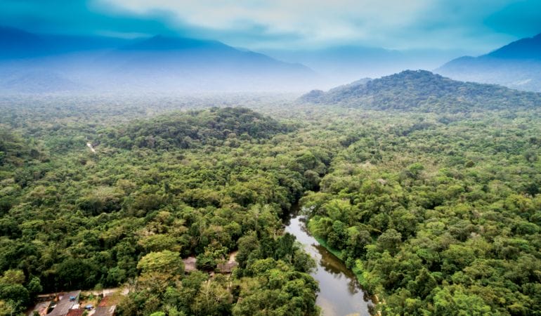
Lead image: Amazon rainforest, Brazil. Credit: Gustavo Frazao via iStock/Getty Images Plus.
Fa, Julia E., and James EM Watson, Ian Leiper, Peter Potapov, Tom D. Evans, Neil D. Burgess, Zsolt Molnár, Álvaro Fernández-Llamazares, Tom Duncan, Stephanie Wang, Beau J. Austin, Harry Jonas, Cathy J. Robinson, Pernilla Malmer, Kerstin K. Zander, Micha V. Jackson, Erle Ellis, Eduardo S. Brondizio, Stephen T. Garnett. 2020. “Importance of Indigenous Peoples’ Lands for the Conservation of Intact Forest Landscapes.” Frontiers in Ecology and the Environment 18(3): 135–140.