Planning for Social Equity
Over the past 40 years, economic inequality in the United States has returned to levels last seen in the 1920s, according to data from the National Bureau of Economic Research in Cambridge, Massachusetts (Saez and Zucman 2014). This gap has become more pronounced in many cities where wealth and poverty are concentrated geographically.
In 1970, 15 percent of families in the United States lived in neighborhoods where most residents were either very rich or very poor. By 2012, this stratification had more than doubled, with more than a third of families living in neighborhoods that were mostly affluent or mostly impoverished, according to researchers from Stanford and Cornell universites (Reardon and Bischoff 2016). Poverty was the top economic concern of 100 mayors in 41 states, according to the 2016 Menino Survey of Mayors. Abundant data show that many poor neighborhoods have disproportionately high minority populations and lack access to jobs, good schools, and other opportunities necessary to help residents rise out of poverty.
Last October, at the Big City Planning Directors Institute in Cambridge, Massachusetts—hosted by the Lincoln Institute of Land Policy, the Harvard Graduate School of Design, and the American Planning Association—the issue of equity arose repeatedly as planning directors discussed their recent efforts. In many cities, urban planners are examining old policies and writing new ones to achieve a fairer, more balanced distribution of public resources in the built environment. Planners are collaborating with city residents as well as colleagues in economic development, transportation, education, housing, social services, and parks and recreation to plan strategically for greater opportunity in areas of concentrated poverty. Their goal is to make these communities more inclusive, resilient, and sustainable by providing transportation options, safe street networks, affordable housing, and access to jobs, good schools, health care, healthy food, and green space.
Why is equity being addressed now, when many cities have been dealing for decades with service gaps between rich and poor neighborhoods? And how are cities approaching the challenge of planning to increase opportunity in disadvantaged areas?
“A growing body of research shows how regions that engage the entire community in economic opportunity are as a whole more successful,” says Amy Cotter, manager of urban development programs for the Lincoln Institute. She says planning for equity in land use and development is becoming a priority for many municipalities and regions—especially those that are uncertain about their economic future and looking to strengthen it. “The way in which we choose to use our land either helps or hinders people’s access to opportunity,” Cotter says.
The Obama Administration’s 2009 Sustainable Communities Initiative and new Fair Housing rules in 2015 also brought the conversation to the national level. These federal efforts affirmed that housing location plays a big role in opportunity and that “it has to be accessible and connected,” says Cotter.
The Healthy Cities movement has helped distressed communities create access to fresh food and safe walkable and bikeable routes to transit and schools.
And the planning profession itself has also been evolving in recent years from the “DAD” model (decide, announce, defend) to community engagement in collaborative planning from the ground up, notes Jessie Grogan, planning and urban form program manager for the Lincoln Institute. Planners “are doing innovative public engagement and asking questions differently,” often with support from new data and mapping tools, to collaborate with communities that may not have been acknowledged in the past, she says. Planners are also learning that what data suggests about neighborhood needs and assets can be quite different from what the neighborhood residents perceive about needs and assets.
This new orientation is translating into new policies and projects. Cash-strapped municipalities are likely to start with changes they can effect quickly and affordably to make assets more available, such as adding protected bike lanes or bus shelters in poor neighborhoods, or removing barriers that impede safety and walkability, says Cotter.
Some cities are approaching equity on a larger scale. Dallas and Baltimore share a legacy of segregation that was codified for generations along racial and economic lines, and continues to limit opportunities for growing poor and minority populations today. Recent tragic events thrust both cities into the forefront of a national dialogue about racial justice—the July 2016 shooting deaths of five police officers in Dallas and the April 2015 death of a black man, Freddie Gray, while in police custody. Behind the spotlight, both cities have focused for the past couple years on dispelling concentrated poverty by introducing connections and a better quality of life to disadvantaged neighborhoods.
Dallas
Disparities between rich and poor neighborhoods are greater in Dallas than in any other U.S. city, according to a 2015 Urban Institute analysis of U.S. Census data related to household income, educational attainment, homeownership rates, and median housing values (Pendall and Hedman 2015). With 1.3 million people in 340 square miles of land, Dallas is part of the nation’s fourth-largest metro area. The region is rich with growth and prosperity, but critical socioeconomic problems have dramatically impacted neighborhoods citywide. Dallas has the highest child poverty rate of the 10 biggest U.S. cities; the Mayor’s Task Force on Poverty found that the poverty rate rose by 42 percent in the previous 15 years (Clayton and Montoya 2016) and that, in some neighborhoods, 50 and even 70 percent of households were poor. Dallas has a low 3.7 percent unemployment rate but tremendous income disparity, declining middle-income households, blight in concentrated areas, and a mismatch between job locations and high-quality affordable housing, with high unemployment and poverty especially concentrated in southern Dallas neighborhoods.
These disparities may have been institutionalized: In 2014, the U.S. Department of Housing and Urban Development (HUD) issued a report accusing city officials of misusing federal housing funds in a manner that caused racial segregation between northern and southern Dallas. The city was also at the center of a 2015 U.S. Supreme Court ruling that declared that policies that led to segregating minorities into poor neighborhoods, even if unintentional, violated the 1968 Fair Housing Act.
Compared to other cities, Dallas may not appear more exclusionary. But because of its history of geographic segregation, disinvestment in poorer neighborhoods was more ingrained, says Peer Chacko, Dallas planning and urban design director. In the 1960s, desegregation of the Dallas public schools led to white flight to the suburbs, leaving concentrations of poor black families in the city. Interstate highway construction beginning in the 1960s led to further isolation and disinvestment. Interstate-30, for example, bisects Dallas into, broadly speaking, a more affluent and whiter northern hemisphere and a poorer and predominantly black and Latino southern hemisphere (half of the poor here are Latino). Spanning 185 square miles, southern Dallas is home to 45 percent of the city’s population but produces only 15 percent of its tax base. Many neighborhoods are characterized by deteriorating industrial sites, run-down buildings, crumbling streets and sidewalks, many bars and liquor stores, and empty weed-choked lots.
“Other cities have been planning for equity for a longer period of time, but now we’re dealing with it seriously,” says Chacko. “It’s a focused effort with clearly stated goals.” And it’s not easy: Any action the city takes is highly debated and polarizing, he says. “The conversation always starts with, ‘Should the government be involved in this? How will it affect our taxes?’” For many reasons, he adds, “equity has been easy to ignore.”
Equity, however, is “foundational” to the city’s success, says Teresa O’Donnell, Dallas’ chief resilience officer and former chief planning officer. The Dallas resilience office, funded by the Rockefeller Foundation’s 100 Resilient Cities initiative, is in its third of four years of grant funding with a goal of addressing long-term stressors of poverty, income inequality, and social issues. The resilience strategy focuses on four key areas: transportation equity, healthcare and access to medical services, decline and disinvestment in neighborhoods along racial lines, and economic resilience.
Dallas is the core city in the booming Dallas-Fort Worth metro region, says O’Donnell, but growth trends suggest that economic vitality could be drained from the urban core, as in Detroit. Dallas competes for workers with Fort Worth, Arlington, and many suburban centers. But because of social issues, low-wage jobs, lack of affordable housing within the city, and policies that prevented affordable housing in surrounding areas, Dallas has a greater concentration of poor neighborhoods and could find itself home to all the regional poor in the future. “We need to make sure that doesn’t happen,” O’Donnell says.
It’s also unfair that people in Dallas’ poorer neighborhoods don’t have access to better schools, housing, and services, says O’Donnell. “Transit equity is key to that.” She says that Dallas’ $10 billion light-rail system does not reach many of the disadvantaged neighborhoods, and other options, such as enhanced bus and alternative-mode transportation, are needed for underserved areas.
Growing South with Transit
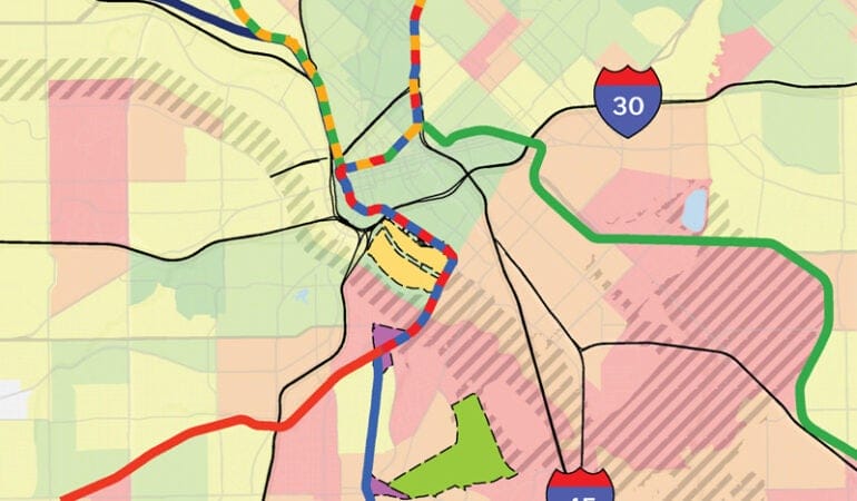
Over the past decade, the City and the Dallas Area Regional Transit (DART) agency have launched transit-oriented development (TOD) initiatives intended to bring jobs and investments to parts of the city that need a boost and have room to grow (see map p. 27). Dallas’ light-rail system includes 92 miles of track and 62 stations—19 of them in southern Dallas, with more under construction. Helped by private investments and public financing strategies such as tax increment financing (TIF) districts, some southern Dallas TOD areas have welcomed jobs and housing by mixing market-rate and affordable workforce housing with amenities and new public investments in infrastructure.
In 2008, the Office of Economic Development created the TOD Tax Increment Financing (TIF) District, spanning from north Dallas along the red and blue light-rail lines to southern Dallas’ VA Medical Center Station, an economic base with 3,000 jobs and millions of patient visits per year, located in the Lancaster Corridor seven miles south of downtown. The funding structure for the TOD TIF district, whose boundaries were extended in 2010, allows for an increment-sharing arrangement, in which some projected revenues are passed from higher-income station areas to lower-income areas to subsidize development. The TOD TIF budget—with a projected total of $415 million through 2038—is intended for development that attracts jobs and middle-income residents, including public infrastructure, environmental remediation, and parks and open space. Affordable housing is required (at least 20 percent per housing project), and high-quality design that blends market-rate and affordable housing is encouraged.
The city’s GrowSouth initiative, launched in 2012 by Mayor Michael Rawlins to jumpstart investment with infrastructure and capital improvements, has brought attention to southern Dallas, which Rawlins has called “the greatest single opportunity for growth in North Texas.” GrowSouth’s 2016 report notes that southern Dallas’ tax base increased nearly $1.6 billion from 2011 to 2015 (City of Dallas 2016). This includes revenues from redevelopment projects where adaptive reuse of historic buildings and new mixed-use development—with housing, offices, hotels, restaurants, and infrastructure such as sidewalks, street trees, and lighting around transit stations—have helped attract thousands of millennials and others to live and work in neighborhoods closer to downtown, such as Cedars and North Oak Cliff.
The Lancaster corridor is a priority area for both TOD TIF funding and the GrowSouth initiative. Across from the VA Medical Center and light-rail station, the $30 million 192-unit Lancaster Urban Village mixed-use apartment complex, opened and fully leased since 2014, is considered a model for development accomplished with TOD TIF and other public monies. The 3.5-acre site includes a resort-style pool, fitness and business centers, a parking garage, and 14,000 square feet of ground-level retail and restaurant space. Half the units are affordable and half are market-rate. The historically African-American neighborhood, now half-Latino with many seniors and immigrants, is fairly stable, though it has high poverty and unemployment rates and many dilapidated buildings. In partnership with the city, the developers—Dallas-based Catalyst Urban Development and City Wide Community Development Corporation—saw potential, especially in the site’s location next to transit, the VA hospital, and the adjacent offices of the Urban League of Greater Dallas.
The mixed-use housing project demonstrates how the TOD TIF, land acquisition, infrastructure development, and other public subsidies have helped inject greater economic and social wealth into the neighborhood, says Chacko. “The particular success of the market-rate component shows that.”
Neighborhood Plus Plan
Since 2015, a comprehensive new planning and urban design department that is more directly engaged in economic development, street planning, housing, and other key issues has addressed Dallas’ revitalization efforts in areas of concentrated poverty through the Neighborhood Plus plan. Adopted in October 2015 with the endorsement of Mayor Rawlins and all 14 city council members, Neighborhood Plus reflects a new, more holistic “neighborhood by neighborhood” approach to improving quality of life for all Dallas residents, says Chacko. To draft the plan, the city partnered with many groups, including the U.S. Department of Housing and Urban Development (HUD) and the Inclusive Communities Project, the Dallas-based advocacy organization behind the Supreme Court case. The plan was intended to help respond to HUD’s accusations of noncompliance with civil rights statutes.
Neighborhood Plus’s key goals are to create a collective impact framework, alleviate poverty, fight blight, attract and retain the middle class, expand homeownership, and enhance rental housing options. Chacko says the city is making progress on all these goals. The planning department’s Neighborhood Vitality division formed a core group from various city departments, including economic development, the police, the city attorney’s office, and the code department. They developed an impact framework with 11 target areas throughout the city, half of them in southern Dallas, and they’re developing interdepartmental teams and action plans for each target area with partners from the Dallas Independent School District, the business community, and nonprofit organizations.
The planning department is also working on the city’s first inclusionary zoning strategy for affordable housing. With help from Southern Methodist University, planners are creating a strategic action plan for fighting blight, based on a report completed for the city by the Center for Community Progress, a national nonprofit dedicated to rebuilding vacant and abandoned properties. In southern Dallas, the city has created a tax rebate program to encourage property owners to invest in renovating homes to make distressed properties livable and code-compliant. In one target area, the city is also talking with Habitat for Humanity about building homes.
“The emphasis now is on a much greater degree of public involvement in improving quality of life,” says Chacko. The city is trying to create priorities for infrastructure and funding for target areas. Chacko says the target areas have helped create a much broader consensus among city council members that equity “is a critical issue, and that we should make a concerted effort to align planning with investment decisions,” including potential bond program requests that might be voted on in 2017. This is a shift for Dallas, where planning generally has focused on land use and development rather than strategic investments, says Chacko. Neighborhood Plus “shines a spotlight on equity and makes it clear that we can’t ignore this issue. It is important for the long-term health of Dallas.”
Baltimore
Baltimore, which ranked number three on the Urban Institute’s list of inequitable cities (Pendall and Hedman 2015), has distinct “health and wealth gaps” between more affluent white neighborhoods and poorer black neighborhoods. The majority of Baltimore’s high-poverty, low-opportunity neighborhoods are concentrated just east and west of downtown. This pattern traces back to redlining maps from the 1930s, when Baltimore spawned “a huge legacy of proactive disinvestment along racial lines, where city ordinances drew lines so black families couldn’t move across the street,” says planning director Thomas Stosur. These areas concentrated predominantly with poor black residents are a result of restrictive covenants, urban renewal, the Federal Housing Administration’s system for mortgage loan approval, and other policies that “directly contributed to many of the economic and social challenges Baltimore City faces today,” notes the Baltimore City Department of Planning’s 2015 Equity Action Plan.
With a population of 622,000 within 81 square miles, Baltimore is also booming, with 15,000 mostly higher-end housing units built since 2010 and large mixed-use redevelopment projects under construction in the Baltimore Harbor area. The city’s population is 63 percent black, and its predominantly black neighborhoods have higher unemployment rates, more children living in poverty, less access to goods and services, and lower educational attainment than the city’s predominantly white neighborhoods. The Baltimore Neighborhood Indicator Alliance found a 22.4-year difference in life expectancy according to race and location within the city: a neighborhood with 96 percent black residents had the lowest life expectancy, and a neighborhood with only 20 percent black residents had the highest.
Undoing the city’s legacy of segregation and inequity is now a big focus for the planning department. In March 2015, they held staff training on structural racism, often defined as the normalized and legitimized range of policies, practices, and attitudes that produce cumulative and chronic adverse outcomes for people of color. One month later, Freddie Gray was killed, and the riots that ensued in Baltimore’s isolated poor neighborhoods “underscored a need to refocus on equitable development,” says Stosur. In June 2015, the city announced the One Baltimore initiative, a public-private effort to support opportunities for children, families, and neighborhoods. Department staff created the Equity in Planning Committee and an internal action plan that calls for the use of an “equity lens.”
Inspired by the Urban Sustainability Directors Network, the equity lens requires the commitee to apply certain questions when considering potential policy changes and planning projects: What historic advantages or disadvantages do residents face? Are there policy barriers that can be removed to close health and wealth gaps? Are engagement and representation inclusive, accessible, and authentic? What policies are available to prevent displacement as neighborhoods change and to preserve opportunities for existing and low-income residents?
The planning department is starting to use the equity lens for all programs and projects. For example, the city’s recently released Food Environment Map, which addresses food access across Baltimore neighborhoods, examines ways that policies and programs impact low-income residents and people of color. The explicit focus of the lens is racial equity, but planners are applying it more broadly for women, youth, the elderly, recently arrived immigrants, and residents who are LGBT, low-income, homeless, or who have disabilities or limited English proficiency.
Sustainability Plan through an Equity Lens
At the same time the planning department formed the equity committee, it began using an equity lens to update its 2009 Sustainability Plan “to hear more voices, and from people who aren’t usually heard from,” says Anne Draddy, sustainability coordinator for the city. The plan update is being overseen by the Commission on Sustainability and a sustainability committee, including commissioners and community members. It will use an equity lens to focus on environmental issues such as sustainable land use, biodiversity, energy efficiency, resiliency, and the overall economic climate of the city. The effort “will focus on our most vulnerable, historically disinvested neighborhoods” to help improve conditions “where the most severe racial inequities exist,” notes the sustainability office website.
The city’s outreach focuses on a new community engagement process. The sustainability office recruited 125 resident ambassadors at community meetings and through its website to ask Baltimoreans what they want to see changed in their neighborhoods. About 68 percent of ambassadors are African-American, reflecting planners’ efforts to mirror the racial demographics of the city. The planning department also hired an equity consultant to train staff and the ambassadors and developed a brief neighborhood survey. “As we went through training with the ambassadors,” says Draddy, “we turned the [predetermined] survey questions around to: What are the three things you like best about your neighborhood and the three things you like least? We took a chance and stepped out of our comfort zone.”
Planners divided the city into 10 random districts, depending on population, and designated a lead in each district. With grant funding from the Town Creek Foundation in Maryland and the Urban Sustainability Directors Network, they paid each lead $400 to create a team and gave team leaders an iPad and a $300 gift card to buy t-shirts, hats, or a meal for their teams. Planners also assembled a tool kit and binders and provided water bottles and thousands of pens for residents who attended meetings (the swag was very important to youth ambassadors and residents involved in this new kind of community outreach, notes Draddy). Planners and ambassadors also worked with 25 groups, including those involved in transportation, energy, urban design, and racial justice. They documented the race, age, sex, and neighborhood of people who attended meetings and responded to the survey online.
“The equity consultant urged us to go for metrics to understand and link responses,” says Draddy. “That was an important element.” She says the community has expressed appreciation for “being listened to.” A draft survey report is due in early 2017.
INSPIRE Community and Schools Program
Partnering with the Baltimore City Public Schools, Maryland Stadium Authority, and the State of Maryland, Baltimore is investing $1 billion in the 21st Century Schools Initiative to renovate or replace 24 city schools over the next several years. The planning department is leading a $5 million initiative called INSPIRE (Investing in Neighborhoods and Schools to Promote Improvement, Revitalization, and Excellence) in neighborhoods within a one-quarter-mile radius around each school. Planners are conducting workshops and focus groups and working with neighborhood teams to develop individual vision plans outlining public and privately funded improvements to public infrastructure, transportation, housing, and open space around each INSPIRE school.
“We’re attempting to take the catalyst of new $30- or 40-million school buildings to bring stakeholders together to build an improvement strategy,” says Stosur. “This is huge, and we hope a game changer to market these neighborhoods to populations that might not be aware of the housing stock nearby. We want to engage residents around this school topic.” INSPIRE teams are looking to improve students’ routes to school with new sidewalks, lighting, green spaces, playgrounds, community gardens, and public art.
These efforts piggyback on another initiative by former Mayor Stephanie Rawlings-Blake to attract 10,000 families to inner-city neighborhoods. Rawlings-Blake also proposed a plan to spend more than $135 million to build or upgrade 40 recreation centers across the city, funded in part by leveraging the sale proceeds of four downtown parking garages. The plan would expand and upgrade small outdated recreation centers in underserved areas with swimming pools, gyms, and other facilities that more affluent neighborhoods have had access to, and would capitalize on investments made through Inspire. The new Baltimore mayor, Catherine E. Pugh, who took office in December 2016, along with a city council of 15 that includes eight new council members, will determine how these and other initiatives go forward.
Green Network Plan
The Baltimore planning department is the project manager for the Green Network Plan, launched in April 2016 to repurpose some of the city’s 30,000 vacant and abandoned properties into new green infrastructure such as parks, community gardens, urban farms, open space, and stormwater management areas. The plan is intended to remove blight, stabilize neighborhoods, and fill in gaps in the city’s existing green network. A consultant team led by Baltimore-based Biohabitats is assisting in the plan development process, using real estate data, computer mapping, and environmental planning techniques. Collaborating with the Parks and Recreation department, planners will assess opportunities to connect new green spaces to parks, trails, open space, and forests developed from a 1904 plan created by the Olmsted Brothers landscape architects. Planners will also analyze vacant parcels to identify those that could be assembled for future residential and mixed-use redevelopment.
The plan is “attempting to directly address equity in high-poverty, high-challenge neighborhoods,” especially in East and West Baltimore, which have the least green infrastructure, says Stosur. “It’s time to look at how to change the paradigm in these neighborhoods. We all know the blight has to go, and we want to do it in a responsible, well-planned way.”
Four sites in East and West Baltimore have been identified for community charrettes for pilot greening projects. Like INSPIRE, the green network plan will be underwritten by capitalizing on other public funding streams. The State of Maryland is paying for demolition and stabilization projects throughout the city via Project C.O.R.E. (Creating Opportunities for Renewal and Enterprise). This funding, together with the city’s Vacants to Value targeted code enforcement and redevelopment program, as well as the city’s “MS4” Stormwater Permit funded through the water-ratepayer utility—potentially will invest tens of millions of dollars in federal, state, and local funds to develop the green network plan, says Stosur. A green network vision plan is due in 2017.
Planners in Dallas, Baltimore, and other cities acknowledge that planning-for-equity measures alone won’t solve the deep-rooted problems that accompany poverty and racial discrimination in disadvantaged neighborhoods. But they say that collaboration with these communities, as well as carefully targeted investments, can begin to provide opportunity where little existed before.
Kathleen McCormick, principal of Fountainhead Communications, LLC, lives and works in Boulder, Colorado, and writes frequently about sustainable, healthy, and resilient communities.
References
Baltimore Green Network Plan. 2016. www.baltimoresustainability.org/projects/green-network/
City of Dallas. 2016. GrowSouth. www.dallasgrowsouth.com/year5presentation
City of Dallas. 2015. Neighborhood Revitalization Plan for Dallas. June. www.dallascityhall.com/departments/pnv/DCH%20Documents/Neighborhood-Plus-June17-small.pdf
Clayton, Mark and Regina Montoya. 2016. “Reducing the Epidemic of Poverty and Ending the Opportunity Gap.” Mayor’s Task Force on Poverty Briefing to the Dallas City Council. September 7. http://dallascityhall.com/government/Council%20Meeting%20Documents/b_reducing-the-epidemic-of-poverty-and-ending-the-opportunity-gap_combined_090716.pdf
Pendall, Rolf with Carl Hedman. 2015. Worlds Apart: Inequality between America’s Most and Least Affluent Neighborhoods. Washington, D.C.: Urban Institute. www.urban.org/sites/default/files/alfresco/publication-pdfs/2000288-Worlds-Apart-Inequality-between-Americas-Most-and-Least-Affluent-Neighborhoods.pdf
PolicyLink Equitable Development Toolkit. 2014. www.policylink.org/equity-tools/equitable-development-toolkit/