Moderator: Heather Hannon
Speakers: Andreea D. Udrea, Lucy Kempf, and Meagan McMahan
SHARE
This session will be presented by the Lincoln Institute of Land Policy at the American Planning Association’s National Planning Conference.
Increasingly, states are taking legislative action to preempt planning and zoning decisions by local governments. Sometimes this can pave the way for important planning initiatives, but it can also prevent cities from achieving their goals. Hear from a national land use law expert and planning directors from across the country about how state preemption is affecting local planning—for better and for worse.
Detalles
Fecha(s)
Mayo 28, 2026
Hora
3:30 p.m. - 4:30 p.m. (EDT, UTC-4)
Ubicación
Online, Channel 1
Idioma
inglés
Palabras clave
vivienda, planificación
Eventos
NPC 2026 Session: Exploratory Scenario Planning for Brazil’s Public Lands
This session will be presented by the Lincoln Institute of Land Policy at the American Planning Association’s National Planning Conference.
Brazil’s Secretariat for Federal Assets (SPU), an agency within the Ministry of Management and Innovation in Public Services (MIG), collaborated with the Lincoln Institute of Land Policy to apply exploratory scenario planning (XSP) to federal land policy. The work supports the Imóvel da Gente (Property of the People) program, which positions federal land as a strategic asset for socio-environmental development.
Attendees will learn how futures thinking can be integrated into national policy frameworks with practical methods for designing participatory scenario planning processes in complex governance settings. The session will present strategies for engaging multiple agencies, fostering collaboration among jurisdictions, and embedding equity goals into long-term planning.
Through the case of Brazil’s first XSP initiative, participants will explore tools for identifying drivers of change, developing plausible future scenarios, and translating scenario outcomes into actionable strategies. These approaches can help planners address uncertainty, adapt to shifting conditions, and create policies that are both resilient and inclusive.
The session emphasizes how collaborative, futures-oriented methods can strengthen institutional capacity, broaden participation, and ensure that land use policies serve diverse community needs. Attendees will leave with transferable strategies to support equitable, future-ready planning in their contexts.
Detalles
Fecha(s)
Mayo 28, 2026
Hora
2:30 p.m. - 3:15 p.m. (EDT, UTC-4)
Ubicación
Online, Channel 1
Idioma
inglés
Palabras clave
planificación, planificación de escenarios
Eventos
NPC 2026 Session: Navigating Uncertainty—Using Strategic Foresight for Action-Oriented Planning
Moderator: Heather Hannon
Speakers: Elizabeth Ginsberg, and Austen Edwards
SHARE
This session will be presented by the Lincoln Institute of Land Policy at the American Planning Association’s National Planning Conference.
Planners are fielding more “what-if” questions than ever as residents and local officials cope with increasing uncertainty and rapid change. Scenario planning is a systematic approach to answering these questions and kickstarting conversations with stakeholders about possible futures and their implications for today’s better decisions. These foresight tools can help planners create more flexible, resilient strategies to achieve local goals, come what may.
This presentation highlights how the Chicago Metropolitan Agency for Planning (CMAP) is using horizon scanning and exploratory scenario planning to define a long-term vision (the Century Plan) in a large, complex metropolitan region composed of seven counties, 284 municipalities, and 8.5 million residents. CMAP is considering drivers of change and an understanding of regional systems—including transportation, natural resources, and the economy—to explore the grand challenges and strategic responses that should define the region’s next era. Presenters explore how these tools are bringing foresight into planning and discussions for bold regional action. Learn how CMAP engaged with elected leaders and other planners, and how you can use resources from state and regional agencies to encourage local officials to shift to a horizon-based mindset.
Detalles
Fecha(s)
Mayo 28, 2026
Hora
1:30 p.m. - 2:15 p.m. (EDT, UTC-4)
Ubicación
Online, Channel 2
Idioma
inglés
Palabras clave
planificación, planificación de escenarios
Eventos
NPC 2026 Session: Equitable Urban Planning for a Changing Climate
Moderator: Amy Cotter
Speakers: Eleanor Sharpe, Emilia Oscilowicz, and Adam Lyons
SHARE
This session will be presented by the Lincoln Institute of Land Policy at the American Planning Association’s National Planning Conference.
This presentation offers actionable strategies to help planners advance equitable policies that simultaneously address climate change, housing affordability, and economic inequality. A new Lincoln Institute Policy Focus Report, Planning in a Polycrisis, synthesizes responses from surveys of professional planners and policymakers working in cities across North America. It highlights emerging innovations and the trade-offs in effectively integrating these considerations into their work. Other constraints are due to shifting political landscapes, limited funding, and deepening social vulnerabilities. However, these planners’ work also advances integrated, equity-driven urban climate planning, and their innovations form a framework for cities to move from ad hoc responses toward a long-term equitable climate urbanism.
The report’s authors and practicing planners explore practical strategies to address the barriers and trade-offs cities face. The conversation sheds light on how climate and housing planning can co-adapt to counter rising socioeconomic vulnerability, with a focus on the most recent shifts in practice. Showcasing these examples aims to empower city leaders with specific recommendations and strategies for advancing a model of climate urbanism that responds to the demands of polycrisis.
Moderator: Mary Ann Dickinson
Speakers: Kyle Mucha, Manny Patole, and Brett Gracely
SHARE
This session will be presented by the Lincoln Institute of Land Policy at the American Planning Association’s National Planning Conference.
As the demand for digital infrastructure and artificial intelligence accelerates, communities are increasingly approached by data center operators seeking suitable sites. While marketed as drivers of economic growth, these facilities often carry significant costs that are not fully transparent during the siting process. Data centers require immense physical resources—land for large footprints, vast amounts of water for cooling, and energy that strains local grids—raising questions about sustainability and long-term resilience. They also may introduce frontline communities to new sources of pollution, increased truck traffic, and environmental justice concerns, yet these voices are often marginalized in opaque political and regulatory processes. Promised economic benefits, such as job creation and tax revenue, are frequently overstated or unevenly distributed, leaving cities to shoulder environmental burdens with limited community gain.
This presentation convenes a diverse panel to unpack complex planning challenges such as critically assessing data center proposals, advocating for accountability, and elevating community priorities. By examining the trade-offs of siting decisions through the lenses of resource management, equity, and governance, you will leave with practical strategies to question assumptions, navigate political opacity, and build stronger negotiating positions to ensure decisions genuinely serve the long-term interests of municipalities and their residents.
Moderator: Ievgeniia Dulko
Speakers: Petra Hurtado, Senna Catenacci, and Alykhan Mohamed
SHARE
This session will be presented by the Lincoln Institute of Land Policy at the American Planning Association’s National Planning Conference.
Futures literacy is becoming increasingly important in planning. It is the skill that allows people to better understand the role the future plays in what they see and do. This involves imagining multiple plausible futures, incorporating future scenarios into our work, and planning with foresight.
This interactive learning experience, presented in a learning lab format, focuses on applying strategic foresight in planning and serves as an essential learning lab for individuals dedicated to shaping a better future for their community.
Moderator: Ievgeniia Dulko
Speakers: Petra Hurtado, Senna Catenacci, and Joseph DeAngelis
SHARE
This session will be presented by American Planning Association at the American Planning Association’s National Planning Conference.
We live in a world characterized by accelerating change and increased uncertainty. Planners are tasked with helping their communities navigate these changes and provide guidance on preparing for an uncertain future. However, conventional planning practices often fail to adequately consider the future, even while planning for it. Most plans reflect past data and current assumptions but do not account for emerging trends on the horizon.
To create resilient and equitable plans for the future, planners need to incorporate foresight into their work. This presentation outlines emerging trends that will be vital for planners to consider and introduces strategies for making sense of the future while practicing foresight in community planning. By embracing foresight, planners can effectively guide change, foster more sustainable and equitable outcomes, and position themselves as critical contributors to thriving communities. The practice of foresight is imperative for equipping communities for what lies ahead.
The Lincoln Institute of Land Policy today released the Policy Focus Report Planning in a Polycrisis: Equitable Urban Strategies for a Changing Climate. Across the United States and Canada, city planners face a “polycrisis,” as the interacting challenges of adapting to climate change, ensuring housing affordability and security, and prioritizing economic inclusion put competing demands on localities’ limited resources, attention, time, and capacity. This report, written by Emilia Oscilowicz, James J. T. Connolly, and Isabelle Anguelovski from the Barcelona Lab for Urban Environmental Justice and Sustainability and with affiliations at the Universitat Autònoma de Barcelona and the University of British Columbia, offers a path forward by producing a framework of actionable strategies for practitioners, policymakers, and others.
“Local leaders face increasing pressure created by converging crises. This report aims to alleviate that pressure by providing a more equitable policy framework,” said George W. McCarthy, president and CEO of the Lincoln Institute. “Creating more climate-friendly, affordable homes while simultaneously cultivating agency, participation, and engagement from frontline communities creates more sustainable urbanism that leads to better outcomes across the board.”
In 2025, researchers interviewed 32 planners and practitioners across five cities—Boston, Massachusetts; Denver, Colorado; Portland, Oregon; Vancouver, British Columbia; and Washington, DC—and mobilized prior interviews they conducted in those cities to find that traditional approaches to climate action, housing, and economic development are often siloed, which spreads municipal resources very thin. After thorough analysis, the authors created an overarching framework that empowers city leaders to advance climate urbanism that addresses these interconnected challenges.
The recommendations include securing and expanding local climate action funding; championing resilient, affordable housing solutions; strengthening local economies and connection to place through climate resilience; restructuring and coordinating municipal planning; leveraging short-term projects for long-term goals; and fostering respectful, ongoing community engagement.
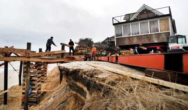
Lead Image: Homeowners in Truro, Massachusetts, were able to move their house onto stilts to mitigate the encroaching threat of beach erosion. Credit: John Tlumacki/The Boston Globe via iStock/Getty Images Plus.
Visita con un becario
Decodificar la corrupción en el desarrollo económico urbano
El Instituto Lincoln ofrece diversas oportunidades para investigadores que se encuentran a inicios o mitad de sus carreras. En esta serie, hacemos un seguimiento de nuestros becarios para conocer más sobre su trabajo.
Hace varios años, se dio a conocer una importante operación encubierta del FBI en Tallahassee, Florida. Los agentes federales se habían infiltrado en el gobierno de la ciudad, haciéndose pasar por promotores inmobiliarios, y sobornaron con éxito a los funcionarios de desarrollo económico local para ganar votos y contratos.
Kerry Fang, que enseñaba en la Universidad Estatal de Florida en Tallahassee en ese momento, observó cómo se producían múltiples arrestos y se dictaban condenas. Y en la valiosa colección de correspondencia por correo electrónico, registros de reuniones y otras pruebas presentadas que se hicieron públicas, Fang, ahora profesora adjunta de Planeamiento Urbano en la Universidad de Illinois en Urbana-Champaign, vio una valiosa oportunidad de investigación.
“Pude obtener todo ese material, que es especialmente rico y difícil de encontrar, y analizar la existencia de patrones específicos de comunicación en proyectos de corrupción. ¿Podemos ver algunas pistas de corrupción en los intercambios de correos electrónicos?”, comenta Fang. “Ahora estoy trabajando en un libro que analiza la corrupción en los proyectos de desarrollo económico en su conjunto, porque, desafortunadamente, en realidad es más común de lo que pensamos”.
¿El título del libro? “El título provisional es The Most F—d Up Place: An Anatomy of Corruption in Urban Economic Development (El lugar más j—dido: anatomía de la corrupción en el desarrollo económico urbano)”, agrega Fang. La blasfemia proviene de la colorida descripción de la causa de Tallahassee por parte de un agente del FBI.
Fang comenta que sus estudiantes en ese entonces estaban consternados, desalentados y motivados por el escándalo de corrupción. “Estoy muy orgullosa de algunos de mis antiguos estudiantes en el estado de Florida, porque me escucharon hablar de esto en clase y se enojaron”, agrega. “Una de mis exalumnas se postuló para la oficina del comisionado de la ciudad en Tallahassee, y ahora se enorgullece de ser parte de la oficina del comisionado de la ciudad”.
En 2020, Fang recibió una beca internacional del programa de China del Instituto Lincoln de Políticas de Suelo para estudiar los impactos de la tenencia del suelo en la salud de los niños en la China rural. La investigación de su documento de trabajo resultante se publicó el año pasado en la revista revisada por pares Feminist Economics.
En esta conversación, que se editó por motivos de longitud y claridad, Fang comparte más información de su investigación, por qué los planificadores deben aprender a navegar la política local y por qué considera que la acción y la investigación son antídotos contra la desesperanza.
JON GOREY: ¿Cuál es el enfoque general de la investigación? ¿Y cómo cree que la beca del Instituto Lincoln contribuyó en ese trabajo?
KERRY FANG: El enfoque principal de mi investigación es la política de uso de suelo y su impacto en la equidad y la sostenibilidad, así como la política de desarrollo económico. Ambos campos son pilares muy, muy importantes del urbanismo, y también tienen una conexión estrecha entre sí.
La beca Lincoln me ayudó muchísimo. Al criarme en China [donde, antes de 2003, los derechos colectivos de uso del suelo en las aldeas rurales solían asignarse por tamaño de hogar y redistribuirse de forma periódica], la pregunta particular que me interesaba era: ¿la prohibición de la redistribución de los derechos de uso del suelo, que tenía como objetivo poner fin a la inestabilidad de los hogares rurales, tiene consecuencias no deseadas al negar los derechos al uso del suelo a las mujeres y los niños que llegaron a una aldea después de la prohibición? ¿Esta situación afectaría su posición dentro de la familia, y afecta la forma en que la familia distribuye los recursos?
Gran parte de la investigación previa se centró en la familia en su conjunto, con la siguiente premisa: si la familia se beneficia, todos se benefician. Todos sabemos que no es eso lo que sucede ¿Quién es el jefe de la familia, quién está en verdad a cargo de los recursos de la familia? En especial en el contexto de la China rural, el hombre de la casa es el que tendrá los recursos, y ahora también puede ser el único que puede gozar de los derechos sobre el uso del suelo. ¿Y qué significa eso?
Me fascinó la pregunta y, con la beca Lincoln, pude hacer la encuesta y preguntar explícitamente quién tiene derechos sobre el suelo dentro de un hogar, y analizar cómo eso afecta la distribución de recursos y la salud de los niños, que se está convirtiendo en un problema en China. Descubrí que, cuando se les niega a los niños los derechos sobre el suelo, su salud se deteriora y es más probable que sean obesos. Si la esposa, es decir la madre, tiene derechos sobre el suelo, es más probable que la familia tenga una mejor cobertura de salud. Y si una niña tiene derechos sobre el suelo, es más probable que el padre pase tiempo con su hija.
JG:¿En qué está trabajando ahora o en qué le gustaría trabajar a futuro?
KF: Respecto del uso del suelo, siempre analicé la transferencia de los derechos de desarrollo. [Mientras estaba en la Universidad Estatal de Florida], comencé a colaborar con otros académicos que están muy interesados en la adaptación costera, y comencé a considerar el uso de la transferencia de los derechos de desarrollo como una herramienta para facilitar la adaptación costera. Porque, en teoría, es la herramienta que puede transferir los derechos de desarrollo de las áreas de alto riesgo a las áreas de menor riesgo. Entonces, tiene sentido, pero las aplicaciones prácticas son muy escasas.
Solo hay un puñado de programas con aplicaciones en los Estados Unidos. Hasta ahora, hubo estudios teóricos o estudios de caso individuales que no rastrearon en forma sistemática el desempeño o los diversos desafíos a los que se enfrentaron. Es por eso que comencé este trabajo, para en verdad analizar estas aplicaciones existentes del uso de la transferencia de los derechos de desarrollo para la adaptación costera y realizar un seguimiento sistemático de su desempeño.
En el otro frente del desarrollo económico, analicé cómo los planificadores se comunican con los políticos y si la comunicación modelará las decisiones de estos últimos. También estoy colaborando con algunos científicos informáticos para hacer un poco de minería de texto en los intercambios de correo electrónico de la causa Tallahassee, para tratar de ver si podemos encontrar pistas de corrupción en este material. ¿Es posible detectar la corrupción a partir de estos intercambios?
Durante muchos años, estudié economía desde una perspectiva más racional. Somos planificadores racionales que tratan de descubrir lo que es mejor para la ciudad, hacemos análisis de costo-beneficio para proyectos públicos a fin de determinar qué es lo correcto para la ciudad. ¿Pero es eso lo que está pasando en realidad? Muchas de estas cuestiones tienen una fuerte influencia de la política, las dinámicas de poder y, a veces, la corrupción rotunda. Es probable que encuentre casos de corrupción en casi todas las grandes ciudades de Estados Unidos si busca “corrupción en el desarrollo del suelo” o en el desarrollo económico.
Y los grandes proyectos que requieren tanto subsidio público se terminan aprobando de todos modos, a pesar de la abrumadora evidencia empírica que indica que los megaproyectos, en su mayoría, no dan frutos. Se aprueban de cualquier forma. Mi libro analizará ese tema de manera explícita, mostrando lo que está sucediendo, la dinámica de poder y el desequilibrio de poder que se infiltra en los proyectos de desarrollo económico urbano, y presentando algunas de las señales que debemos buscar, para verlo suceder en cada etapa del desarrollo, y señales de advertencia para que podamos ser capaces de detectarlo.
JG:¿Hay algo que la haya sorprendido o resultado inesperado durante toda su investigación?
KF: La parte de la corrupción sin duda me sorprendió. Es decir, no soy ingenua, sé que hay corrupción. No me había dado cuenta de lo arraigada que está en nuestras vidas y lo extendida que está, porque no hablamos de ello tan a menudo, en especial en los Estados Unidos. En la literatura, se trata como un problema de los países en vías de desarrollo.
Una gran parte sucede exactamente en mi ámbito de estudio, en el desarrollo del suelo y el desarrollo económico, porque ahí es donde está el dinero, ahí es donde está el poder. Y es más probable que nosotros, capacitados como planificadores, funcionemos como técnicos en estos organismos gubernamentales. Tenemos experiencia técnica, pero en realidad no somos muy buenos para navegar el panorama político.
JG:¿Qué le gustaría que más gente entendiera sobre el urbanismo, el uso del suelo o el desarrollo económico?
KF: Que están conectados, y eso es realmente importante. Siento que estamos un poco sobreespecializados en distintas cuestiones y que nos aislamos en diferentes categorías.
Una gran parte de lo que hago es tratar de generar conexiones. Por lo tanto, mi trabajo en uso de suelo y planificación medioambiental intenta establecer una conexión entre el uso del suelo para promover la planificación medioambiental y la adaptación costera, lo que también apoya el desarrollo económico, la sostenibilidad social y la equidad en general. Y mi trabajo en corrupción y desarrollo económico en verdad está conectando el desarrollo económico y el desarrollo del suelo con la política urbana y la gobernanza urbana.
No se puede mirar desde una única perspectiva sin tener en cuenta a las demás. El sistema urbano es un sistema integral.
JG:Me intrigó una de las clases que imparte, Informática Urbana. ¿Puede contarme sobre este término y algo del periodismo de datos que han hecho sus estudiantes?
KF: Esta es una clase de pregrado que solo impartí una vez hasta ahora, pero estamos tratando de que nuestros estudiantes puedan usar los datos de manera efectiva para resolver problemas de urbanismo. La clase consta de tres módulos. El primero incluye métodos estadísticos, así como mapeo y análisis espacial, que son muy importantes para la planificación. El segundo módulo se centra en visualización de datos y periodismo de datos, porque la comunicación efectiva [es muy importante]; como planificadores, no solo tenemos que ser capaces de usar los datos, sino que tenemos que pensar en cómo comunicar los datos a nuestra audiencia y a diferentes tipos de audiencias. Es decir, tenemos que visualizar los datos de manera efectiva, mapearlos y contar una historia con los datos.
Y en el último módulo, llevo a mis estudiantes a la vanguardia de los métodos de aprendizaje automático, como la extracción de datos web (web scraping), el análisis de punto de interés (POI, por sus siglas en inglés), la minería de textos y los gráficos interactivos. Todas las novedades a las que, como urbanista, estará cada vez más expuesto: nuevos datos, nuevos métodos, datos en tiempo real que serán muy importantes en la gestión de las ciudades.
La clase del año pasado analizó diferentes barrios en Chicago con el objetivo de observar las diferentes características demográficas y económicas. Y como todos sabemos, no es que sea particularmente impactante, pero sigue siendo muy sorprendente ver a los estudiantes extraer los datos y visualizarlos, para exponer con claridad cuánta disparidad espacial hay en Chicago. Integraron muchas buenas técnicas de visualización que aprendieron en clase para hacer mapas muy efectivos. Y pudieron contar una muy buena historia sobre las fuerzas impulsoras de todos estos fenómenos y las marcadas diferencias que vemos: cuáles son algunas de las políticas y fuerzas sociales detrás y qué pueden hacer los planificadores para analizar esos problemas.
JG: En lo que respecta a su trabajo, ¿qué la mantiene despierta por la noche? ¿Y qué le da esperanza?
KF: Tanto la cuestión del poder político como la del clima. Ambas son las crisis de nuestro tiempo y, en días oscuros, siento que no tenemos esperanza en ambos frentes. El poder político es tan poderoso que a veces pienso en cómo puedo contrarrestarlo. La cuestión climática es un problema enorme que necesita mucha colaboración global, pero cada uno se cuida a sí mismo. Eso es lo que me mantiene despierta por la noche.
Para mí, lo que resulta empoderante es poder hacer algo. Creo que eso es parte de por qué estudio la política de uso de suelo para contribuir a facilitar la adaptación costera a los problemas climáticos y la dinámica de poder y el proceso político en el desarrollo económico urbano. Ambas son formas de mantener la cordura y hacerme sentir que estoy haciendo algo. También hago publicaciones al respecto todo el tiempo para, en primer lugar, concientizar sobre estos temas. Incluso si yo, como individuo, no puedo cambiar las cosas, si más personas se enteran, tal vez pueda llevarlas a la acción, como las de mis estudiantes. Es algo que me enorgullece.
En especial, en lo que respecta a la adaptación costera, sentí que mi trabajo podía generar implicaciones concretas y prácticas que pueden incorporarse directamente en la práctica. Como estoy en conversaciones con los planificadores a cargo de estos programas de transferencia de los derechos de desarrollo, en verdad puedo ayudarlos a ejecutar mejor sus programas. Y, si ese es el caso, puedo ayudar a algunas de estas comunidades a enfrentar el problema del cambio climático un poco mejor, y eso me hace sentir empoderada y con más esperanza para el futuro.
Jon Goreyes redactor del Instituto Lincoln de Políticas de Suelo.
Imagen principal: Kerry Fang, profesora adjunta de Planificación Urbana y Regional en la Universidad de Illinois Urbana-Champaign. Crédito: Foto de cortesía.
Drenaje de datos: los impactos en el suelo y el agua del auge de la IA
Un zumbido débil emerge desde lo profundo de una vasta tumba con luz tenue, cuyo ocupante devora energía y agua con un apetito voraz e inhumano. El centro de datos beige y rectangular es una especie de vampiro: pálido, inmortal, sediento. Resguardado de la luz del sol, activo toda la noche. Y, al igual que un vampiro, al menos según la tradición folclórica, solo puede entrar en un lugar si lo han invitado.
En los estados y condados de Estados Unidos, los legisladores no solo están abriendo la puerta a estos monstruos mecánicos metafóricos. Los están atrayendo de manera activa, con exenciones fiscales y otros incentivos, ansiosos por recaudar nuevos ingresos municipales y reclamar una parte del crecimiento explosivo que rodea a la inteligencia artificial.
Eso puede sonar hiperbólico, pero los centros de datos en verdad devoran recursos. Un centro de datos de tamaño mediano consume tanta agua como una ciudad pequeña, mientras que los más grandes requieren hasta 18,9 millones de litros de agua todos los días, la misma cantidad que una ciudad de 50.000 personas.
También se requiere una asombrosa cantidad de electricidad para alimentar y enfriar las filas de servidores. Un centro de datos convencional, como el almacenamiento en la nube para los documentos de trabajo que usamos a diario o la transmisión de videos, consume la misma cantidad de electricidad que entre 10.000 y 25.000 hogares, según la Agencia Internacional de Energía. Pero un centro de datos a “hiperescala” más nuevo y centrado en la IA puede usar la misma cantidad de energía que la equivalente a 100.000 hogares o más. Por ejemplo, se espera que el centro de datos Hyperion de Meta en Luisiana consuma más del doble de energía que toda la ciudad de Nueva Orleans una vez finalizado. Otro centro de datos de Meta, planificado en Wyoming, usará más electricidad que todos los hogares del estado combinados.
Y, por supuesto, a diferencia de las nubes reales, los centros de datos requieren suelo. Y mucho. Algunos de los centros de datos más grandes que se están construyendo hoy en día cubrirán cientos de hectáreas con acero impermeable, hormigón y superficies pavimentadas —suelos que ya no estarán disponibles para cultivo, naturaleza o vivienda— y también requerirán nuevos corredores de líneas de transmisión y otra infraestructura asociada.
Sin embargo, los centros de datos forman parte de nuestro paisaje construido desde hace más de una década; muchos de ellos están escondidos en discretos complejos de oficinas, desde donde procesan en silencio nuestras búsquedas en la web y almacenan las fotos de nuestros teléfonos celulares. Entonces, ¿por qué la preocupación repentina? Las herramientas de inteligencia artificial entrenadas con modelos de lenguaje de gran tamaño, como ChatGPT de Open AI, entre otras, utilizan exponencialmente más potencia informática que los servicios tradicionales en la nube. Y las empresas de tecnología más grandes, como Amazon, Meta, Google y Microsoft, están realizando inversiones rápidas y considerables en IA.
Esta rápida proliferación puede ejercer una presión enorme sobre los recursos locales y regionales, cargas que muchas comunidades anfitrionas no tienen en cuenta en su totalidad o no están preparadas para afrontar.
“La demanda de centros de datos y procesamiento acaba de explotar de forma exponencial debido a la IA”, dice Kim Rueben, exasesora principal de sistemas fiscales del Instituto Lincoln de Políticas de Suelo. Explica que Virginia y Texas tienen, desde hace mucho tiempo, incentivos fiscales para atraer nuevos centros de datos, y “otros estados se están subiendo al tren” con la esperanza de ver crecimiento económico y nuevos ingresos fiscales.
Pero en una conferencia de Políticas de Suelo y Digitalización convocada por el Instituto Lincoln la primavera pasada, Rueben comparó la naturaleza extractiva de los centros de datos con las minas de carbón. “No creo que los lugares reconozcan todos los costos”, indica.
Sí, Virginia, los datos son reales
En la conferencia de prensa, Chris Miller, director ejecutivo del Piedmont Environmental Council (PEC, por sus siglas en inglés), explicó cómo alrededor dos tercios del tráfico mundial de Internet pasa por el norte de Virginia. La región ya alberga la concentración más densa de centros de datos en cualquier parte del mundo, con alrededor de 300 instalaciones en solo un puñado de condados. Ya se planifican o se están desarrollando docenas más, listas para consumir las tierras agrícolas, la energía y el agua disponibles en la región, atraídas por un incentivo estatal que permite que las empresas ahorren más de USD 130 millones en impuestos sobre las ventas y el uso cada año.
A pesar de la reducción de impuestos a nivel estatal, los centros de datos representan una contribución significativa para las arcas locales. En el condado de Loudon, que tiene más de 2,5 millones de metros cuadrados de espacio ocupado por centros de datos, los funcionarios esperan que los ingresos totales por impuestos a la propiedad recaudados de los centros de datos locales en el año fiscal 2025 se acerquen a los USD 900 millones, casi tanto como todo el presupuesto operativo del condado. La proporción de ingresos derivados de los centros de datos creció tanto que la junta de supervisores del condado está considerando ajustar la tasa impositiva para no depender tanto de una sola fuente.
Centros de datos existentes y planificados en el norte de Virginia. El estado recibió el apodo de “la capital mundial de los centros de datos”. Crédito: Piedmont Environmental Council.
Si bien muchas comunidades perciben a los centros de datos como una ventaja económica debido a los ingresos fiscales, las instalaciones en sí mismas no son grandes generadores de puestos de trabajo a largo plazo. La mayoría de los empleos que crean están enraizados en la construcción de los centros de datos y no en la operación continua y, por lo tanto, son temporales en su mayor parte.
Hace décadas, PEC apoyó parte del desarrollo de centros de datos en el norte de Virginia, comenta Julie Bolthouse, directora de políticas de suelo de PEC. Pero hubo cambios drásticos en la industria desde entonces. Por ejemplo, cuando AOL tenía su sede en lo que se conoce como Data Center Alley, el centro de datos de la empresa era una pequeña parte de unas instalaciones más grandes, “contaba con senderos peatonales alrededor, canchas de tenis, canchas de baloncesto… en su apogeo, la empresa tenía 5.300 empleados en el sitio”, relata Bolthouse. Las instalaciones se demolieron y se están construyendo tres grandes centros de datos en el lugar. “Hay una gran valla a su alrededor por motivos de seguridad, por lo que ahora está totalmente aislado de la comunidad, y solo va a dar empleo a entre 100 y 150 personas en el mismo terreno. Ahí está la diferencia”.
El uso de los servicios públicos también se volvió “masivo”, agrega Bolthouse. “Cada uno de esos edificios utiliza el equivalente al consumo de energía de una ciudad, por lo que hay enormes consecuencias para la infraestructura eléctrica de nuestras comunidades. Todas las líneas de transmisión que deben construirse, la expropiación para obtener la tierra a fin de instalar las líneas de transmisión, toda la infraestructura energética, las plantas de gas, los gasoductos que transportan el gas, la contaminación del aire asociada, los impactos climáticos relacionados con todo lo anterior”.
En todo el norte de Virginia, cada uno de los miles de generadores diésel in situ, que tienen el tamaño de un vagón de ferrocarril, emana vapores diésel, lo que crea problemas de calidad del aire. “No conozco otro uso del suelo que utilice tantos generadores como un centro de datos”, comenta Bolthouse. Y, si bien la clasificación oficial de dichos generadores es de energía de respaldo de emergencia, los centros de datos pueden utilizarlos para “satisfacer la demanda” durante 50 horas por vez, agrega. “A nivel local, el aire está muy contaminado. Es materia particulada y NOx [óxidos de nitrógeno], que afecta el crecimiento de los pulmones de los niños, puede provocar casos de asma y exacerbar las enfermedades cardíacas y otras enfermedades subyacentes en los adultos mayores”.
Y luego está la cuestión del agua.
“Como una pajita gigante de refresco”
En un estudio realizado por el Houston Advanced Research Center (HARC) y la Universidad de Houston, se descubrió que los centros de datos en Texas usarán 185.485 millones de litros de agua en 2025, y hasta 1,5 billones de litros en 2030. Eso equivaldría a un descenso en el nivel de agua del embalse más grande de los EUA (el lago Mead, de 63.500 hectáreas) de más de 4,88 metros en un año.
Cualquier persona que haya dejado su teléfono bajo la lluvia por accidente o lo haya dejado caer en un charco podría preguntarse cuál podría ser la relación entre un edificio lleno de delicados aparatos electrónicos costosos y millones de litros de agua. Es, en gran parte, para refrigeración. Al alimentarse con corriente eléctrica, los servidores pueden calentarse mucho, y la refrigeración por evaporación de la habitación es una de las formas más simples y baratas de evitar que los chips se sobrecalienten y dañen.
Sin embargo, eso significa que el agua no solo se usa para enfriar y luego se descarga como agua residual tratable: gran parte de ella se evapora en el proceso, ¡puf!
“Incluso si usan agua recuperada o reciclada, el agua ya no regresa al caudal base de los ríos y arroyos”, comenta Bolthouse. “El proceso tiene impactos ecológicos y problemas de suministro. Alguien siempre estará aguas abajo de la cuenca”. Washington, DC, por ejemplo, seguirá perdiendo el suministro de agua si los centros de datos del norte de Virginia utilizan agua reciclada o recuperada, porque esa agua no volverá al río Potomac. La refrigeración por evaporación también deja altas concentraciones de sales y otros contaminantes, agrega, lo que crea problemas en la calidad del agua.
Existen formas de enfriar los centros de datos que utilizan menos cantidad de agua, incluidos los sistemas de agua de circuito cerrado, que requieren más electricidad, y la refrigeración por inmersión, en la que los servidores se sumergen en un baño de líquido, como un aceite sintético, que conduce el calor, pero no la electricidad. La refrigeración por inmersión también permite una instalación más densa de los servidores, pero aún no se utiliza ampliamente, en gran parte debido al costo.
Resulta irónico, pero puede ser difícil confirmar datos específicos sobre los centros de datos. Dada la condición de propiedad exclusiva de la tecnología de IA y, tal vez, la posible reacción pública, muchas empresas no son muy comunicativas sobre la cantidad de agua que consumen sus centros de datos. Google, por su parte, informó haber utilizado más de 18.900 millones de litros de agua en todos sus centros de datos en 2023, y el 31 por ciento de sus extracciones de agua dulce proviene de cuencas con mediana o alta escasez de agua.
Un estudio de 2023 realizado por la Universidad de California en Riverside estimó que una sesión de chat de IA de alrededor de 20 consultas consume hasta una botella de agua dulce. Esa cantidad puede variar según la plataforma, con modelos más sofisticados que exigen mayores volúmenes de agua, mientras que otras estimaciones sugieren que podría estar más cerca de unas pocas cucharadas por consulta.
“Pero lo que no se reconoce, desde la perspectiva de los sistemas naturales, es que toda el agua es local”, comenta Peter Colohan, director de asociaciones e innovación de programas del Instituto Lincoln, quien ayudó a crear el Internet of Water (Internet del Agua). “Es una pequeña cantidad de agua para un par de consultas, pero todo se toma de una cuenca cercana a ese centro de datos, es decir, miles y miles de litros de agua que se extraen de un solo lugar porque personas de todo el mundo realizan sus consultas de IA”, dice.
“Donde sea que elijan poner un centro de datos, es como una pajita gigante de refresco que absorbe agua de esa cuenca”, continúa Colohan. “Y, cuando se toma agua de un lugar, se debe reducir la demanda o reponer el agua en ese mismo lugar: no hay otra solución. En algunos casos, al menos, los principales desarrolladores de centros de datos comenzaron a reconocer este problema y participan activamente en la reposición de agua donde es necesario”.
Ubicar los centros de datos en regiones más frías y húmedas puede ayudar a reducir la cantidad de agua que utilizan y el impacto de las extracciones de agua dulce. Sin embargo, alrededor de dos tercios de los centros de datos construidos desde 2022 se ubicaron en regiones con escasez de agua, según un análisis de Bloomberg News, que incluyen climas cálidos y secos como Arizona.
Sistema de refrigeración de agua tibia en un centro de datos de Sandia Labs en Albuquerque, Nuevo México. El centro de datos obtuvo la certificación LEED Gold por eficiencia en 2020. Crédito: Bret Latter/Sandia Labs vía Flickr CC.
No es solo enfriar las salas de servidores y los chips lo que consume agua. Casi la mitad de la electricidad que utilizan los centros de datos de EUA en la actualidad proviene de centrales eléctricas de combustibles fósiles, que, a su vez, utilizan mucha agua, ya que calientan vapor para encender las enormes turbinas.
¿Y qué ocurre con los millones de microchips que procesan toda esa información? Para cuando llegan a un centro de datos, cada chip ya ha consumido miles de litros de agua. La fabricación de estos pequeños y potentes componentes informáticos requiere agua tratada “ultrapura” para enjuagar los residuos de silicio sin dañar los chips. Se necesitan alrededor de 5,6 litros de agua del grifo para producir 3,8 litros de agua ultrapura, y una típica fábrica de chips utiliza alrededor de 37,8 millones de litros de agua ultrapura a diario, según el Foro Económico Mundial, lo que equivale a 33.000 hogares estadounidenses.
A medida que las comunidades consideran los beneficios y riesgos del desarrollo de los centros de datos, los consumidores podríamos tener en cuenta nuestro propio papel en el crecimiento de los centros de datos, y si nuestro uso de la IA vale el precio del agua, la energía y el suelo que devora.
Podría haber usos importantes de la inteligencia artificial, si se puede aprovechar, por ejemplo, para resolver problemas complejos o para mejorar la eficiencia de los sistemas de agua y las redes eléctricas.
También existen otros usos claramente superfluos. Por ejemplo, un canal de YouTube con 35 millones de suscriptores presenta videos musicales generados por IA… de canciones generadas por IA. La MIT Technology Review estima que, a diferencia de las consultas de texto simples, el uso de IA para crear contenido de video consume una cantidad extrema de recursos: hacer un video generado por IA de cinco segundos consume casi tanta electricidad como hacer funcionar un microondas sin parar durante más de una hora.
Los defensores de los centros de datos tienden a señalar el hecho de que los estadounidenses usan más agua cada año para regar campos de golf (más de 1,89 billones de litros) y césped (más de 7,57 billones de litros) que los centros de datos de IA. Sin embargo, ese argumento suena falso: Estados Unidos tiene una conocida obsesión con el césped verde que tampoco colabora. La solución, dicen los expertos en agua, radica en la conservación del agua y la educación del consumidor, no en la comparación de un derroche con otro.
Priorizar un recurso limitado
Incluso un pequeño centro de datos puede suponer una carga inmensa y concentrada para la infraestructura local y los recursos naturales. En el condado de Newton, Georgia, un centro de datos de Meta que se inauguró en 2018 utiliza 1,89 millones de litros de agua por día, el 10 por ciento del consumo de agua de todo el condado. Y dada la energía barata de Georgia y las generosas exenciones fiscales estatales, el condado de Newton continúa otorgando solicitudes de nuevos permisos de centros de datos, algunos de los cuales usarían hasta 22,71 millones de litros de agua por día, más del doble de lo que todo el condado consume en la actualidad.
Las intensas demandas que los centros de datos imponen a los recursos regionales complican la toma de decisiones a nivel local. Las comunidades y los funcionarios regionales del agua deben participar en debates sobre los centros de datos desde el principio con una comprensión coordinada y holística de los recursos existentes y los posibles impactos en la red de energía y la cuenca, indica Mary Ann Dickinson, directora de políticas de suelo y agua del Instituto Lincoln. “Nos gustaría ayudar a las comunidades a tomar decisiones más inteligentes sobre los centros de datos, ayudándolas a analizar y planificar los posibles impactos en sus estructuras y sistemas comunitarios”.
“El agua suele ser una de las últimas cuestiones en las que se piensa, por lo que en verdad estamos promoviendo la participación temprana, entre otras cuestiones”, comenta John Hernon, gerente de desarrollo estratégico de Thames Water en el Reino Unido. “Cuando piensa en los centros de datos, no se trata solo de la velocidad que se obtendrá, no se trata solo de asegurarse de que haya mucha energía disponible, sino que es necesario garantizar que el agua se tenga en cuenta lo antes posible… en primer lugar y no como una idea de último momento”.
A pesar de su reputación húmeda, Londres no recibe mucha lluvia en comparación con el norte del Reino Unido: menos de 635 mm al año, en promedio, o cerca de la mitad de lo que cae en la ciudad de Nueva York. Sin embargo, debido a que gran parte del crecimiento se centra en Londres, el área de servicio de Thames Water alberga alrededor del 80 por ciento de los centros de datos del Reino Unido, agrega Hernon, y se proponen alrededor de 100 más.
Además, el consumo de agua alcanza su punto máximo durante las épocas más calurosas y secas del año, cuando la empresa de servicios públicos tiene la menor capacidad para satisfacer la demanda adicional. “Por eso hablamos de restringir, reducir u objetar [los centros de datos]”, indica Hernon. “No es porque no nos gusten. Es clarísimo, nosotros también los necesitamos. La IA será una ayuda enorme para nuestro centro de llamadas… lo que significa que podemos poner más personas a arreglar fugas y administrar nuestras redes con proactividad”.
Mantener las luces encendidas
Una forma de que los centros de datos usen menos agua es depender más de la tecnología de refrigeración por aire, pero esto requiere más energía y, a su vez, puede aumentar el uso de agua en forma indirecta, según la fuente de energía. Además, las redes regionales ya tienen problemas para satisfacer la demanda de este tipo de instalaciones sedientas de energía, y hay cientos más en proceso. “Se anunciaron muchos de estos proyectos, pero no queda claro qué fuente de energía puede surgir lo bastante rápido como para alimentarlos”, comenta Kelly T. Sanders, profesora adjunta de Ingeniería en la Universidad del Sur de California.
El gobierno quiere que las empresas de tecnología estadounidenses construyan sus centros de datos de IA en el territorio nacional, no solo por razones económicas, sino también por motivos de seguridad nacional. Pero incluso cuando la gestión de Trump parece comprender las enormes demandas energéticas que los centros de datos impondrán a la red eléctrica, ha aplastado activamente nuevos proyectos de energía eólica, como Revolution Wind frente a la costa de Rhode Island.
El Laboratorio Nacional de Energía Renovable (NREL, por sus siglas en inglés) creó este mapa superpuesto de líneas de transmisión y ubicaciones de centros de datos para “ayudar a visualizar la superposición y simplificar la planificación del cosistema”. Crédito: NREL.gov.
Otras alternativas libres de carbono, como los pequeños reactores modulares (SMR, por sus siglas en inglés) y la energía geotérmica, tienen apoyo bipartidista, comenta Sanders. “Pero el problema es que, incluso si comienza a construir un SMR hoy, el proceso llevará 10 años”, agrega. “Las fuentes con las que podemos contar más rápido son el viento, la energía solar y las baterías. Pero en los últimos seis meses perdimos muchos de los incentivos para la energía limpia, y se libró una guerra contra lo eólico. Se están cancelando proyectos eólicos que ya están construidos y pagados. Y me parece peculiar porque esa es la electricidad que pronto estaría lista para salir a la red, en algunas de estas regiones que están muy congestionadas”.
Los centros de datos se encuentran entre las razones por las que los contribuyentes de todo el país han visto aumentar sus facturas de electricidad al doble de la tasa de inflación en el último año. Parte de eso tiene que ver con la nueva infraestructura que requerirán los centros de datos, como nuevas plantas de energía, líneas de transmisión u otras inversiones. Esos costos, así como el mantenimiento y las actualizaciones continuas de la red, suelen ser costos compartidos entre todos los clientes de electricidad en un área de servicio a través de cargos agregados a las facturas de servicios públicos.
Esto crea, como mínimo, dos problemas: si bien los ingresos fiscales de un nuevo centro de datos solo beneficiarán a la comunidad anfitriona, toda el área de servicio eléctrico debe pagar la infraestructura asociada. En segundo lugar, si una empresa de servicios públicos realiza esa gran inversión, pero el centro de datos, en algún momento, cierra o necesita mucha menos electricidad de la proyectada, son los contribuyentes quienes pagarán la factura, no el centro de datos.
Algunas empresas de tecnología aseguran su propia energía limpia independiente de la red: Microsoft, por ejemplo, firmó un acuerdo de 20 años para comprar energía de manera directa a la planta nuclear de Three Mile Island. Pero ese enfoque tampoco es ideal, indica Sanders. “De todos modos, estos centros de datos utilizarán líneas de transmisión y todos los activos de la red, pero si no están comprando la electricidad de la empresa de servicios públicos, no están pagando toda esa infraestructura a través de las facturas”, agrega.
Además de generar nueva energía, explica Sanders, existen estrategias para exprimir más capacidad de la red existente. “Una de ellas es la vieja y confiable eficiencia energética, y los propios centros de datos tienen todos los incentivos alineados para tratar de hacer que sus procesos sean más eficientes”, comenta. La IA en sí misma también podría ayudar a mejorar el rendimiento de la red. “Podemos usar la inteligencia artificial para obtener más información sobre cómo fluye la energía a través de la red, y así podemos optimizar ese flujo de energía, lo que nos puede dar más capacidad de la que tendríamos de otra manera”, agrega Sanders.
Otra estrategia es hacer que la red sea más flexible. La mayoría de las veces y en la mayoría de las regiones de los EUA, solo usamos alrededor del 40 por ciento de la capacidad total de la red, explica Sanders grossomodo. “Construimos la capacidad de la red para que pueda soportar la demanda en el día más caluroso… y ahí es donde nos preocupamos por estas grandes cargas de los centros de datos”, indica. Sin embargo, una red coordinada de baterías, incluso en los hogares de las personas y los vehículos eléctricos, puede agregar flexibilidad y estabilizar la red durante los momentos de mayor demanda. En julio, Pacific Gas and Electric Company (PG&E) de California realizó la prueba más grande jamás realizada de su “planta de energía virtual” para todo el estado y utilizó baterías residenciales para suministrar 535 megavatios de energía a la red durante dos horas completas al atardecer.
Con cierta planificación intencional y coordinada (“no sucederá de forma natural”, comenta Sanders) puede ser posible agregar más capacidad sin requerir gran cantidad nueva de generación si los centros de datos logran reducir la carga de trabajo durante las horas pico e invertir en baterías de respaldo a gran escala: “Existe un escenario en el que estos centros de datos pueden cumplir un buen papel respecto de la red y agregar más flexibilidad”.
Enfrentar las concesiones con las políticas de suelo
A medida que crece la demanda de centros de datos, la búsqueda de ubicaciones adecuadas para estas instalaciones obligará a las comunidades a enfrentar un sinfín de elecciones injustas entre el agua, la energía, el suelo, el dinero, la salud y el clima. “La planificación integrada del uso del suelo, con prácticas sostenibles de suelo, agua y energía, es la única forma en que podemos lograr, de manera sostenible, el círculo virtuoso necesario para cosechar los beneficios de la IA y el crecimiento económico asociado”, indica Colohan.
Por ejemplo, usar gas natural para satisfacer la carga de electricidad anticipada de los centros de datos de Texas requeriría 50 veces más agua que usar energía solar, según el estudio de HARC, y 1.000 veces más agua que viento. Pero si bien la alimentación de nuevos centros de datos con parques eólicos consumiría la menor cantidad de agua, también requeriría la mayor cantidad de suelo: cuatro veces más suelo que la generación solar y 42 veces más que el gas natural.
A falta de una avalancha de energía nueva y limpia, la mayoría de los centros de datos aportan grandes cantidades de gases de efecto invernadero a nuestras emisiones colectivas, en un momento en que la ciencia exige que los reduzcamos drásticamente para limitar los peores impactos del cambio climático. Los reguladores de Luisiana aprobaron en agosto planes para construir tres nuevas plantas de energía de gas para compensar la demanda de electricidad esperada del centro de datos de IA, Hyperion, de Meta.
A medida que las ciudades o los condados compiten entre sí para atraer centros de datos, las comunidades anfitrionas se llevarán los beneficios fiscales, pero los costos (la intensa demanda de agua, las facturas de electricidad más altas y la contaminación del aire de los generadores de respaldo) se repartirán a la región, incluso a áreas que no verán ningún nuevo ingreso fiscal.
Esa es una de las razones por las que los permisos de los centros de datos necesitan más supervisión estatal, comenta Bolthouse. “La única aprobación que en verdad tienen que obtener es de la localidad, y la localidad no tiene en cuenta los impactos regionales”, agrega. PEC también está impulsando la protección de los contribuyentes y los compromisos de sostenibilidad. “Queremos asegurarnos de fomentar las prácticas más eficientes y sostenibles dentro de la industria, y exigir mitigación cuando no se pueden evitar los impactos”.
¿Demasiado cerca para ser cómodo? Un centro de datos colinda con casas en el condado de Loudoun, Virginia. Crédito: Hugh Kenny a través del Piedmont Environmental Council.
PEC y otras entidades también están ejerciendo presión para lograr una mayor transparencia de la industria. “Muy a menudo, la llegada de los centros de datos incluye acuerdos de confidencialidad”, dice Bolthouse. “Ocultan mucha información sobre el uso del agua y la energía, los impactos en la calidad del aire, las emisiones; ninguna de esa información se divulga, por lo que las comunidades en realidad no saben en qué se están metiendo”.
“Es necesario educar a las comunidades sobre lo que enfrentan y cuáles son sus concesiones cuando dejan entrar un centro de datos”, comenta Colohan. “¿Cuál es el costo real de un centro de datos? Y luego, ¿cómo convertir ese costo real en un beneficio a través de políticas de suelo integradas?”
Rueben explica que entiende el deseo de aprovechar una industria en crecimiento, en especial en las comunidades que experimentan la pérdida de población. Pero en lugar de competir entre sí para atraer centros de datos, agrega, las comunidades deberían tener conversaciones más amplias sobre el crecimiento del empleo y las estrategias de desarrollo económico, teniendo en cuenta los costos reales y las compensaciones que representan estas instalaciones, y pedir a las empresas que proporcionen más garantías y planes detallados.
“Obligar a los operadores de centros de datos a explicar cómo administrarán las instalaciones de manera más eficiente y de dónde obtendrán el agua, y no solo asumir que tienen prioridad en el acceso a los sistemas de agua y energía”, indica, “es un cambio de perspectiva que necesitamos que hagan los funcionarios del gobierno”.
Jon Gorey es redactor del Instituto Lincoln de Políticas de Suelo.
Imagen principal: instalaciones del centro de datos en el condado de Prince William, Virginia. El condado tiene 59 centros de datos en funcionamiento o en construcción. Crédito: Hugh Kenny a través del Piedmont Environmental Council.