Lincoln Institute Dialogue Addresses Water Management Challenges
By Katharine Wroth, Septiembre 22, 2021
SHARE
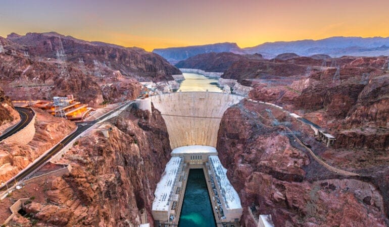
This summer, the U.S. Department of the Interior (DOI) declared the first official water shortage on the Colorado River. The declaration triggers mandatory cuts in withdrawals from the river, which supports more than 40 million people and 4.5 million acres of agriculture across seven U.S. states and two states in Mexico. While the announcement made both history and headlines, it came as no surprise to those in the Colorado River Basin who know the river best—the farmers, water utility managers, tribal leaders, state water management agencies, and others who have witnessed the severe impacts of the region’s decades-long drought and spent years making plans to address it.
“We knew this day would come, and it’s here,” said Brenda Burman, who served as commissioner of the U.S. Bureau of Reclamation, an agency of DOI that manages water in the West, from 2017 to 2021. “We need collective action on the river to address this situation.”
Burman joined former U.S. Secretary of the Interior and Arizona Governor Bruce Babbitt for “Lessons from the Colorado River,” a Lincoln Institute Dialogue hosted by Jim Holway, director of the Babbitt Center for Land and Water Policy, in early September. Their discussion was part of a series of virtual dialogues celebrating the 75th anniversary of the Lincoln Institute. It drew more than 500 registered participants from 43 U.S. states and 19 countries, including Turkey, Bangladesh, Colombia, and Kenya.
“We are at a critical juncture in the Colorado River Basin where we need to rethink our approaches and chart a long-term, sustainable course,” said Holway. “I can think of no one better equipped to help us understand these challenges than Bruce Babbitt and Brenda Burman, who have shaped Colorado River management, as both state and federal leaders, for over 40 years.”
Holway invited Burman to offer an overview of the Colorado River system, current conditions, and the complex 20th and 21st century agreements that govern its usage, including the 1922 Colorado River Compact that allotted water to each of the seven U.S. states in the basin; the 1944 agreement between the United States and Mexico that formalized the latter country’s rights to a share of the water; and the more recent interim guidelines of 2007 and Drought Contingency Plans (DCP) of 2019. The DCP, developed through a series of negotiations among the basin states, NGOs, tribal leaders, and the governments of the United States and Mexico, outlines how stakeholders along the river will share a resource that’s been depleted by a 22-year drought and is vulnerable to long-term climate change.
Both Burman and Babbitt emphasized the importance of a collaborative approach to managing the river. Burman identified the 1990s, and specifically Babbitt’s tenure at DOI (1993–2001), as “the time when we started coming together as a basin to find agreements, to find flexibility, to be able to use this resource.” Babbitt described cooperative management of the river as “a work in progress . . . working together, we’ve managed to come a long way.”
Babbitt was frank about the hard realities of the current situation, outlining serious potential impacts in the Lower Basin (which includes Arizona and parts of California and Nevada). For example, Babbitt said, agricultural operations in central Arizona that no longer have access to river water will pump groundwater instead, which will overtax groundwater reserves and dramatically reduce the amount of agricultural land in production. That shift could also curtail future development in the region because of state requirements that developers demonstrate adequate water supply for their projects. He voiced concern that a political and economic water war could result if speculators accelerate efforts to buy up farmland with senior water rights in other regions, with the goal of selling the associated water rights to others who need water.
Meanwhile, in the Upper Basin (which includes parts of Colorado, Wyoming, New Mexico, and Utah), Babbitt said the sheer number of small water districts is making it difficult to coordinate a response to the drought. He noted that in Colorado, urban areas could be the first to feel the impact of cuts due to the structure of various management agreements. “It isn’t easy to turn off the faucet, because there are so many hands on the faucet,” he said. Still, he struck a cautiously optimistic tone: “These changes don’t happen overnight. There is time still to find a pathway toward a more sustainable balance as these changes take place.”
During the conversation, Babbitt, Burman, and Holway identified several elements of successful watershed management—collaboration, diversity, public engagement, and nonpartisan approaches—and suggested that the Colorado River can serve as a model for other places facing complex resource management problems in an era of climate change. “The lessons we are learning here, and the binational collaborative approaches, serve as examples for other arid and semi-arid river basins throughout the world,” Holway said.
Some of the necessary next steps in the Colorado River Basin include agreeing to additional shortage reductions in individual state water allocations; improving water efficiency; settling outstanding tribal water claims; addressing tribal water infrastructure needs; and establishing fair and equitable water sharing arrangements between agricultural, urban, and tribal water users. The speakers agreed there are promising signs that these steps are achievable, including the ability to agree on previous rounds of Colorado River water cuts; an uptick in wastewater reuse and in local efforts to increase water efficiency and conservation; and growing recognition of the connection between local land use and water management policy. Holway cites Colorado’s Land and Water Planning Alliance as an excellent example of collaboration around actions local government and local water users can take.
As drought and climate change continue to put immense pressure on the Colorado River and other regional water supplies, stakeholders throughout the basin will have to confront not only the current shortage, but also the prospect of more to come. “We are facing a warmer, drier present and a warmer, drier future,” Burman said. “We have a history of coming together, but the time to do more is now . . . . I have a lot of faith that we can do it.”
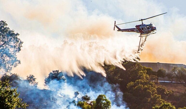
In this summer of 2021, land is being ravaged. Wildfires burn in the western United States, Canada and elsewhere, destroying whole towns and sending smoke across the continent. Meanwhile, the Amazon rainforest has been scorched so extensively for ranching and agriculture that it now emits more carbon than it absorbs.
These alarming events, and the UN’s latest report on rapidly accelerating climate change, underscore the critical role of land, land management, and land conservation in confronting the climate crisis, says Jim Levitt, director of the International Land Conservation Network at the Lincoln Institute of Land Policy.
Sequestering carbon, mitigating heat islands and disasters, maintaining biodiversity, managing water resources stressed by drought—all are crucial jobs that land performs incredibly well, says Levitt, the guest on the latest episode of the Land Matters podcast. And that is why conserving and better managing forests, wilderness areas, and working landscapes is so important now, he says.
“I don’t want to sugarcoat this—it’s going to be a very challenging task,” he says. “It’s a situation, as many people have said before me, that will require all hands on deck.”
Levitt, author of the book From Walden to Wall Street, details latest and best practices in legal structures and conservation finance to step up land protection globally. Land conservation has been part of the Lincoln Institute’s portfolio for decades, but it has special relevance today in the context of global warming.
As part of the 75th anniversary year, the Lincoln Institute is taking a look at a wide range of programs and how they have evolved over the years—and how they are being applied now to some of the world’s most serious problems.
Anthony Flintis a senior fellow at the Lincoln Institute of Land Policy, host of the Land Matters podcast, and a contributing editor of Land Lines.
Photograph: California and other states in the U.S. West are enduring longer wildfire seasons, a trend fueled by climate change. Credit: CAL FIRE via Flickr CC BY-NC 2.0.
An Aerial Survey of Metro Boston Reveals a Regional Food System on the Rise
By Alex MacLean, Junio 23, 2021
SHARE
Across four decades as an aerial photographer, I have been drawn to documenting agriculture for the way it reveals important clues about region, climate, topography, soil, and the passage of seasons and time. This work has increasingly focused on the connections between land use and climate change, as attention to shortening food miles—reducing the distance between producers and consumers, with the goal of lowering carbon emissions and minimizing supply chain disruptions—visibly plays out across rural–urban transects. The images in these pages represent the first steps in an inquiry into how food production in and around urban areas in the United States is changing.
In recent years, the intensification of small-scale growing in the region around Boston, Massachusetts, has been increasingly apparent. From the air, I’ve seen hoop houses spring up on small farms seeking to meet demand and expand productivity; I’ve seen drab commercial and residential rooftops become vibrant gardens; I’ve seen historically nonproductive urban land like vacant lots and lawns become cultivated spaces. When added up, these small-scale operations seem to hold real potential for productivity gains through the power of increments. Green spaces in and near urban areas don’t just provide people with fresher, more accessible food; by filtering stormwater, absorbing carbon dioxide, and providing other environmental benefits, they can also make cities healthier, more resilient places.
Despite these promising changes, what is commonly understood as the locavore movement has done more to create a sense of place, build community, and educate around food than it has to increase food security or shorten food miles at the scale necessary to confront climate change. While demand and enthusiasm for local food has grown over the last decade, an estimated 90 percent of food in the Boston metro area comes from outside the region, according to Food Solutions New England (FSNE), a regional network based at the nearby University of New Hampshire. But policy makers, investors, farmers, and entrepreneurs in the area are working to change that, and FSNE is advocating for “50 by 60”—referring to the percentage of food that could be regionally sourced by 2060.
One trend that could help reach that goal, also visible from the air, is indoor farming. Most commonly located in undervalued industrial neighborhoods, indoor farms use technologies like hydroponics and LED lighting to enable year-round cultivation. The companies behind them are increasingly demonstrating that a lack of open space does not have to be a constraint on food production. The indoor farming industry attracted $1.9 billion in global venture capital in 2020, three times the amount committed in 2019.
Boston is home to some of the companies gaining the most momentum. Freight Farms, for instance, further democratizes proximity to production through the use of retrofitted shipping containers that can be tucked beneath elevated highways or squat next to school cafeterias. In 320 square feet, these containers yield as much produce as two cultivated acres. Such innovative solutions give insight into what alternative growing can look like as climate change degrades farmland and shrinks water supplies. However, indoor farming has its drawbacks; it can be energy intensive and, although its yields are often marketed as “local,” in some senses it replicates the centralization and corporate influence against which local and regional agriculture advocates have long chafed.
As an aerial photographer, I hope some form of outdoor food production will always be integrated into our landscapes. Whether viewed from the ground or from the air, farms and fields help us understand the key elements of the natural world that sustain us, providing a connection to the planet and an impetus to protect these places. But from above, it is increasingly apparent that a reimagining of agricultural systems is underway, and that we will need many different approaches for “local food” to evolve into an equitable model of regional food sovereignty.
The Boston metro region imports 90 percent of its food from outside the region. Above, box trucks and refrigerated trailer units line the New England Produce Center warehouses in Chelsea, just north of downtown Boston. Among the largest wholesale produce markets in the world, the complex receives shipments from across the United States and internationally. Produce is then redistributed to food outlets throughout New England and southeastern Canada. Credit: Alex MacLean.
The renowned Fenway Victory Gardens along the Muddy River in Boston’s Back Bay are made up of over 500 plots that remain on land that was dedicated to food production during World War II. Fenway was one of over 20 million victory gardens across the country that contributed to growing roughly 40 percent of the nation’s produce at the height of the war. The history speaks to the potential to adapt and to grow local produce on a large scale. Credit: Alex MacLean.
The community garden at the First Parish Church in Lincoln, Massachusetts, seen in four seasons. Changes in the garden throughout the year are a time marker that affirms our awareness as we transition through seasons. Parishioners grow individual plots and collectively grow a donation plot that provides an average of 600 pounds of food each year to Boston-area homeless shelters and soup kitchens. Credit: Alex MacLean.
The Largest of Mill City Grows’ four farms, “Big Farm” is situated on 2.8 acres leased from the city of Lowell, Massachusetts. The food from these farms is distributed through mobile markets, a Community Supported Agriculture farm share program, and donations. In working toward local food justice, Mill City Grows also partners with schools to support educational and community growing initiatives. Credit: Alex MacLean.
The city of Lawrence, Massachusetts, helped establish the Cross and Cedar Street Garden in 2011. The garden, which is tended by local residents, occupies two vacant lots where dilapidated housing had been torn down. Raised beds help protect against the hazards of contaminated soil. Credit: Alex MacLean.
The Nightingale Community Garden in Dorchester, Massachusetts, owned by statewide conservation organization The Trustees, is part of a citywide initiative to increase access to local produce, and to make community gardens a prominent feature of unbuilt urban spaces. Credit: Alex MacLean.
Planted terraces on top of The Esplanade, a condominium complex in Cambridge, Massachusetts, demonstrate the potential for commercial roof spaces to accommodate urban agriculture. Credit: Alex MacLean.
Chicken tractors and containment pens are moved each day at Codman Community Farms in Lincoln, Massachusetts, one of the sustainable practices that goes into producing 800 to 1200 eggs per week. Located 15 miles northwest of Boston and dating back to 1754, the farm sits on 18 acres. An additional 120 acres of fields and pastures scattered throughout the town provide hay for livestock and open spaces for those living in the surrounding area. Credit: Alex MacLean.
Over 95 percent of greens consumed on the East Coast come from California and Arizona, often spending over a week in transit. Little Leaf Farms is working to disrupt reliance on West Coast produce through year-round hydroponic growing in a 10-acre greenhouse in Devens, Massachusetts, 40 miles west of Boston. The growing process is entirely automated; greens are planted and harvested without touching human hands. The company’s success thus far has brought in $90 million in debt and equity financing to expand operations down the East Coast, beginning in Pennsylvania and North Carolina. Credit: Alex MacLean.
Freight Farms manufactures vertical hydroponic greenhouses inside 40-foot shipping containers. Equipped with precise climate control and optimized lighting for select plants, the containers can yield up to two acres of conventionally grown produce in 320 square feet. The mobile greenhouses can be placed anywhere, such as beneath highway underpasses or adjacent to schools. Credit: Alex MacLean.
Built on what was once a contaminated brownfield site in Providence, Rhode Island, Gotham Greens—the white structure at bottom left of image—provides New England with year-round hydroponically grown greens and herbs. The greenhouse is powered by renewable electricity and uses 95 percent less water and 97 percent less land than conventional agriculture. Credit: Alex MacLean.
Gaining Ground Farm in Concord, Massachusetts, grows produce for Boston-area shelters and food pantries. Using high tunnels, hoop houses, row covers, and soil nourishment, Gaining Ground has increased production by over 100 percent over a four-year period. In 2020, Gaining Ground grew and donated 127,429 pounds of produce, compared to 61,764 in 2016. This photograph, taken in 2016, shows the farm’s early adoption of hoop houses. Credit: Alex MacLean.
This photograph, taken in 2020, shows the intensification of production at Gaining Ground Farm in Concord, Massachusetts. Gaining Ground, which grows produce for Boston-area shelters and food pantries, more than doubled the amount of food it grew and donated between 2016 and 2020. Credit: Alex MacLean.
This community garden in Allston-Brighton, Massachusetts, is on land owned by the state Department of Conservation and Recreation. The mid-October foliage foretells the end of the growing season and the onset of winter. Credit: Alex MacLean.
Alex MacLean is a pilot and internationally exhibited photographer whose work has appeared in Land Lines and the Lincoln Institute book Visualizing Density. He specializes in documenting changes to the land brought about by human intervention and natural processes.
Lead Image: Boston’s community gardens have created a stronger sense of place within city neighborhoods. The Worcester Street Community Garden in Boston’s South End is one of 56 community gardens owned by The Trustees. Managed by volunteers, the Worcester Street garden has more than 130 plots available to Boston residents on a first-come, first-served basis. Credit: Alex MacLean.
A Cartographic Meditation
Mapping the Colorado River Basin in the 21st Century
Where is the Colorado River Basin? A novice attempting a cursory Google search will be surprised—and perhaps frustrated, confused, or a little of both—to find that there is no simple answer to that question. Winding through seven U.S. states and two states in Mexico—and supporting over 40 million people and 4.5 million acres of agriculture along the way—the Colorado River is one of our most geographically, historically, politically, and culturally complex waterways. As a result, creating an accurate map of the basin—the vast area of land drained by the river and its tributaries—is not a simple undertaking.
Commonly used maps of the region vary widely, even on basic details like the boundaries of the basin, and most haven’t kept up with changing realities—like the fact that the overtapped waterway no longer reaches its outlet at the sea. At the Babbitt Center, we began to hear a common refrain as we worked on water and planning integration efforts with stakeholders throughout the West: people frequently pointed out the flaws in available maps and suggested that addressing them could contribute to more effective water management decisions, but no one seemed to have the capacity to fix them. So, with the help of the Lincoln Institute’s newly established Center for Geospatial Solutions, we embarked on a mapping project of our own.
Our newly published peer-reviewed Colorado River Basin map seeks to correct several common errors in popular maps while providing an updated resource for water managers, tribal leaders, and others confronting critical issues related to growth, resource management, climate change, and sustainability. It is a physical and political map of the entire Colorado River Basin, including the location of the 30 federally recognized tribal nations; dams, reservoirs, transbasin diversions, and canals; federal protected areas; and natural waterways with indications of year-round or intermittent streamflow. We are making the map freely available with the hope that it will become a widely used resource, both within the basin and beyond.
Challenges, Choices, and Rationale
Even though they have few words, maps still speak. All maps are somewhat subjective, and they influence how people perceive and think about places and phenomena. During the peer review process for our new map, one reviewer asked whether our purpose was to show the “natural” basin or the modern, aka engineered and legally defined, basin. This seemingly simple question raised several fundamental questions about what a “natural” basin actually is or would be. This struck us as akin to a perennial question facing ecological restoration advocates: to what past condition should one try to restore a landscape?
In the case of the Colorado, this question becomes: when was the basin “natural”? Before the construction of Hoover Dam in the 1930s? Before Laguna Dam, the first dam built by the U.S. government, went up in 1905? The 18th century? 500 years ago? A million years ago? In an era when the human–natural binary has evolved into a more enlightened understanding of socioecological systems, these questions are difficult to answer.
We struggled with this quandary for some time. On the one hand, representing a prehuman “natural” basin is practically impossible. On the other hand, we felt an impulse to represent more of the pre-dam aspects of the basin than we typically see in conventional maps, which often privilege the boundary based on governmental contrivances of the 19th and 20th centuries.
Ultimately, after multiple internal and external review sessions, we agreed on a representation that does not attempt to resolve the “natural” versus “human” tension. We included infrastructure, clearly showing the highly engineered nature of the modern basin. We also included the Salton Basin and Laguna Salada Basin, two topographical depressions that were formed by the Colorado. Both are separate from the river’s modern engineered course, and often excluded from maps of the basin. We didn’t choose to show them because we expect the Colorado River to jump its channel any time soon, nor because we presume to accurately represent how the delta looked prior to the 20th century. But from our research, we learned that the 1980s El Niño was of such magnitude that river water from the flooded lower delta reached back up into the dry bed of the Laguna Salada, making commercial fishing possible there. Environmental management of the heavily polluted Salton Sea, meanwhile, is a contested issue that has figured in recent discussions about future management of the Colorado. These areas are not hydrologically or politically irrelevant.
Our map doesn’t attempt to answer every question about the basin. In many ways, our contribution to Colorado River cartography highlights the unresolved tensions that define this river system and will continue to drive the discourse around water management and conservation in the Colorado Basin.
There is no simple definition of the Colorado River Basin. That might be the most important underlying message of this new map.
Zachary Sugg is a senior program manager at the Babbitt Center for Land and Water Policy.
The Lincoln Institute's Native American Graduate Fellowship Program assists students pursuing master's degree studies in water and/or land use management, who seek to apply the expertise and skills gained to advance water resilience in tribal communities. Fellowships are open to students who are a member of a Tribe in the Colorado River Basin attending any university; or a member of a Tribe outside the Basin region attending a university located within any of the Basin states in the U.S. or Mexico (Arizona, California, Colorado, Nevada, New Mexico, Utah, Wyoming, Sonora, or Baja California).
Applications are accepted online, by email, or by regular mail. Please refer to application guidelines for complete information.
Detalles
Submission Deadline
July 1, 2021 at 11:59 PM
Descargas
Palabras clave
planificación ambiental, la región intermontañosa del oeste, planificación de uso de suelo, planificación, agua, planificación hídrica
Preguntas a expertos
Concebir la resiliencia ante el cambio climático
Enero 12, 2021
SHARE
Expertos de la red del Instituto Lincoln responden a la pregunta: Si en 2021 pudiera implementar una solución basada en el suelo que tenga un impacto considerable en el cambio climático, ¿cuál sería?
Cortesía de Robin Bronen.
Robin Bronen
Directora ejecutiva del Instituto para la Justicia de Alaska; miembro del Comité Director de Climigration Network
Devolver las tierras robadas a los pueblos originarios y eliminar las fronteras y los límites que dividen y separan los ecosistemas de los cuales dependemos. Los pueblos originarios conservan la biodiversidad del planeta desde hace milenios. El 25 por ciento del suelo que ellos ocupan en el planeta coincide con el 40 por ciento de las zonas naturales protegidas y los territorios que aún no están dañados. Según los estudios realizados por el Banco Mundial, estos territorios albergan el 80 por ciento de la biodiversidad del planeta. En los Estados Unidos, el colonialismo de asentamientos creó estructuras legales e institucionales que echaron y reubicaron por la fuerza a poblaciones originarias de sus tierras tradicionales y reestructuraron sus tierras como propiedad y como recurso. La repatriación de estas tierras a los pueblos originarios, en su calidad de administradores de estas tierras que hoy se denominan Estados Unidos, ayudaría a rectificar esta injusticia. Al eliminar la construcción social de las fronteras y los límites que dividen el suelo de forma artificial y quitar esas líneas invisibles, los ecosistemas y la biodiversidad de los cuales depende la humanidad podrían prosperar al mismo tiempo que la crisis climática transforma la red de la vida.
Cortesía de la Sociedad Estadounidense de Arquitectos Paisajistas.
Kongjian Yu
Fundador y presidente de Turenscape; colaborador de Nature and Cities
La solución más efectiva y holística para el cambio climático son los “suelos esponja”. Esta solución basada en el suelo expande el concepto de “ciudades esponja”, que usa infraestructura verde para absorber agua pluvial y combatir la contaminación en zonas urbanas. Con ella, se puede retener agua de lluvia en la fuente, detener su curso cuando fluye y usarse de forma flexible en su salida (ya sea un río, lago u océano). Esta alternativa es totalmente opuesta a las soluciones convencionales de ingeniería de uso extendido en todo el planeta, en particular en países en vías de desarrollo con monzones: hacer diques en los ríos para crear grandes embalses, canalizar agua con muros antiinundación de concreto, construir drenajes de concreto en la ciudad y bombear el agua hacia afuera. La infraestructura gris consume grandes cantidades de cemento y crea grandes cantidades de emisiones de carbono, sofoca los ecosistemas más productivos con la mayor biodiversidad y los hacen menos resilientes.
Los suelos esponja consisten en la generación de porosidad en paisajes vastos y montañosos que sufren erosión; la creación de “campos esponja” en forma de estanquecitos en tierras agrícolas donde la escorrentía contamina los ríos y lagos cercanos; y la creación de ciudades esponja. El concepto de suelo esponja significa usar con prudencia el cemento para ingeniería hidrológica y el pavimento en zonas urbanas. También significa quitar los muros antiinundación de concreto y los diques de vías fluviales para restaurar el hábitat, reabastecer agua subterránea, obtener vegetación frondosa y promover otros beneficios. Los suelos esponja son una solución eficiente y poco costosa que fortalecerá la capacidad de resistencia del suelo ante el cambio climático.
Cortesía de la Universidad Cornell.
Linda Shi
Profesora adjunta de Planificación Regional y de Ciudades, Universidad Cornell; disertante de la beca a la investigación C. Lowell Harriss entre 2015 y 2016
Los Estados Unidos necesitan un plan nacional de adaptación climática que incluya una estrategia de uso y desarrollo del suelo. Las labores relacionadas con la eliminación del dióxido de carbono y las energías renovables, como biocombustibles y paneles solares, tendrán un gran impacto en el uso del suelo rural. Si no se logra descarbonizar, se escalarán los impactos climáticos, la migración causada por el clima y los nuevos entornos de injusticias en forma de oasis climáticos y asentamientos informales. El creciente conflicto político urbano y rural ya refleja las desigualdades espaciales y socioeconómicas, cuyas raíces son la extracción de recursos y personas rurales para los procesos de urbanización, dinámicas que la crisis climática puede exacerbar. Las respuestas del mercado no serán suficientes a escala, no apuntarán a geografías que puedan admitir crecimiento de forma sostenible ni permitirán una transición climática justa. Por lo tanto, la magnitud de las acciones necesarias para afrontar la crisis climática exige una nueva arquitectura nacional de políticas de suelo. Esto incluye: (1) identificación de geografías, con base en la ciencia y en la igualdad, donde se deban aplicar el crecimiento y las inversiones del futuro; (2) políticas fiscales, de inversión y de subsidios que permitan a los gobiernos locales responder a los efectos del cambio climático, en vez de cargarlos con mandatos sin financiamiento o medidas punitivas; y (3) reformas legales a regulaciones bancarias y organizativas que expandan los modelos de posesión cooperativa y ayuden a aumentar el control comunitario de las viviendas y el suelo para retener y crear riquezas locales.
La zonificación de los barrios periféricos de los Estados Unidos propició un entorno suburbano dominado por casas unifamiliares grandes en lotes extensos, y amplias zonas (que suelen estar vacantes) de uso industrial y de oficinas. Así, se promovió un patrón autodependiente de población y centros de empleo muy dispersos que, a su vez, ocasionó mayores emisiones por viajes en vehículo, además de uso de energía para iluminación, calefacción y refrigeración. También restringió la construcción de viviendas, exacerbó los problemas de capacidad de pago y causó que millones de trabajadores de ingresos más bajos hicieran viajes largos todos los días para ir de los centros urbanos a su empleo en los suburbios. Las soluciones son directas y no requieren que se deshaga la zonificación de viviendas unifamiliares. Los estatutos de zonificación de los estados deberían exigir a los municipios que admitan departamentos y estructuras complementarios en zonas de viviendas unifamiliares siempre que sea posible desde un punto de vista de salud y seguridad; permitan viviendas multifamiliares en corredores comerciales y en zonas industriales o de oficinas; y rezonifiquen predios vacantes que fueron salteados para viviendas multifamiliares (en casi todos los suburbios del país hay decenas de ellos). Una mayor densidad residencial en corredores y núcleos de uso mixto, a su vez, aumentará en gran medida las oportunidades para soluciones de transporte eficientes y rentables. Ampliar y diversificar las opciones de vivienda en suburbios que ya están muy desarrollados es responder a necesidades de vivienda insatisfechas y reducir la presión para que los subterráneos se expandan hacia afuera. De esta manera, los suburbios en sí serán más sostenibles ante cambios demográficos, ante la demanda de viviendas y ante futuros impactos climáticos.
Cortesía de Sivan Kartha.
Sivan Kartha
Científico sénior en el Instituto Ambiental de Estocolmo; asesor en el programa climático del Instituto Lincoln
En una encuesta a 64 países, se calculó que los bosques que pertenecen a pueblos originarios y comunidades forestales en conjunto contienen el equivalente a alrededor de un billón de toneladas de dióxido de carbono, lo cual equivale a más de tres décadas de emisiones por uso de combustibles fósiles en todo el mundo. Además, estas tierras son de las más ricas en biodiversidad y albergan recursos vitales de agua potable. Sin embargo, los derechos territoriales de quienes viven en esos bosques no suelen estar reconocidos formalmente. Los países con abundantes bosques suelen tener legados colonialistas: las tierras y los recursos se tomaron por la fuerza en detrimento de las comunidades locales. Aún se conservan derechos a la propiedad seculares y regímenes de tenencia de suelo que, originalmente, se establecieron para fines impositivos y de extracción, lo que acrecentó el deterioro constante de los recursos de los bosques. Cada vez más investigaciones demuestran que, cuando los derechos territoriales se reconocen formalmente y se salvaguardan por medios legales, los pueblos originarios y las comunidades locales pueden proteger recursos comunes mediante prácticas informales y acciones colectivas que evitan la deforestación, preservan la biodiversidad y protegen servicios de ecosistemas, como enriquecimiento del suelo y salud de las cuencas. Por el contrario, si se imponen regímenes convencionales de propiedad privada, pueden surgir nuevos problemas, se dispara la especulación territorial y se desafían las normas culturales locales. Al establecer derechos de tenencia territorial seguros para los pueblos originarios y las comunidades rurales, se podrían preservar mejor los recursos de los bosques del mundo, que se están reduciendo. A la vez, se podría salvaguardar el sustento del cual dependen cientos de millones de residentes.
Cortesía de Tamika Butler.
Tamika Butler
Asesora de entornos construidos e igualdad en TLB Consulting; oradora invitada en el Instituto de Planificadores de Grandes Ciudades
Para 2021, lo que anhelo es que el aumento de atención, debates y asignación de recursos con relación a la lucha contra el racismo, la supremacía blanca y los movimientos antinegros no desaparezcan con el cambio de año y con el esfuerzo de la gente por “volver a la normalidad”. No debería alcanzar con solo estar mejor de cómo estamos ahora. Como persona negra, con solo ver las estadísticas sabría que la antigua normalidad implicaba que mi vida era prescindible. Como persona negra, también sé que en esta nueva normalidad, con solo ver cualquier estadística sobre COVID-19, crímenes de odio o racismo medioambiental, sabría que mi vida sigue siendo prescindible. Además de que no alcanza, “volver a la normalidad” no tendrá un impacto significativo sobre el cambio climático. Por el contrario, anhelo que quienes están en el poder examinen a quiénes están oyendo y financiando cuando se trata de soluciones basadas en el suelo.
Las ideas, soluciones e indagaciones para combatir el cambio climático con soluciones basadas en el suelo deberían centrarse en procurar que escuchemos a las personas negras, representantes de pueblos originarios y otras personas racializadas y miembros de grupos históricamente oprimidos que desde hace mucho lideran el cambio climático, la sustentabilidad y la lucha por proteger a la humanidad. Todas las soluciones para el cambio climático deberían centrarse en la idea de que en 2021 debemos dejar de matar a la gente negra, de pueblos originarios, y a otras personas de color.
Implementar cargos por desarrollo con componentes medioambientales podría tener un impacto considerable en el cambio climático. Se trata de permisos urbanos o de construcción que tienen en cuenta aspectos hídricos y de vegetación para ejercer derechos básicos o adicionales de construcción. Para ilustrar el último caso, añadir suelo para espacios urbanos verdes a cambio de un aumento de densidad podría ser un cargo adicional. Estas herramientas de planeamiento urbano podrían financiar la adaptación y la mitigación ante el cambio climático porque podrían generar recursos a nivel local para financiar la conservación o implementación de infraestructura verde y azul en espacios públicos y privados. Se priorizarían las soluciones basadas en la naturaleza. La naturaleza puede ofrecer soluciones más asequibles a largo plazo y más beneficiosas para humanos y ciudades que las que solo usan infraestructura gris. Al mismo tiempo, dichas soluciones pueden funcionar como medidas de mitigación y adaptación.
En general, estos requisitos se deberían aplicar en el mismo lugar donde se construye, en forma de drenaje sostenible, reforestación o espacios verdes. En casos excepcionales, implicarían financiar infraestructura verde en otro lugar. Se pueden adjuntar condiciones medioambientales a derechos de construcción de distintas formas, según los efectos locales del cambio climático y la magnitud del proyecto de desarrollo urbano. El planeamiento urbano, la ley y la regulación de la propiedad privada tienen una función importante frente al cambio climático.
Cortesía de la Universidad de Pensilvania.
Frederick Steiner
Decano en la Facultad de Diseño Stuart Weitzman de la Universidad de Pensilvania; coeditor de Design with Nature Now
Mientras trabajamos para promulgar políticas efectivas, debemos cambiar el modo de sentir y pensar el cambio climático y adaptar nuestro estilo de vida en consecuencia. Cualquier persona que lea esto debería hacer una lista con 365 actividades personales que afectan el cambio climático y comprometerse a reemplazar una por día con una acción que mitigue el cambio climático o se adapte a él. Si comparten la promesa en redes sociales, podrían alentar a familiares, amigos y seguidores a hacer lo mismo. Todas estas acciones se vinculan con el suelo, el agua y la energía. Por ejemplo:
usar una fotocopiadoraplantar un árbol construir un patiohacer un jardín conducir un automóvilsalir a caminar quejarse de los políticosllamar y escribir a representantes encargar un libro en líneavisitar una librería local comprar productos agrícolas importadoscultivar un tomate llevar ropa a la lavanderíaaprender a planchar asar carnecomer un grillo ir en avión a una conferenciaorganizar un evento por Zoom encender el aire acondicionadoabrir una ventana cortar el céspedplantar flores nativas actualizar el plan del cableobservar aves
y así durante 353 días más.
Cortesía de IGC.
Astrid R. N. Haas
Directora de políticas en el Centro Internacional de Crecimiento
Desde una perspectiva gubernamental, implementar soluciones basadas en el suelo en mi país, Uganda, es un desafío en sí mismo. Esto se debe, en parte, a que la Constitución y todos los instrumentos legislativos subsiguientes relativos al suelo indefectiblemente otorgan el suelo a la gente. Además, Uganda tiene varios sistemas de tenencia coexistentes, y a la vez escasa capacidad administrativa para delinear cada uno de ellos o documentar la posesión. Esta situación limita la capacidad del gobierno de implementar soluciones basadas en el suelo que destraben el valor público. Por lo tanto, es en este contexto que en 2021 yo pensaría en el reajuste de suelo como en un enfoque totalmente práctico y la solución basada en el suelo más viable. En particular en zonas urbanas, esta herramienta tiene un potencial enorme [se trata de un modelo en que los propietarios reúnen sus propiedades para concretar un proyecto de redesarrollo]. Por ejemplo, al trabajar a nivel local, se podría determinar la tenencia y la propiedad del suelo y lograr que la comunidad adquiera predios agrupados para ejecutar desarrollos de mayor densidad. Hay cada vez más evidencia de que las ciudades con mayor densidad son más ecológicas y más eficientes con respecto al cambio climático. Por lo tanto, esta solución tendría un impacto importante no solo en la eficacia del modo en que se pueden gestionar las ciudades de Uganda (en particular en lo que respecta a proveer servicios públicos), sino también en el cambio climático.
Cortesía de IAAO.
Larry Clark
Director de iniciativas estratégicas en la Asociación Internacional de Funcionarios Tasadores
Soy un valuador con 40 años de experiencia en tres jurisdicciones locales; escribo artículos, doy conferencias y enseño valuación masiva en muchas partes de los Estados Unidos y el mundo. Gracias a mi vínculo con personas de todas partes del mundo, logré entender los problemas que conlleva el cambio climático. Una de las realidades es que los recursos hídricos están mal distribuidos en los 50 estados. El cambio climático exacerba esa situación porque provoca sequías en una parte del país, y en otra el aumento de temperatura provoca lluvias intensas e inundaciones. Por lo tanto, mi deseo sería desarrollar una red nacional de embalses y sistemas de distribución para recolectar y redistribuir las precipitaciones en todo el país. Se requeriría un esfuerzo de alcance similar al sistema federal de autopistas que comenzó con el presidente Eisenhower, que debería regir un organismo regulador que priorice las necesidades humanitarias por sobre las agrícolas y comerciales. Los sistemas de recolección deberían ubicarse en las zonas inundables actuales y previstas para el futuro, así como en las de escorrentía natural, para que el agua rellene embalses y luego se distribuya a sistemas hídricos municipales que la necesiten.
Cortesía de la Universidad Texas A&M.
Forster Ndubisi
Profesor de arquitectura paisajística y planeamiento urbano en la Universidad Texas A&M; autor de Ecology in Urban Design and Planning
Las soluciones ante el cambio climático exigen que volvamos a pensar los fundamentos de nuestras relaciones éticas con el suelo. Propongo que iniciemos el proceso de reflexión crítica sobre nuestras obligaciones éticas para con el suelo y en 2021 adoptemos la ética ecocéntrica con base en el lugar (PBEE, por su sigla en inglés) como una solución para el cambio climático. La adopción de la PBEE mediante educación de inmerión a largo plazo estipula la conducta ética y las obligaciones morales que deberían adoptar diseñadores y planificadores al abordar los desafíos del cambio climático. La PBEE se basa en la interdependencia entre la gente y los procesos biofísicos [de la naturaleza], que plantea una dependencia mutua entre ambos componentes para que puedan seguir existiendo. El resultado indefectible de la interacción humana con los procesos naturales es cierto deterioro de los recursos y procesos naturales [capital natural], como paisajes que ofrecen servicios vitales de ecosistemas. Por lógica, la PBEE establece el mandato moral de preservar el capital natural cuando sea posible; conservarlo cuando se demuestre un grado justificable de uso; reabastecerlo mediante restauración natural de ecosistemas deteriorados; minimizar el alcance de la huella humana; reducir el uso de carbono y adoptar de forma activa la administración medioambiental. Para combatir el cambio climático con eficacia, la PBEE utiliza los conocimientos ecológicos como un proceso para comprender la interdependencia entre el ecosistema humano y el natural. A su vez, los conocimientos ecológicos funcionan mejor si se usa un proceso de ideas que considere los sistemas y el diseño, y si se colabora de forma participativa para crear soluciones que mitiguen el cambio climático y se adapten a él.
Teniendo en cuenta los impactos socioeconómicos de la pandemia de COVID-19, se necesitan soluciones tanto locales como metropolitanas para prevenir impactos no deseados en el medioambiente, como la contaminación, la acumulación de basura y la reducción de áreas verdes. Las ciudades deben tener conectividad, pensamiento sistémico y sostenibilidad metropolitana. Las ciudades deben implementar tanto una economía circular como una tributación circular, para fortalecer los impuestos inmobiliarios y ambientales, y permitir respuestas locales más rápidas, efectivas y eficientes. Estos sistemas también pueden propiciar una reducción de la corrupción, una mejor calidad de vida y la mitigación de los cambios climáticos. Con el objetivo de lograrlo, proponemos un impuesto circular, una herramienta fiscal inteligente para la construcción y el desarrollo de ciudades y regiones metropolitanas. Esto implica el fortalecimiento de la tributación inmobiliaria (impuesto predial, tributación diferenciada por uso y ubicación, impuesto a las mejoras) y de los impuestos ambientales (tasas de recolección y reciclaje de basura, impuesto sobre amenazas ambientales metropolitanas, aplicación del principio de quien contamina paga). Un impuesto circular fortalecería la planificación y la gestión urbana sostenible y es una política territorial que puede ayudar a preservar el medioambiente.
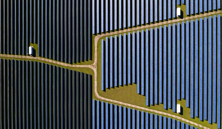
Fotografía: Vista aérea de una central solar en Alemania. Crédito: Bim/Getty Images.
Water & Tribes Initiative Encourages Collaborative Approach to Colorado River Management
Por Matt Jenkins, Enero 12, 2021
SHARE
E
n el otoño de 2018, los gestores hídricos de Arizona debatían acaloradamente sobre cómo limitar los daños de una megasequía en el río Colorado que duró décadas. La sequía forzó cálculos y reajustes penosos en el uso del agua en toda la cuenca del río. Debido al modo en que se fue asignando el agua a través del tiempo, se hizo evidente que Arizona pagaría los platos rotos de la inminente escasez, y que los agricultores del estado, de los cuales muchos tienen derechos hídricos de baja prioridad, se enfrentarían a recortes graves.
En una reunión de octubre de ese año, Stefanie Smallhouse, presidenta de la Oficina Agrícola de Arizona, denunció los cortes propuestos. Sugirió que las propuestas eran una falta de respeto a los agricultores, en particular para un colono blanco llamado Jack Swilling que, según dijo, de forma heroica había hecho florecer el desierto. “Me resulta irónico que estemos exactamente a 150 años del primer agricultor que comenzó el asentamiento en la zona de Phoenix”, dijo Smallhouse. “Allí no había nadie más. Había reliquias de actividad agrícola de las tribus en el pasado, pero [Swilling] fue prácticamente quien empezó todo”.
Más tarde habló Stephen Roe Lewis en la reunión. Lewis es el gobernador de la comunidad indígena del río Gila, una reserva al sur de Phoenix que alberga a miembros de las tribus akimel o’otham y pee posh. El patrimonio de los akimel o’otham se remonta a la civilización hohokam, que a partir de unos 1.400 años atrás construyó un sistema masivo de canales de irrigación para atender los cultivos de algodón, maíz y otros vegetales en la zona. Pero en las décadas de 1870 y 1880 se construyeron nuevos sistemas, y el río Gila quedó drenado. Estos sistemas nuevos estuvieron a cargo, principalmente, de agricultores blancos, y además de asolar las granjas de los akimel o’otham y pee posh, provocaron hambrunas. “La historia es importante”, afirmó el gobernador Lewis, y corrigió el relato de Smallhouse sobre que Swilling solo halló “reliquias” de agricultura de las tribus. “Hace más de 1.000 años que cultivamos, y el único momento en que eso se interrumpió fue cuando nos quitaron el agua”.
De hecho, la comunidad indígena del río Gila ha dedicado gran parte de los últimos 150 años a intentar recuperar el agua de la cual sus miembros dependieron durante tanto tiempo. En 2004, un acuerdo aprobado por el Congreso otorgó a la comunidad una cantidad importante de agua del Colorado. Desde entonces, esta ha trabajado activamente para proteger esos derechos. “Estaremos aquí todo el tiempo que sea necesario para hallar soluciones”, dijo Lewis a las partes reunidas en 2018. “Pero lucharemos hasta el final para procurar que no se vuelvan a llevar nuestra agua”.
Tal como demuestra ese intercambio, la larga historia de los nativos estadounidenses en la cuenca del río Colorado se suele ignorar en los debates sobre la gestión del recurso, al igual que sus vínculos sociales, culturales y medioambientales con el río. Los comentarios de Lewis indican el compromiso que tienen hoy los dirigentes tribales para cambiar eso. Desde fines de la década de 1970, las tribus de la región han ganado una serie de acuerdos que confirman sus derechos sobre el agua del río Colorado. Hoy, controlan alrededor del 20 por ciento del agua del río. Ante la realidad de la severa escasez en toda la cuenca, se hizo evidente que en toda conversación que ocurra sobre el futuro, las tribus deben ser piezas claves, porque poseen soberanía bajo la Constitución nacional, lo cual les da derecho a gobernarse a sí mismas.
Lo que está en juego no es poco, no solo para las tribus, sino también para todas las personas que dependen del Colorado. Unas 41 millones de personas de siete estados de los Estados Unidos y dos de México usan el agua del río, que irriga más de un millón y medio de hectáreas de tierras agrícolas. Si la cuenca del Colorado fuera un país aparte, sería una de las 10 mayores economías del mundo. Pero las sequías y otros efectos del cambio climático están excediendo la capacidad del río de suplir las enormes demandas que tiene; así, las tribus llegan de forma más directa a la política del río.
Para mejorar la capacidad de las tribus de gestionar el agua y fortalecer su voz en los debates y decisiones sobre gestión de la cuenca, en 2017 varias organizaciones formaron la iniciativa Water & Tribes (WTI, por su sigla en inglés), con financiación del Centro Babbitt para Políticas de Suelo y Agua, un programa del Instituto Lincoln. Ahora, el proyecto también recibe financiación de las fundaciones Walton Family y Catena y otros asociados; lo dirige un grupo diverso de representantes tribales, funcionarios y exfuncionarios estatales y federales, investigadores y grupos conservacionistas, entre otros.
“Si trabajamos juntos, podremos hallar soluciones a estos problemas”, dice Daryl Vigil, miembro del pueblo jicarilla apache y cofacilitador de la WTI. Él dice que es un momento delicado para las tribus: “Si no nos adelantamos al juego, en términos de apenas un reconocimiento básico de soberanía tribal en el proceso, los riesgos serán inmensos”.
“Nos entusiasma ser parte de esta asociación que evoluciona y crece”, dice Jim Holway, director del Centro Babbitt. “El trabajo que hace la WTI es esencial para la sostenibilidad de la cuenca a largo plazo, y es fundamental para nuestro objetivo de mejorar los vínculos entre la gestión del agua y el suelo”.
Aguas divididas
Las 29 tribus con reconocimiento federal en la cuenca del río Colorado viven en una paradoja desde hace mucho tiempo. En 1908, la Corte Suprema de los Estados Unidos determinó que las tribus tienen derecho a agua para sus reservas. En la jerarquía por orden de llegada de la ley hídrica occidental, la Corte les jugó un poderoso as bajo la manga: determinó que los derechos hídricos de una tribu se basaban en la fecha de creación de la reserva. Dado que casi todas ellas fueron creadas por el gobierno de los Estados Unidos en la segunda mitad del s. XIX, en teoría están en una situación más favorecedora que cualquier otro usuario del río. Al igual que los akimel o’otham y los pee posh, todas las tribus estaban allí desde mucho antes que los colonos no nativos.
Pero cuando los representantes de los siete estados de la cuenca se reunieron en 1922 para redactar el convenio del río Colorado, empujaron a las tribus hacia el fondo. El convenio especifica la división del agua entre California, Arizona, Nevada, Colorado, Wyoming, Utah y Nuevo México, y sentó las bases para una red compleja de acuerdos, leyes y resoluciones judiciales que se conocen de forma colectiva como “la ley del río”, que, básicamente, ignoró a los indígenas (si desea estudiar con mayor profundidad sobre el río y su historia, consulte la edición especial de Land Lines de enero de 2019). Si bien el convenio reconoce escuetamente “las obligaciones de los Estados Unidos para con las tribus indígenas del país”, no entra en detalle sobre los derechos hídricos de estas. Como indicó el académico Daniel McCool: “al haber omitido la consideración de los derechos de los indígenas, se dejó sin resolver uno de los problemas más importantes de la cuenca” (McCool 2003).
El escritor e historiador Philip Fradkin llevó esta idea un poco más allá al declarar que “en esencia, el Colorado es un río de blancos”. Pero indicó que los colonos angloamericanos ignoraron a los indígenas bajo su propio riesgo: el problema no resuelto de los verdaderos derechos indígenas sobre el agua del Colorado fue una “espada de Damocles” que pendía sobre el futuro del río (Fradkin 1996).
Aún no se ha cuantificado todo el alcance de los derechos hídricos de los indígenas. A principios de la década de 1970, las políticas federales tomaron un rumbo radicalmente nuevo y adoptaron el principio de la autodeterminación de las tribus. Así, las tribus negociaron directamente con el gobierno federal para establecer sus derechos hídricos. La comunidad indígena ak-chin de Arizona fue la primera en hacerlo, en 1978; desde entonces, se han negociado 36 acuerdos de derechos hídricos entre tribus, otros titulares de derechos sobre la cuenca y organismos estatales y federales (ver nota de recuadro en página 82). “La aparición de los acuerdos negociados fue una parte importante de la evolución” de los derechos hídricos de las tribus, dice Jason Robison, profesor de leyes en la Universidad de Wyoming. “Pero las características incorporadas también abrieron nuevos caminos”.
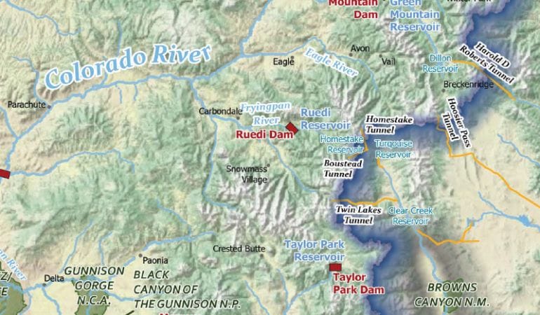
Mapa de derechos resueltos sobre agua superficial para las tribus de la cuenca del río Colorado, acordados mediante litigio (en naranja) y negociación (en azul). Crédito: “The Hardest Working River in the West”, StoryMap del Centro Babbitt.
Si bien al principio los derechos hídricos de las tribus se consideraban como una necesidad para cultivar en las reservas, los acuerdos del s. XX permitieron a algunas de ellas alquilar sus derechos a usuarios ajenos a la reserva. Esto resultó ser una herramienta para el desarrollo económico y una forma de financiar servicios básicos para los miembros de las tribus. Para el pueblo navajo de Arizona, Nuevo México y Utah, vincular el agua con el desarrollo económico “se trata de crear una patria permanente, a donde la gente va, se educa y vuelve a casa”, dice Bidtah Becker, miembro de la tribu y abogada que desde hace mucho se involucra en asuntos hídricos como funcionaria del gobierno del pueblo navajo. “Estamos intentando desarrollar una patria próspera a la cual la gente pueda volver, que funcione”.
En muchos casos, las tribus no tienen la infraestructura física para hacer uso del agua asignada. En todo el país, es 19 veces más probable que un hogar nativo estadounidense no tenga cañerías internas, en comparación con un hogar blanco. En el pueblo navajo, es probable que la falta generalizada de servicios hídricos haya sido una de las causas de las terribles pérdidas que tuvo la tribu por COVID-19. En un momento de 2020, el pueblo tuvo la tasa de infección per cápita más elevada de todos los estados del país (Dyer 2020). “Entre 70.000 y 80.000 navajos siguen acarreando el agua [a su hogar] todos los días”, dice Vigil. “En nuestro país, en 2020, aún hay entre 70.000 y 80.000 personas sin conexión a infraestructura hídrica en una pandemia. Es una locura”.
Vigil es el administrador hídrico del pueblo jicarilla apache de Nuevo México. En un acuerdo de 1992 con el Departamento del Interior de los Estados Unidos (DOI, por su sigla en inglés), se asignaron a la tribu casi 50 millones de metros cúbicos de agua al año (unos 50 mil millones de litros), que alquilaron al operador de una central eléctrica a base de carbón. El alquiler ayudó a financiar pagos anuales a miembros de la tribu durante muchos años. Pero a medida que la economía empezó a virar hacia energías ecológicas, los alquileres no se renovaron. “Así, de pronto nos quedamos con el agua del acuerdo almacenada [en un embalse] a unos 65 a 70 kilómetros, sin poder usarla”, dice Vigil.
Añade que, debido a la sequía actual, la tribu podría alquilar su agua a otras partes sin problemas, pero los términos del acuerdo federal le prohíben alquilar agua por fuera de Nuevo México. En cambio, el agua se escapa de entre las manos de la tribu y cae en las manos de otros usuarios. “No hay mecanismos disponibles para sacar el agua de las fronteras del estado”, dice Vigil. “En los últimos dos años, tuvimos unos 37 millones de metros cúbicos de agua sin alquilar que corrieron por el río”.
La capacidad que tienen las tribus de alquilar agua les puede dar ventaja y un estímulo económico. En un acuerdo de 2004 muy peleado, la comunidad indígena del río Gila (GRIC, por su sigla en inglés) adquirió derechos sobre un volumen de agua dos veces superior al de la ciudad de Las Vegas. Usó esos derechos para convertirse en una gran fuerza, muchas veces subestimada, en políticas hídricas y la política general de Arizona. La tribu participó en negociaciones sobre el Plan de Contingencia ante Sequías (DCP, por su sigla en inglés), un acuerdo de varios años para toda la cuenca firmado en 2019, en respuesta a los impactos de las décadas de sequía (Jenkins 2019).
Durante el proceso del DCP, los estados negociaron sus propios acuerdos; en Arizona, la GRIC aceptó dejar parte de su agua en el lago Mead, el embalse que provee de agua a la cuenca baja, y alquilar otra parte al Distrito de Reabastecimiento de Agua Subterránea del Centro de Arizona para responder a inquietudes sobre suministros de agua a largo plazo para nuevos desarrollos. Ambos acuerdos podrían otorgar hasta US$ 200 millones a la tribu.
También tuvieron una participación importante en el DCP las tribus indígenas del río Colorado (CRIT, por su sigla en inglés), una comunidad que incluye tribus mohave, chemehuevi, hopi y navajo en una reserva junto al río en Arizona y California. La comunidad participó, pero no faltó la controversia interna: algunos miembros se oponían al DCP e intentaron retirar a los miembros de su consejo tribal. Al final, la CRIT acordó dejar hasta el 8 por ciento de su asignación anual en el lago Mead durante tres años a cambio de una compensación de US$ 30 millones del estado de Arizona y una garantía adicional de US$ 8 millones de un grupo de fundaciones y corporaciones organizadas por la fundación Walton Family y la iniciativa Water Funder.
Las negociaciones del DCP fueron complejas y conflictivas. Al final, para llegar a una resolución se necesitó acercar a tribus, ciudades, agricultores y otras partes interesadas importantes.
La relación entre las asignaciones estatales y tribales
Cuando una tribu adquiere el derecho de usar o alquilar cierta cantidad de agua del río Colorado, esa agua se considera como parte de la asignación del estado donde se basa la tribu. Dado que los estados tienen asignaciones individuales de agua bajo las leyes y los acuerdos que rigen al río, los nuevos acuerdos hídricos de las tribus reducen la cantidad de agua disponible para los usuarios de ese estado. Antes, cuando no se usaban las asignaciones tribales de agua, esta quedaba en el sistema para que la usaran otras partes. Este problema es particularmente grave en Arizona, donde tienen reservas 22 de las 29 tribus de la cuenca. Los derechos hídricos de muchas tribus aún no se reconocen y no están cuantificados, resulta lógico que estas y otras partes interesadas sientan ansiedad sobre la disponibilidad del agua en el futuro, con la cuenca asolada por las sequías, y pretendan hallar formas de trabajar en conjunto para garantizar un futuro sostenible.
Desde su concepción, la WTI pretendió mejorar la capacidad de las tribus de promover sus intereses y una gestión sostenible del agua en la cuenca mediante la resolución colaborativa de problemas. “Estamos caminando sobre una cuerda floja”, dice Matt McKinney, quien cofacilita la iniciativa con Vigil. McKinney es mediador desde hace mucho tiempo y dirige el Centro de Recursos Naturales y Políticas Medioambientales en la Universidad de Montana. “Por un lado, es bastante fácil vernos como defensores de las tribus, y lo somos. Pero el marco más amplio es que defendemos un proceso justo, equitativo y efectivo para resolver problemas y tomar decisiones”.
“El éxito de los acuerdos hídricos para las tribus se ha basado en las relaciones de las personas que se reúnen”, dice Margaret Vick, abogada de las tribus indígenas del río Colorado. “Y la iniciativa Water & Tribes hizo que aumentara la [cantidad de] gente en la reunión”. Hoy, la WTI está trabajando para alejarse de las negociaciones estrechas de acuerdos hídricos individuales y acercarse a una conversación mucho más amplia que abarque a toda la cuenca: las pautas actuales de gestión del río vencerán a fines de 2026, y pronto se acordarán otras nuevas para las próximas décadas.
La Oficina de Recuperación de los Estados Unidos (USBR, por su sigla en inglés), la división del DOI que administra el Colorado y otras vías fluviales del oeste, está revisando las negociaciones y operaciones de los últimos quince años a fin de prepararse para la próxima ronda. “Necesitamos un proceso de renegociación más inclusivo”, dice Morgan Snyder, funcionario sénior del programa de medioambiente de la fundación Walton Family. “Esta es la oportunidad de influir en los próximos 25 años de gestión hídrica en la cuenca”.
Para anticiparse al proceso de renegociación, en 2019 McKinney y Vigil realizaron entrevistas con más de 100 personas, entre ellas dirigentes de tribus, gestores hídricos y otras personas vinculadas con asuntos hídricos en la región, para identificar los problemas importantes de la cuenca y buscar modos de promover la resolución colaborativa de problemas, en particular la participación de las tribus en las decisiones acerca del río. La WTI realizó talleres con miembros de tribus y otras partes interesadas de toda la cuenca para identificar estrategias y así aumentar la participación de las tribus y otros participantes.
Vista aérea de una parte de la reserva indígena mohave, de 13.000 hectáreas; cerca de la mitad se usa para cultivar algodón, alfalfa y otras plantas. Crédito: Observatorio de la Tierra/NASA.
“Muchas de las personas entrevistadas creen que es momento de ir más allá de administrar el río como un sistema de plomería e ingeniería que provee de agua a ciudades y granjas, pensar en un sistema más holístico e integrado que responda mejor a múltiples necesidades e intereses, como por ejemplo valores sagrados y culturales de las tribus, valores ecológicos y recreativos, y la integración de decisiones sobre la gestión del suelo y el agua”, escribieron McKinney y Vigil. “Aquí, la intención es articular una visión holística e integrada y luego progresar hacia esa visión de forma gradual en determinado lapso . . . y pasar de un sistema centrado en el uso del agua a la gestión de la cuenca” (WTI 2020).
La WTI está publicando una serie de resúmenes de políticas para concientizar, ayudar a comprender mejor y catalizar conversaciones; los temas abarcan desde la función permanente de las tribus en la cuenca hasta una visión de sostenibilidad para todo el sistema. También está ayudando con el desarrollo de un plan estratégico a Ten Tribes Partnership, una coalición creada en 1992 para aumentar la influencia de las tribus en la gestión del agua del río Colorado.
Pero no será fácil cambiar la índole de las negociaciones sobre la gestión hídrica, y ni hablar de la índole de la gestión hídrica en sí. “Al igual que cualquier otro proceso muy complicado, se debe hallar un modo de desglosarlo”, dice Colby Pellegrino, gerente general adjunto de la Autoridad del Agua del Sur de Nevada, que abastece a Las Vegas y sus suburbios. “Hay que abordar la ley del río Colorado y todos los problemas interrelacionados de a un bocadito a la vez. Esto es problemático si distintos grupos interesados tienen opiniones discrepantes sobre el alcance de las negociaciones”.
Algunas tribus se han frustrado por lo difícil que les resulta hacerse oír, a pesar de que son naciones soberanas. “No somos ‘partes interesadas’”, dice Vigil. “Siempre nos meten en la misma bolsa que las organizaciones sin fines de lucro, grupos conservacionistas. Pero, ‘No, somos soberanos’”.
Los gobiernos estatales y el federal también han dado traspiés importantes. En 2009, la USBR lanzó un estudio importante para evaluar la oferta y demanda actuales y futuras en el río (USBR 2012), pero no se incluyó a las tribus en ese proceso con la relevancia debida. La oficina encargó un estudio de asignaciones hídricas a las tribus solo tras ser presionada por varias de ellas; se hizo con Ten Tribes Partnership y se publicó años más tarde (USBR 2018). El estudio resume las barreras que impiden que las tribus desarrollen sus derechos hídricos por completo y analiza los posibles impactos de que lo hagan, en particular para otros usuarios que ahora dependen del agua que las tribus no usaron durante mucho tiempo. Y en 2013 los estados de la cuenca y el gobierno federal comenzaron los debates sobre el Plan de Contingencia ante Sequías sin notificar a las tribus.
“Los estados ignoraron el uso y los derechos hídricos de las tribus desde el convenio de los 20”, dice Vick. “El [estudio de oferta y demanda] fue un proceso que surgió de los estados; estos no comprendían los derechos hídricos de las tribus y casi no se involucraron siquiera para pensar qué ocurre dentro de la reserva en lo que respecta al uso del agua. Ya no podemos [hacer esto], porque se debe comprender todo para poder administrar la sequía de 20 años que hay ahora”.
Un desafío básico, pero esencial, aún no resuelto es hallar una forma común de comprender y debatir los asuntos relacionados con el río. Anne Castle, exsubsecretaria de agua y ciencia del DOI, responsable de la USBR entre 2009 y 2014, hoy es miembro del equipo de liderazgo de la WTI. “El desafío es que no solo estamos hablando de sumar personas (representantes de las tribus) a las reuniones”, dice. “Esos representantes de las tribus también incorporan distintos valores. Nunca habíamos lidiado de verdad con esos valores culturales, espirituales y ecológicos en estos tipos de debates”.
Castle añade que sortear esa brecha es un proceso lento. “Los gestores hídricos estatales hablan el mismo idioma desde hace tanto tiempo . . . que es difícil exponerse a una forma distinta de hablar sobre el agua”, dice. “Pero lo opuesto también es cierto: [a los representantes de las tribus] les lleva mucho tiempo de sentarse en reuniones y oír para comprender cómo los afectará lo que están diciendo los gestores hídricos estatales”.
Qué sigue
Las renegociaciones venideras “son un punto de inflexión muy importante acerca de cómo los estados de la cuenca y el gobierno federal tratarán la soberanía de las tribus sobre la cuenca de ahora en adelante”, dice Robison, de la Universidad de Wyoming. “Cuando se planee ese proceso, podremos ver hasta qué punto están apartando de nuevo a las tribus a los márgenes. Hasta qué punto los altos cargos federales y de los estados de la cuenca de verdad no tienen intenciones de seguir pateando el asunto”.
Varios organismos hídricos grandes están aportando fondos a la iniciativa Water & Tribes, lo cual es una señal de esperanza para la posible colaboración; algunos de ellos son la Autoridad del Agua del Sur de Nevada, Denver Water, el Distrito de Irrigación de Imperial (CA), el Distrito Metropolitano de Agua del Sur de California y el Proyecto de Arizona Central. Además, The Nature Conservancy y otros grupos ambientalistas han apoyado convocatorias de la WTI.
No queda muy claro cómo las tribus podrían tener una opinión más sustancial en las decisiones acerca del futuro del río. Una propuesta que surgió de las entrevistas de 2019 de la WTI en toda la cuenca es crear un equipo revisor soberano que incluya representantes estatales, federales y tribales, quizás con el complemento de un consejo asesor de representantes de las 29 tribus de la cuenca.
No importa cómo se estructuren las negociaciones, los riesgos son muchos para todas las partes involucradas. Si bien parece haber un compromiso general con el consenso y la colaboración, en el fondo del empeño hay una tensión fundamental. McKinney indica: “Uno de los intereses fundamentales de las tribus es desarrollar y usar sus derechos hídricos. Ese interés parece ser el extremo opuesto de los intereses actuales de los estados de la cuenca y los objetivos del DCP, que se centran en usar menos agua”. Históricamente, el agua que no usaban las tribus terminaba en manos de entidades externas; así, en algunos casos, dichas entidades podían excederse de su asignación. Ahora, en un momento de sequía a largo plazo y cambio climático, hay cada vez menos agua para repartir. “Es evidente”, dice McKinney, “que la cuenca se enfrenta a conversaciones y elecciones complicadas”.
Para muchas tribus, la elección es clara. “Debemos desarrollar nuestros derechos hídricos”, dice Crystal Tulley-Cordova, principal hidróloga del Departamento de Recursos Hídricos del pueblo navajo. “No deberían exigirnos que renunciemos a nuestro desarrollo”.
Uno de los problemas más conflictivos se centra en la posibilidad de que las tribus alquilen el agua a usuarios por fuera de las fronteras de su reserva. Permitir a las tribus alquilar el agua (o no) es una de las fuentes principales de ventaja que tienen los estados individuales sobre las tribus que están dentro de sus fronteras. “Dado que el estado en que se encuentra la reserva administra los derechos hídricos de las tribus, estas deben trabajar con los funcionarios estatales y otros usuarios para hallar soluciones que beneficien a todas las partes y equilibren las necesidades y los intereses”, dice McKinney.
Vigil concuerda, y enfatiza que el derecho de una tribu de hacer lo que quiera con su agua, ya sea usarla para agricultura o desarrollo económico en tierras propias, o alquilarla a otros usuarios, es un axioma clave del principio de autodeterminación codificado en las políticas federales desde los 70. “El núcleo de esto son los conceptos básicos de poder determinar nuestro propio futuro”, dice Vigil. “Y para mí, eso es la soberanía”.
Hallar puntos en común
La WTI ya está ayudando a las tribus a acercarse al tipo de solidaridad que dificultará que cualquier entidad ignore su voz colectiva. Hace poco, 17 dirigentes tribales se unieron para enviar una carta al DOI sobre la próxima etapa de las negociaciones. “Cuando las tribus participan en los debates y acciones importantes sobre el río Colorado, podemos contribuir (como ya lo hemos hecho) con las soluciones creativas necesarias en una época en la que el agua es cada vez más escasa”, decía la carta. “Creemos que la comunicación frecuente, de preferencia cara a cara, es adecuada y constructiva”.
“La ‘ley del río’ siempre evoluciona”, dice Holway, del Centro Babbitt. “Confío en que podremos incorporar mejor las perspectivas y los intereses de una comunidad más amplia en los debates futuros sobre la gestión del río Colorado. Ante una mayor escasez del agua, será esencial contar con una mayor base de partes involucradas. También tengo la esperanza de que podamos ver una voz tribal más fuerte en el Departamento del Interior de los Estados Unidos” (al momento de la publicación, el presidente electo Joe Biden había nominado a la representante Deb Haaland, de Nuevo México, para ser secretaria del interior; Haaland sería la primera nativa de los Estados Unidos en estar a cargo del organismo y la primera secretaria nativa de los Estados Unidos en el gabinete).
Según McKinney, el principio que rige a la WTI es “seguir forjando la cultura de colaboración en la cuenca y centrarse en los puntos en común, crear una sensación de ímpetu al trabajar en el 80 por ciento de los asuntos en los que los dirigentes tribales y otros pueden estar de acuerdo, y luego regresar y abordar esas diferencias”.
Ese enfoque en los puntos en común está ayudando a crear vínculos más fuertes, no solo dentro de las tribus, sino también entre las tribus y la comunidad establecida que gestiona el agua. “Uno de los mejores aspectos de la iniciativa Water & Tribes es que intenta crear una red de gente que puede apoyarse entre sí”, dice Colby Pellegrino. “Es crear un tejido para que la gente pueda cruzar, en vez de una cuerda floja”.
Matt Jenkins es un escritor independiente que ha colaborado con New York Times, Smithsonian, Men’s Journal y muchas otras publicaciones.
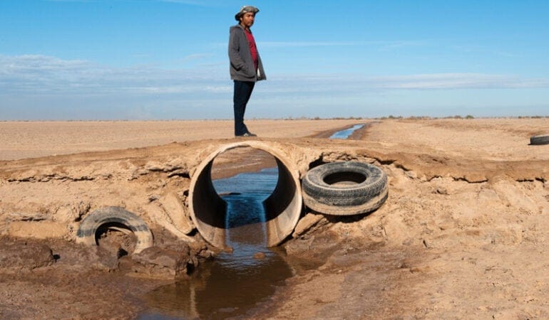
Fotografía: Un miembro de la tribu cocopah examina la antigua zona de pesca de su tribu en el río Colorado. El cambio climático y las sequías intensas están provocando una escasez de agua crítica en toda la cuenca del río Colorado. Crédito: Pete McBride.