Regional Visioning
In the late 1990s, the 10-county Greater Wasatch area of Utah faced the prospect of rapid population growth. Experts projected that by 2020, one million new residents would migrate to cities along the 140-mile-long urban corridor hugging the western edge of the Rocky Mountains and anchored by the state capital, Salt Lake City. The influx would represent a nearly 60-percent increase in population for the region, already home to four in five Utahns.
In an effort to plan for this growth, planners, developers, local government officials, and business leaders embarked on an exhaustive multiyear public outreach campaign, ultimately engaging more than 18,000 residents to develop a collective vision for 2020, with funding from foundation, corporate, and local and state government sources. The result was the Quality Growth Strategy, which has informed policy related to air quality, transportation, water use, housing, and more, in the ensuing decades.
Envision Utah, the nonprofit formed as a result of this effort, recently assessed how close the region came to achieving its vision. The region has progressed in all areas of the plan, to different degrees. Similar to predictions, the population grew by about 954,000 residents. On the issue of transit, the number of people living within a half-mile of a transit stop was about 260,000 higher than if the region hadn’t changed the growth strategies it was using in the 1990s, but 300,000 people short of the goal of 608,000. On land use, if growth had continued along the same trajectory it was on in the 1990s, 130 new square miles would have been developed each decade. However, using tools identified in collaboration with the public to preserve open space and avoid sprawl, the region saw only 63 square miles of additional development per decade, saving an estimated $4.5 billion in infrastructure maintenance.
Scenario Planning for Public Engagement
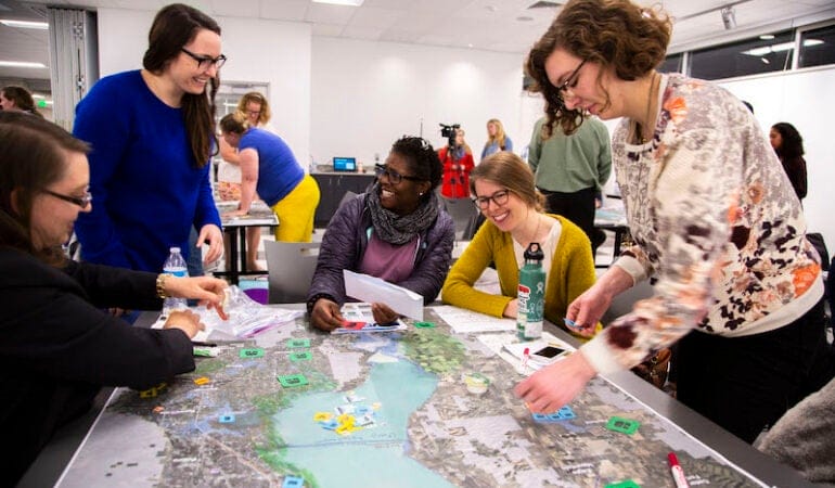
At the center of the project in 1998 was a process called scenario planning, a practice that guides planners, community members, and other stakeholders through considerations of various futures and how to effectively respond to and plan for them. At the start of Envision Utah, leaders engaged the public in the development of several scenarios. During meetings, participants worked together, using tokens to indicate their growth preferences on printed maps. From there, outside consultants extracted common patterns and developed them into four future scenarios—ranging from the continued development of single-family homes and auto-centric infrastructure to walkable communities clustered around town centers. Scenario C, which represented a walkable future, emerged as the clear favorite, based on 17,500 survey responses from the community and additional input from in-person meetings. In the final stage of public outreach, residents ranked the strategies they thought the region should use to get to this scenario, which were incorporated into the final vision.
Since the initial Envision Utah effort, scenario planning has become an increasingly valued tool, in Utah and nationwide, for engaging the public and gaining buy-in. Scenarios allow planners to present data to the public that shows cause and effect, says Ryan Beck, the current vice president of planning at Envision Utah, which still uses scenario strategies in most of its current projects. Beck explains that planners can show the benefit of an approach without using without using technical terms that can be confusing and sometimes politically divisive.
“If you put real data in front of people and real outcomes, it is hard not to make a good decision,” Beck said.
Envision Utah also benefits from its role as a neutral, non-partisan facilitator. The visions and implementation strategies that emerge from Envision Utah’s processes are recommendations, and local officials can choose whether and how to implement them. “It doesn’t feel like anyone is telling them what to do,” Beck said. “That makes it more palatable.” This can help with tensions that sometimes arise between regional planning visions and a desire for local control, Cody Lutz, associate planner at Envision Utah, explained.
By combining factors like transportation and water demand, scenario planning is also a useful way to demonstrate the relationships between different sectors. “By engaging in scenario planning, we are able to think about the interactions between systems that don’t always get treated together,” said Ted Knowlton, deputy director at Wasatch Front Regional Council (WFRC), the Metropolitan Planning Organization for the Salt Lake region. WFRC is cohosting the Lincoln Institute’s upcoming Consortium for Scenario Planning Conference from January 13 through 15. “Transportation infrastructure ideas don’t always think about land use planning changes, real estate market impacts, but they should. That is the way the world actually works.”
Evolution of the Practice
In the years since Envision Utah, scenario planning has become baked into many planning processes in the state. “I think that each time it has happened, it has converted over more skeptics,” Knowlton said. “People have gotten to learn that this is the way to do good planning.“It has become the way of operating in Utah.”
Along the way, practices and tactics have evolved. In place of newspaper ads and radio interviews, planners rely more heavily on social media to reach constituents. Older software and spreadsheet-based modeling tools have been replaced with platforms like UrbanFootprint, a GIS-based scenario planning tool.
Beck explained that, as tools have evolved, outputs have become more reliable. At the same time, Knowlton acknowledged, weakened news infrastructure and an increase in unreliable information has led to some resistance to trusting data that would have been accepted in the past.
Knowlton says that an enduring challenge is convincing members of the public that it is important to start thinking decades into the future. “Even if residents care about the future, they don’t always realize that we are actually talking about decisions that need to start being made now so that over time we get to the [desired] future.”
One tool Knowlton said can be helpful in making the planning process seem immediate and real is having residents focus on smaller areas, such as 15-by-15 mile areas, when evaluating scenarios. “This helps people tie a regional story to a scale with which they are more familiar,” Knowlton added.
Current Work
Envision Utah and the Wasatch Front Regional Council, which often collaborate are currently using scenario planning in a range of ongoing projects.
Both worked with business representatives, educational institutions, and local governments, on the recent 2050 visioning process for Point of the Mountain, an area that sits at the intersection of Wasatch Front’s Salt Lake and Utah County metropolitan areas. The resulting vision would establish the area as a high-tech economic hub, adding 150,000 jobs and increasing incomes, and significantly increasing the number of jobs accessible by transit. The transit strategies that came out of this visioning process were incorporated into the Wasatch Front Regional Council Regional Transportation Plan.
Other projects include Your Utah, Your Future, which used 52,000 survey responses to develop a 2050 statewide plan, and Valley Visioning, a plan for Utah County, one of the counties in the Wasatch Front region, which Envision Utah representatives will discuss at the Consortium for Scenario Planning conference in January.
“We don’t have lessons learned in every aspect of scenario planning,” Knowlton said. “But in some places, like process design and the use of scenarios in a broader campaign, there is quite a bit that we can offer to other places trying to do similar projects.”
Registration for the Consortium for Scenario Planning conference, which will be held virtually January 13-15, is currently open, and includes all conference sessions, presentations, and networking events, as well as access to session recordings for three months following the conference. The conference includes tracks for all levels and interests and features a wide range of scenario planning applications, from pandemic and economic recovery to climate and natural hazards planning to planning for low-growth and legacy cities.
Emma Zehner is communications and publications editor at the Lincoln Institute of Land Policy.
Photograph: Participants at a public workshop for the Valley Visioning plan. Credit: Nathan Brown, Envision Utah.
Related Content
 Great Lakes Communities Use Scenario Planning to Prepare for Rising Waters
 Lincoln Institute Announces Winners of RFP Focused on Equity and Low-Growth Scenarios